|
Yarmouth, Massachusetts
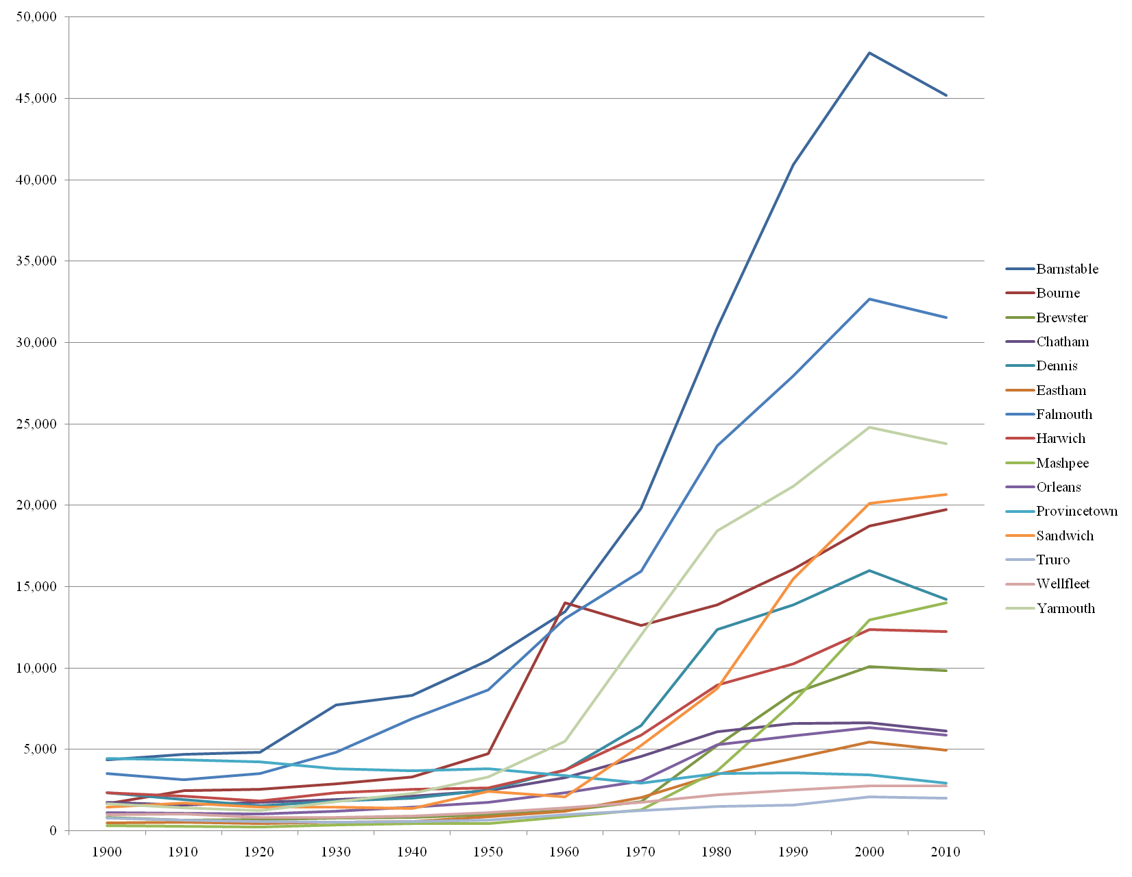
Yarmouth ( ) is a town in Barnstable County, Massachusetts, United States, on Cape Cod. The population was 25,023 at the 2020 census. The town is made up of three major villages: South Yarmouth, West Yarmouth, and Yarmouth Port. History Wampanoag origins Prior to European settlement, Yarmouth was inhabited by the Wampanoag, an Algonquian people. In the Wôpanâak language the area was called "Mattacheese". Wampanoag tribes living in Yarmouth at the time of European settlement included the Pawkunnawkuts on both sides of the lower Bass River, the Hokanums in what is now northeastern Yarmouth, and the Cummaquids in what is now western Yarmouth. Plymouth Colony settlement Yarmouth was organized and incorporated as part of the Plymouth Colony on September 3, 1639, following a settlement led by John Crowe (later Crowell), Thomas Howes and Anthony Thacher, and is, together with Sandwich, the oldest town on Cape Cod. Yarmouth originally included what is now the town of Denni ... [...More Info...] [...Related Items...] OR: [Wikipedia] [Google] [Baidu] |
Barnstable County, Massachusetts
Barnstable County is a County (United States), county in the U.S. state of Massachusetts. At the 2020 United States census, 2020 census, the population was 228,996. The county seat is Barnstable, Massachusetts, Barnstable. The county consists of Cape Cod and associated islands (some adjacent islands are in Dukes County, Massachusetts, Dukes County and Nantucket County). Barnstable County was formed as part of the Plymouth Colony on June 2, 1685, including the towns of Falmouth, Massachusetts, Falmouth, Sandwich, Massachusetts, Sandwich, and others to the east and north on Cape Cod. Plymouth Colony was merged into the Province of Massachusetts Bay in 1691. History Giovanni da Verrazzano Cape Cod is described in a letter from the Italian explorer Giovanni da Verrazzano to Francis I of France, relating the details of a voyage to the New World made on behalf of the French crown in the ship Dauphine, the only surviving of a fleet of four. Sailing from Madeira in 1524, the Dauphine ... [...More Info...] [...Related Items...] OR: [Wikipedia] [Google] [Baidu] |
Geographic Names Information System
The Geographic Names Information System (GNIS) is a database of name and location information about more than two million physical and cultural features, encompassing the United States and its territories; the Compact of Free Association, associated states of the Marshall Islands, Federated States of Micronesia, and Palau; and Antarctica. It is a type of gazetteer. It was developed by the United States Geological Survey (USGS) in cooperation with the United States Board on Geographic Names (BGN) to promote the standardization of feature names. Data were collected in two phases. Although a third phase was considered, which would have handled name changes where local usages differed from maps, it was never begun. The database is part of a system that includes topographic map names and bibliographic references. The names of books and historic maps that confirm the feature or place name are cited. Variant names, alternatives to official federal names for a feature, are also recor ... [...More Info...] [...Related Items...] OR: [Wikipedia] [Google] [Baidu] |
Great Swamp Fight
The Great Swamp Massacre or the Great Swamp Fight was a crucial battle fought during King Philip's War between the colonial militia of New England and the Narragansett people in December 1675. It was fought near the villages of Kingston and West Kingston in the Colony of Rhode Island and Providence Plantations. The combined force of the New England militia included 150 Pequots, and they inflicted a huge number of Narragansett casualties, including many hundreds of women and children. The battle has been described by historians as "one of the most brutal and lopsided military encounters in all of New England's history." Historical context The Pokanoket Indians had helped the original pilgrim settlers to survive, under the leadership of Massasoit. His sons Wamsutta and Metacom took on the English names of Alexander and Philip, respectively. Alexander became sachem of the Pokanokets on the death of his father, but he died within a year and Philip succeeded him in 1662. Philip b ... [...More Info...] [...Related Items...] OR: [Wikipedia] [Google] [Baidu] |
King Philip's War
King Philip's War (sometimes called the First Indian War, Metacom's War, Metacomet's War, Pometacomet's Rebellion, or Metacom's Rebellion) was an armed conflict in 1675–1678 between a group of indigenous peoples of the Northeastern Woodlands against the English New England Colonies and their indigenous allies. The war is named for Metacom (alternatively Metacomet), the Pokanoket chief and sachem of the Wampanoag who had adopted the English name Philip because of the friendly relations between his father Massasoit and the Plymouth Colony. The war continued in the most northern reaches of New England until the signing of the Treaty of Casco Bay on April 12, 1678. Massasoit had maintained a long-standing agreement with the colonists and Metacom (), his younger son, became the tribal chief in 1662 after his father's death. Metacom, however, forsook his father's alliance between the Wampanoags and the colonists after repeated violations by the latter. The colonists insist ... [...More Info...] [...Related Items...] OR: [Wikipedia] [Google] [Baidu] |
Myles Standish
Myles Standish ( – October 3, 1656) was an English military officer and colonist. He was hired as military adviser for Plymouth Colony in present-day Massachusetts, United States by the Pilgrims (Plymouth Colony), Pilgrims. Standish accompanied the Pilgrims on the ship ''Mayflower'' and played a leading role in the administration and defense of Plymouth Colony from its foundation in 1620.Philbrick, p. 84. On February 17, 1621, the Plymouth Colony militia elected him as its first commander and continued to re-elect him to that position for the remainder of his life.Philbrick, p. 88. Standish served at various times as an agent of Plymouth Colony on a return trip to England, as assistant governor of the colony, and as its treasurer. A defining characteristic of Standish's military leadership was his proclivity for preemptive action. He led at least two attacks or small skirmishes against Native Americans in the United States, Native Americans in a raid on the village of Nemaske ... [...More Info...] [...Related Items...] OR: [Wikipedia] [Google] [Baidu] |
Narragansett People
The Narragansett people are an Algonquian American Indian tribe from Rhode Island. Today, Narragansett people are enrolled in the federally recognized Narragansett Indian Tribe. They gained federal recognition in 1983. The tribe was nearly landless for most of the 20th century but acquired land in 1991 and petitioned the Department of the Interior to take the land into trust on their behalf. This would have made the newly acquired land officially recognized as part of the Narragansett Indian reservation, taking it out from under Rhode Island's legal authority. In 2009, the United States Supreme Court ruled against the request in their lawsuit '' Carcieri v. Salazar'', declaring that tribes which had achieved federal recognition since the 1934 Indian Reorganization Act did not have standing to have newly acquired lands taken into federal trust and removed from state control. Reservation The Narragansett tribe was recognized by the federal government in 1983 and controls the N ... [...More Info...] [...Related Items...] OR: [Wikipedia] [Google] [Baidu] |
River Yare
The River Yare is a river in the English county of Norfolk. In its lower reaches it is one of the principal navigable waterways of The Broads and connects with the rest of the network. The river rises south of Dereham to the west to the village of Shipdham. Above its confluence with a tributary stream from Garvestone it is known as the Blackwater River.Ordnance Survey of Great Britain From there it flows in a generally eastward direction passing Barnham Broom and is joined by the River Tiffey before reaching Bawburgh. It then skirts the southern fringes of the city of Norwich, passing through Colney, Cringleford, Lakenham and Trowse. At Whitlingham it is joined by the River Wensum and although the Wensum is the larger and longer of the two, the river downstream of their confluence continues to be called the Yare. Flowing eastward into The Broads it passes the villages of Bramerton, Surlingham, Rockland St. Mary and Cantley. Just before Reedham at Hardley Cross (erecte ... [...More Info...] [...Related Items...] OR: [Wikipedia] [Google] [Baidu] |
Dennis, Massachusetts
Dennis is a New England town, town in Barnstable County, Massachusetts, Barnstable County, Massachusetts, United States, located near the center of the Cape Cod, Cape Cod peninsula. It is a seaside resort town with colonial mansions along the northern Cape Cod Bay coastline and beaches along the southern Nantucket Sound. As of the 2020 United States census, 2020 census, its population was 14,674. The town encompasses five villages, each with its own post office: Dennis (CDP), Massachusetts, Dennis (including North Dennis), Dennis Port, Massachusetts, Dennis Port, East Dennis, Massachusetts, East Dennis, South Dennis, Massachusetts, South Dennis, and West Dennis, Massachusetts, West Dennis. History Indigenous peoples have been living in the Cape Cod region for at least 9,000 years. The historic Algonquian languages, Algonquian-speaking Wampanoag are one of 69 tribes of the original Wampanoag Nation. After being settled by English Settler, colonists of the Plymouth Colony, New ... [...More Info...] [...Related Items...] OR: [Wikipedia] [Google] [Baidu] |
Sandwich, Massachusetts
Sandwich is a town in Barnstable County, Massachusetts, United States and is the oldest town on Cape Cod. The town motto is ''Post tot Naufracia Portus'', "after so many shipwrecks, a haven". The population was 20,259 at the 2020 census. History Cape Cod was inhabited by American Indians prior to European colonization. Sandwich was occupied by the Eastern Algonquian speaking Wampanoag tribe who aided the Pilgrims of Plymouth Colony in the 1620s. The Mashpee Wampanoag Tribe still live on Cape Cod and are making efforts to revive the Wampanoag language. A group of settlers from Saugus, Massachusetts colonized Sandwich in 1637 with the permission of the Plymouth Colony. It is named for the seaport of Sandwich, Kent in England. It was incorporated in 1639 and is the oldest town on Cape Cod, together with Yarmouth. The western portion of the town was separated from the original Town of Sandwich and became the town of Bourne in 1884. Sandwich was the site of an early Quaker s ... [...More Info...] [...Related Items...] OR: [Wikipedia] [Google] [Baidu] |
Plymouth Colony
Plymouth Colony (sometimes spelled Plimouth) was the first permanent English colony in New England from 1620 and the third permanent English colony in America, after Newfoundland and the Jamestown Colony. It was settled by the passengers on the '' Mayflower'' at a location that had previously been surveyed and named by Captain John Smith. The settlement served as the capital of the colony and developed as the town of Plymouth, Massachusetts. At its height, Plymouth Colony occupied most of what is now the southeastern portion of Massachusetts. Many of the people and events surrounding Plymouth Colony have become part of American folklore, including the American tradition of Thanksgiving and the monument of Plymouth Rock. Plymouth Colony was founded by a group of Protestant Separatists initially known as the Brownist Emigration, who came to be known as the Pilgrims. The colony established a treaty with Wampanoag chief Massasoit which helped to ensure its success; in this ... [...More Info...] [...Related Items...] OR: [Wikipedia] [Google] [Baidu] |
Massachusett Language
The Massachusett language is an Algonquian languages, Algonquian language of the Algic languages, Algic language family that was formerly spoken by several peoples of eastern coastal and southeastern Massachusetts. In its revived form, it is spoken in four Wampanoag people, Wampanoag communities. The language is also known as or (Wampanoag), and historically as , Indian or . The language is most notable for its community of literate Native Americans and for the number of translations of religious texts into the language. John Eliot (missionary), John Eliot's translation of the Christian Bible in 1663 using the Natick dialect, known as ''Eliot Indian Bible, Mamusse Wunneetupanatamwe Up-Biblum God'', was the first printed in the Americas, the first Bible translated by a non-native speaker, and one of the earliest examples of a Bible translation into a previously unwritten language. Literate Native American ministers and teachers taught literacy to the elites and other members o ... [...More Info...] [...Related Items...] OR: [Wikipedia] [Google] [Baidu] |
Algonquian Peoples
The Algonquians are one of the most populous and widespread North American indigenous peoples of the Americas, indigenous American groups, consisting of the peoples who speak Algonquian languages. They historically were prominent along the East Coast of the United States, Atlantic Coast and in the interior regions along St. Lawrence River and around the Great Lakes. Before contact with Europeans, most Algonquian settlements lived by hunting and fishing, with many of them supplementing their diet by cultivating maize, corn, beans and Cucurbita, squash (the "Three Sisters (agriculture), Three Sisters"). The Ojibwe cultivated wild rice. Colonial period At the time of European arrival in North America, Algonquian peoples resided in present-day Canada east of the Rocky Mountains, New England, New Jersey, southeastern New York (state), New York, Delaware, and down the East Coast of the United States, Atlantic Coast to the Upper South, and around the Great Lakes in present-day Illino ... [...More Info...] [...Related Items...] OR: [Wikipedia] [Google] [Baidu] |


