|
XMDF
XMDF (eXtensible Model Data Format) is a library providing a standard format for the geometric data storage of river cross-sections, 2D/ 3D structured and unstructured meshes, geometric paths through space, and associated time data. XMDF uses HDF5 for cross-platform data storage and compression. It was initiated in Engineer Research and Development Center (ERDC) and is developed by Aquaveo (formerly the Environmental Modeling Research Laboratory (EMRL) at Brigham Young University). API includes interfaces for C/ C++ and Fortran. An overview of the format was published by the ERDC in 2007. More recent documentation is available online at https://www.xmswiki.com/wiki/XMDF. A binary format was chosen for the data in order to improve performance and data storage as compared with more traditional ASCII grids. The group considered both the NetCDF and HDF5 data formats, and chose HDF5 because it has more flexibility for data storage, compression and data mining. It also supports da ... [...More Info...] [...Related Items...] OR: [Wikipedia] [Google] [Baidu] |
WMS (software)
SMS (Surface-water Modeling System) is a complete program for building and simulating surface water models from Aquaveo. It features 1D and 2D modeling and a unique conceptual model approach. Currently supported models include ADCIRC, CMS-FLOW2D, FESWMS, TABS, TUFLOW, BOUSS-2D, CGWAVE, STWAVE, CMS-WAVE (WABED), GENESIS, PTM, and WAM. Version 9.2 introduced the use of XMDF (eXtensible Model Data Format), which is a compatible extension of HDF5. XMDF files are smaller and allow faster access times than ASCII files. The Watershed Modeling System (WMS) is a proprietary water modeling software application used to develop watershed computer simulations. The software provides tools to automate various basic and advanced delineations, calculations, and modeling processes. It supports river hydraulic and storm drain models, lumped parameter, regression, 2D hydrologic modeling of watersheds, and can be used to model both water quantity and water quality. , supported models include HEC- ... [...More Info...] [...Related Items...] OR: [Wikipedia] [Google] [Baidu] |
NetCDF
NetCDF (Network Common Data Form) is a set of software libraries and self-describing, machine-independent data formats that support the creation, access, and sharing of array-oriented scientific data. The project homepage is hosted by the Unidata program at the University Corporation for Atmospheric Research (UCAR). They are also the chief source of netCDF software, standards development, updates, etc. The format is an open standard. NetCDF Classic and 64-bit Offset Format are an international standard of the Open Geospatial Consortium. History The project started in 1988 and is still actively supported by UCAR. The original netCDF binary format (released in 1990, now known as "netCDF classic format") is still widely used across the world and continues to be fully supported in all netCDF releases. Version 4.0 (released in 2008) allowed the use of the HDF5 data file format. Version 4.1 (2010) added support for C and Fortran client access to specified subsets of remote data via ... [...More Info...] [...Related Items...] OR: [Wikipedia] [Google] [Baidu] |
CGNS
CGNS stands for CFD General Notation System. It is a general, portable, and extensible standard for the storage and retrieval of CFD analysis data. It consists of a collection of conventions, and free and open software implementing those conventions. It is self-descriptive, cross-platform also termed platform or machine independent, documented, and administered by an international steering committee. It is also an American Institute of Aeronautics and Astronautics (AIAA) recommended practice. ThCGNS projectoriginated in 1994 as a joint effort between Boeing and NASA, and has since grown to include many other contributing organizations worldwide. In 1999, control of CGNS was completely transferred to a public forum known as thCGNS Steering Committee{{Webarchive, url=https://web.archive.org/web/20070624200128/http://www.cgns.org/steering.html , date=2007-06-24 . This Committee is made up of international representatives from government and private industry. The CGNS system consists ... [...More Info...] [...Related Items...] OR: [Wikipedia] [Google] [Baidu] |
GMS (software)
GMS (Groundwater Modeling System) is water modeling application for building and simulating groundwater models from Aquaveo. It features 2D and 3D geostatistics, stratigraphic modeling and a unique conceptual model approach. Currently supported models include MODFLOW, MODPATH, MT3DMS, RT3D, FEMWATER, SEEP2D, and UTEXAS. Version 6 introduced the use of XMDF (eXtensible Model Data Format), which is a compatible extension of HDF5. The purpose of this Is to allow internal storage and management of data in a single HDF file, rather than using many flat files. History GMS was initially developed in the late 1980s and early 1990s on Unix workstations by the Engineering Computer Graphics Laboratory at Brigham Young University. The development of GMS was funded primarily by The United States Army Corps of Engineers and was known until version 4.0, released in late 1999, as the ''Department of Defense Groundwater Modeling System'', or ''DoD GMS''. It was ported to Microsoft Windows in ... [...More Info...] [...Related Items...] OR: [Wikipedia] [Google] [Baidu] |
Scientific Data Format
This is a list of file formats used by computers, organized by type. Filename extension is usually noted in parentheses if they differ from the file format's name or abbreviation. Many operating systems do not limit filenames to one extension shorter than 4 characters, as was common with some operating systems that supported the File Allocation Table (FAT) file system. Examples of operating systems that do not impose this limit include Unix-like systems, and Microsoft Windows NT, 95- 98, and ME which have no three character limit on extensions for 32-bit or 64-bit applications on file systems other than pre-Windows 95 and Windows NT 3.5 versions of the FAT file system. Some filenames are given extensions longer than three characters. While MS-DOS and NT always treat the suffix after the last period in a file's name as its extension, in UNIX-like systems, the final period does not necessarily mean that the text after the last period is the file's extension. Some file formats, ... [...More Info...] [...Related Items...] OR: [Wikipedia] [Google] [Baidu] |
BMT Limited
BMT Group Ltd (previously British Maritime Technology), established in 1985, is an international multidisciplinary engineering, science and technology consultancy offering services particularly in the defence and security, critical infrastructure, commercial shipping, and environment sectors. The company's heritage dates to World War II. BMT's head office is in London, United Kingdom. BMT specialises in maritime engineering design, design support, risk and contract management. BMT provides services focused by geography, technology and/or market sector. It employs around 1,500 professionals operating from 47 offices across four continents, with primary bases in South America, Australia, Europe, North America and Asia-Pacific. In August 2017, Sarah Kenny OBE, former Managing Director of QinetiQ, was appointed as Chief Executive Officer. In 2021 she became Chair of Maritime UK. The company's annual turnover for the year 2019 was approx. £176m. History Originally formed from the ... [...More Info...] [...Related Items...] OR: [Wikipedia] [Google] [Baidu] |
HDF5
Hierarchical Data Format (HDF) is a set of file formats (HDF4, HDF5) designed to store and organize large amounts of data. Originally developed at the U.S. National Center for Supercomputing Applications, it is supported by The HDF Group, a non-profit corporation whose mission is to ensure continued development of HDF5 technologies and the continued accessibility of data stored in HDF. In keeping with this goal, the HDF libraries and associated tools are available under a liberal, BSD-like license for general use. HDF is supported by many commercial and non-commercial software platforms and programming languages. The freely available HDF distribution consists of the library, command-line utilities, test suite source, Java interface, and the Java-based HDF Viewer (HDFView). The current version, HDF5, differs significantly in design and API from the major legacy version HDF4. Early history The quest for a portable scientific data format, originally dubbed AEHOO (All Encompassin ... [...More Info...] [...Related Items...] OR: [Wikipedia] [Google] [Baidu] |
C (programming Language)
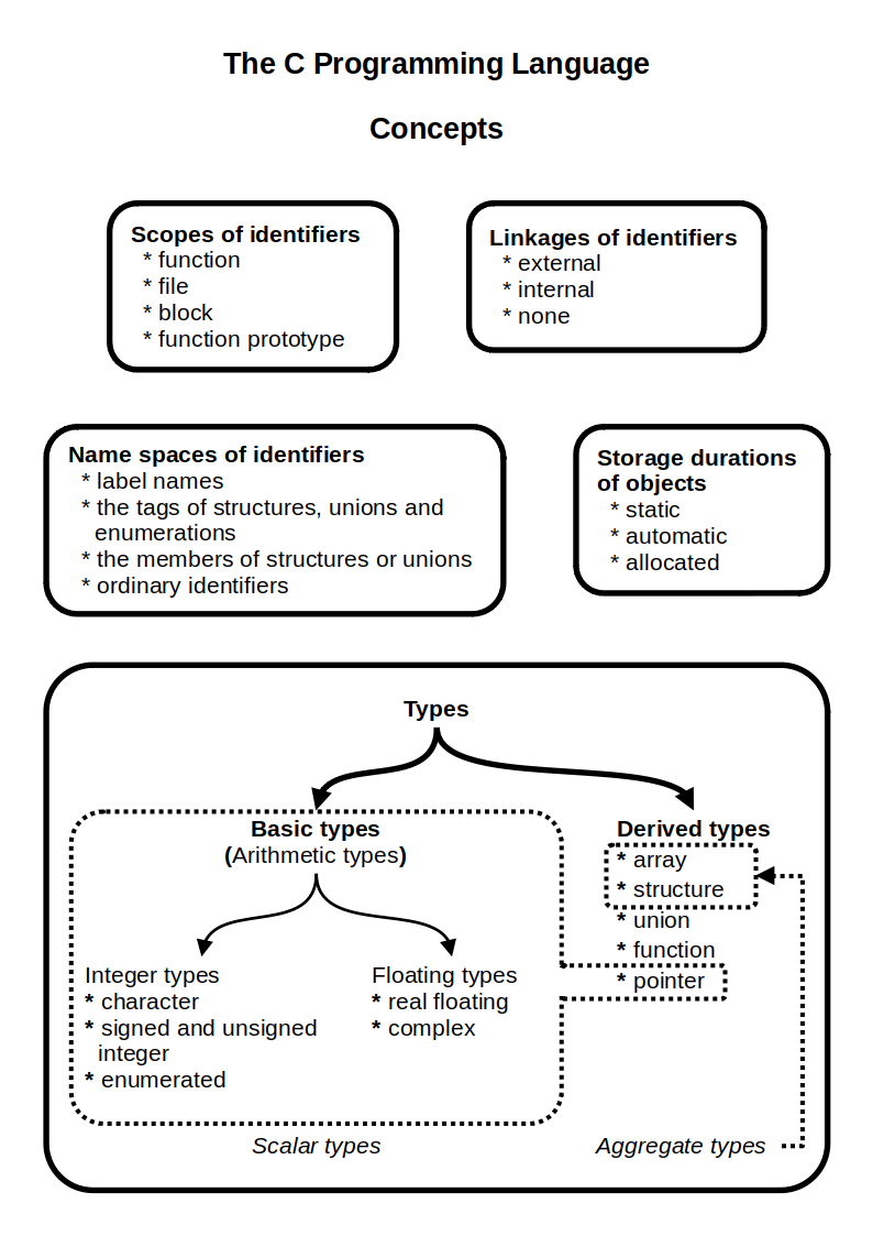
C (''pronounced'' '' – like the letter c'') is a general-purpose programming language. It was created in the 1970s by Dennis Ritchie and remains very widely used and influential. By design, C's features cleanly reflect the capabilities of the targeted Central processing unit, CPUs. It has found lasting use in operating systems code (especially in Kernel (operating system), kernels), device drivers, and protocol stacks, but its use in application software has been decreasing. C is commonly used on computer architectures that range from the largest supercomputers to the smallest microcontrollers and embedded systems. A successor to the programming language B (programming language), B, C was originally developed at Bell Labs by Ritchie between 1972 and 1973 to construct utilities running on Unix. It was applied to re-implementing the kernel of the Unix operating system. During the 1980s, C gradually gained popularity. It has become one of the most widely used programming langu ... [...More Info...] [...Related Items...] OR: [Wikipedia] [Google] [Baidu] |
Brigham Young University
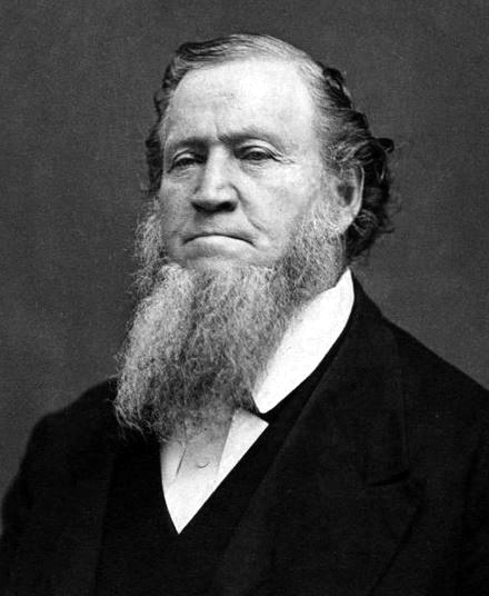
Brigham Young University (BYU) is a Private education, private research university in Provo, Utah, United States. It was founded in 1875 by religious leader Brigham Young and is the flagship university of the Church Educational System sponsored by the Church of Jesus Christ of Latter-day Saints (LDS Church). BYU offers a variety of academic programs including those in the liberal arts, engineering, agriculture, management, physical and mathematical sciences, nursing, and law. Its undergraduate and graduate programs are organized into 11 colleges and schools at its main Provo campus, with some colleges and divisions defining their own admission standards. The university also administers four satellite campuses, one in BYU Jerusalem Center, Jerusalem, BYU Salt Lake Center, Salt Lake City, BYU Barlow Center, Washington, D.C., and BYU London Study Abroad Centre, London, while its parent organization the Church Educational System (CES) sponsors sister schools in Brigham Young Unive ... [...More Info...] [...Related Items...] OR: [Wikipedia] [Google] [Baidu] |

