|
Woppenroth
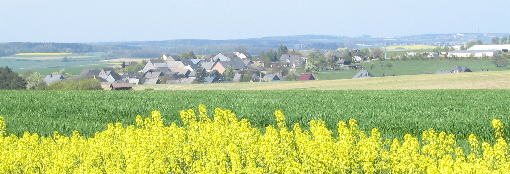
Woppenroth is an ''Ortsgemeinde'' – a municipality belonging to a ''Verbandsgemeinde'', a kind of collective municipality – in the Rhein-Hunsrück-Kreis (district) in Rhineland-Palatinate, Germany. It belongs to the ''Verbandsgemeinde'' of Kirchberg, whose seat is in the like-named town. Geography Location The municipality lies at an elevation of more than 400 m above sea level on a plateau in the central Hunsrück, roughly 7 km south of Kirchberg and 12 km southeast of Frankfurt-Hahn Airport. South of the village looms the Lützelsoon, a small wooded hill region. To the west lies the Hahnenbach valley, and to the east the Kellenbach valley. The plateau stretches northwards to Dickenschied and Kirchberg. East–west through the village runs ''Landesstraße'' (State Road) 162 from Rhaunen to Gemünden, crossing ''Landesstraße'' 184 from Kirchberg to Kirn not far east of the village. Geology In the Hahnenbach valley and its side valleys, Devonian sla ... [...More Info...] [...Related Items...] OR: [Wikipedia] [Google] [Baidu] |
Woppenroth01
Woppenroth is an ''Ortsgemeinde'' – a municipality belonging to a ''Verbandsgemeinde'', a kind of collective municipality – in the Rhein-Hunsrück-Kreis (district) in Rhineland-Palatinate, Germany. It belongs to the ''Verbandsgemeinde'' of Kirchberg, whose seat is in the like-named town. Geography Location The municipality lies at an elevation of more than 400 m above sea level on a plateau in the central Hunsrück, roughly 7 km south of Kirchberg and 12 km southeast of Frankfurt-Hahn Airport. South of the village looms the Lützelsoon, a small wooded hill region. To the west lies the Hahnenbach valley, and to the east the Kellenbach valley. The plateau stretches northwards to Dickenschied and Kirchberg. East–west through the village runs ''Landesstraße'' (State Road) 162 from Rhaunen to Gemünden, crossing ''Landesstraße'' 184 from Kirchberg to Kirn not far east of the village. Geology In the Hahnenbach valley and its side valleys, Devonian slate wa ... [...More Info...] [...Related Items...] OR: [Wikipedia] [Google] [Baidu] |
Bruschied
Bruschied is an ''Ortsgemeinde A Verbandsgemeinde (; plural Verbandsgemeinden) is a low-level administrative division, administrative unit in the Germany, German States of Germany, federal states of Rhineland-Palatinate and Saxony-Anhalt. A Verbandsgemeinde is typically compose ...'' – a Municipalities of Germany, municipality belonging to a ''Verbandsgemeinde'', a kind of collective municipality – in the Bad Kreuznach (district), Bad Kreuznach Districts of Germany, district in Rhineland-Palatinate, Germany. It belongs to the ''Verbandsgemeinde'' Kirner Land, whose seat is in the town of Kirn. Geography Location Bruschied lies in the southern Hunsrück, west of the Lützelsoon plateau. The Lützelsoon Cycleway (''Lützelsoon-Radweg'') runs through the village. Land use As at 31 December 2009, land use in Bruschied breaks down thus: * Agriculture: 37.6% * Woodland: 45.8% * Open water: 1.0% * Residential and transport: 15.6% Neighbouring municipalities Clockwise from the n ... [...More Info...] [...Related Items...] OR: [Wikipedia] [Google] [Baidu] |
Hausen, Birkenfeld
Hausen is an ''Ortsgemeinde'' – a municipality belonging to a ''Verbandsgemeinde'', a kind of collective municipality – in the Birkenfeld district in Rhineland-Palatinate, Germany. It belongs to the ''Verbandsgemeinde'' Herrstein-Rhaunen, whose seat is in Herrstein. Geography Location The municipality lies in the Hahnenbach valley in the central Hunsrück. Its elevation is 300 m above sea level. Neighbouring municipalities Hausen borders the municipality of Oberkirn to the north, the municipality of Woppenroth (Rhein-Hunsrück-Kreis) to the east, the municipality of Bundenbach to the south, and the municipality of Rhaunen to the west. History In 1051, Hausen had its first documentary mention, although the village may be even older, for even then, it had a church. With this church, this village set on top of a cliff terrace overlooking a great bend in the Kyrbach was already earning considerable importance in the Middle Ages as the hub of a great parish, to which, amon ... [...More Info...] [...Related Items...] OR: [Wikipedia] [Google] [Baidu] |
Hunsrück
The Hunsrück () is a long, triangular, pronounced upland in Rhineland-Palatinate, Germany. It is bounded by the valleys of the Moselle-Saar (north-to-west), the Nahe (south), and the Rhine (east). It is continued by the Taunus mountains, past the Rhine and by the Eifel past the Moselle. To the south of the Nahe is a lower, hilly country forming the near bulk of the Palatinate region and all of the, smaller, Saarland. Below its north-east corner is Koblenz. As the Hunsrück proceeds east it acquires north-south width and three notable gaps in its southern ridges. In this zone are multi-branch headwaters including the Simmerbach ending at Simmertal on the southern edge. This interior is therefore rarely higher than above sea level. Peaks and escarpments are principally: the (Black Forest) Hochwald, the Idar Forest, the Soonwald, and the Bingen Forest. The highest mountain is the Erbeskopf (816 m; 2,677 ft), towards the region's south-west. Notable towns are Simmern, ... [...More Info...] [...Related Items...] OR: [Wikipedia] [Google] [Baidu] |
Schneppenbach
Schneppenbach is an ''Ortsgemeinde'' – a municipality belonging to a ''Verbandsgemeinde'', a kind of collective municipality – in the Bad Kreuznach district in Rhineland-Palatinate, Germany. It belongs to the ''Verbandsgemeinde'' Kirner Land, whose seat is in the town of Kirn. Geography Location Schneppenbach lies in the southern Hunsrück on the western edge of the Lützelsoon ridge and east of (above) the Hahnenbach valley. The nearest major towns are Idar-Oberstein (17 km to the south-southwest) and Simmern (17 km to the north-northeast). Schneppenbach sits at an elevation of 424 m above sea level. Neighbouring municipalities Clockwise from the north, Schneppenbach's neighbours are the municipalities of Woppenroth, which lies in the neighbouring Rhein-Hunsrück-Kreis, Bruschied, which lies in the Bad Kreuznach district, and Bundenbach, which lies in the neighbouring Birkenfeld district. History From the Early Middle Ages, Schneppenbach belonged to a m ... [...More Info...] [...Related Items...] OR: [Wikipedia] [Google] [Baidu] |
Dickenschied
Dickenschied is an ''Ortsgemeinde'' – a municipality belonging to a ''Verbandsgemeinde'', a kind of collective municipality – in the Rhein-Hunsrück-Kreis (district) in Rhineland-Palatinate, Germany. It belongs to the ''Verbandsgemeinde'' of Kirchberg, whose seat is in the like-named town. Geography Location The municipality lies on a ridge in the Hunsrück five kilometres south of Kirchberg. To the east lies the Simmerbach valley, to the west lies the Kyrbach valley and to the south looms a hill region called the Lützelsoon. History Prehistory and early history The Dickenschied area was settled as early as the New Stone Age, as witnessed by finds in the neighbouring municipalities of Woppenroth and Gemünden. After the Stone Age and the Bronze Age, the Hunsrück's, and thereby also Dickenschied's, prehistory and early history was marked by the Celts (600-50 BC), the Romans (50 BC-AD 300) and the Franks (300-1000). Within Dickenschied's municipal limits, Celtic bury ... [...More Info...] [...Related Items...] OR: [Wikipedia] [Google] [Baidu] |
Lützelsoon
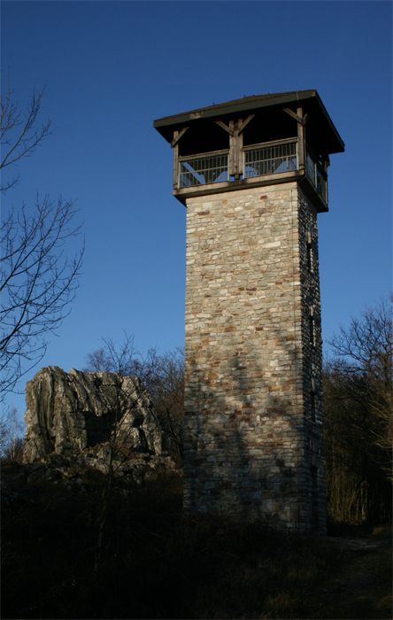
The Lützelsoon (also called the Kleiner Soon) is a part of the Hunsrück hills, , in the county of Bad Kreuznach, in the state of Rhineland-Palatinate. Location The Lützelsoon is a hill ridge southwest of the Soonwald range and north of Hennweiler between the Kellenbach valley (the lower course of the Simmerbach) to the east and northeast and the Hahnenbach valley to the west and southwest. Other plateaux of the Hunsrück border to the north and south. On its ridgeline are several large quartz formations like the ''Teufelsfels'', the ''Blickensteine'' and the ''Katzensteine''. Tourism The Lützelsoon, which is covered by natural woodland and criss-crossed by paths, is not a particularly well known tourist area, yet offers trails especially suitable for hikers and cyclists, as well as those interested in castles, conservation or geology. Popular destinations are the viewing points of Blickenstein, Katzenstein and the Teufelsfels with its observation tower. The slate ... [...More Info...] [...Related Items...] OR: [Wikipedia] [Google] [Baidu] |
Rhein-Hunsrück-Kreis
Rhein-Hunsrück-Kreis is a district (german: Kreis) in the middle of Rhineland-Palatinate, Germany. The neighbouring districts are (from north clockwise) Mayen-Koblenz, Rhein-Lahn, Mainz-Bingen, Bad Kreuznach, Birkenfeld, Bernkastel-Wittlich, Cochem-Zell. History The district was created in 1969, when the districts of St. Goar and Simmern were merged. In 2014 it was expanded with the municipalities Lahr, Mörsdorf and Zilshausen, previously part of Cochem-Zell. Geography The name of the district already mentions the two main geographic features of the district - the river Rhine which forms the boundary to the north-east and the hills of the Hunsrück cover most of the area of the district. The Frankfurt-Hahn Airport is located in the district. Partnerships In 1962, Simmern began a friendship pact with the French region Bourgogne, which was continued after the merging with the St. Goar. In 1985 a partnership was started with the district Nyaruguru (at that time called the mu ... [...More Info...] [...Related Items...] OR: [Wikipedia] [Google] [Baidu] |
Lindenschied
Lindenschied is an ''Ortsgemeinde'' – a municipality belonging to a ''Verbandsgemeinde'', a kind of collective municipality – in the Rhein-Hunsrück-Kreis (district) in Rhineland-Palatinate, Germany. It belongs to the ''Verbandsgemeinde'' of Kirchberg, whose seat is in the like-named town. Geography Location The municipality lies in the Hunsrück on a ridge. West of the village flows the Kyrbach and to the east lies Dickenschied, through which runs ''Bundesstraße'' 421. Lindenschied lies roughly 5 km south of Kirchberg, 12 km southwest of Simmern and 9 km southeast of Frankfurt-Hahn Airport. The municipal area measures 317 ha, of which 66 ha is wooded. History In 1345, Lindenschied, which was then under the High Court of Rhaunen, had its first documentary mention. The document itself stated Lindenschied's, and several other villages’, legal status, which at this time was disputed, particularly as to these villages’ rights and boundaries, b ... [...More Info...] [...Related Items...] OR: [Wikipedia] [Google] [Baidu] |
Oberkirn
Oberkirn is an ''Ortsgemeinde'' – a municipality belonging to a ''Verbandsgemeinde'', a kind of collective municipality – in the Birkenfeld district in Rhineland-Palatinate, Germany. It belongs to the ''Verbandsgemeinde'' Herrstein-Rhaunen, whose seat is in Herrstein. Geography Location The municipality lies in the Kyrbach valley between the Lützelsoon (a small, wooded plateau) to the southeast and the Idar Forest to the southwest, in the central Hunsrück. As of 31 December 2010, Oberkirn's population is 333. The municipal area comprises some 200 ha of forest and another 300 ha of meadowland. Neighbouring municipalities Oberkirn's neighbours are Rhaunen, Gösenroth, Schwerbach, Lindenschied, Rohrbach, Woppenroth and Hausen. History There was clearly a Roman presence in what is now Oberkirn, for the Evangelical church on the village's upper outskirts is built on the foundations of an old Roman villa rustica. The plain, Gothic church itself was built a few years ... [...More Info...] [...Related Items...] OR: [Wikipedia] [Google] [Baidu] |
Kirchberg (Verbandsgemeinde)
Kirchberg is a ''Verbandsgemeinde'' ("collective municipality") in the Rhein-Hunsrück district, in Rhineland-Palatinate, Germany. Its seat is in Kirchberg. The ''Verbandsgemeinde'' Kirchberg consists of the following ''Ortsgemeinden'' ("local municipalities"): Verbandsgemeinde in Rhineland-Palatinate {{RheinHunsrück-geo-stub ... [...More Info...] [...Related Items...] OR: [Wikipedia] [Google] [Baidu] |
Rhaunen
Rhaunen is an ''Ortsgemeinde'' – a municipality belonging to a ''Verbandsgemeinde'', a kind of collective municipality – in the Birkenfeld district in Rhineland-Palatinate, Germany. It was the seat of the former ''Verbandsgemeinde'' Rhaunen. Geography Location The municipality lies at the Idar Forest in the Hunsrück in a sprawling, well watered hollow. The hollow separates the Idar Forest massif from the Soonwald massif. Within the village itself, the Lingenbach empties into the Rhaunelbach, which itself, along with the Näßbach, the Macherbach and the Büdenbach, empties into the Idarbach. The nearest major centres are Idar-Oberstein, Simmern, Morbach and Kirn. Constituent communities Also belonging to Rhaunen are the outlying centre of Neuzenbrunnen and the homesteads of Hochwälderhof and Königstein. Geology The solid rock in Rhaunen, Hunsrück slate, comes down from the Devonian. The hollow in which Rhaunen lies was formed by the many brooks that flow together her ... [...More Info...] [...Related Items...] OR: [Wikipedia] [Google] [Baidu] |


