|
William Hamond Bartholomew
William Hamond Bartholomew (30 January 1831 – 19 November 1919) was an engineer in West Yorkshire, England who was responsible for the expansion of the Aire and Calder Navigation in the 19th century and invented a number of improvements in coal-handling which led to the expansion of Goole as one of the largest exporters of coal in the country. Early life His father, ''Thomas Hamond Bartholomew'', was the chief engineer of the Aire and Calder Navigation, which was the transport hub of the expanding Yorkshire industry based on Leeds, Sheffield and the Yorkshire coalfields, from 1825 to 1853. William was born at ''Lake Lock'', Stanley, West Yorkshire and was appointed as engineer of the company at the age of 22, on the death of his father at a period when the company was generating up to 150% dividends to its shareholders. At the age of 29 he married ''Maria Wilson'' with whom he had two daughters and a son. Canal Engineer and Inventor During his time as engineer he oversaw the ... [...More Info...] [...Related Items...] OR: [Wikipedia] [Google] [Baidu] |
Aire And Calder Navigation
The Aire and Calder Navigation is the canalised section of the Rivers Aire and Calder in West Yorkshire, England. The first improvements to the rivers above Knottingley were completed in 1704 when the Aire was made navigable to Leeds and the Calder to Wakefield, by the construction of 16 locks. Lock sizes were increased several times, as was the depth of water, to enable larger boats to use the system. The Aire below Haddlesey was bypassed by the opening of the Selby Canal in 1778. A canal from Knottingley to the new docks and new town at Goole provided a much shorter route to the River Ouse from 1826. The New Junction Canal was constructed in 1905, to link the system to the River Don Navigation, by then part of the Sheffield and South Yorkshire Navigation. Steam tugs were introduced in 1831. In the 1860s, compartment boats were introduced, later called Tom Puddings, from which coal was unloaded into ships by large hydraulic hoists. This system enabled the canal to carry at ... [...More Info...] [...Related Items...] OR: [Wikipedia] [Google] [Baidu] |
Goole
Goole is a port town and civil parish on the River Ouse in the East Riding of Yorkshire, England. The town's historic county is the West Riding of Yorkshire. According to the 2011 UK census, Goole parish had a population of 19,518, an increase on the 2001 UK census figure of 17,600. It is north-east of Doncaster, south of York and west of Hull. The town has the United Kingdom's furthest inland port, being about from the North Sea. It is capable of handling nearly 2 million tonnes of cargo per year, making it one of the most important ports on England's east coast. Goole is twinned with Złotów in Poland. Goole was informally twinned with Gibraltar in the 1960s; at that time, Gibraltar Court was named in Goole and Goole Court was named in Gibraltar. History Etymology Goole is first attested in 1306, as ''Gull Lewth'' (where ''lewth'' means 'barn', from Old Norse ''hlaða''), and then 1362 as ''Gulle in Houke (referring to the nearby, and then more significant, vi ... [...More Info...] [...Related Items...] OR: [Wikipedia] [Google] [Baidu] |
Stanley, West Yorkshire
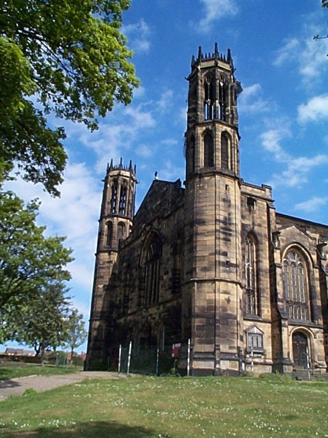
Stanley is a village in the Metropolitan Borough of Wakefield in West Yorkshire, England. It is about north-east of Wakefield city centre. Stanley was an Urban District in the West Riding of Yorkshire before 1974, being made up the four electoral wards of Lake Lock, Outwood, Stanley and Wrenthorpe. The Lofthouse / Stanley area of West Yorkshire has a combined population of 22,947. The ward remaining at the 2011 Census was called Stanley and Outwood East. The population of this ward at the 2011 Census was 15,314. Geography and amenities Stanley's physical footprint is larger than that of its parent City Wakefield. Whilst often considered being a village, Stanley is actually an array of individual settlements such as The Grove, Stanley Ferry, Lee Moor and Lane Ends. Lane Ends is often perceived as the "village" centre Stanley consists of the main village and neighbouring areas including Lee Moor, Lane Ends, The Grove and Stanley Ferry. Sometimes Bottom Boat is considered part ... [...More Info...] [...Related Items...] OR: [Wikipedia] [Google] [Baidu] |
Tom Pudding
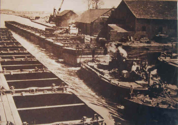
Tom Pudding was the name given to the tub boats on the Aire and Calder Navigation, introduced in 1863 and used until 1985, which were a very efficient means of transferring and transporting coal from the open cast collieries of the South Yorkshire Coalfield near Stanley Ferry to the port of Goole, competing with rail. The name derives from their resemblance to a string of black puddings or perhaps Yorkshire puddings and the first name of the original constructor. Background The use of trains of boats to move bulk products has a long history. In the 1760s, the Third Duke of Bridgwater developed the Navigable Levels at Worsley, which were a series of underground navigable tunnels serving coal workings. They were linked to the Bridgwater Canal, and two sizes of boats were used both underground and on the canal. 'M' boats were and carried 10 tons of coal, while 'T' boats were and carried 7 tons. They were pointed at both ends, as they could not be turned below ground, and were mad ... [...More Info...] [...Related Items...] OR: [Wikipedia] [Google] [Baidu] |
Knottingley
Knottingley is a market town in the City of Wakefield in West Yorkshire, England on the River Aire and the old A1 road (Great Britain), A1 road before it was bypassed as the A1(M). Historic counties of England, Historically part of the West Riding of Yorkshire, it has a population of 13,503, increasing to 13,710 for the City of Wakefield ward at the 2011 Census. It makes up the majority of the Knottingley (electoral ward), Knottingley ward represented on Wakefield Council. Until 1699, it was an important inland river port but, in that year, the Aire was made navigability, navigable as far as Leeds, which soon surpassed it. Knottingley continued as a centre for boat building into the 20th century. In the late 19th century, it started glass manufacturing. The town is served by Knottingley railway station. After 1870, the town became known for glass manufacturing. In 1887 Bagley's Glassworks purchased the rights to the first bottle-making machine, invented by a Ferrybridge postmast ... [...More Info...] [...Related Items...] OR: [Wikipedia] [Google] [Baidu] |
Transhipment
Transshipment, trans-shipment or transhipment is the shipment of goods or containers to an intermediate destination, then to another destination. One possible reason for transshipment is to change the means of transport during the journey (e.g., from ship transport to road transport), known as transloading. Another reason is to combine small shipments into a large shipment (consolidation), or the opposite: dividing a large shipment into smaller shipments (deconsolidation). Transshipment usually takes place in transport hubs. Much international transshipment also takes place in designated customs areas, thus avoiding the need for customs checks or duties, otherwise a major hindrance for efficient transport. An item handled (from the shipper's point of view) as a single movement is not generally considered transshipped, even if it changes from one mode of transport to another at several points. Previously, it was often not distinguished from transloading, since each leg of such a ... [...More Info...] [...Related Items...] OR: [Wikipedia] [Google] [Baidu] |
River Ouse, Yorkshire
The River Ouse ( ) is a river in North Yorkshire, England. Hydrologically, the river is a continuation of the River Ure, and the combined length of the River Ure and River Ouse makes it, at , the sixth-longest river of the United Kingdom and (including the Ure) the longest to flow entirely in one county. The length of the Ouse alone is about but the total length of the river is disputed. It is a matter of opinion as to whether the River Ouse is formed at the confluence of the River Ure and the much-smaller Ouse Gill Beck at Cuddy Shaw Reach near Linton-on-Ouse, about six miles downstream of the confluence of the River Swale with the River Ure. An alternative opinion is recorded in a publication published in ''The Yorkshire Post'' in a series dated 1891, written and illustrated by Tom Bradley. His description and bird's-eye-view maps—specifically in his account of the River Swale—suggests that the River Ouse starts at the confluence of the Swale and the Ure. His narrative ... [...More Info...] [...Related Items...] OR: [Wikipedia] [Google] [Baidu] |
Trent Falls
Trent Falls is the confluence of the River Ouse and the River Trent which forms the Humber between Lincolnshire and the East Riding of Yorkshire in England. Location The River Ouse flows to the east where it turns into the Humber, and the River Trent flows northwards. It curves to the east near the confluence, although this is largely engineered, rather than natural. A training wall was built on the western bank of the Trent after the First World War, in an attempt to keep the channel in a known position. The rivers deposit large volumes of silt in this area, and charts for coastal shipping have to be updated monthly, but for smaller vessels, the channel can be considered to be reasonably static. Despite the training wall and a mini-lighthouse called ' Apex Light' which is situated at the end of the wall, navigation at Trent Falls is not simple. There are no real waterfalls, but there is a very rapid race of water at difficult stages of the tide (especially spring tides), an ... [...More Info...] [...Related Items...] OR: [Wikipedia] [Google] [Baidu] |
Sheffield And South Yorkshire Navigation
The Sheffield and South Yorkshire Navigation (S&SY) is a system of navigable inland waterways (canals and canalised rivers) in South Yorkshire and Lincolnshire, England. Chiefly based on the River Don, it runs for a length of and has 27 locks. It connects Sheffield, Rotherham, and Doncaster with the River Trent at Keadby and (via the New Junction Canal) the Aire and Calder Navigation. The system consisted of five parts, four of which are still open to navigation today:- * The River Don Navigation * The Sheffield Canal (effectively abandoned in the early 1970s but revitalised since the 1990s) * The Stainforth and Keadby Canal * The New Junction Canal * The Dearne and Dove Canal (closed 1961) History The River Don is known to have been navigable up to Doncaster as early as 1343, when a commission looked at the problems caused by bridges and weirs. It underwent major changes in the 1620s, when Cornelius Vermuyden closed the channel which crossed Hatfield Chase to reach the Riv ... [...More Info...] [...Related Items...] OR: [Wikipedia] [Google] [Baidu] |
New Junction Canal
The New Junction Canal is a canal in South Yorkshire, England. It is part of the Sheffield and South Yorkshire Navigation (S&SYN), although it was jointly funded by the Aire and Calder Navigation, and was opened in 1905. It links the River Don Navigation and the Stainforth and Keadby Canal with the Aire and Calder Navigation (Knottingley Canal). It is completely straight, and was the last canal built in England for commercial purposes. The canal has one lock, which was sized to allow the compartment boats of the Aire and Calder to use it, but the owning company failed to raise enough money to upgrade the River Don Navigation beyond, and Long Sandall lock prevented working of such boats through to Doncaster until it was rebuilt in 1959. There is still some commercial traffic on the canal, but most use is now by leisure boaters. One notable feature is the aqueduct over the River Don which is protected by large guillotine gates, which can be lowered when the Don is in spate, to p ... [...More Info...] [...Related Items...] OR: [Wikipedia] [Google] [Baidu] |
English Canal Engineers
English usually refers to: * English language * English people English may also refer to: Peoples, culture, and language * ''English'', an adjective for something of, from, or related to England ** English national identity, an identity and common culture ** English language in England, a variant of the English language spoken in England * English languages (other) * English studies, the study of English language and literature * ''English'', an Amish term for non-Amish, regardless of ethnicity Individuals * English (surname), a list of notable people with the surname ''English'' * People with the given name ** English McConnell (1882–1928), Irish footballer ** English Fisher (1928–2011), American boxing coach ** English Gardner (b. 1992), American track and field sprinter Places United States * English, Indiana, a town * English, Kentucky, an unincorporated community * English, Brazoria County, Texas, an unincorporated community * Engli ... [...More Info...] [...Related Items...] OR: [Wikipedia] [Google] [Baidu] |
English Inventors
English usually refers to: * English language * English people English may also refer to: Peoples, culture, and language * ''English'', an adjective for something of, from, or related to England ** English national identity, an identity and common culture ** English language in England, a variant of the English language spoken in England * English languages (other) * English studies, the study of English language and literature * ''English'', an Amish term for non-Amish, regardless of ethnicity Individuals * English (surname), a list of notable people with the surname ''English'' * People with the given name ** English McConnell (1882–1928), Irish footballer ** English Fisher (1928–2011), American boxing coach ** English Gardner (b. 1992), American track and field sprinter Places United States * English, Indiana, a town * English, Kentucky, an unincorporated community * English, Brazoria County, Texas, an unincorporated community * Engl ... [...More Info...] [...Related Items...] OR: [Wikipedia] [Google] [Baidu] |


.jpg)


