|
Wildlife Of Cape Verde
The wildlife of Cape Verde is spread over its archipelago of ten islands and three islets, which all have parks under their jurisdiction by decree promulgated by the Cape Verde government. Located off the west coast of Africa, the total land area of the island nation is . The wildlife consists of many tropical dry forest and shrub land, endemic flora and fauna, and rare breeding seabirds and plants, which are unique to this group of islands. Some of the wildlife species of Cape Verde are considered as endemic, evolving over millions of years of isolation; the grey-headed kingfisher (''Halcyon leucocephala'') survived here on insects in the absence of water in the lands of the islands. In the process of development, many lands in the islands were converted to agricultural fields and several hundred varieties of herbaceous plant and tree species were introduced, resulting in depletion of the original vegetation. However, efforts are now underway at reforestation to improve the ... [...More Info...] [...Related Items...] OR: [Wikipedia] [Google] [Baidu] |
Location Cape Verde AU Africa
In geography, location or place are used to denote a region (point, line, or area) on Earth's surface or elsewhere. The term ''location'' generally implies a higher degree of certainty than ''place'', the latter often indicating an entity with an ambiguous boundary, relying more on human or social attributes of place identity and sense of place than on geometry. Types Locality A locality, settlement, or populated place is likely to have a well-defined name but a boundary that is not well defined varies by context. London, for instance, has a legal boundary, but this is unlikely to completely match with general usage. An area within a town, such as Covent Garden in London, also almost always has some ambiguity as to its extent. In geography, location is considered to be more precise than "place". Relative location A relative location, or situation, is described as a displacement from another site. An example is "3 miles northwest of Seattle". Absolute location An absolute locati ... [...More Info...] [...Related Items...] OR: [Wikipedia] [Google] [Baidu] |
West Africa
West Africa or Western Africa is the westernmost region of Africa. The United Nations defines Western Africa as the 16 countries of Benin, Burkina Faso, Cape Verde, The Gambia, Ghana, Guinea, Guinea-Bissau, Ivory Coast, Liberia, Mali, Mauritania, Niger, Nigeria, Senegal, Sierra Leone, and Togo, as well as Saint Helena, Ascension and Tristan da Cunha ( United Kingdom Overseas Territory).Paul R. Masson, Catherine Anne Pattillo, "Monetary union in West Africa (ECOWAS): is it desirable and how could it be achieved?" (Introduction). International Monetary Fund, 2001. The population of West Africa is estimated at about million people as of , and at 381,981,000 as of 2017, of which 189,672,000 are female and 192,309,000 male. The region is demographically and economically one of the fastest growing on the African continent. Early history in West Africa included a number of prominent regional powers that dominated different parts of both the coastal and internal trade networks, suc ... [...More Info...] [...Related Items...] OR: [Wikipedia] [Google] [Baidu] |
Brava, Cape Verde
Brava (Portuguese for "wild" or "brave") is an island in Cape Verde, in the Sotavento group. At , it is the smallest inhabited island of the Cape Verde archipelago, but at the same time the greenest. First settled in the early 16th century, its population grew after Mount Fogo on neighbouring Fogo erupted in 1680. For more than a century, its main industry was whaling, but the island economy is now primarily agricultural. History Brava was discovered in 1462 by the Portuguese explorer Diogo Afonso.Valor simbólico do centro histórico da Praia Lourenço Conceição Gomes, Universidade Portucalense, 2008, p. 97 There is no evidence of human presence on the Cape Verde islands before the arrival of the Portuguese. Around 1620 the population of Brava started with the arrival of settlers from |
Fogo, Cape Verde
Fogo (Portuguese for "fire") is an island in the Sotavento group of Cape Verde. Its population is 35,837 (2015),Cabo Verde, Statistical Yearbook 2015 Instituto Nacional de Estatística with an area of 476 km2. It reaches the highest altitude of all the islands in Cape Verde, rising to at the summit of its active volcano, |
Santiago, Cape Verde
Santiago (Portuguese for “ Saint James”) is the largest island of Cape Verde, its most important agricultural centre and home to half the nation's population. Part of the Sotavento Islands, it lies between the islands of Maio ( to the east) and Fogo ( to the west). It was the first of the islands to be settled: the town of Ribeira Grande (now Cidade Velha and a UNESCO World Heritage Site) was founded in 1462. Santiago is home to the nation's capital city of Praia. History The eastern side of the nearby island of Fogo collapsed into the ocean 73,000 years ago, creating a tsunami 170 meters high which struck Santiago. In 1460, António de Noli became the first to visit the island. Da Noli settled at ''Ribeira Grande'' (now Cidade Velha) with his family members and Portuguese from Algarve and Alentejo in 1462.Valor simbóli ... [...More Info...] [...Related Items...] OR: [Wikipedia] [Google] [Baidu] |
Maio, Cape Verde
Maio is the easternmost of the Sotavento islands of Cape Verde. Maio is located south of the island of Boa Vista and east of Santiago. Administratively, the island forms one ''concelho'' (municipality): Maio. History The island was discovered in 1460. It was first settled at the end of the 16th century, when the land was used to raise livestock, especially goats. Salt was first exploited in the 17th century which caused the population to grow. The English exported salt to Europe from Porto Inglês, hence the name of that city.História Municipio do Maio The inconclusive was fought between British and French |
Boa Vista, Cape Verde
Boa Vista (Portuguese for "good view"), also written as Boavista, is a desert-like island that belongs to the Cape Verde Islands. At , it is the third largest island of the Cape Verde archipelago. The island of Boa Vista is closer to the African continent than all the other islands in Cape Verde, being the easternmost island of all. The distance between Boa Vista and Senegal is only 450 km. The capital of Boa Vista, Sal Rei, is located in the north-western part of the island. Boa Vista is mainly known for its beaches, turtles and traditional music. Geography Boa Vista is the third largest island after Santo Antão and Santiago, with an area of 631.1 square kilometres. It is situated south of Sal and north of Maio. The island is generally flat, but it has numerous hills like Monte Estância (the highest point of the island at 387 m), [...More Info...] [...Related Items...] OR: [Wikipedia] [Google] [Baidu] |
Sal, Cape Verde
Sal (Portuguese for "salt") is an island in Cape Verde. Sal is a tourist destination with white sandy beaches and over 350 days of sunshine a year. It is one of the three sandy eastern islands of the Cape Verde archipelago in the central Atlantic Ocean, off the west coast of Africa. Cabo Verde is known for year-round kiteboarding, for the large reserve of Caretta turtles which hatch from July to September, and the music of Cesaria Evora. History For Europeans , the island was discovered on 3 December 1460 and named ''Llana'' ("flat"). This name was changed into the current "Sal" when the two large salt ponds (Pedra de Lume and Santa Maria) were discovered. The first three centuries after its discovery, the island was only sparsely inhabited; in 1720 there was a small fishing village near present Palmeira. This changed when the salt industry was developed at the end of the 18th century, starting in Pedra de Lume. Santa Maria was founded in the south of the island in 1830 by ... [...More Info...] [...Related Items...] OR: [Wikipedia] [Google] [Baidu] |
São Nicolau, Cape Verde
São Nicolau (Portuguese for ''Saint Nicholas'') is one of the Barlavento (Windward) islands of Cape Verde. It is located between the islands of Santa Luzia and Sal. Its population is 12,424 (2015),Cabo Verde, Statistical Yearbook 2015 Instituto Nacional de Estatística with an area of . The main towns are Ribeira Brava and |
Santa Luzia, Cape Verde
Santa Luzia is an island of the Barlavento archipelago in Cape Verde located between São Nicolau and São Vicente, the channel of Santa Luzia separates the island of São Vicente and is 8 km wide. The area is 34.2 km².Resolução nº 36/2016 Estratégia e Plano Nacional de Negócios das Áreas Protegidas Like all Cape Verdean islands, it is of volcanic origin. The highest point is Topona (elevation ). Santa Luzia is 12.4 km long and 5.3 km wide.Cabo Verde, Statistical Yearbook 2015 [...More Info...] [...Related Items...] OR: [Wikipedia] [Google] [Baidu] |
São Vicente, Cape Verde
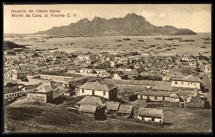
São Vicente (Portuguese for " Saint Vincent") is one of the Barlavento Islands, the northern group within the Cape Verde archipelago in the Atlantic Ocean, off the West African coast. It is located between the islands of Santo Antão and Santa Luzia, with the Canal de São Vicente separating it from Santo Antão. Geography The island is roughly rectangular in shape with an area of . From east to west it measures and from north to south .Cabo Verde, Statistical Yearbook 2015 Instituto Nacional de Estatística The island, of |
Santo Antão, Cape Verde
Santo Antão (Portuguese for " Saint Anthony") is the westernmost island of Cape Verde. At , it is the largest of the Barlavento Islands group, and the second largest island of Cape Verde.Cabo Verde, Statistical Yearbook 2015 Instituto Nacional de Estatística The nearest island is São Vicente to the southeast, separated by the sea channel Canal de São Vicente. Its population was 38,200 in mid 2019, [...More Info...] [...Related Items...] OR: [Wikipedia] [Google] [Baidu] |


