|
Warren Hill, Hooke, Dorset
Warren Hill is a prominent elevation, high, 1 kilometre southwest of the hamlet of Hooke, in the county of Dorset in southern England. Its prominence of means it is listed as one of the Tumps. It is located within the Dorset Downs. The summit is open, as is the hill's eastern flank, but much of the western side of the hill is covered by the woods of Hooke Park. Hooke Court lies just to the northeast. The Jubilee Trail passes Warren Hill just to the south and the Wessex Ridgeway The Wessex Ridgeway is a long-distance footpath in southwest England. It runs from Marlborough in Wiltshire to Lyme Regis in Dorset, via the northern edge of Salisbury Plain and across Cranborne Chase AONB. The footpath was opened in 1994. At ... just to the north. References {{Reflist Hills of Dorset ... [...More Info...] [...Related Items...] OR: [Wikipedia] [Google] [Baidu] |
Lewesdon Hill
Lewesdon Hill is a hill in west Dorset, England. With a maximum elevation of , it is the highest point in Dorset.Muir, Johnny, ''The UK's County Tops'', Milnthorpe: Cicerone, 2011, p. 26. Geography Location Lewesdon Hill stands about 4 km west of Beaminster, 1½ km south of Broadwindsor, 2 miles south of Mosterton, 1½ km west-northwest of Stoke Abbott and 3 km east of another hillfort-topped eminence, Pilsdon Pen. To the south of the hill is the Marshwood Vale and to the north is the valley of the River Axe. Summit Lewesdon is the county top of Dorset. Its summit is an elongated ridge surrounded by beech woods. The actual summit is a low grassy mound at the east end of the ridge.''Lewesdon Hill'' at www.hill-bagging.co.uk. Retrieved 18 Jun 2017. For many years, nearby |
Tump (hill)
The mountains and hills of the British Isles are categorised into various lists based on different combinations of elevation, prominence, and other criteria such as isolation. These lists are used for peak bagging, whereby hillwalkers attempt to reach all the summits on a given list, the oldest being the 282 Munros in Scotland, created in 1891. A height above 2,000 ft, or more latterly 610 m, is considered necessary to be classified as a mountain – as opposed to a hill – in the British Isles. With the exception of Munros, all the lists require a prominence above . A prominence of between (e.g. some Nuttalls and Vandeleur-Lynams), does not meet the International Climbing and Mountaineering Federation (UIAA) definition of an "independent peak", which is a threshold over . Most lists consider a prominence between as a "top" (e.g. many Hewitts and Simms). Marilyns, meanwhile, have a prominence above , with no additional height threshold. They range from small hills to ... [...More Info...] [...Related Items...] OR: [Wikipedia] [Google] [Baidu] |
Dorset
Dorset ( ; archaically: Dorsetshire , ) is a county in South West England on the English Channel coast. The ceremonial county comprises the unitary authority areas of Bournemouth, Christchurch and Poole and Dorset (unitary authority), Dorset. Covering an area of , Dorset borders Devon to the west, Somerset to the north-west, Wiltshire to the north-east, and Hampshire to the east. The county town is Dorchester, Dorset, Dorchester, in the south. After the Local Government Act 1972, reorganisation of local government in 1974, the county border was extended eastward to incorporate the Hampshire towns of Bournemouth and Christchurch. Around half of the population lives in the South East Dorset conurbation, while the rest of the county is largely rural with a low population density. The county has a long history of human settlement stretching back to the Neolithic era. The Roman conquest of Britain, Romans conquered Dorset's indigenous Durotriges, Celtic tribe, and during the Ear ... [...More Info...] [...Related Items...] OR: [Wikipedia] [Google] [Baidu] |
Dorset Downs
The Dorset Downs are an area of chalk downland in the centre of the county Dorset in south west England. The downs are the most western part of a larger chalk formation which also includes (from west to east) Cranborne Chase, Salisbury Plain, Hampshire Downs, Chiltern Hills, North Downs and South Downs.''Uplift, Erosion and Stability: Perspectives on Long-term Landscape Development'' ed. by Smith, Bernard J., Whalley Wilfred B. and Warke Patricia A. (1999), Geological Society Special Publication No. 162, Bath. Accessed on 3 Apr 2013. Physical geography The Dorset Downs are bounded on the north, along the steep[...More Info...] [...Related Items...] OR: [Wikipedia] [Google] [Baidu] |
Ordnance Survey
, nativename_a = , nativename_r = , logo = Ordnance Survey 2015 Logo.svg , logo_width = 240px , logo_caption = , seal = , seal_width = , seal_caption = , picture = , picture_width = , picture_caption = , formed = , preceding1 = , dissolved = , superseding = , jurisdiction = Great BritainThe Ordnance Survey deals only with maps of Great Britain, and, to an extent, the Isle of Man, but not Northern Ireland, which has its own, separate government agency, the Ordnance Survey of Northern Ireland. , headquarters = Southampton, England, UK , region_code = GB , coordinates = , employees = 1,244 , budget = , minister1_name = , minister1_pfo = , chief1_name = Steve Blair , chief1_position = CEO , agency_type = , parent_agency = , child1_agency = , keydocument1 = , website = , footnotes = , map = , map_width = , map_caption = Ordnance Survey (OS) is the national mapping agency for Great Britain. The agency's name indicates its original military purpose (se ... [...More Info...] [...Related Items...] OR: [Wikipedia] [Google] [Baidu] |
Hooke, Dorset
Hooke is a small village and civil parish in the county of Dorset in southern England, situated about northeast of the town of Bridport. It is sited in the valley of the short River Hooke, a tributary of the River Frome, amongst the chalk hills of the Dorset Downs. In the 2011 census the parish had a population of 157. Rampisham Down, the hill immediately northeast of the village, is the site of a transmitter station operated by VT Communications, broadcasting long-range radio signals for clients including BBC World Service. The outskirts of the village are home to Hooke Court and its surrounding parklands. Originally built in 1407 by Humphrey Stafford, the Court was extended in 1609 by the Marquis of Winchester. To the southwest of the village are Warren Hill and the woods of Hooke Park Hooke Park is a 142 hectare woodland in Dorset, South West England located near the town of Beaminster and within the Dorset Area of Outstanding Natural Beauty. The site is designated a ... [...More Info...] [...Related Items...] OR: [Wikipedia] [Google] [Baidu] |
England
England is a country that is part of the United Kingdom. It shares land borders with Wales to its west and Scotland to its north. The Irish Sea lies northwest and the Celtic Sea to the southwest. It is separated from continental Europe by the North Sea to the east and the English Channel to the south. The country covers five-eighths of the island of Great Britain, which lies in the North Atlantic, and includes over 100 smaller islands, such as the Isles of Scilly and the Isle of Wight. The area now called England was first inhabited by modern humans during the Upper Paleolithic period, but takes its name from the Angles, a Germanic tribe deriving its name from the Anglia peninsula, who settled during the 5th and 6th centuries. England became a unified state in the 10th century and has had a significant cultural and legal impact on the wider world since the Age of Discovery, which began during the 15th century. The English language, the Anglican Church, and Engli ... [...More Info...] [...Related Items...] OR: [Wikipedia] [Google] [Baidu] |
Hooke Park
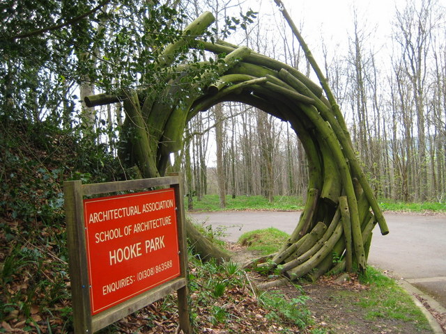
Hooke Park is a 142 hectare woodland in Dorset, South West England located near the town of Beaminster and within the Dorset Area of Outstanding Natural Beauty. The site is designated as ancient woodland and historically comprised a deer hunting estate. An educational campus is located at Hooke Park that was developed by the Parnham Trust following its purchase of the site in 1983. Led by furniture designer John Makepeace a School of Woodland Industries was established that aimed to "research, demonstrate and teach the better use of forest produce". The campus buildings demonstrate experimental timber construction techniques and include works by the late 2015 Pritzker Prize laureate Frei Otto, Edward Cullinan and ABK Architects. In 2002 ownership of Hooke Park was transferred to the Architectural Association School of Architecture The Architectural Association School of Architecture in London, commonly referred to as the AA, is the oldest Independent school (United Kingdom), ... [...More Info...] [...Related Items...] OR: [Wikipedia] [Google] [Baidu] |
Hooke Court
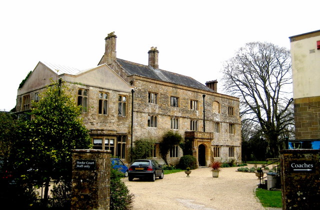
Hooke Court is a 17th-century manor house in the parish of Hooke, Dorset, Hooke in Dorset, England. It is a Grade II* listed building built around the time of the English Civil War. Standing in about of mature park and woodland, Hooke Court is on the outskirts of Hooke, Dorset, Hooke, a village in rural Dorset. It lies at the foot of Warren Hill, Hooke, Dorset, Warren Hill. In the Civil War it was damaged by fire by Roundheads but repaired in 1647 by the Duke of Bolton. There had previously been medieval buildings on the site. Hooke Court was previously a boarding school for boys with educational, emotional or behavioural problems, from 1946 to 1992. Saint Francis School for Boys was run and managed by Society of Saint Francis. Hooke Court is today used as a residential study centre. In 2007 it was featured on the television series ''Time Team'' which attempted to discover the nature of the medieval buildings. See also *River Hooke References External links Hooke Court ... [...More Info...] [...Related Items...] OR: [Wikipedia] [Google] [Baidu] |
Jubilee Trail
{{Unreferenced, date=December 2009 ''Jubilee Trail'' is a novel written by Gwen Bristow, copyrighted in 1950. It follows the adventures of two strong women in the mid-19th century as they travel across the United States to the then-Mexican territory of California. The novel is still in print, with forewords included by Nancy E. Turner and Sandra Dallas. The rights to the book were purchased at great expense by Republic Pictures as a starring vehicle for B movie actress Vera Hrubá Ralston, who was married to the head of studio. ''Jubilee Trail'' was released in 1954. Plot summary The story begins with Garnet Cameron, an 18-year-old young woman from upper-class New York society. Garnet has just graduated from her finishing school and is trying to find a direction for her life now that her schooling is done. That summer, a young man by the name of Oliver Hale comes to New York. He is in town to buy supplies from the estate of Mr. Selkirk, a wealthy murdered man, to bring west with ... [...More Info...] [...Related Items...] OR: [Wikipedia] [Google] [Baidu] |
Wessex Ridgeway
The Wessex Ridgeway is a long-distance footpath in southwest England. It runs from Marlborough in Wiltshire to Lyme Regis in Dorset, via the northern edge of Salisbury Plain and across Cranborne Chase AONB. The footpath was opened in 1994. At Marlborough, the footpath meets the Ridgeway National Trail which continues into Oxfordshire and Buckinghamshire. Two further long-distance footpaths extend to Hunstanton in Norfolk; together, the four paths are referred to as the Greater Ridgeway. Landmarks * Bell Hill * Coney's Castle * Lambert's Castle * Pilsdon Pen * Lewesdon Hill Lewesdon Hill is a hill in west Dorset, England. With a maximum elevation of , it is the highest point in Dorset.Muir, Johnny, ''The UK's County Tops'', Milnthorpe: Cicerone, 2011, p. 26. Geography Location Lewesdon Hill stands about 4&nbs ... * Waddon Hill * Scratchbury Hill External links * * 1994 establishments in England Footpaths in Wiltshire Long-distance footpaths in Dors ... [...More Info...] [...Related Items...] OR: [Wikipedia] [Google] [Baidu] |


