|
Waiheke Island Aerodrome
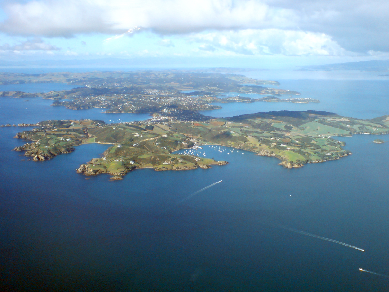
Waiheke Island Aerodrome is a private airport on Waiheke Island, 17 nautical miles northeast of Auckland, New Zealand. General Waiheke Island Aerodrome is situated on the top of a ridge line south of Onetangi Bay and is the only airport on Waiheke Island. It is privately owned and operated and prior permission to land is required. The airport is used primarily for residents of and visitors to Waiheke Island where Waiheke Wings is the only island-based operator. The airfield is also used for medevac from Waiheke Island to Auckland hospitals. The grass runway is positioned on the top of the ridge line with the northerly landing direction preferred due to the uphill slope. As the area features significant changes in topography there is the possibility of tricky crosswinds, sometimes coming from both sides of the runway concurrently. This, along with the local noise sensitivity, is one reason why prior permission to land is required before planning of any trip to the airfield. ... [...More Info...] [...Related Items...] OR: [Wikipedia] [Google] [Baidu] |
Grass
Poaceae () or Gramineae () is a large and nearly ubiquitous family of monocotyledonous flowering plants commonly known as grasses. It includes the cereal grasses, bamboos and the grasses of natural grassland and species cultivated in lawns and pasture. The latter are commonly referred to collectively as grass. With around 780 genera and around 12,000 species, the Poaceae is the fifth-largest plant family, following the Asteraceae, Orchidaceae, Fabaceae and Rubiaceae. The Poaceae are the most economically important plant family, providing staple foods from domesticated cereal crops such as maize, wheat, rice, barley, and millet as well as feed for meat-producing animals. They provide, through direct human consumption, just over one-half (51%) of all dietary energy; rice provides 20%, wheat supplies 20%, maize (corn) 5.5%, and other grains 6%. Some members of the Poaceae are used as building materials (bamboo, thatch, and straw); others can provide a source of biofuel, ... [...More Info...] [...Related Items...] OR: [Wikipedia] [Google] [Baidu] |
Waiheke Island
Waiheke Island (; Māori: ) is the second-largest island (after Great Barrier Island) in the Hauraki Gulf of New Zealand. Its ferry terminal in Matiatia Bay at the western end is from the central-city terminal in Auckland. It is the most populated island in the gulf, with permanent residents. Another estimated 3,400 have second homes or holiday homes on the island. It is New Zealand's most densely populated island, and the third most populated after the North and South Islands. It is the most accessible island in the gulf, with regular passenger and car-ferry services, a helicopter operator based on the island, and other air links. In November 2015, Lonely Planet rated Waiheke Island the fifth-best region in the world to visit in 2016. Geography Overview The island is off the coast of the North Island. It is in length from west to east, varies in width from , and has a surface area of . The coastline is , including of beaches. The port of Matiatia at the western end is ... [...More Info...] [...Related Items...] OR: [Wikipedia] [Google] [Baidu] |
Nautical Mile
A nautical mile is a unit of length used in air, marine, and space navigation, and for the definition of territorial waters. Historically, it was defined as the meridian arc length corresponding to one minute ( of a degree) of latitude. Today the international nautical mile is defined as exactly . The derived unit of speed is the knot, one nautical mile per hour. Unit symbol There is no single internationally agreed symbol, with several symbols in use. * M is used as the abbreviation for the nautical mile by the International Hydrographic Organization. * NM is used by the International Civil Aviation Organization. * nmi is used by the Institute of Electrical and Electronics Engineers and the United States Government Publishing Office. * nm is a non-standard abbreviation used in many maritime applications and texts, including U.S. Government Coast Pilots and Sailing Directions. It conflicts with the SI symbol for nanometre. History The word mile is from the Latin word ... [...More Info...] [...Related Items...] OR: [Wikipedia] [Google] [Baidu] |
Auckland
Auckland (pronounced ) ( mi, Tāmaki Makaurau) is a large metropolitan city in the North Island of New Zealand. The List of New Zealand urban areas by population, most populous urban area in the country and the List of cities in Oceania by population, fifth largest city in Oceania, Auckland has an urban population of about It is located in the greater Auckland Region—the area governed by Auckland Council—which includes outlying rural areas and the islands of the Hauraki Gulf, and which has a total population of . While European New Zealanders, Europeans continue to make up the plurality of Auckland's population, the city became multicultural and Cosmopolitanism, cosmopolitan in the late-20th century, with Asian New Zealanders, Asians accounting for 31% of the city's population in 2018. Auckland has the fourth largest Foreign born, foreign-born population in the world, with 39% of its residents born overseas. With its large population of Pasifika New Zealanders, the city is ... [...More Info...] [...Related Items...] OR: [Wikipedia] [Google] [Baidu] |
New Zealand
New Zealand ( mi, Aotearoa ) is an island country in the southwestern Pacific Ocean. It consists of two main landmasses—the North Island () and the South Island ()—and over 700 smaller islands. It is the sixth-largest island country by area, covering . New Zealand is about east of Australia across the Tasman Sea and south of the islands of New Caledonia, Fiji, and Tonga. The country's varied topography and sharp mountain peaks, including the Southern Alps, owe much to tectonic uplift and volcanic eruptions. New Zealand's capital city is Wellington, and its most populous city is Auckland. The islands of New Zealand were the last large habitable land to be settled by humans. Between about 1280 and 1350, Polynesians began to settle in the islands and then developed a distinctive Māori culture. In 1642, the Dutch explorer Abel Tasman became the first European to sight and record New Zealand. In 1840, representatives of the United Kingdom and Māori chiefs ... [...More Info...] [...Related Items...] OR: [Wikipedia] [Google] [Baidu] |
Onetangi Bay
Onetangi is a settlement on the north coast of Waiheke Island in New Zealand. It has a long white-sand beach fronting onto Onetangi Bay. The name means "Weeping Sands" in the Māori language, and comes from a battle in 1821 during the Musket Wars. The area was subdivided for settlement in 1921. The Museum of Waiheke opened in Onetangi in 1990. The beachfront is a popular area for holiday-makers and locals whom enjoy the temperate climate and fishing in the area. The bay also contains two restaurants; ''Charlie Farley’s'' and ''Three Seven Two''. Demographics Onetangi covers and had an estimated population of as of with a population density of people per km2. Onetangi had a population of 1,302 at the 2018 New Zealand census, an increase of 168 people (14.8%) since the 2013 census, and an increase of 147 people (12.7%) since the 2006 census. There were 513 households, comprising 657 males and 645 females, giving a sex ratio of 1.02 males per female. The median age was ... [...More Info...] [...Related Items...] OR: [Wikipedia] [Google] [Baidu] |
Medevac
Medical evacuation, often shortened to medevac or medivac, is the timely and efficient movement and en route care provided by medical personnel to wounded being evacuated from a battlefield, to injured patients being evacuated from the scene of an accident to receiving medical facilities, or to patients at a rural hospital requiring urgent care at a better-equipped facility using medically equipped air ambulances, especially helicopters. Examples include civilian EMS vehicles, civilian aeromedical helicopter services, and military air ambulances. This term also covers the transfer of patients from the battlefield to a treatment facility or from one treatment facility to another by medical personnel, such as from a local hospital to a trauma center. History The first medical transport by air was recorded in Serbia in the autumn of 1915 during First World War. One of the ill soldiers in that first medical transport was Milan Rastislav Štefánik, a Slovak pilot-volunteer who was ... [...More Info...] [...Related Items...] OR: [Wikipedia] [Google] [Baidu] |
Crosswind
A crosswind is any wind that has a perpendicular component to the line or direction of travel. This affects the aerodynamics of many forms of transport. Moving non-parallel to the wind's direction creates a crosswind component on the object and thus increasing the apparent wind on the object; such use of cross wind travel is used to advantage by sailing craft, kiteboarding craft, power kiting, etc. On the other side, crosswind moves the path of vehicles sideways and can be a hazard. Definition When winds are not parallel to or directly with/against the line of travel, the wind is said to have a crosswind ''component''; that is, the force can be separated into two vector components: * the headwind or tailwind component in the direction of motion, * the crosswind component perpendicular to the former. A vehicle behaves as though it is directly experiencing a lateral effect of the magnitude of the crosswind component only. The crosswind component is computed by multiplying the win ... [...More Info...] [...Related Items...] OR: [Wikipedia] [Google] [Baidu] |
List Of Airports In New Zealand ...
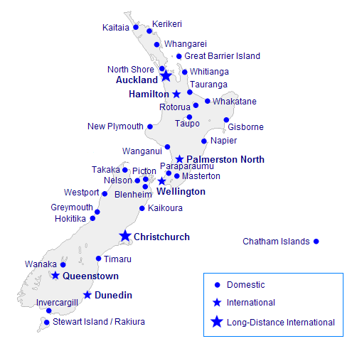
This is a list of airports in New Zealand, sorted by location. List Airport names shown in bold indicate the airport has scheduled passenger service on commercial airlines. The cities shown in bold are international. See also * Transport in New Zealand * List of busiest airports in New Zealand * List of airports by ICAO code: N#NZ - New Zealand * List of former Royal New Zealand Air Force stations References Great Circle Mapper- ICAO and IATA codes * * External links AIP New Zealand- airport and heliport charts {{Oceania in topic, List of airports in New Zealand Airports in New Zealand Airports New Zealand New Zealand ( mi, Aotearoa ) is an island country in the southwestern Pacific Ocean. It consists of two main landmasses—the North Island () and the South Island ()—and over 700 smaller islands. It is the sixth-largest island count ... [...More Info...] [...Related Items...] OR: [Wikipedia] [Google] [Baidu] |
List Of Airlines Of New Zealand ...
This is a list of airlines that have an Air Operator Certificate issued by the Civil Aviation Authority of New Zealand. Scheduled airlines Charter airlines Cargo airlines See also *List of defunct airlines of New Zealand *List of airlines *List of general aviation operators of New Zealand References External links * {{Oceania topic, List of airlines of Airlines New Zealand Airlines New Zealand New Zealand ( mi, Aotearoa ) is an island country in the southwestern Pacific Ocean. It consists of two main landmasses—the North Island () and the South Island ()—and over 700 smaller islands. It is the sixth-largest island count ... [...More Info...] [...Related Items...] OR: [Wikipedia] [Google] [Baidu] |
Transport In New Zealand
Transport in New Zealand, with its mountainous topography and a relatively small population mostly located near its long coastline, has always faced many challenges. Before Europeans arrived, Māori either walked or used watercraft on rivers or along the coasts. Later on, European shipping and railways revolutionised the way of transporting goods and people, before being themselves overtaken by road and air, which are nowadays the dominant forms of transport. However, bulk freight still continues to be transported by coastal shipping and by rail transport, and there are attempts to (re)introduce public transport as a major transport mode in the larger population centres. Historically very car-dependent, transport funding in New Zealand is still heavily dominated by money for road projects–in 2010 the government proposed to spend $21 billion on roading infrastructure after 2012, yet only $0.7 billion on other transport projects (public transport, walking and c ... [...More Info...] [...Related Items...] OR: [Wikipedia] [Google] [Baidu] |
Airports In New Zealand ...
This is a list of airports in New Zealand, sorted by location. List Airport names shown in bold indicate the airport has scheduled passenger service on commercial airlines. The cities shown in bold are international. See also * Transport in New Zealand * List of busiest airports in New Zealand * List of airports by ICAO code: N#NZ - New Zealand * List of former Royal New Zealand Air Force stations References Great Circle Mapper- ICAO and IATA codes * * External links AIP New Zealand- airport and heliport charts {{Oceania in topic, List of airports in New Zealand Airports in New Zealand Airports New Zealand New Zealand ( mi, Aotearoa ) is an island country in the southwestern Pacific Ocean. It consists of two main landmasses—the North Island () and the South Island ()—and over 700 smaller islands. It is the sixth-largest island count ... [...More Info...] [...Related Items...] OR: [Wikipedia] [Google] [Baidu] |

_p225_AUCKLAND%2C_NEW_ZEALAND.jpg)
.jpg)


