|
Wuustwezel
Wuustwezel () is a municipality located in the north of the Belgian province of Antwerp. The municipality as it is now originated in 1977, when Wuustwezel merged with the municipality of Loenhout. It now consists of three major villages, Wuustwezel proper, Gooreind and Loenhout, and two minor hamlets, Braken and Sterbos. In 2021, Wuustwezel had a total population of 21,346. The total area is 89.43 km2. The Azencross Loenhout is a December cyclo-cross competition, which is part of the BPost Bank Trophy. The largest ''bloemencorso'' (flower parade) of Belgium is held in Loenhout. All the villages and hamlets in the area compete who has the most beautiful floats made out of flowers. Its neighbouring municipalities are Zundert in the Netherlands, Kalmthout, Kapellen, Brasschaat, Brecht and Hoogstraten Hoogstraten () is a municipality located in the Belgian province of Antwerp. The municipality comprises Hoogstraten, Meer, Meerle, Meersel-Dreef, Minderhout and Wortel (Mee ... [...More Info...] [...Related Items...] OR: [Wikipedia] [Google] [Baidu] |
Loenhout
Loenhout is a village and '' deelgemeente'' (sub-municipality) of the municipality of Wuustwezel in the province of Antwerp, Belgium. The village is located near the Dutch border, and about north-east of the city of Antwerp. History The area around Loenhout used to contain two '' heerlijkheden'' under the same Lord, but one was a fief of Hoogstraten while the other belonged to the Duchy of Brabant. Loenhout became a parish in 13th century, and was awarded to the St. Bernard's Abbey of Hemiksen in 1277. The Dutch Revolt in the late 16th century resulted in the destruction of the castle and a near depopulation of the area. In the 18th century, during the rule of Maria Theresa of Naples and Sicily, the wilderness was cultivated, and Loenhout became an agricultural community specialising in livestock. Loenhout was an independent municipality until 1977 when it was merged with Wuustwezel. Nature and landscape Loenhout is located in the North Campine, a region with a poor ... [...More Info...] [...Related Items...] OR: [Wikipedia] [Google] [Baidu] |
Azencross
The Azencross is a cyclo-cross race held in Loenhout village, Wuustwezel, Belgium, which until 2021 was part of the DVV Trophy. Past winners References Men's resultsWomen's results UCI Cyclo-cross World Cup Cycle races in Belgium Cyclo-cross races Recurring sporting events established in 1984 1984 establishments in Belgium Sport in Antwerp Province Wuustwezel {{Belgium-cycling-race-stub ... [...More Info...] [...Related Items...] OR: [Wikipedia] [Google] [Baidu] |
Zundert
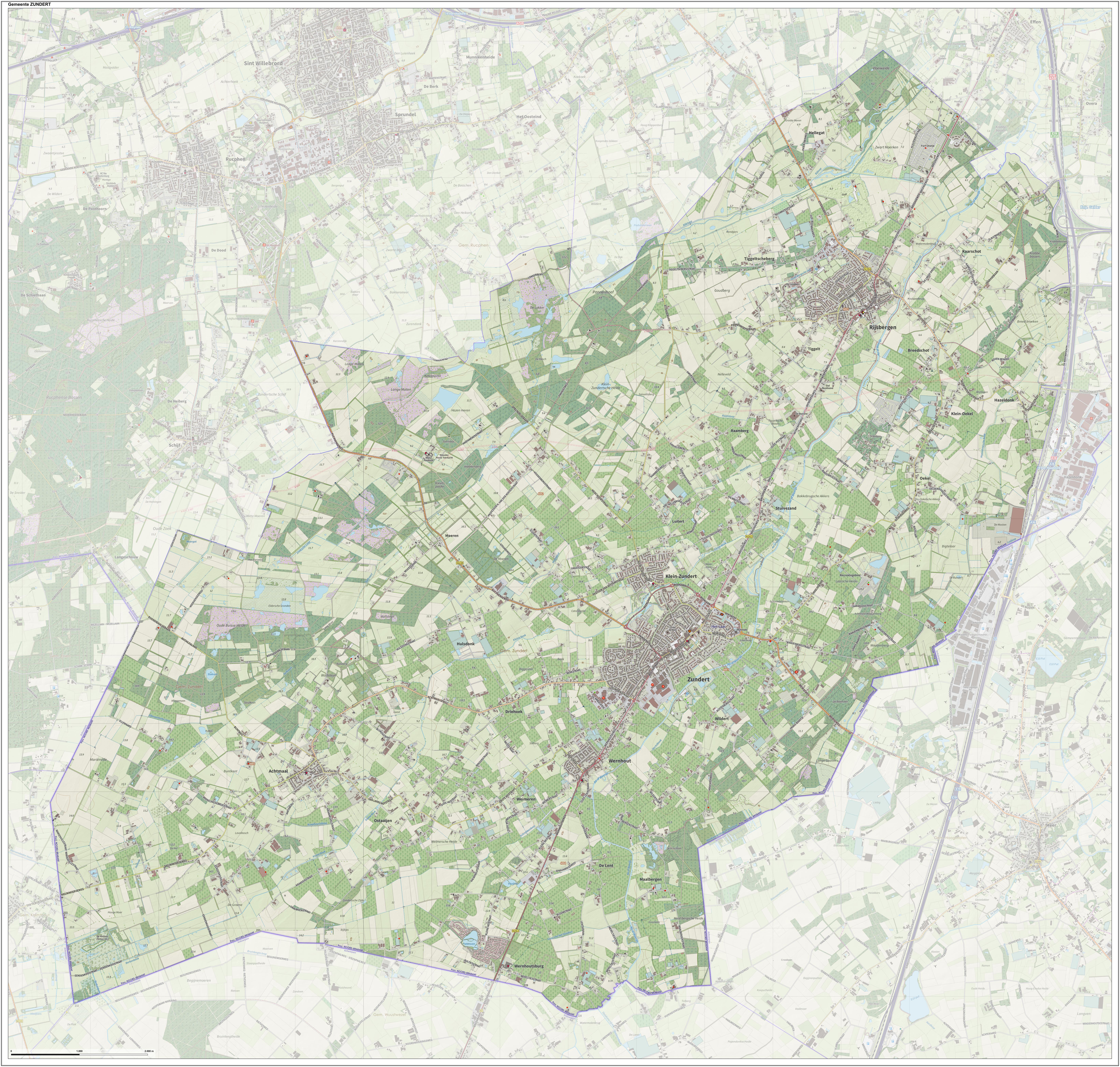
Zundert () is a Municipalities of the Netherlands, municipality and town in the south of the Netherlands bordering Belgium, in the province of North Brabant. Zundert is the birthplace of Post-impressionism, post-impressionist painter Vincent van Gogh. History The name of Zundert is first mentioned in a certificate dating from 1157, in which the Prince-Bishopric of Liège, Bishop of Liege confirms a donation from the place "Sunderda". This Sunderda actually relates to the current settlement of Klein-Zundert (Dutch for Small Zundert), one of the first settlements in the area. The local monks, besides their religious labour, were also involved in clearing the land, that was still rough territory, filled with swamps, peats and heath fields. The monks also assisted in improving agricultural methods. Zundert is still surrounded by a rural environment with nature areas, one of them is the "Buissche Heide", a heath area used for recreation and walking. The Kalmthoutse Heide, across th ... [...More Info...] [...Related Items...] OR: [Wikipedia] [Google] [Baidu] |
Antwerp Province
) , native_name_lang = nl , settlement_type = Province of Belgium , image_flag = Flag of Antwerp.svg , flag_size = , image_shield = Wapen van de provincie Antwerpen.svg , shield_size = 120px , image_map = Provincie Antwerpen in Belgium.svg , coordinates = , subdivision_type = Country , subdivision_name = , subdivision_type1 = Region , subdivision_name1 = , seat_type = Capital , seat = Antwerp , leader_title = Governor , leader_name = Cathy Berx ( CD&V) , area_total_km2 = 2,876 , area_footnotes = , population_total = 1,857,986 , population_footnotes = , population_as_of = 1 January 2019 , population_density_km2 = auto , blank_name_sec2 = HDI (2019) , blank_info_sec2 = 0.945 · 4th of 11 , website = Antwerp Provi ... [...More Info...] [...Related Items...] OR: [Wikipedia] [Google] [Baidu] |
Brasschaat
Brasschaat () is a municipality located in Flanders, one of the three regions of Belgium, and in the Flemish province of Antwerp. The municipality only comprises the town of Brasschaat proper. In November 2006, Brasschaat won the LivCom-Award 2006 for the most livable municipality in the world. History Origins The history of Brasschaat started with Celtic settlements. The Gallic tribe of the Belgae displaced them and were in turn conquered by the Romans, who built a major road in the area. After the Germanic invasions in the 3rd and 4th century, the whole region was Christianized. In the Middle Ages the little river Laar, flowing through the woods of the municipality, served as a natural bordermark between the Bishopric of Liège and the Bishopric of Cambrai. Middle Ages The first mention of ''Breesgata'', sometimes also spelt ''Brexgata'', dates from 1269. In 1482, a convent of nuns was founded here, traces of which can still be seen today. The village of Brasschaat be ... [...More Info...] [...Related Items...] OR: [Wikipedia] [Google] [Baidu] |
Antwerp (province)
) , native_name_lang = nl , settlement_type = Province of Belgium , image_flag = Flag of Antwerp.svg , flag_size = , image_shield = Wapen van de provincie Antwerpen.svg , shield_size = 120px , image_map = Provincie Antwerpen in Belgium.svg , coordinates = , subdivision_type = Country , subdivision_name = , subdivision_type1 = Region , subdivision_name1 = , seat_type = Capital , seat = Antwerp , leader_title = Governor , leader_name = Cathy Berx ( CD&V) , area_total_km2 = 2,876 , area_footnotes = , population_total = 1,857,986 , population_footnotes = , population_as_of = 1 January 2019 , population_density_km2 = auto , blank_name_sec2 = HDI (2019) , blank_info_sec2 = 0.945 · 4th of 11 , website = Antwerp Provi ... [...More Info...] [...Related Items...] OR: [Wikipedia] [Google] [Baidu] |
Hoogstraten
Hoogstraten () is a municipality located in the Belgian province of Antwerp. The municipality comprises Hoogstraten, Meer, Meerle, Meersel-Dreef, Minderhout and Wortel (Meersel-Dreef includes the northernmost point in Belgium). Hoogstraten (originally ''Hoogstraeten'') has a population of over 20,000, and lies in Flanders at the northern border of Belgium within an enclave surrounded on three sides by the Netherlands. Today, about 15% percent of the population consists of Dutch people. The town is named after the ''hoge straat'' or "high road" – a military highway that linked the old towns of Antwerp and 's-Hertogenbosch. In the town's early days, little trade existed. Villages and towns produced just enough for their own support, with little or no surplus to be 'sold' to other areas. Thus, most travelers along this high road were soldiers and armies. Today Hoogstraten is internationally known for its strawberries. Veiling Hoogstraten (auction) is one of the largest of the B ... [...More Info...] [...Related Items...] OR: [Wikipedia] [Google] [Baidu] |
Brecht, Belgium
Brecht () is a municipality located in the Belgian province of Antwerp. The municipality comprises the towns of Brecht proper, Sint-Job-in-'t-Goor and . In 2021, Brecht had a total population of 29,809. The total area is 90.84 km². Brecht is a fast-growing municipality in the north of the Antwerp province, near the Dutch border. Noorderkempen, a railway station on the HSL 4, opened on 15 June 2009. Images Image:Brecht kerk.jpg, Sint-Michielskerk in Brecht File:Groot Schietveld 001.jpg, Nature reserve Groot Schietveld File:A Brecht, Stenen molen, bergmolen, kettingkruier 00W.JPG, Windmill in Brecht Notable people * Jan van der Noot (1539–1595), writer and poet, born in Brecht * Leonard Lessius (1554-1623), moral theologian, born in Brecht * Walter Van Beirendonck (1957-), fashion designer and one of the Antwerp Six * Jean Kockerols (1958-), Roman Catholic bishop Climate See also * Brecht Abbey Eugen Berthold Friedrich Brecht (10 February 1898 – 14 August ... [...More Info...] [...Related Items...] OR: [Wikipedia] [Google] [Baidu] |
Arrondissement Of Antwerp
The Arrondissement of Antwerp (; ) is one of the three administrative arrondissements in Antwerp Province, Belgium. It is both an administrative and a judicial arrondissement. The territory of the Judicial Arrondissement of Antwerp coincides with that of the Administrative Arrondissement of Antwerp. History The Arrondissement of Antwerp was created in 1800 as the first arrondissement in the Department of Deux-Nèthes (). It originally comprised the cantons of Antwerp, Boom, Berchem, Brecht, Ekeren and Zandhoven. In 1923, the then municipalities of Burcht and Zwijndrecht (Burcht was merged into Zwijndrecht in 1977 to form the present-day municipality of Zwijndrecht) in the Arrondissement of Sint-Niklaas were added to the arrondissement. Municipalities The Administrative Arrondissement of Antwerp consists of the following municipalities: * Aartselaar * Antwerp * Boechout * Boom * Borsbeek * Brasschaat * Brecht * Edegem * Essen * Hemiksem * Hove * Kalmthout * Kapellen * Konti ... [...More Info...] [...Related Items...] OR: [Wikipedia] [Google] [Baidu] |
Kalmthout
Kalmthout () is a municipality in the Belgian province of Antwerp. The municipality comprises the villages of Kalmthout, Achterbroek, Heide, and Nieuwmoer. In 2021, Kalmthout had a population of 19,020. The total area is . In addition to Kalmthout itself, the municipality also contains the communities of Dorp-Heuvel, Heide, Achterbroek, and Nieuwmoer. The Arboretum Kalmthout is one of Belgium's most beautiful botanical gardens. The Kalmthoutse Heide is a nature reserve of nearly spanning the border between Belgium and the Netherlands. Sightseeing The "Kalmthoutse Heide" is a big natural park in Kalmthout. It is open to the public and has more than 15 different routes that can run for 10s of kilometers. The first synagogue outside of a city in Belgium was built in 1928 on Leopoldstraat in the village of Heide. This pre-dates the Catholic church St. Jozef's and can be seen on the local walking tour. The Jewish community played an important part in local history, with the first ... [...More Info...] [...Related Items...] OR: [Wikipedia] [Google] [Baidu] |
Kapellen, Belgium
Kapellen (, old spelling: ''Cappellen'') is a municipality in the Belgian province of Antwerp. The municipality lies in the Campine in the northern part of the province. Kapellen consists only of the town of Kapellen proper. In 2021, Kapellen had a total population of 27,157. The total area is 37.11 km². Kapellen consists out of multiple neighbourhoods, Kapellen Center, the eastern part of Putte, Kapellenbos, Hoogboom and Zilverenhoek. A number of neighbourhoods in Kapellen have a residential character and are characterized by their villaparcs, exclusive landhouses, and beautiful castles. Many who flee the always busy town enjoy Kapellen's peaceful nature. The town's football club is R. Cappellen F.C. and has played at the national level for many years. History The communities that are now part of Kapellen date back to the 13th century. Hoogboom can be found as Hobonia on documents from 1267. Hoghescote, the current center can be seen 10 years after Hoogboom in Ertbra ... [...More Info...] [...Related Items...] OR: [Wikipedia] [Google] [Baidu] |


.jpg)
