|
Wisconsin Highway 47
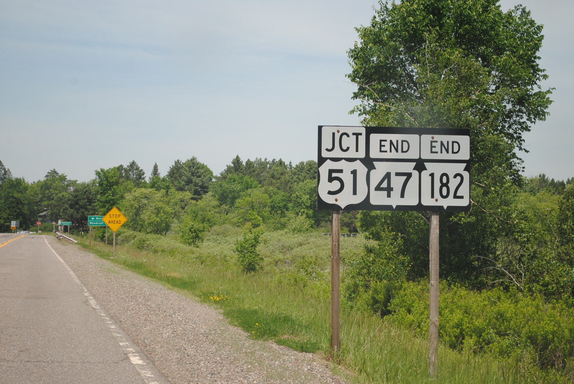
State Trunk Highway 47 (often called Highway 47, STH-47 or WIS 47) is a state highway in the northeastern and northern parts of the US state of Wisconsin that runs in a diagonal northwest–southeast from Menasha to Manitowish. Route description The southern terminus of WIS 47 is at WIS 114 at the corner of Third and De Pere streets in Menasha. Of the route, about are cosigned with other highways. From south to north, WIS 47 is aligned with WIS 29 from south of Bonduel to south of Shawano, WIS 55 from south of Bonduel to Keshena. After a solo segment, WIS 47 follows US Highway 45 (US 45) from south of Antigo to Monico and US 8 from Monico to Rhinelander. The northern terminus of WIS 47 is a combined terminus with WIS 182 at US 51 in Manitowish. History At its inception, WIS 47 ran from WIS 15 in Appleton to WIS 29 in Bonduel. In 1919, the highway was expanded north to Antigo, where it en ... [...More Info...] [...Related Items...] OR: [Wikipedia] [Google] [Baidu] |
Menasha, Wisconsin
Menasha () is a city in Calumet and Winnebago counties in the U.S. state of Wisconsin. The population was 18,268 at the 2020 census. Of this, 15,144 were in Winnebago County, and 2,209 were in Calumet County. The city is located mostly in Winnebago County; only a small portion is in the Town of Harrison in Calumet County. Doty Island is located partially in Menasha. The city's name comes from the Winnebago word meaning "thorn" or "island". In the Menominee language, it is known as ''Menāēhsaeh'', meaning "little island". Menasha is home to the Barlow Planetarium and Weis Earth Science Museum, both housed at the University of Wisconsin-Oshkosh, Fox Cities Campus. Geography Menasha is located at (44.2129, −88.4362). According to the United States Census Bureau, the city has a total area of , of which, is land and is water. Demographics Menasha is a city in the Appleton–Oshkosh–Neenah CSA, a Combined Statistical Area which includes the Appleton (Calumet and Outagam ... [...More Info...] [...Related Items...] OR: [Wikipedia] [Google] [Baidu] |
Minocqua (CDP), Wisconsin
Minocqua is a census-designated place located in the town of Minocqua, Oneida County, Wisconsin, United States. Minocqua is located on a peninsula on Minocqua Lake, northwest of Rhinelander. The community is served by U.S. Route 51. Minocqua has a post office with ZIP code 54548. As of the 2010 census, its population is 451. Images File:Minocqua Wisconsin Sign Looking north US51.jpg, Minocqua sign File:Minocqua Wisconsin Welcome Sign.jpg, Welcome sign File:Lake Minocqua Wisconsin Bridge in the Island City.jpg, Bridge over Lake Minocqua Lake Minocqua is a freshwater natural drainage lake in northern Oneida County, Wisconsin. It is 1360 acres (5.5 km²) in area, with an average depth of 23 feet (7 m) and a maximum depth of 60 feet (18.3 m). The name ... in Minocqua References External links Census-designated places in Oneida County, Wisconsin Census-designated places in Wisconsin {{OneidaCountyWI-geo-stub ... [...More Info...] [...Related Items...] OR: [Wikipedia] [Google] [Baidu] |
Langlade (community), Wisconsin
Langlade is an unincorporated community located in the town of Wolf River in Langlade County Langlade County is a county located in the U.S. state of Wisconsin. As of the 2020 census, the population was 19,491. Its county seat is Antigo. History Langlade County was created on March 3, 1879, as New County. It was renamed Langlade Cou ..., Wisconsin, United States. It is located at the intersection of Wisconsin Highway 55 and Wisconsin Highway 64. The Langlade post office was established in June 1873 by its first postmaster, Charles H. Lazelere. The community is named for Charles Michel de Langlade, who established a trading post in the 1740s. References Unincorporated communities in Langlade County, Wisconsin Unincorporated communities in Wisconsin {{LangladeCountyWI-geo-stub ... [...More Info...] [...Related Items...] OR: [Wikipedia] [Google] [Baidu] |
Navarino (CDP), Wisconsin
Navarino is an unincorporated community located in the town of Navarino, Shawano County, Wisconsin, United States. Navarino is located on Wisconsin Highway 156 north-northwest of Nichols, in section 25 of the town. As of the 2010 census, its population is 177. For statistical purposes, the United States Census Bureau has defined Navarino as a census-designated place A census-designated place (CDP) is a concentration of population defined by the United States Census Bureau for statistical purposes only. CDPs have been used in each decennial census since 1980 as the counterparts of incorporated places, su ... (CDP). In the 1920s and earlier, the community which makes up the CDP was known as Galesburg. References Census-designated places in Shawano County, Wisconsin Census-designated places in Wisconsin {{ShawanoCountyWI-geo-stub ... [...More Info...] [...Related Items...] OR: [Wikipedia] [Google] [Baidu] |
Appleton, Wisconsin
Appleton ( mez, Ahkōnemeh) is a city in Outagamie, Calumet, and Winnebago counties in the U.S. state of Wisconsin. One of the Fox Cities, it is situated on the Fox River, southwest of Green Bay and north of Milwaukee. Appleton is the county seat of Outagamie County. As of the 2020 Census it had a population of 75,644, making it the sixth largest city in Wisconsin. Appleton is a part of the Fox Cities metropolitan area, the third largest in the state behind Milwaukee and Madison. Appleton serves as the heart of the Fox River Valley, which is home to Lawrence University, the Fox Cities Exhibition Center, Fox Cities Performing Arts Center, Fox River Mall, Neuroscience Group Field at Fox Cities Stadium, Appleton International Airport, and the Valley's two major hospitals: St. Elizabeth Hospital and ThedaCare Regional Medical Center–Appleton. It also hosts regional events such as Octoberfest and the Mile of Music. History Native American history The territor ... [...More Info...] [...Related Items...] OR: [Wikipedia] [Google] [Baidu] |
Wisconsin Highway 15
State Trunk Highway 15 (STH-15, commonly known as Highway 15 or WIS 15) is a state highway in Outagamie County in the US state of Wisconsin that runs east–west and provides a shortcut to Appleton from U.S. Highway 45 (US 45) for travelers inbound from points north and west. Most of WIS 15 was once part of US 45, which was redirected south of New London to bypass Appleton and provide direct access to Oshkosh and points south. Route description WIS 15 begins at the junction of US 45 and County Trunk Highway T (CTH-T) in the Town of Hortonia (just southeast of New London) as a two-lane road and heads southeast to Hortonville. The route then continues southeast into Greenville where it becomes a multilane expressway just northwest of the unincorporated community. The highway intersects WIS 76 in Greenville then continues southeast for before turning east at the junction with CTH-CB. WIS 15 then junctions with US 41 where it ends and No ... [...More Info...] [...Related Items...] OR: [Wikipedia] [Google] [Baidu] |
Wisconsin Highway 182
State Trunk Highway 182 (often called Highway 182, STH-182 or WIS 182) is a state highway in Price and Iron counties in northwestern Wisconsin, United States, that runs east–west from Park Falls to Manitowish. Route description WIS 182 begins at a signal–controlled intersection with Wisconsin Highway 13 (WIS 13/South 4th Avenue) in western downtown Park Falls. (From the intersection the city street continues west as 1st Street South for one block before ending at South 5th Avenue. WIS 13 heads north as South 4th Avenue, but quickly becomes North 4th Avenue, toward Butternut, Mellen, and Ashland. WIS 13 heads south as South 4th Avenue toward Fifield, Phillips, and Prentice.) For its entire length, WIS 182 is a two-lane road. From its western terminus, WIS 182 heads east as 1st Street South for about before crossing over the Flambeau River. East of the river the road is signed as Birch Street. Roughly after the ... [...More Info...] [...Related Items...] OR: [Wikipedia] [Google] [Baidu] |
Keshena, Wisconsin
Keshena ( mez, Kesīqnæh) is a census-designated place (CDP) in and the county seat of Menominee County, Wisconsin, United States. Located on the Menominee Indian Reservation, it had a population of 1,257 at the 2020 census. Keshena was named for an Indian chief; the Menominee name is ''Kesīqnaeh'' which means "Swift Flying". Geography Keshena is located at (44.877932, -88.628781). According to the United States Census Bureau, the CDP has a total area of 8.5 square miles (21.9 km2), of which 99.88% is land and 0.12% is water. Demographics 2020 census As of the census of 2020, the population was 1,257. The population density was . There were 364 housing units at an average density of . The racial makeup of the cdp was 96.3% Native American, 2.3% White, 0.2% Black or African American, 0.1% Asian, 0.1% Pacific Islander, 0.1% from other races, and 1.0% from two or more races. Ethnically, the population was 2.8% Hispanic or Latino of any race. 2000 census As of ... [...More Info...] [...Related Items...] OR: [Wikipedia] [Google] [Baidu] |
Wisconsin Highway 55
State Trunk Highway 55 (often called Highway 55, STH-55, or WIS 55) is a state highway in Wisconsin, United States. It travels south-to-north in the northeastern part of Wisconsin from an intersection with U.S. Route 151 (US 151) approximately north of Brothertown, near the eastern shore of Lake Winnebago in Calumet County, to the Michigan state line at the Brule River approximately northeast of Nelma in Forest County, where it connects to M-73. Route description Along its route, STH-55 serves Kaukauna, Shawano, the Menominee Indian Reservation, Crandon, and the Nicolet side of the Chequamegon-Nicolet National Forest. History A new roundabout was opened at the intersection of WIS 55 and US 10 between Sherwood and Kaukauna in the autumn of 2009. Another roundabout recently opened at the busy intersection of WIS 55 and WIS 114 approximately west of Sherwood, Wisconsin Sherwood is a village in Calumet County, Wisconsin, Un ... [...More Info...] [...Related Items...] OR: [Wikipedia] [Google] [Baidu] |
Shawano, Wisconsin
Shawano (pronounced SHAW-no) is a city in Shawano County, Wisconsin, United States. The population was 9,305 at the 2010 census. It is the county seat of Shawano County. Geography According to the United States Census Bureau, the city has a total area of , of which, is land and is water. Demographics 2010 census As of the census of 2010, there were 9,305 people, 3,960 households, and 2,299 families residing in the city. The population density was . There were 4,309 housing units at an average density of . The racial makeup of the city was 82.4% White, 0.7% African American, 12.3% Native American, 0.4% Asian, 0.1% Pacific Islander, 1.2% from other races, and 2.8% from two or more races. Hispanic or Latino of any race were 3.1% of the population. There were 3,960 households, of which 28.9% had children under the age of 18 living with them, 40.7% were married couples living together, 12.6% had a female householder with no husband present, 4.8% had a male householder with ... [...More Info...] [...Related Items...] OR: [Wikipedia] [Google] [Baidu] |
Bonduel, Wisconsin
Bonduel is a village in Shawano County, Wisconsin, United States. The population was 1,478 at the 2010 census. History As founded, the community did not have an officially agreed upon name. Some early news reports called it Hartland Corners, presumably in reference to the surrounding town, named Hartland. The name Bonduel was not established for the community until an application for a post office was made in 1864, at which point "Hartland" was rejected as already being in use as a village name in Wisconsin. Therefore, the village was named Bonduel when the post office was created. The village is named after a Jesuit missionary, the Rev. Florimond Bonduel, who served Wisconsin parishes and who worked with the Menominee Indians, helping them settle on their newly created reservation in 1853. Bonduel incorporated as a village in 1916. Prior to this time, administrative affairs for the community were managed by the surrounding town of Hartland. In 1964 attempts by the National F ... [...More Info...] [...Related Items...] OR: [Wikipedia] [Google] [Baidu] |


