|
Wingan Inlet
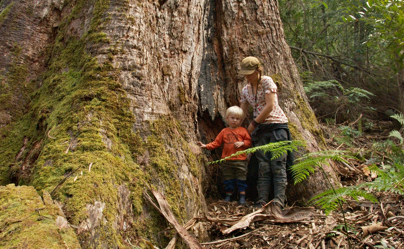
Wingan Inlet is an inlet within the Croajingolong National Park, in the East Gippsland region of Victoria, Australia. Features and location The inlet covers a surface area of and is fed by the Wingan River and provides outflow to the Tasman Sea. It features a ranger-managed camping ground, about an hour's drive from the nearest town, Cann River, along a rough stretch of dirt road. The inlet and its surrounds are home to many species of marine life, including crabs, Sydney rock oysters and other shellfish, as well as birds and small mammals. Paralysis ticks, Lace Monitors and snakes are common. The Wingan Point headland is located a few metres away from the inlet mouth. History Aboriginal history The traditional custodians of the land surrounding Wingan Inlet are the Australian Aboriginal Bidawal and Nindi-Ngudjam Ngarigu Monero peoples. European discovery Wingan Inlet is of historical significance; James Cook clearly recorded the existence of the Inlet on his chart - w ... [...More Info...] [...Related Items...] OR: [Wikipedia] [Google] [Baidu] |
East Gippsland
East Gippsland is the eastern region of Gippsland, Victoria, Australia covering 31,740 square kilometres (14%) of Victoria. It has a population of 80,114. Australian Bureau of Statistics2006 Census Community Profile Series: East Gippsland (Statistical Division). Released at 29/02/2008. LOCATION CODE: 250 STATE: VIC/ref> History The Shire of East Gippsland, also called Far East Gippsland, covers two-thirds (66%) of East Gippsland's area and holds half (50%) of its population. Australian Bureau of Statistics2006 Census. Community Profile Series: East Gippsland Shire (Statistical Subdivision). Released at 29/02/2008. LOCATION CODE: 25005 STATE: VIC/ref> The Shire of East Gippsland is confusingly also referred to simply as East Gippsland. It excludes the Shire of Wellington (Central Gippsland). This article (currently) refers mainly to "Far East Gippsland". East Gippsland's major towns include, from west to east, Bairnsdale (the largest town and administrative centre), Paynesville ... [...More Info...] [...Related Items...] OR: [Wikipedia] [Google] [Baidu] |
Ixodes Holocyclus
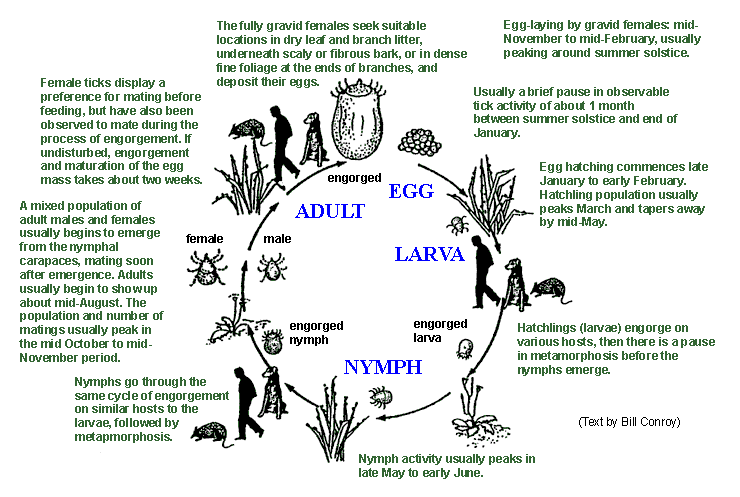
''Ixodes holocyclus'', commonly known as the Australian paralysis tick, is one of about 75 species in the Australian tick fauna and is considered the most medically important. It can cause paralysis by injecting neurotoxins into its host. It is usually found in a 20-kilometre wide band following the eastern coastline of Australia. Within this range ''Ixodes holocyclus'' is the tick most frequently encountered by humans and their pets. As this area also contains Australia's most densely populated regions, bites on people, pets and livestock are relatively common. Paralysis ticks are found in many types of habitat particularly areas of high rainfall such as wet sclerophyll forest and temperate rainforest. The natural hosts for the paralysis tick include koalas, bandicoots, possums and kangaroos. Common names The use of common names has led to many colloquial expressions for ''Ixodes holocyclus''. The most generally accepted name used within Australia is ''Australian paralysis tick ... [...More Info...] [...Related Items...] OR: [Wikipedia] [Google] [Baidu] |
Sydney Cove
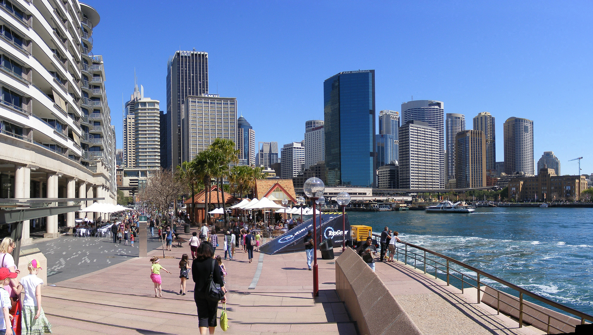
Sydney Cove (Eora: ) is a bay on the southern shore of Sydney Harbour, one of several harbours in Port Jackson, on the coast of Sydney, New South Wales. Sydney Cove is a focal point for community celebrations, due to its central Sydney location between the Sydney Opera House and the Sydney Harbour Bridge. It is also one of the main congregation points for Sydney New Year's Eve. History The Eora name for Sydney Cove was recorded by several early settlers of the First Fleet variously spelt as Warrane, War-ran, Warrang and Wee-rong. The spot is of great significance, as the first meeting place between Eora people and Europeans. Before colonisation of the area, Eora men speared fish from the shoreline, and women line-fished from their ' (canoes). Sydney Cove was named after the British Home Secretary, the 1st Baron Sydney (who was later created 1st Viscount Sydney in 1789). It was the site chosen by Captain Arthur Phillip, RN between 21 and 23 January 1788 for the British p ... [...More Info...] [...Related Items...] OR: [Wikipedia] [Google] [Baidu] |
James Cook
James Cook (7 November 1728 Old Style date: 27 October – 14 February 1779) was a British explorer, navigator, cartographer, and captain in the British Royal Navy, famous for his three voyages between 1768 and 1779 in the Pacific Ocean and to New Zealand and Australia in particular. He made detailed maps of Newfoundland prior to making three voyages to the Pacific, during which he achieved the first recorded European contact with the eastern coastline of Australia and the Hawaiian Islands, and the first recorded circumnavigation of New Zealand. Cook joined the British merchant navy as a teenager and joined the Royal Navy in 1755. He saw action in the Seven Years' War and subsequently surveyed and mapped much of the entrance to the St. Lawrence River during the siege of Quebec, which brought him to the attention of the Admiralty and the Royal Society. This acclaim came at a crucial moment for the direction of British overseas exploration, and it led to his commission in ... [...More Info...] [...Related Items...] OR: [Wikipedia] [Google] [Baidu] |
Ngarigo People
The Ngarigo People (also spelt Garego, Ngarego, Ngarago, Ngaragu, Ngarigu, Ngarrugu or Ngarroogoo) are Aboriginal Australian people of southeast New South Wales, whose traditional lands also extend around the present border with Victoria. Language Ngarigu has been classified by linguist Robert Dixon as one of two Aboriginal Australian languages of the Southern New South Wales Group, the other being Ngunawal/Gundungurra. It was spoken in the area of Tumut by the Walgalu, in the Canberra- Queanbeyan- Upper Murrumbidgee region by people variously called the ''Nyamudy'', the ''Namwich'' or the ''Yammoitmithang'', and also as far south as Victoria's Omeo district. The heartland of Ngarigo speakers, in a more restricted sense, was Monaro. John Lhotsky, Charles du Vé, John Bulmer, George Augustus Robinson, Alfred W. Howitt and R. H. Mathews compiled early word-lists of the language. In 1963, Luise Hercus managed to recover many terms conserved by descendants living in Orbost. ... [...More Info...] [...Related Items...] OR: [Wikipedia] [Google] [Baidu] |
Bidawal
The Bidawal (also known as Bidhawal and Bidwell) were an Australian Aboriginal tribe of Gippsland, Victoria. According to Alfred William Howitt, the Bidawal were composed of "refugees from tribes". Language The Bidawal language was either a dialect of or closely related to the Kurnai language, which was spoken by the Kurnai tribes to the west. However, the Bidawal dialect had borrowed a number of words referring to mammals, birds and celestial bodies from Ngarigo, as well as a smaller number of words from Thawa and Dhudhuroa. The Bidawal called their own dialect ''muk-thang'' ("good speech"), and that of the neighbouring Kurnai ''gūnggala-dhang''. The Kurnai, however, called ''their'' own dialect ''muk-thang'', and that of the Bidawal ''kwai-thang'' ("rough speech"). Country Bidawal land, basically tough sclerophyl woodlands and rainforest, extended over , straddling the present borders of New South Wales and Victoria, from Green Cape, N.S.W., and Cape Everard, now Point ... [...More Info...] [...Related Items...] OR: [Wikipedia] [Google] [Baidu] |
Australian Aboriginal
Aboriginal Australians are the various Indigenous peoples of the Australian mainland and many of its islands, such as Tasmania, Fraser Island, Hinchinbrook Island, the Tiwi Islands, and Groote Eylandt, but excluding the Torres Strait Islands. The term Indigenous Australians refers to Aboriginal Australians and Torres Strait Islanders collectively. It is generally used when both groups are included in the topic being addressed. Torres Strait Islanders are ethnically and culturally distinct, despite extensive cultural exchange with some of the Aboriginal groups. The Torres Strait Islands are mostly part of Queensland but have a separate governmental status. Aboriginal Australians comprise many distinct peoples who have developed across Australia for over 50,000 years. These peoples have a broadly shared, though complex, genetic history, but only in the last 200 years have they been defined and started to self-identify as a single group. Australian Aboriginal identity has cha ... [...More Info...] [...Related Items...] OR: [Wikipedia] [Google] [Baidu] |
Mouth (river)
A river mouth is where a river flows into a larger body of water, such as another river, a lake/reservoir, a bay/gulf, a sea, or an ocean. At the river mouth, sediments are often deposited due to the slowing of the current reducing the carrying capacity of the water. The water from a river can enter the receiving body in a variety of different ways. The motion of a river is influenced by the relative density of the river compared to the receiving water, the rotation of the earth, and any ambient motion in the receiving water, such as tides or seiches. If the river water has a higher density than the surface of the receiving water, the river water will plunge below the surface. The river water will then either form an underflow or an interflow within the lake. However, if the river water is lighter than the receiving water, as is typically the case when fresh river water flows into the sea, the river water will float along the surface of the receiving water as an overflow. Alon ... [...More Info...] [...Related Items...] OR: [Wikipedia] [Google] [Baidu] |
Headland
A headland, also known as a head, is a coastal landform, a point of land usually high and often with a sheer drop, that extends into a body of water. It is a type of promontory. A headland of considerable size often is called a cape.Whittow, John (1984). ''Dictionary of Physical Geography''. London: Penguin, 1984, pp. 80, 246. . Headlands are characterised by high, breaking waves, rocky shores, intense erosion, and steep sea cliff. Headlands and bays are often found on the same coastline. A bay is flanked by land on three sides, whereas a headland is flanked by water on three sides. Headlands and bays form on discordant coastlines, where bands of rock of alternating resistance run perpendicular to the coast. Bays form when weak (less resistant) rocks (such as sands and clays) are eroded, leaving bands of stronger (more resistant) rocks (such as chalk, limestone, and granite) forming a headland, or peninsula. Through the deposition of sediment within the bay and the erosion of the ... [...More Info...] [...Related Items...] OR: [Wikipedia] [Google] [Baidu] |
Lace Monitor
The lace monitor or tree goanna (''Varanus varius'') is a member of the monitor lizard family native to eastern Australia. A large lizard, it can reach in total length and in weight. The lace monitor is considered to be a least-concern species according to the International Union for Conservation of Nature. Taxonomy John White, the surgeon-general of New South Wales, described this species as the variegated lizard (''Lacerta varia'') in 1790. George Shaw reported that several specimens were taken back to England. French naturalist François Marie Daudin gave it the name ''Tupinambis variegatus'' in 1802, and noted two forms. German naturalist Blasius Merrem established the genus '' Varanus'' in 1820, with ''V. varius'' as the first mentioned member set as its type species by John Edward Gray in 1827. French zoologists André Marie Constant Duméril and Gabriel Bibron described two specimens in 1836, one in their possession and one from the collection of English zoologist Th ... [...More Info...] [...Related Items...] OR: [Wikipedia] [Google] [Baidu] |
Sydney Rock Oyster
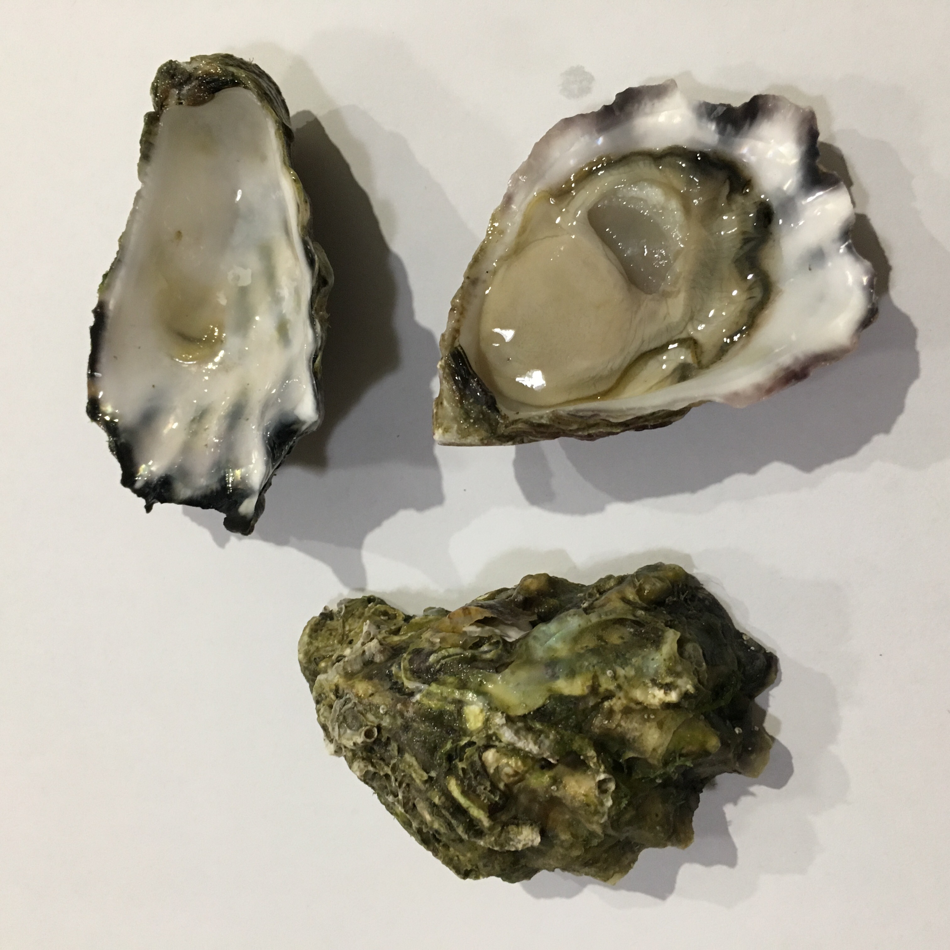
''Saccostrea glomerata'', is an oyster species belonging to the family Ostreidae.MolluscaBase eds. (2022). MolluscaBase. Saccostrea Dollfus & Dautzenberg, 1920. Accessed through: World Register of Marine Species at: https://www.marinespecies.org/aphia.php?p=taxdetails&id=138300 on 2022-04-27 It is endemic to Australia and New Zealand. In Australia, it is known as the Sydney rock oyster and is commercially farmed. In New Zealand, where the species is not farmed, it is known as the New Zealand rock oyster or Auckland oyster. The species is closely related to ''Saccostrea cucullata'', the hooded oyster, which is common on Indo-Pacific rocky shores. Sydney rock oysters are capable of tolerating a wide range of salinities (halotolerant). They are usually found in the intertidal zone to below the low-water mark. Taxonomy The Sydney rock oyster and New Zealand rock oyster have previously been classified as two separate species: ''Saccostrea commercialis'' and ''S. glomerata'', resp ... [...More Info...] [...Related Items...] OR: [Wikipedia] [Google] [Baidu] |
Victoria (Australia)
Victoria is a state in southeastern Australia. It is the second-smallest state with a land area of , the second most populated state (after New South Wales) with a population of over 6.5 million, and the most densely populated state in Australia (28 per km2). Victoria is bordered by New South Wales to the north and South Australia to the west, and is bounded by the Bass Strait to the south (with the exception of a small land border with Tasmania located along Boundary Islet), the Great Australian Bight portion of the Southern Ocean to the southwest, and the Tasman Sea (a marginal sea of the South Pacific Ocean) to the southeast. The state encompasses a range of climates and geographical features from its temperate coastal and central regions to the Victorian Alps in the northeast and the semi-arid north-west. The majority of the Victorian population is concentrated in the central-south area surrounding Port Phillip Bay, and in particular within the metropolit ... [...More Info...] [...Related Items...] OR: [Wikipedia] [Google] [Baidu] |


.jpg)


