|
William Gilbert Puckey
William Gilbert Puckey (5 May 1805 – 27 March 1878), born in Penryn, England, was a missionary in New Zealand. He accompanied his parents to New Zealand at the age of 14. He became widely regarded as one of the best interpreters of Māori in the fledgling mission. He was able to form relationships of trust with many influential Māori from a young age, and in particular, with Nōpera Panakareao, of Te Rarawa iwi at Kaitaia. The night before the signing of the Treaty of Waitangi at Kaitaia, Panakareao called for Puckey and spent a long time discussing and questioning the meaning, translation, and significance of the term " kawanatanga" which Henry Williams had used in the Treaty. In Panakareo's speech to assembled chiefs, (translated by Puckey and recorded by Richard Taylor at the time), he endorsed the Treaty. He said he understood the words of the Treaty to mean that "the shadow of the land was passing to the Queen, while the substance remained with Māori", a view he perce ... [...More Info...] [...Related Items...] OR: [Wikipedia] [Google] [Baidu] |
Penryn, Cornwall
Penryn (; kw, Pennrynn, meaning 'promontory') is a civil parish and town in west Cornwall, England, United Kingdom. It is on the Penryn River about northwest of Falmouth. The population was 7,166 in the 2001 census and had been reduced to 6,812 in the 2011 census, a drop of more than 300 people across the ten-year time gap. There are two electoral wards covering Penryn: 'Penryn East and Mylor' and 'Penryn West'. The total population of both wards in the 2011 census was 9,790. Though now the town is overshadowed by the larger nearby town of Falmouth, Penryn was once an important harbour in its own right, lading granite and tin to be shipped to other parts of the country and world during the medieval period. History Early history The ancient town first appears in the Domesday Book under the name of "Trelivel", and was since founded and named Penryn in 1216 by the Bishop of Exeter. The borough was enfranchised and its Charter of Incorporation was made in 1236. The content ... [...More Info...] [...Related Items...] OR: [Wikipedia] [Google] [Baidu] |
London Missionary Society
The London Missionary Society was an interdenominational evangelical missionary society formed in England in 1795 at the instigation of Welsh Congregationalist minister Edward Williams. It was largely Reformed in outlook, with Congregational missions in Oceania, Africa, and the Americas, although there were also Presbyterians (notable for their work in China), Methodists, Baptists, and various other Protestants involved. It now forms part of the Council for World Mission. Origins In 1793, Edward Williams, then minister at Carr's Lane, Birmingham, wrote a letter to the churches of the Midlands, expressing the need for interdenominational world evangelization and foreign missions.Wadsworth KW, ''Yorkshire United Independent College -Two Hundred Years of Training for Christian Ministry by the Congregational Churches of Yorkshire'' Independent Press, London, 1954 It was effective and Williams began to play an active part in the plans for a missionary society. He left Birmingham ... [...More Info...] [...Related Items...] OR: [Wikipedia] [Google] [Baidu] |
Cape Reinga
, type =Cape , photo = Cape Reinga, Northland, New Zealand, October 2007.jpg , photo_width = 270px , photo_alt = , photo_caption = , map = New Zealand , map_width = 270px , map_caption = , map_alt = , relief = , label = Cape Reinga , label_position = , mark = , marker_size = , location = Northland, New Zealand , grid_ref = , grid_ref_UK = , grid_ref_Ireland = , coordinates = , coordinates_ref = , range = , part_of = , water_bodies = Tasman Sea , elevation_ft = , elevation_ref = , surface_elevation_ft = , surface_elevation_ref = , highest_point = , highest_elevation = , highest_coords = , length = , width = , area = , depth = , drop = , formed_by = , g ... [...More Info...] [...Related Items...] OR: [Wikipedia] [Google] [Baidu] |
Ninety Mile Beach, New Zealand
Te-Oneroa-a-Tōhē / Ninety Mile Beach Deed Of Settlement, Ngati Kuri and the Crown. Retrieved 10 February 2014 is on the western coast of the Far North District, far north of the of . The beach is actually long. Its southern end is close to the headland of Tauroa Point, to the west of Ahipara Bay, near |
Adam Matthew Digital
Adam Matthew Digital is an academic publisher based in the United Kingdom and the United States. It has been an independent subsidiary of Sage Publications since 2012. The company specializes in online primary source databases and curated collections for the humanities and social sciences. Its corporate offices are in Marlborough, Wiltshire. History Adam Matthew Publications was founded in 1990 by David Tyler and William Pidduck. The company focused on publishing microfilm collections with a back list of over 600 titles until publishing their first ‘digital’ collections in the late 1990s on CD-ROM, and releasing its first truly online resources in the early 2000s. By the mid-2000s, the company directors – now including Khal Rudin - founded Adam Matthew Digital to focus solely on the development and production of digital collections, and began trading as a separate entity from 1 January 2007. On 5 October 2012, the company was acquired by SAGE Publications. Collections ... [...More Info...] [...Related Items...] OR: [Wikipedia] [Google] [Baidu] |
Paihia
Paihia is the main tourist town in the Bay of Islands in the Northland Region of the North Island of New Zealand. It is 60 kilometres north of Whangārei, located close to the historic towns of Russell and Kerikeri. Missionary Henry Williams named the mission station ''Marsden's Vale''. Paihia eventually became the accepted name of the settlement. Nearby to the north is the historic settlement of Waitangi, and the residential and commercial area of Haruru Falls is to the west. The port and township of Opua, and the small settlement of Te Haumi, lie to the south. History and culture Origin of the Name The origin of the name "Paihia" is unclear. A popular attribution, most likely apocryphal, is that when Reverend Henry Williams first arrived in the Bay of Islands searching for a location for his mission station, he told his Māori guide, "Pai here," meaning "Good here," as his Māori vocabulary was limited. European settlement Henry Williams and his wife Marianne settl ... [...More Info...] [...Related Items...] OR: [Wikipedia] [Google] [Baidu] |
Kerikeri
Kerikeri () is the largest town in Northland, New Zealand. It is a tourist destination north of Auckland and north of the northern region's largest city, Whangarei. It is sometimes called the Cradle of the Nation, as it was the site of the first permanent mission station in the country, and it has some of the most historic buildings in the country. A rapidly expanding centre of subtropical and allied horticulture, Kerikeri is in the Far North District of the North Island and lies at the western extremity of the Kerikeri Inlet, a northwestern arm of the Bay of Islands, where fresh water of the Kerikeri River enters the Pacific Ocean. The village was established by New Zealand's pioneering missionaries, who called it Gloucester Town, but the name did not endure. The Māori word ''Kerikeri'' was interpreted by said missionaries as Keddi Keddi or Kiddeekiddee, before the romanisation methods they used were revised to what is used today. In 1814, Samuel Marsden acquired lan ... [...More Info...] [...Related Items...] OR: [Wikipedia] [Google] [Baidu] |
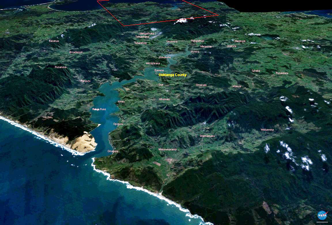
Hokianga Harbour
The Hokianga is an area surrounding the Hokianga Harbour, also known as the Hokianga River, a long estuarine drowned valley on the west coast in the north of the North Island of New Zealand. The original name, still used by local Māori, is ''Te Kohanga o Te Tai Tokerau'' ("the nest of the northern people") or ''Te Puna o Te Ao Marama'' ("the wellspring of moonlight"). The full name of the harbour is Te Hokianga-nui-a-Kupe — "the place of Kupe's great return". Geography The Hokianga is in the Far North District, which is in the Northland Region. The area is northwest of Whangarei—and west of Kaikohe—by road. The estuary extends inland for from the Tasman Sea. It is navigable for small craft for much of its length, although there is a bar across the mouth. In its upper reaches the Rangiora Narrows separate the mouths of the Waihou and Mangamuka Rivers from the lower parts of the harbour. 12,000 years ago, the Hokianga was a river valley flanked by steep bu ... [...More Info...] [...Related Items...] OR: [Wikipedia] [Google] [Baidu] |
Mate (naval Officer)
A mate is a deck naval officer aboard a merchant vessel, such as the chief mate (first mate), second mate, or third mate. Between 1800 and 1890 "mate" was also the naval rank now known as sub-lieutenant—master. One of the mates is always the watch keeping officer, unless the master takes that responsibility. Each mate also has other duties, such as making the passage planning, overseeing loading and unloading and personnel management. The United States Navy had the rank of mate from the mid-1800s until the early 20th century. Mates in the US Navy were junior warrant officers, originally known as masters mates, who assisted a ship's sailing master. From 1912 to 1931, mate was a commissioned rank within the Royal Navy, for ratings who were selected for a commission through the Mate Scheme. Commissioned mates ranked with sub-lieutenants. In 1931, the scheme was renamed to the Upper Yardman Scheme, and those who selected under it were promoted to sub-lieutenant instead. Se ... [...More Info...] [...Related Items...] OR: [Wikipedia] [Google] [Baidu] |
Mission House
The Mission House at Kerikeri in New Zealand was completed in 1822 as part of the Kerikeri Mission Station by the Church Missionary Society, and is New Zealand's oldest surviving building. It is sometimes known as Kemp House. Samuel Marsden established the Anglican mission to New Zealand with lay preachers, who lived in the Bay of Islands under the protection of Hongi Hika, the chief of the local tribe, the Ngāpuhi. In November 1819, Marsden purchased 13,000 acres (53 km2) from the Ngapuhi. Marsden instructed the Reverend John Butler to erect buildings for the mission station under the shelter of the Ngapuhi Pa or fortress of Kororipo at Kerikeri, (Marsden, himself, Thomas Kendall and Hongi Hika left for Britain). Using Māori and skilled European labour, Butler had completed the centre piece Mission House by 1822, (despite being interrupted by the return of Kendall and Hongi Hika with a thousand muskets, and Kororipo being used as a base for the subsequent Ngapuhi mili ... [...More Info...] [...Related Items...] OR: [Wikipedia] [Google] [Baidu] |
Samuel Marsden
Samuel Marsden (25 June 1765 – 12 May 1838) was an English-born priest of the Church of England in Australia and a prominent member of the Church Missionary Society, believed to have introduced Christianity to New Zealand. Marsden was a prominent figure in early New South Wales and Australian history, partly through his ecclesiastical offices as the colony's senior Church of England cleric and as a pioneer of the Australian wool industry, but also for his employment of convicts for farming and his actions as a magistrate at Parramatta, both of which attracted contemporary criticism. Early life Born in Farsley, near Pudsey, Yorkshire in England as the son of a Wesleyan blacksmith turned farmer, Marsden attended the village school and spent some years assisting his father on the farm. In his early twenties his reputation as a lay preacher drew the attention of the evangelical Elland Society, which sought to train poor men for the ministry of the Church of England. With a scho ... [...More Info...] [...Related Items...] OR: [Wikipedia] [Google] [Baidu] |


.jpg)