|
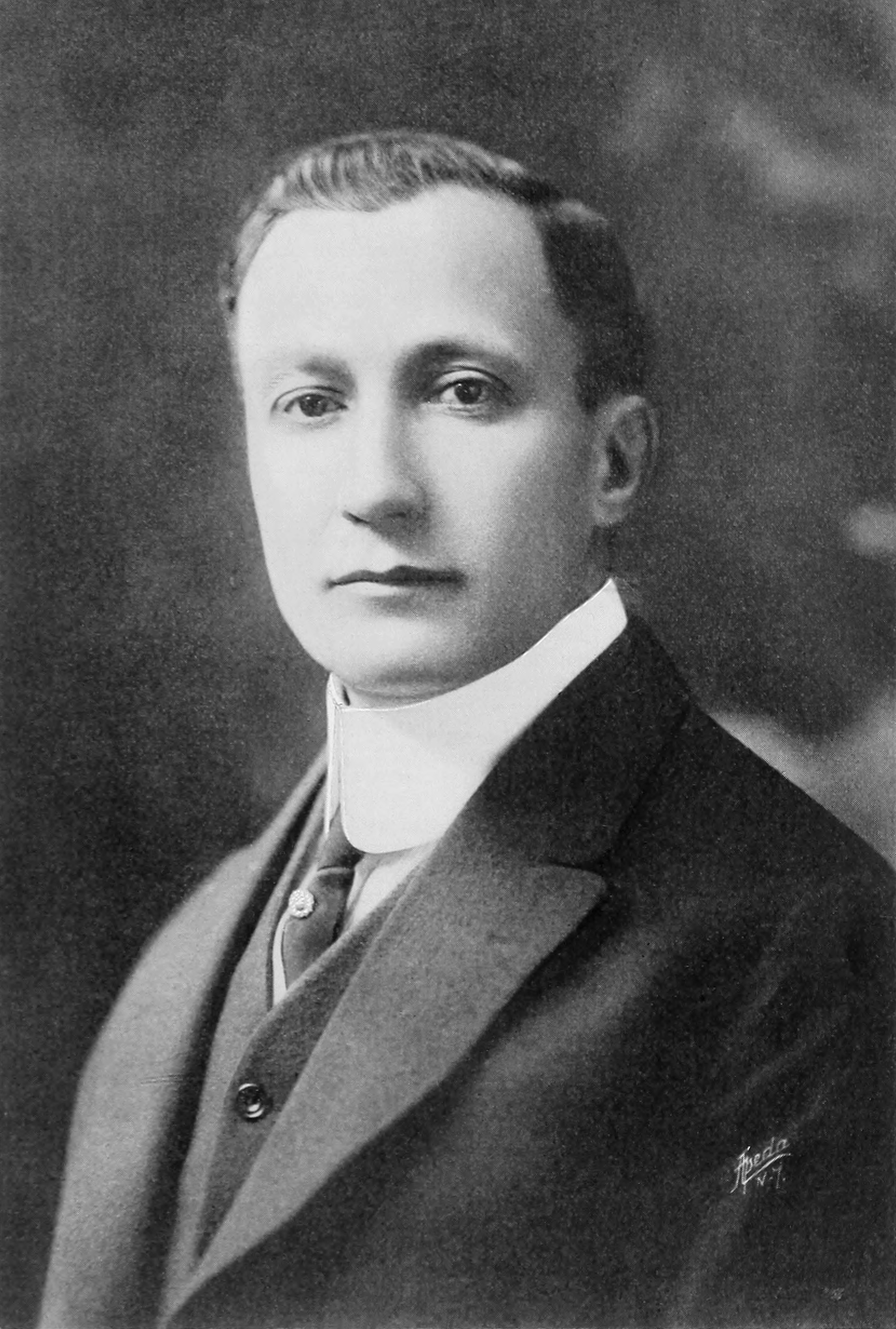
Wilhelm Eduard Brodtbeck
Wilhelm Eduard Brodtbeck (25 September 1873 in Liestal - 12 April 1957, in Liestal) was a famous Swiss architect from Liestal canton Basel-Country. Biography Early life Wilhelm Eduard, son of Wilhelm senior (architect and cement factory owner) and Susanne Karoline Spinnler, grew up in Liestal. Primarily Wilhelm Brodtbeck visited schools in Liestal and then at a later age in Basel. He then studied architecture, concluding at the University of Stuttgart und at the University of Karlsruhe. Later he made various studium journeys in Germany, Holland, Austria, Italy and France, hereafter Brodtbeck worked in Lausanne. He married Susanna Elisabeth Buess from Wenslingen, Basel-Country, in 1904. Career Wilhelm Brodtbeck founded his own architect's office in 1901 in Liestal. As young architect he accomplished a large variety of residential houses. Later he expanded his horizon and realized schools complexes and industrial buildings. As from 1921, together with his partner Fritz Bohny, ... [...More Info...] [...Related Items...] OR: [Wikipedia] [Google] [Baidu] |
Liestal
Liestal (, Standard ), formerly spelled Liesthal, is the capital of Liestal District and the canton of Basel-Landschaft in Switzerland, south of Basel. Liestal is an industrial town with a cobbled-street Old Town. The official language of Liestal is (the Swiss variety of Standard) German, but the main spoken language is the local variant of the Alemannic Swiss German dialect. History The name ''Liestal'' was first mentioned in 1225, and the settlement dates at least from Roman times. The development of the town is due to its strategic location on the road between the first bridge over the Rhine at Basel and the St. Gotthard Pass. Citizens of Liestal participated in the Burgundian Wars in 1476 and 1477 against Charles the Bold. In 1501, the mayor swore allegiance to the Swiss Confederation, and this caused repeated conflict with neighboring Rheinfelden, which belonged to the Habsburgs. In the 17th century, Liestal rebelled against Basel as part of the Farmers' Rebellion an ... [...More Info...] [...Related Items...] OR: [Wikipedia] [Google] [Baidu] |
Muttenz
Muttenz is a municipality with a population of approximately 17,000 in the canton of Basel-Country in Switzerland. It is located in the district of Arlesheim and next to the city of Basel. History Under the Roman Empire a hamlet called Montetum existed, which the Alamanni invaders referred to as Mittenza since the 3rd century CE. At the beginning of the 9th century CE the settlement came into the possession of the bishopric of Strasbourg. In the following centuries various noble families were invested with the fief. Muttenz is first mentioned around 1225-26 as ''Muttence''. In 1277 it was mentioned as ''Muttenza''. In 1306 the village became the property of the Münch of Münchenstein, who fortified the village church of St. Arbogast with a rampart at the beginning of the 15th century, after their fortresses on the nearby Wartenberg were partially destroyed in the devastating Basle earthquake of 1356. Having fallen on hard times the Münch sold the village and the Wartenber ... [...More Info...] [...Related Items...] OR: [Wikipedia] [Google] [Baidu] |
1873 Births
Events January–March * January 1 ** Japan adopts the Gregorian calendar. ** The California Penal Code goes into effect. * January 17 – American Indian Wars: Modoc War: First Battle of the Stronghold – Modoc Indians defeat the United States Army. * February 11 – The Spanish Cortes deposes King Amadeus I, and proclaims the First Spanish Republic. * February 12 ** Emilio Castelar, the former foreign minister, becomes prime minister of the new Spanish Republic. ** The Coinage Act of 1873 in the United States is signed into law by President Ulysses S. Grant; coming into effect on April 1, it ends bimetallism in the U.S., and places the country on the gold standard. * February 20 ** The University of California opens its first medical school in San Francisco. ** British naval officer John Moresby discovers the site of Port Moresby, and claims the land for Britain. * March 3 – Censorship: The United States Congress enacts the Comstock Law, making it ... [...More Info...] [...Related Items...] OR: [Wikipedia] [Google] [Baidu] |
Swiss Architects
Swiss may refer to: * the adjectival form of Switzerland *Swiss people Places *Swiss, Missouri * Swiss, North Carolina *Swiss, West Virginia * Swiss, Wisconsin Other uses *Swiss-system tournament, in various games and sports *Swiss International Air Lines **Swiss Global Air Lines, a subsidiary *Swissair, former national air line of Switzerland *.swiss alternative TLD for Switzerland See also *Swiss made, label for Swiss products *Swiss cheese (other) *Switzerland (other) *Languages of Switzerland, none of which are called "Swiss" *International Typographic Style, also known as Swiss Style, in graphic design *Schweizer (other), meaning Swiss in German *Schweitzer, a family name meaning Swiss in German *Swisse Swisse is a vitamin, supplement, and skincare brand. Founded in Australia in 1969 and globally headquartered in Melbourne, and was sold to Health & Happiness, a Chinese company based in Hong Kong previously known as Biostime International, in ... [...More Info...] [...Related Items...] OR: [Wikipedia] [Google] [Baidu] |
Hans Benno Bernoulli
Hans Benno Bernoulli (17 February 1876 – 12 September 1959) was a Swiss architect and city planner. Family Bernoulli was born in Basel, the son of Theodor Bernoulli, an office clerk. He was descended from the Bernoulli family of mathematicians. The suffragette and feminist Elisabeth Bernoulli (1873–1935) was his sister. In 1904 he married Anna Ziegler in Berlin. Career He studied architecture at the Technische Universität München and in 1902 started a partnership in Berlin. In 1912 he was appointed "chief architect" for the Basler building industry. His most important housing development projects were: * 1914–1929: Bernoullihäuser in Zürich, (Hardturmstrasse). The Bernoulli houses are named after the architect. These houses are a garden city project, from the 1920s and were meant to be sold without profit to the workers. You will find the Bernoulli houses on Zürich tram lines no. 8 and 17 between the stations Bernoulli and Hardturm. * 1919: Bernoullihäus ... [...More Info...] [...Related Items...] OR: [Wikipedia] [Google] [Baidu] |
Münchenstein
Münchenstein (Swiss German: ''Minggestai'') is a municipality in the district of Arlesheim in the canton of Basel-Landschaft in Switzerland. Historical records Münchenstein is first mentioned in 1196 as ''Kekingen''. In 1270, it was mentioned as ''Geckingen'' and in 1279 as ''Munchenstein''. * 1259: The hamlet and the mill, between "Neue Welt" and St. Jakob, are mentioned in a deed as being owned by the Basel Dompropstei (Provost's Church). * 1270: The village is named in the Bishop of Basel diocese certificate as Geckingen. * 1295: The mention of the name in the current form "Munchenstein", which means the "rock of the castle of the Münchs". The first part of the name refers to the builders of the castle, and the second part means stone and refers to the foundations of the castle. * 1324: The Münchs were not able keep the village and castle for long as their own Property, they had to hand over ownership to the Graf von Pfirt, who then lent it to the Münchs in fief. Fol ... [...More Info...] [...Related Items...] OR: [Wikipedia] [Google] [Baidu] |
Neue Welt
The Neue Welt is a sub-district of Münchenstein, in the canton of Basel-Country in Switzerland. Geographical location The geographical area called the ''Neue Welt'' (new world) evolved in the 17th century as the industry started establishing itself around the upper end of the "St. Alban-Teich". This is a canal, artificially constructed by the Basler Kloster St. Alban during the 12th century, so as to bring water and water power to the industry in Basel. Later, during the years 1624–25, the canal was prolonged through Brüglingen towards the Birs waterfall in Münchenstein and from here the water is diverged. The ''Neue Welt'' is the northernmost district of Münchenstein. ''Neue Welt'' lies along the western bank of the river Birs. To its east it borders on the municipality of Muttenz and to the west it borders on ''Dreispitz'', a business and economic service neighbourhood that lies half in Basel and in Münchenstein. To the north ''Neue Welt'' borders on St. Jakob an de ... [...More Info...] [...Related Items...] OR: [Wikipedia] [Google] [Baidu] |
Wasserhaus (Münchenstein)
The residential estate Wasserhaus is in the sub-district ''Neue Welt'', Münchenstein, Basel-Country near Basel (Switzerland) Birs waterfall and power station The German word "Siedlung" means settlement (housing development or residential area). Geographical location The environmental area called the ''Neue Welt'' (new world) evolved in the 17th century as the industry started to establish itself around the upper end of the "St. Alban-Teich". This is an artificially constructed canal built during the 12th century to bring water (water power) to the industry in Basel. Later, during 1624–25, the canal was prolonged through Brüglingen towards the Birs waterfall in Münchenstein. From here the water is diverged to the canal. Here there is a small power station that has been built onto the waterfall. The residential estate Wasserhaus lies on the left bank of the river Birs, between the industrial area of the Neue Welt and the waterfall. History Up until the end of the First Wor ... [...More Info...] [...Related Items...] OR: [Wikipedia] [Google] [Baidu] |
Lausen
Lausen is a municipality in the district of Liestal in the canton of Basel-Country in Switzerland. History Lausen is first mentioned in 1275 as ''in villa et banno Langenso''. In 1305 it became the property of the Bishop of Basel, passing in 1400 to the city of Basel. Geography Lausen has an area, , of . Of this area, or 23.6% is used for agricultural purposes, while or 50.5% is forested. Of the rest of the land, or 25.0% is settled (buildings or roads), or 0.5% is either rivers or lakes and or 0.4% is unproductive land.Swiss Federal Statistical Office-Land Use Statistics 2009 data accessed 25 March 2010 Of the built up area, industrial buildings made up 3.8% of the total area while housing and buildings made up 12.9% and transportation infra ... [...More Info...] [...Related Items...] OR: [Wikipedia] [Google] [Baidu] |
Cantons Of Switzerland
The 26 cantons of Switzerland (german: Kanton; french: canton ; it, cantone; Sursilvan and Surmiran: ; Vallader and Puter: ; Sutsilvan: ; Rumantsch Grischun: ) are the member states of the Swiss Confederation. The nucleus of the Swiss Confederacy in the form of the first three confederate allies used to be referred to as the . Two important periods in the development of the Old Swiss Confederacy are summarized by the terms ('Eight Cantons'; from 1353–1481) and ('Thirteen Cantons', from 1513–1798).rendered "the 'confederacy of eight'" and "the 'Thirteen-Canton Confederation'", respectively, in: Each canton of the Old Swiss Confederacy, formerly also ('lieu/locality', from before 1450), or ('estate', from ), was a fully sovereign state with its own border controls, army, and currency from at least the Treaty of Westphalia (1648) until the establishment of the Swiss federal state in 1848, with a brief period of centralised government during the Helvetic Republic ( ... [...More Info...] [...Related Items...] OR: [Wikipedia] [Google] [Baidu] |
Binningen, Switzerland
Binningen (Swiss German: ''Binnige'') is a municipality in the district of Arlesheim in the canton of Canton of Basel-Landschaft in Switzerland. It is nestled in a valley, on a plateau, and on two hills overlooking the city of Basel. History Binningen is first mentioned in 1004 as ''Binningen''. Various versions of the name Binningen appear in records dating from between the eleventh and fourteenth centuries, such as "Binnengin" and "Biningin". Geography Binningen has an area, , of . Of this area, or 21.0% is used for agricultural purposes, while or 7.0% is forested. Of the rest of the land, or 72.0% is settled (buildings or roads) and or 0.5% is unproductive land.Swiss Federal Statistical Office-Land Use Statistics 2009 data accessed 25 March 2010 [...More Info...] [...Related Items...] OR: [Wikipedia] [Google] [Baidu] |


