|
Whitetop Laurel
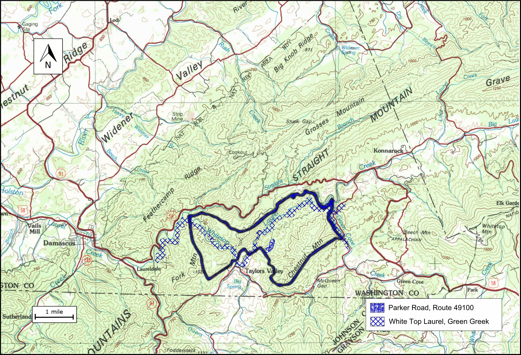
Whitetop Laurel is a wildland in the George Washington and Jefferson National Forests of western Virginia that has been recognized by the Wilderness Society as a special place worthy of protection from logging and road construction. The Wilderness Society has designated the area as a "Mountain Treasure".Virginia's Mountain Treasures, report issued by The Wilderness Society, May, 1999 The Appalachian Trail and Virginia Creeper Trail follow Whitetop Laurel Creek through a gorge with rich cove hardwood forests and thick rhododendrons. The area is one of the most popular recreational hubs in the Mount Rogers National Recreation Area. Whitetop Laurel Creek is a popular wild trout stream with wildlife viewing platforms and streamside access by wheelchair. The area is part of the ''Mount Rogers Cluster''. Location and access The area is located in the Appalachian Mountains of Southwestern Virginia about 4.2 miles east of Damascus, Virginia between Va 859 (Grassy Ridge Road) on the ... [...More Info...] [...Related Items...] OR: [Wikipedia] [Google] [Baidu] |
George Washington And Jefferson National Forests
The George Washington and Jefferson National Forests is an administrative entity combining two U.S. National Forests into one of the largest areas of public land in the Eastern United States. The forests cover of land in the Appalachian Mountains of Virginia, West Virginia, and Kentucky. Approximately of the forest are remote and undeveloped and have been designated as wilderness areas, which prohibits future development. History George Washington National Forest was established on May 16, 1918, as the Shenandoah National Forest. The forest was renamed after the first President on June 28, 1932. Natural Bridge National Forest was added on July 22, 1933. Jefferson National Forest was formed on April 21, 1936, by combining portions of the Unaka and George Washington National Forests with other land. In 1995, the George Washington and Jefferson National Forests were administratively combined. The border between the two forests roughly follows the James River. The combine ... [...More Info...] [...Related Items...] OR: [Wikipedia] [Google] [Baidu] |
United States Geological Survey
The United States Geological Survey (USGS), formerly simply known as the Geological Survey, is a scientific agency of the United States government. The scientists of the USGS study the landscape of the United States, its natural resources, and the natural hazards that threaten it. The organization's work spans the disciplines of biology, geography, geology, and hydrology. The USGS is a fact-finding research organization with no regulatory responsibility. The agency was founded on March 3, 1879. The USGS is a bureau of the United States Department of the Interior; it is that department's sole scientific agency. The USGS employs approximately 8,670 people and is headquartered in Reston, Virginia. The USGS also has major offices near Lakewood, Colorado, at the Denver Federal Center, and Menlo Park, California. The current motto of the USGS, in use since August 1997, is "science for a changing world". The agency's previous slogan, adopted on the occasion of its hundredt ... [...More Info...] [...Related Items...] OR: [Wikipedia] [Google] [Baidu] |
Inventoried Roadless Area
Inventoried Roadless Areas are a group of United States Forest Service lands that have been identified by government reviews as lands without existing roads that could be suitable for roadless area conservation as wilderness or other non-standard protections. The Inventoried Roadless areas include approximately of land in 40 states and Puerto Rico. Most of these lands are in the western portion of the lower 48 states and Alaska.Maps of inventoried roadless areasUS Forest Service Maps Idaho alone contains over of inventoried roadless areas. The inventoried roadless areas range from large areas with wilderness characteristics to small tracts of land that are immediately adjacent to wilderness areas, parks and other protected lands. Roadless Area Review and Evaluations (RARE) The first review of Forest Service roadless lands was started in 1967 after the creation of the Wilderness Act by Congress in 1964. This effort was called the “Roadless Area Review and Evaluation” or “ ... [...More Info...] [...Related Items...] OR: [Wikipedia] [Google] [Baidu] |
Rhythmite
A rhythmite consists of layers of sediment or sedimentary rock which are laid down with an obvious periodicity and regularity. They may be created by annual processes such as seasonally varying deposits reflecting variations in the runoff cycle, by shorter term processes such as tides, or by longer term processes such as periodic floods. Rhythmites serve a significant role in unraveling prehistoric events, providing insights into sea level change, glaciation change, and earth's orbital variations which serve to answer questions about climate change. Annually-laminated rhythmites Annually-laminated deposits (varves) are rhythmites with annual periodicity: annual layers of sediment or sedimentary rock are laid down through seasonal variations that result from precipitation, or from temperature, which influences precipitation rates and debris loads in runoff. Of the many rhythmites found in the geological record, varves are among the most important and illuminating to studies of pa ... [...More Info...] [...Related Items...] OR: [Wikipedia] [Google] [Baidu] |
Tillite
image:Geschiebemergel.JPG, Closeup of glacial till. Note that the larger grains (pebbles and gravel) in the till are completely surrounded by the matrix of finer material (silt and sand), and this characteristic, known as ''matrix support'', is diagnostic of till. image:Glacial till exposed in roadcut-750px.jpg, Glacial till with tufts of grass Till or glacial till is unsorted glacier, glacial sediment. Till is derived from the erosion and entrainment of material by the moving ice of a glacier. It is deposited some distance down-ice to form terminal, lateral, medial and ground moraines. Till is classified into primary deposits, laid down directly by glaciers, and secondary deposits, reworked by fluvial transport and other processes. Description Till is a form of ''glacial drift'', which is rock material transported by a glacier and deposited directly from the ice or from running water emerging from the ice. It is distinguished from other forms of drift in that it is deposi ... [...More Info...] [...Related Items...] OR: [Wikipedia] [Google] [Baidu] |
Diphylleia Cymosa
''Diphylleia cymosa'', the umbrella leaf, is an ornamental plant of the family Berberidaceae, which is native of United States The United States of America (U.S.A. or USA), commonly known as the United States (U.S. or US) or America, is a country primarily located in North America. It consists of 50 states, a federal district, five major unincorporated territorie .... It is endemic to the deciduous forests of the southeast United States and blooms in the late spring. References * External links {{Taxonbar, from=Q5279785 [...More Info...] [...Related Items...] OR: [Wikipedia] [Google] [Baidu] |
Hellbender
The hellbender (''Cryptobranchus alleganiensis''), also known as the hellbender salamander, is a species of aquatic giant salamander endemic to the eastern and central United States. It is the largest salamander in North America. A member of the family Cryptobranchidae, the hellbender is the only extant member of the genus ''Cryptobranchus''. Other closely related salamanders in the same family are in the genus ''Andrias'', which contains the Japanese and Chinese giant salamanders. The hellbender, which is much larger than all other salamanders in its geographic range, employs an unusual means of respiration (which involves cutaneous gas exchange through capillaries found in its dorsoventral skin folds), and fills a particular niche—both as a predator and prey—in its ecosystem, which either it or its ancestors have occupied for around 65 million years. The species is listed as Vulnerable on the IUCN Red List of Threatened Species. Etymology The origin of the name "hellben ... [...More Info...] [...Related Items...] OR: [Wikipedia] [Google] [Baidu] |
Fatlips Minnow
The fatlips minnow (''Phenacobius crassilabrum'') is a species of suckermouth minnow that was first described in the upper Tennessee River system. No fewer than 20 specimens were used for description, and the epithet ''crassilabrum'' (from the Latin ''crassus'' meaning thick or fat and labrum, or lip) was assigned to the species, separating it from ''Phenacobius catostomus,'' with which it had previously been identified. The first holotype specimen collected in 1947 was an adult female in length from the River. Geographic distribution The distribution of the fatlips minnow is restricted to North America, where it occurs in the upper Tennessee River drainage in western Virginia, western North Carolina, eastern Tennessee and northeastern Georgia. Its habitat is gravel and riffles in small to medium creeks. The fatlips minnow is believed to have arisen from a ''P. catostomus'' -like stock population that re-invaded the upper Tennessee River via reciprocal stream piracy. A genet ... [...More Info...] [...Related Items...] OR: [Wikipedia] [Google] [Baidu] |
Sharphead Darter
The sharphead darter (''Etheostoma acuticeps'') is a species of freshwater ray-finned fish, a darter from the subfamily Etheostomatinae, part of the family Percidae, which also contains the perches, ruffes and pikeperches. It is endemic to the eastern United States, where it is only known to occur in the Holston and Nolichucky River The Nolichucky River is a river that flows through Western North Carolina and East Tennessee, in the southeastern United States. Traversing the Pisgah National Forest and the Cherokee National Forest in the Blue Ridge Mountains, the river's wate ... systems. It inhabits small to medium-sized rivers, being found in rocky riffles in deep, fast-flowing waters. This species can reach a length of , though most only reach about . References Freshwater fish of the United States Etheostoma Fish described in 1959 Taxonomy articles created by Polbot {{Percidae-stub ... [...More Info...] [...Related Items...] OR: [Wikipedia] [Google] [Baidu] |
Greenfin Darter
The greenfin darter (''Etheostoma chlorobranchium'') is a species of freshwater ray-finned fish, a darter from the subfamily Etheostomatinae, part of the Family (biology), family Percidae, which also contains the perches, Gymnocephalus, ruffes and Sander (fish), pikeperches. It is endemism, endemic to the eastern United States. Geographic distribution The greenfin darter is primarily restricted to the fast-flowing, mountainous streams and rivers of the upper Tennessee River drainage area, in North Carolina, Georgia, and Tennessee. The species' range stretches from the upper Holston and Watauga Rivers, south through the French Broad and Little Tennessee Rivers, and ultimately ends at the Hiwassee River.Etnier, D. A., & Starnes, W. C. (1993). Fishes of Tennessee (pp. 478–479). University of Tennessee press. Ecology The greenfin darter is a benthic insectivore, feeding mainly on insect larvae in cold, high-elevation creeks and rivers. A study by Bryant'' et al.'' revealed the diet ... [...More Info...] [...Related Items...] OR: [Wikipedia] [Google] [Baidu] |


