|
West Surrey (UK Parliament Constituency)
West Surrey (formally the Western division of Surrey) was a United Kingdom constituencies, parliamentary constituency in the county of Surrey, which returned two Member of Parliament (United Kingdom), Members of Parliament (MPs) to the House of Commons of the United Kingdom, House of Commons of the Parliament of the United Kingdom, elected by the Plurality-at-large voting, bloc vote system. It was created under the Great Reform Act for the 1832 United Kingdom general election, 1832 general election, and abolished for the 1885 United Kingdom general election, 1885 general election. Boundaries 1832–1885: The Hundreds of Blackheath, Surrey (hundred), Blackheath, Copthorne (hundred), Copthorne, Effingham (half hundred), Effingham, Elmbridge (hundred), Elmbridge, Farnham (hundred), Farnham, Godalming (hundred), Godalming, Godley (hundred), Godley and Chertsey, Woking (hundred), Woking and Wotton (hundred), Wotton. The constituency was therefore the more extensive and more rural of ... [...More Info...] [...Related Items...] OR: [Wikipedia] [Google] [Baidu] |
Surrey Seats To 1885
Surrey () is a ceremonial and non-metropolitan county in South East England, bordering Greater London to the south west. Surrey has a large rural area, and several significant urban areas which form part of the Greater London Built-up Area. With a population of approximately 1.2 million people, Surrey is the 12th-most populous county in England. The most populated town in Surrey is Woking, followed by Guildford. The county is divided into eleven districts with borough status. Between 1893 and 2020, Surrey County Council was headquartered at County Hall, Kingston-upon-Thames (now part of Greater London) but is now based at Woodhatch Place, Reigate. In the 20th century several alterations were made to Surrey's borders, with territory ceded to Greater London upon its creation and some gained from the abolition of Middlesex. Surrey is bordered by Greater London to the north east, Kent to the east, Berkshire to the north west, West Sussex to the south, East Sussex to t ... [...More Info...] [...Related Items...] OR: [Wikipedia] [Google] [Baidu] |
Copthorne (hundred)
Copthorne was a hundred of Surrey, England, an area above the level of the parishes and manors, where the local wise, wealthy and powerful met periodically in Anglo-Saxon England for strategic purposes. After the Norman Conquest the lords of the manor took to annual hundred meetings and their status became eroded by royal-approved transactions of land, as meanwhile the manorial courts and moreover royal courts seized jurisdiction over the Hundred Courts. The name Copthorne may derive from a pollarded thorn tree at the place where the hundred met. The meeting point has been suggested to be marked by an earthwork and ancient hedge at the southern end of Woodcote Park, Epsom, close to Langley Vale. The earthwork is denoted as the ''Nutshambles'' on a map of Ashtead dating from 1638. Scope Copthorne comprised the manors of Ashtead, Burgh, Cuddington, Epsom, Ewell, Fetcham, Headley, Leatherhead, Mickleham, Pachevesham (within Leatherhead parish), Tadworth, Thorncroft and Wal ... [...More Info...] [...Related Items...] OR: [Wikipedia] [Google] [Baidu] |
Ewell
Ewell ( , ) is a suburban area with a village centre in the borough of Epsom and Ewell in Surrey, approximately south of central London and northeast of Epsom. In the 2011 Census, the settlement had a population of 34,872, a majority of which (73%) is in the ABC1 social class, except the Ruxley Ward that is C2DE. Ewell was founded as a spring line settlement, where the permeable chalk of the North Downs meets the impermeable London Clay, and the Hogsmill River (a tributary of the River Thames) still rises at a spring close to Bourne Hall in the village centre. Recorded in Domesday Book as ''Etwelle'', the settlement was granted a licence to hold a market in 1618. The opening of railway stations to the east and west of the centre, in 1847 and 1859 respectively, facilitated the creation of extensive residential areas, which are now contiguous with the Greater London suburbs. History The name ''Ewell'' derives from Old English ''æwell'', which means ''river source'' or sp ... [...More Info...] [...Related Items...] OR: [Wikipedia] [Google] [Baidu] |
Epsom
Epsom is the principal town of the Borough of Epsom and Ewell in Surrey, England, about south of central London. The town is first recorded as ''Ebesham'' in the 10th century and its name probably derives from that of a Saxon landowner. The earliest evidence of human activity is from the mid-Bronze Age, but the modern settlement probably grew up in the area surrounding St Martin's Church in the 6th or 7th centuries and the street pattern is thought to have become established in the Middle Ages. Today the High Street is dominated by the clock tower, which was erected in 1847–8. Like other nearby settlements, Epsom is located on the spring line where the permeable chalk of the North Downs meets the impermeable London Clay. Several tributaries of the Hogsmill River rise in the town and in the 17th and early 18th centuries, the spring on Epsom Common was believed to have healing qualities. The mineral waters were found to be rich in ''Epsom salts'', which were later ident ... [...More Info...] [...Related Items...] OR: [Wikipedia] [Google] [Baidu] |
Dorking
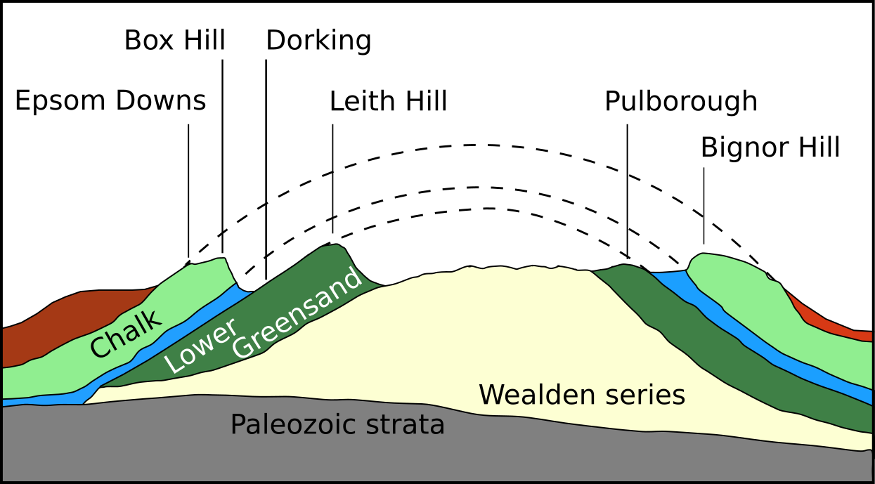
Dorking () is a market town in Surrey in South East England, about south of London. It is in Mole Valley District and the council headquarters are to the east of the centre. The High Street runs roughly east–west, parallel to the Pipp Brook and along the northern face of an outcrop of Lower Greensand. The town is surrounded on three sides by the Surrey Hills Area of Outstanding Natural Beauty and is close to Box Hill and Leith Hill. The earliest archaeological evidence of human activity is from the Mesolithic and Neolithic periods, and there are several Bronze Age bowl barrows in the local area. The town may have been the site of a staging post on Stane Street during Roman times, however the name 'Dorking' suggests an Anglo-Saxon origin for the modern settlement. A market is thought to have been held at least weekly since early medieval times and was highly regarded for the poultry traded there. The Dorking breed of domestic chicken is named after the tow ... [...More Info...] [...Related Items...] OR: [Wikipedia] [Google] [Baidu] |
Leatherhead
Leatherhead is a town in the Mole Valley District of Surrey, England, about south of Central London. The settlement grew up beside a ford on the River Mole, from which its name is thought to derive. During the late Anglo-Saxon period, Leatherhead was a royal vill and is first mentioned in the will of Alfred the Great in 880 AD. The first bridge across the Mole may have been constructed in around 1200 and this may have coincided with the expansion of the town and the enlargement of the parish church. For much of its history, Leatherhead was primarily an agricultural settlement, with a weekly market being held until the mid-Elizabethan era. The construction of turnpike roads in the mid-18th century and the arrival of the railways in the second half of the 19th century attracted newcomers and began to stimulate the local economy. Large-scale manufacturing industries arrived following the end of the First World War and companies with factories in the town included Ronson ... [...More Info...] [...Related Items...] OR: [Wikipedia] [Google] [Baidu] |
Guildford
Guildford () is a town in west Surrey, around southwest of central London. As of the 2011 census, the town has a population of about 77,000 and is the seat of the wider Borough of Guildford, which had around inhabitants in . The name "Guildford" is thought to derive from a crossing of the River Wey, a tributary of the River Thames that flows through the town centre. The earliest evidence of human activity in the area is from the Mesolithic and Guildford is mentioned in the will of Alfred the Great from . The exact location of the main Anglo-Saxon settlement is unclear and the current site of the modern town centre may not have been occupied until the early 11th century. Following the Norman Conquest, a motte-and-bailey castle was constructed, which was developed into a royal residence by Henry III. During the late Middle Ages, Guildford prospered as a result of the wool trade and the town was granted a charter of incorporation by Henry VII in 1488. The River Wey N ... [...More Info...] [...Related Items...] OR: [Wikipedia] [Google] [Baidu] |
Woking
Woking ( ) is a town and borough status in the United Kingdom, borough in northwest Surrey, England, around from central London. It appears in Domesday Book as ''Wochinges'' and its name probably derives from that of a Anglo-Saxon settlement of Britain, Saxon landowner. The earliest evidence of human activity is from the Paleolithic, but the low fertility of the sandy, local soils meant that the area was the least populated part of the county in 1086. Between the mid-17th and mid-19th centuries, new transport links were constructed, including the Wey and Godalming Navigations, Wey Navigation, Basingstoke Canal and South West Main Line, London to Southampton railway line. The modern town was established in the mid-1860s, as the London Necropolis Company began to sell surplus land surrounding Woking railway station, the railway station for home construction, development. Modern local government in Woking began with the creation of the Woking Local Board of Health, Local Board in ... [...More Info...] [...Related Items...] OR: [Wikipedia] [Google] [Baidu] |
Wotton (hundred)
The Hundred of Wotton, Wotton Hundred or Dorking Hundred was a hundred in Surrey, England. The hundred comprised a south-central portion of the county, clockwise the parishes of Abinger, Wotton, Dorking, Capel and Ockley. The area's owner initially had pecuniary rights (to incomes) over parts of parishes on the borders of the area and just beyond, from just north of Guildford to Sussex. The site of the Hundred Court is indicated in the later medieval records as Dorking, hence its latter alternative name. What vestiges of rights to minor rents and other such rights in the hundred still remained in the 17th century were granted to Sir Edward Zouche in 1620 by James I, and later passed to the Earls of Onslow, heirs to the estates of the Earls of Surrey. Subsequent large village-size settlements within this area include the three Holmwoods collectively and Holmbury St Mary. The majority of it today, which is farmland or woodland, is Metropolitan Green Belt The Metro ... [...More Info...] [...Related Items...] OR: [Wikipedia] [Google] [Baidu] |
Woking (hundred)
:''See Woking for the town or Borough of Woking for the district.'' Woking was a Hundred (county subdivision), hundred in what is now Surrey, England. It includes the town of Woking and the Borough of Woking. The Hundred comprised the parishes of: Ash, Surrey, Ash, East Clandon, West Clandon, East Horsley, West Horsley, Merrow, Surrey, Merrow, Ockham, Surrey, Ockham, Pirbright, Send, Surrey, Send and Ripley, Surrey, Ripley, Guildford, Stoke Juxta Guildford, Wanborough, Surrey, Wanborough, Windlesham, Wisley, Woking and Worplesdon. Minor clerical errors and convenience groupings of other parishes have occurred in some medieval centrally held records at Lambeth and Westminster Palaces for example. In the time of Edward the Confessor, the Hundred was worth £88; by the Domesday Book of 1086 it was worth £125. By 1696, it was worth £297 for taxation purposes ('taxable value') but being a Hundred had no single owner as such; as the rights of the hundreds became divided and lessened ... [...More Info...] [...Related Items...] OR: [Wikipedia] [Google] [Baidu] |
Godley (hundred)
Godley was a hundred in what is now Surrey, England. Egham, Thorpe, Chertsey and Chobham are all mentioned in the Chertsey Abbey charter of 673 AD due to a donation by Frithuwold. Chobham manor needed to be large to have a reasonable economic importance as it covered very poor quality heathland. Most of the population of the hundred would have settled on the more fertile alluvial soil bordering the River Thames. Godley appears in Domesday Book of 1086 as ''Godelie''. Godley was a hundred (these are not marked on the Surrey map, which shows only Domesday manors) an administrative area, where local leaders met about once a month. It included the manors of Chobham, Egham, Thorpe, Chertsey, Pyrford and Byfleet. Pyrford is within the Godley hundred but unusually lies within the Woking parish. The hundred was probably bounded to the west by the River Blackwater and to the north by the River Thames. To the north was the Land of ''Sunningas''; to the south Woking (hundred) and the ... [...More Info...] [...Related Items...] OR: [Wikipedia] [Google] [Baidu] |
Godalming (hundred)
Godalming was an ancient hundred in the south west of the county of Surrey, England. It corresponds to the central third of the current borough of Waverley and some parts of the current borough of Guildford. Broadly speaking it extended from Guildown in the north to the border with Sussex in the south. Local people maintain the notion of the hundred, sometimes colloquially referred to as ''Godhelmia'', mainly because of the predominance of north/south routes of communication through the area that have existed since ancient times. As recently as 1995 there were proposals (from Surrey County Council) to recreate a local government unit based on the old hundred borders. History The Hundred of Godalming was formed sometime after 825 when Wessex annexed the "south eastern provinces" of Surrey, Sussex, Kent and Essex. Etymology Godalming takes its name from the Old English ''Godhelm Ingas'' meaning "the clan of Godhelm". It is supposed that Godhelm was a Saxon chieftain who first ... [...More Info...] [...Related Items...] OR: [Wikipedia] [Google] [Baidu] |

.jpg)


.jpg)


