|
West Oakland
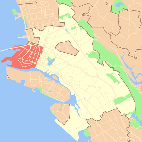
West Oakland is a neighborhood situated in the northwestern corner of Oakland, California, United States, situated west of Downtown Oakland, south of Emeryville, and north of Alameda. The neighborhood is located along the waterfront at the Port of Oakland and at the eastern end of the San Francisco–Oakland Bay Bridge. It lies at an elevation of 13 feet (4 m). History The land which comprises part of West Oakland was granted to Luis Maria Peralta in 1820. In the 1850s, a group of men who had been leasing the land from his son Vicente, Horace Carpentier, Edson Adams, and Andrew J. Moon, began illegally selling small farm plots west of what is now Market Street.Bagwell, Beth. Oakland, The Story of a City, 1996, Oakland Heritage Alliance, 2nd ed. One of the squatters, Horace Carpentier became Oakland's first mayor in 1854. The population grew after 1863, when the San Francisco-Oakland railroad connected central Oakland to the San Francisco bay ferries. In 1869, West Oakland ... [...More Info...] [...Related Items...] OR: [Wikipedia] [Google] [Baidu] |
Oakland West Oakland Locator Map
Oakland is the largest city and the county seat of Alameda County, California, United States. A major West Coast port, Oakland is the largest city in the East Bay region of the San Francisco Bay Area, the third largest city overall in the Bay Area and the eighth most populated city in California. With a population of 440,646 in 2020, it serves as the Bay Area's trade center and economic engine: the Port of Oakland is the busiest port in Northern California, and the fifth busiest in the United States of America. An act to incorporate the city was passed on May 4, 1852, and incorporation was later approved on March 25, 1854. Oakland is a charter city. Oakland's territory covers what was once a mosaic of California coastal terrace prairie, oak woodland, and north coastal scrub. In the late 18th century, it became part of a large ''rancho'' grant in the colony of New Spain. Its land served as a resource when its hillside oak and redwood timber were logged to build San Francisco. ... [...More Info...] [...Related Items...] OR: [Wikipedia] [Google] [Baidu] |
Pullman Palace Car Company
The Pullman Company, founded by George Pullman, was a manufacturer of railroad cars in the mid-to-late 19th century through the first half of the 20th century, during the boom of railroads in the United States. Through rapid late-19th century development of mass production and takeover of rivals, the company developed a virtual monopoly on production and ownership of sleeper cars. During a severe economic downturn, the 1894 Pullman Strike by company workers proved a transforming moment in American labor history. At the company's peak in the early 20th century, its cars accommodated 26 million people a year, and it in effect operated "the largest hotel in the world". Its production workers initially lived in a planned worker community (or "company town") named Pullman, Chicago. Pullman developed the sleeping car, which carried his name into the 1980s. Pullman did not just manufacture the cars, it also operated them on most of the railroads in the United States, paying rail ... [...More Info...] [...Related Items...] OR: [Wikipedia] [Google] [Baidu] |
Cypress Freeway
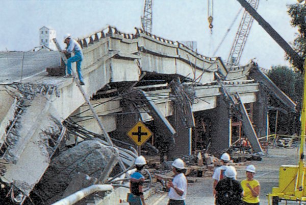
The Cypress Street Viaduct, often referred to as the Cypress Structure or the Cypress Freeway, was a 1.6-mile-long (2.5 km), raised two-deck, multi-lane (four lanes per tier) freeway constructed of reinforced concrete that was originally part of the Nimitz Freeway ( State Route 17, and later, Interstate 880) in Oakland, California. It replaced an earlier single-deck viaduct constructed in the 1930s as one of the approaches to the San Francisco–Oakland Bay Bridge. It was located along Cypress Street between 7th Street and Interstate 80 in the West Oakland neighborhood. It officially opened to traffic on June 11, 1957, and was in use until October 17, 1989. At approximately 5:04 p.m. that day, a magnitude 6.9 earthquake struck the Bay Area, resulting in a large portion of the freeway's upper deck collapsing onto the lower deck. The collapse killed 42 people and resulted in the subsequent demolition of the structure. The Cypress Freeway Memorial Park is located in Oaklan ... [...More Info...] [...Related Items...] OR: [Wikipedia] [Google] [Baidu] |
Oakland Army Base
The Oakland Army Base, also known as the Oakland Army Terminal, is a decommissioned United States Army base in the San Francisco Bay Area of California. The base was located at the Port of Oakland on Maritime Street just south of the eastern entrance to the San Francisco–Oakland Bay Bridge. Construction of the base commenced in 1941 as a part of the expanding San Francisco Port of Embarkation which was headquartered at Fort Mason on the San Francisco waterfront. Initially named the ''Oakland Sub-Port of the San Francisco Port of Embarkation'', the base was renamed the Oakland Army Base in 1944. The installation moved in excess of 8.5 million tons of cargo during World War II, and 7.2 million tons of cargo passed through the terminal during the Korean War. In 1946, the Oakland Army Base expanded to incorporate the administrative and cantonment area of the Port formerly known as Camp John T. Knight in honor of World War I Brigadier General John Thornton Knight. In 1955 the ''San F ... [...More Info...] [...Related Items...] OR: [Wikipedia] [Google] [Baidu] |
The Depression
The Great Depression (19291939) was an economic shock that impacted most countries across the world. It was a period of economic depression that became evident after a major fall in stock prices in the United States. The economic contagion began around September and led to the Wall Street stock market crash of October 24 (Black Thursday). It was the longest, deepest, and most widespread depression of the 20th century. Between 1929 and 1932, worldwide gross domestic product (GDP) fell by an estimated 15%. By comparison, worldwide GDP fell by less than 1% from 2008 to 2009 during the Great Recession. Some economies started to recover by the mid-1930s. However, in many countries, the negative effects of the Great Depression lasted until the beginning of World War II. Devastating effects were seen in both rich and poor countries with falling personal income, prices, tax revenues, and profits. International trade fell by more than 50%, unemployment in the U.S. rose to 23% and ... [...More Info...] [...Related Items...] OR: [Wikipedia] [Google] [Baidu] |
Universal Negro Improvement Association
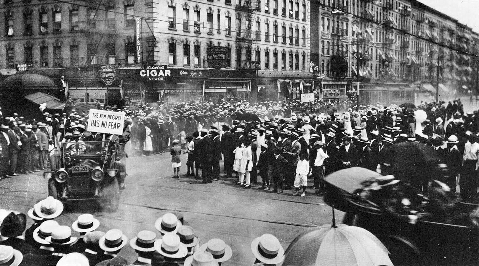
The Universal Negro Improvement Association and African Communities League (UNIA-ACL) is a black nationalist fraternal organization founded by Marcus Garvey, a Jamaican immigrant to the United States, and Amy Ashwood Garvey. The Pan-African organization enjoyed its greatest strength in the 1920s, and was influential prior to Garvey's deportation to Jamaica in 1927. After that its prestige and influence declined, but it had a strong influence on African-American history and development. The UNIA was said to be "unquestionably, the most influential anticolonial organization in Jamaica prior to 1938," according to Honor Ford-Smith. The organization was founded to work for the advancement of people of African ancestry around the world. Its motto is "One God! One Aim! One Destiny!" and its slogan is "Africa for the Africans, at home and abroad!" The broad mission of the UNIA-ACL led to the establishment of numerous auxiliary components, among them the African Legion (a paramilitary ... [...More Info...] [...Related Items...] OR: [Wikipedia] [Google] [Baidu] |
Marcus Garvey
Marcus Mosiah Garvey Sr. (17 August 188710 June 1940) was a Jamaican political activist, publisher, journalist, entrepreneur, and orator. He was the founder and first President-General of the Universal Negro Improvement Association and African Communities League (UNIA-ACL, commonly known as UNIA), through which he declared himself Provisional President of Africa. Ideologically a black nationalist and Pan-Africanist, his ideas came to be known as Garveyism. Garvey was born into a moderately prosperous Afro-Jamaican family in Saint Ann's Bay and he was apprenticed into the print trade as a teenager. Working in Kingston, he got involved in trade unionism before he lived briefly in Costa Rica, Panama, and England. After he returned to Jamaica, he founded the UNIA in 1914. In 1916, he moved to the United States and established a UNIA branch in New York City's Harlem district. Emphasising unity between Africans and the African diaspora, he campaigned for an end to European colonial ... [...More Info...] [...Related Items...] OR: [Wikipedia] [Google] [Baidu] |
African-American Neighborhood
African-American neighborhoods or black neighborhoods are types of ethnic enclaves found in many cities in the United States. Generally, an African American neighborhood is one where the majority of the people who live there are African American. Some of the earliest African-American neighborhoods were in New Orleans, Mobile, Atlanta, and other cities throughout the American South, as well as in New York City. In 1830, there were 14,000 " Free negroes" living in New York City. The formation of black neighborhoods is closely linked to the history of segregation in the United States, either through formal laws or as a product of social norms. Despite the formal laws and segregation, black neighborhoods have played an important role in the development of African-American culture. Black residential segregation has been declining in the United States and many black people are moving to white suburbs. Black people continue to live in poorer neighborhoods than white people and Americans ... [...More Info...] [...Related Items...] OR: [Wikipedia] [Google] [Baidu] |
World War I
World War I (28 July 1914 11 November 1918), often abbreviated as WWI, was one of the deadliest global conflicts in history. Belligerents included much of Europe, the Russian Empire, the United States, and the Ottoman Empire, with fighting occurring throughout Europe, the Middle East, Africa, the Pacific, and parts of Asia. An estimated 9 million soldiers were killed in combat, plus another 23 million wounded, while 5 million civilians died as a result of military action, hunger, and disease. Millions more died in genocides within the Ottoman Empire and in the 1918 influenza pandemic, which was exacerbated by the movement of combatants during the war. Prior to 1914, the European great powers were divided between the Triple Entente (comprising France, Russia, and Britain) and the Triple Alliance (containing Germany, Austria-Hungary, and Italy). Tensions in the Balkans came to a head on 28 June 1914, following the assassination of Archduke Franz Ferdin ... [...More Info...] [...Related Items...] OR: [Wikipedia] [Google] [Baidu] |
1989 Loma Prieta Earthquake
The 1989 Loma Prieta earthquake occurred on California's Central Coast on October 17 at local time. The shock was centered in The Forest of Nisene Marks State Park in Santa Cruz County, approximately northeast of Santa Cruz on a section of the San Andreas Fault System and was named for the nearby Loma Prieta Peak in the Santa Cruz Mountains. With an magnitude of 6.9 and a maximum Modified Mercalli intensity of IX (''Violent''), the shock was responsible for 63 deaths and 3,757 injuries. The Loma Prieta segment of the San Andreas Fault System had been relatively inactive since the 1906 San Francisco earthquake (to the degree that it was designated a seismic gap) until two moderate foreshocks occurred in June 1988 and again in August 1989. Damage was heavy in Santa Cruz County and less so to the south in Monterey County, but effects extended well to the north into the San Francisco Bay Area, both on the San Francisco Peninsula and across the bay in Oakland. No surface faultin ... [...More Info...] [...Related Items...] OR: [Wikipedia] [Google] [Baidu] |
16th Street Station (Oakland)
16th Street station (Oakland Central) is a former Southern Pacific Railroad station in the Prescott neighborhood of Oakland, California, United States. The Beaux-Arts building was designed by architect Jarvis Hunt, a preeminent railroad station architect, and opened in 1912. The station has not been served by trains since 1994. History Southern Pacific The original 16th Street depot was a smaller wood structure, built when the tracks were on the shoreline of San Francisco Bay. Later the shoreline was filled and now lies nearly a mile west. It was replaced in 1912 by a Beaux-Arts building designed by architect Jarvis Hunt. For decades the 16th Street station was the main Oakland station for Southern Pacific (SP) through trains, almost entirely replacing the 7th Street station. It was a companion (or "city station") for Oakland Pier, two miles away, where passengers could board ferries to San Francisco. (After 1958, the ferries were replaced by buses from 16th Street station ... [...More Info...] [...Related Items...] OR: [Wikipedia] [Google] [Baidu] |
1906 San Francisco Earthquake
At 05:12 Pacific Standard Time on Wednesday, April 18, 1906, the coast of Northern California was struck by a major earthquake with an estimated moment magnitude of 7.9 and a maximum Mercalli intensity of XI (''Extreme''). High-intensity shaking was felt from Eureka on the North Coast to the Salinas Valley, an agricultural region to the south of the San Francisco Bay Area. Devastating fires soon broke out in San Francisco and lasted for several days. More than 3,000 people died, and over 80% of the city was destroyed. The events are remembered as one of the worst and deadliest earthquakes in the history of the United States. The death toll remains the greatest loss of life from a natural disaster in California's history and high on the lists of American disasters. Tectonic setting The San Andreas Fault is a continental transform fault that forms part of the tectonic boundary between the Pacific Plate and the North American Plate. The strike-slip fault is characterized by ma ... [...More Info...] [...Related Items...] OR: [Wikipedia] [Google] [Baidu] |


