|
Welbury Railway Station
Welbury railway station was a railway station serving the village of Welbury in North Yorkshire, England. Located on the Northallerton to Eaglescliffe Line (now part of the ''North TransPennine'' route) it was opened on 2 June 1852 by the Leeds Northern Railway. It closed to passengers on 20 September 1954 and closed completely in 1963. The station was located north of Northallerton station and south of Eaglescliffe. The line is still open for passenger and freight trains, with TransPennine Express TransPennine Express (TPE), legally First TransPennine Express Limited, is a British train operating company owned by FirstGroup that operates the TransPennine Express franchise. It runs regional and inter-city rail services between the major c ... providing an hourly service between , and and Grand Central providing five trains per day in each direction between and . Freight is mostly, steel, coal and biomass run by several operators. There is a level crossing at Welbur ... [...More Info...] [...Related Items...] OR: [Wikipedia] [Google] [Baidu] |
Hambleton District
Hambleton is a local government district in North Yorkshire, England. The administrative centre is Northallerton, and the district includes the outlying towns and villages of Bedale, Thirsk, Great Ayton, Stokesley, and Easingwold. The district was formed by the Local Government Act 1972 on 1 April 1974, as a merger of Northallerton Urban District, Bedale Rural District, Easingwold Rural District, Northallerton Rural District, and parts of Thirsk Rural District, Stokesley Rural District and Croft Rural District, all in the North Riding of Yorkshire. Geography Hambleton covers an area of 1,311.17 km² most of which, 1,254.90 km², is green space. The district is named after the Hambleton Hills, part of the North York Moors National Park, on the eastern edge of the district. This area is the subject of a national habitat protection scheme as articulated in the United Kingdom's Biodiversity Action Plan. About 75% of the district lies in the Vales of Mowbray and of ... [...More Info...] [...Related Items...] OR: [Wikipedia] [Google] [Baidu] |
Northallerton Railway Station
Northallerton railway station is on the East Coast Main Line serving the town of Northallerton in North Yorkshire, England. It is north of between to the south and to the north. Its three-letter station code is NTR. The station is managed by TransPennine Express (TPE) and also served by Grand Central (GC) and London North Eastern Railway (LNER) trains. The station is on one of the fastest parts of the East Coast Main Line. LNER and CrossCountry express services pass through the station at speeds of up to . In 2014 the Wensleydale Railway opened a temporary station at . The heritage railway aims to run trains into the station from and eventually on the Settle–Carlisle line. History The station was opened by the Great North of England Railway on 30 March 1841. Eleven years later the Leeds Northern Railway's line from Leeds to Stockton passed through the town, but did not initially connect with the main line. Instead trains called at nearby ''Northallerton Town'' statio ... [...More Info...] [...Related Items...] OR: [Wikipedia] [Google] [Baidu] |
Railway Stations In Great Britain Closed In 1954
Rail transport (also known as train transport) is a means of transport that transfers passengers and goods on wheeled vehicles running on rails, which are incorporated in Track (rail transport), tracks. In contrast to road transport, where the vehicles run on a prepared flat surface, rail vehicles (rolling stock) are directionally guided by the tracks on which they run. Tracks usually consist of steel rails, installed on Railroad tie, sleepers (ties) set in track ballast, ballast, on which the rolling stock, usually fitted with metal wheels, moves. Other variations are also possible, such as "slab track", in which the rails are fastened to a concrete foundation resting on a prepared subsurface. Rolling stock in a rail transport system generally encounters lower friction, frictional resistance than rubber-tyred road vehicles, so passenger and freight cars (carriages and wagons) can be coupled into longer trains. The rail transport operations, operation is carried out by a ... [...More Info...] [...Related Items...] OR: [Wikipedia] [Google] [Baidu] |
Railway Stations In Great Britain Opened In 1852
Rail transport (also known as train transport) is a means of transport that transfers passengers and goods on wheeled vehicles running on rails, which are incorporated in Track (rail transport), tracks. In contrast to road transport, where the vehicles run on a prepared flat surface, rail vehicles (rolling stock) are directionally guided by the tracks on which they run. Tracks usually consist of steel rails, installed on Railroad tie, sleepers (ties) set in track ballast, ballast, on which the rolling stock, usually fitted with metal wheels, moves. Other variations are also possible, such as "slab track", in which the rails are fastened to a concrete foundation resting on a prepared subsurface. Rolling stock in a rail transport system generally encounters lower friction, frictional resistance than rubber-tyred road vehicles, so passenger and freight cars (carriages and wagons) can be coupled into longer trains. The rail transport operations, operation is carried out by a ... [...More Info...] [...Related Items...] OR: [Wikipedia] [Google] [Baidu] |
Northallerton–Eaglescliffe Line
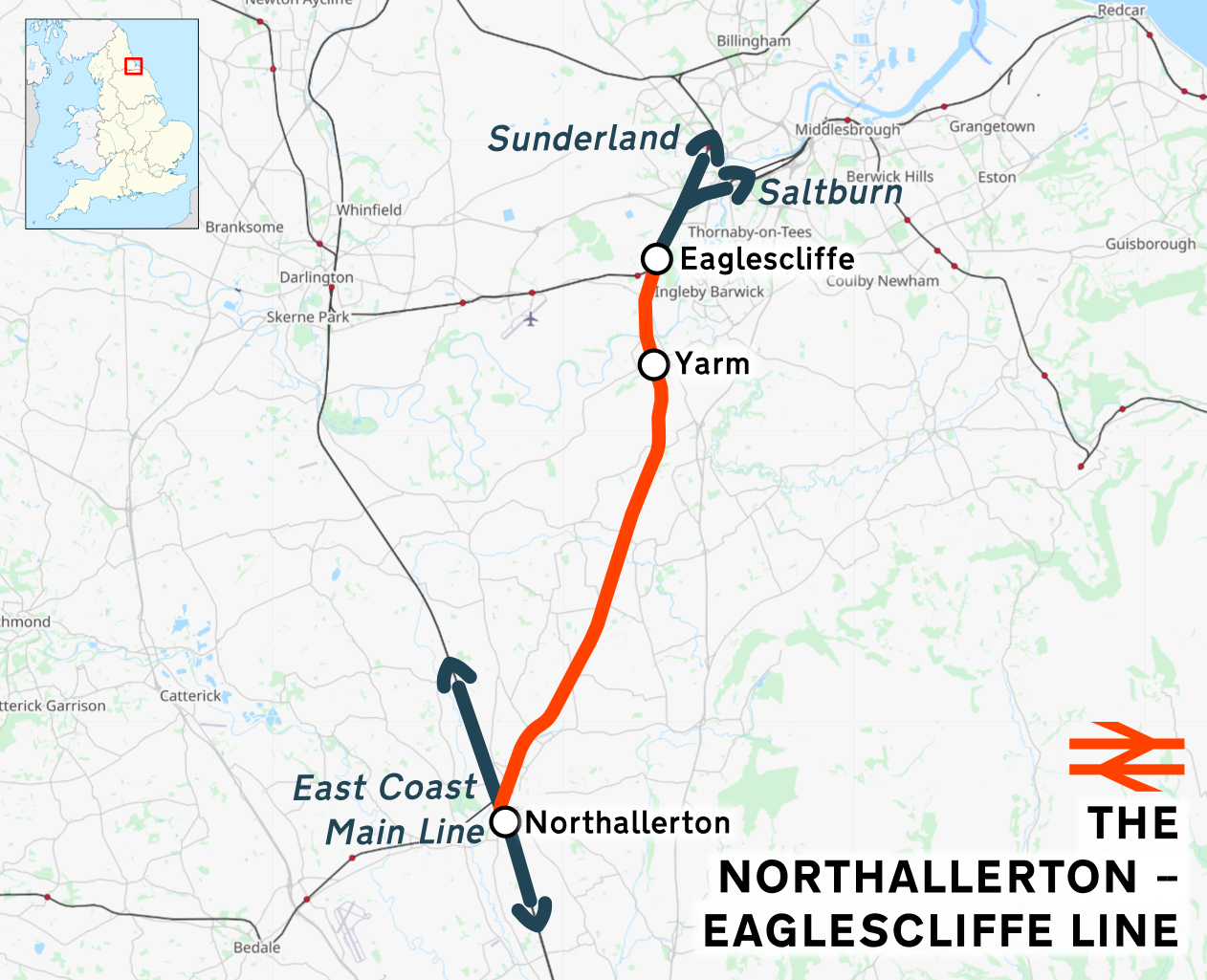
The Northallerton–Eaglescliffe line runs between and stations. It connects the East Coast Main Line to the Tees Valley Line. It was built by the Leeds Northern Railway as part of their main line from to (via and ) which opened on 2 June 1852, although the connection to the ECML at the Northallerton end was not opened for a further four years. Stations Open The current stations on the line are: *Northallerton railway station, Northallerton *Yarm railway station, Yarm *Eaglescliffe railway station, Eaglescliffe Closed A number of stations that used to serve towns and villages on the line were closed between 1954 and the end of local passenger services over the route on 6 September 1965, with those at Picton, Yarm and Brompton being the last to go. The station at Yarm was subsequently reopened by Arriva Trains Northern, Regional Railways North East in February 1996. Services Most services are run by TransPennine Express between Manchester Airport and Middlesbrough. Servi ... [...More Info...] [...Related Items...] OR: [Wikipedia] [Google] [Baidu] |
Grand Central (train Operating Company)
Grand Central is an open-access train operating company in the United Kingdom. Presently a subsidiary of Arriva UK Trains, it has operated passenger rail services since December 2007. The company was founded in April 2000 as ''Grand Central Railway Company Ltd''. Three years later, the company applied to the Office of Rail Regulation (ORR) to operate a two-hourly open-access service from Newcastle via the Caldervale Line and Manchester Victoria to Bolton, which was rejected. In February 2005, Grand Central successfully applied to operate four daily services from Sunderland to London King's Cross and four daily services from Bradford Interchange to London King's Cross. During December 2007, Grand Central launched its first services on the East Coast Main Line, running between Sunderland and London King's Cross. Following the delivery and refurbishment of additional rolling stock, its full timetable was introduced during March 2008. During March 2008, Grand Central successf ... [...More Info...] [...Related Items...] OR: [Wikipedia] [Google] [Baidu] |
TransPennine Express
TransPennine Express (TPE), legally First TransPennine Express Limited, is a British train operating company owned by FirstGroup that operates the TransPennine Express franchise. It runs regional and inter-city rail services between the major cities and towns of Northern England and Scotland. The franchise operates almost all its services to and through Manchester covering three main routes. The service provides rail links for major towns and cities such as Edinburgh, Glasgow, Liverpool, Sheffield, Hull, Leeds, York, Scarborough, Middlesbrough and Newcastle. TPE run trains 24 hours a day, including through New Year's Eve night. TPE trains run between , and at least every three hours every night of the week. The franchise operates across the West Coast Main Line, Huddersfield Line, East Coast Main Line and part of the Tees Valley line. The majority of TPE's rolling stock was procured during the late 2010s under ''Project Nova''. These consist of the ''Nova 1'' () BMU trainse ... [...More Info...] [...Related Items...] OR: [Wikipedia] [Google] [Baidu] |
Wellingborough
Wellingborough ( ) is a large market and commuter town in the unitary authority area of North Northamptonshire in the ceremonial county of Northamptonshire, England, 65 miles from London and from Northampton on the north side of the River Nene. Originally named "Wendelingburgh" (the stronghold of Wændel's people), the Anglo-Saxon settlement is mentioned in the Domesday Book of 1086 as "Wendelburie". The town was granted a royal market charter in 1201 by King John. At the 2011 census, the town's built-up area had a population of 50,577. The Wellingborough built-up area also includes suburbs Wilby, Great Doddington, Little Irchester and Redhill Grange. History The town was established in the Anglo-Saxon period and was called "Wendelingburgh". It is surrounded by five wells: Redwell, Hemmingwell, Witche's Well, Lady's Well and Whytewell, which appear on its coat of arms. Henrietta Maria came with her physician Théodore de Mayerne to take the waters on 14 July 1627. The m ... [...More Info...] [...Related Items...] OR: [Wikipedia] [Google] [Baidu] |
Ordnance Survey National Grid
The Ordnance Survey National Grid reference system (OSGB) (also known as British National Grid (BNG)) is a system of geographic grid references used in Great Britain, distinct from latitude and longitude. The Ordnance Survey (OS) devised the national grid reference system, and it is heavily used in their survey data, and in maps based on those surveys, whether published by the Ordnance Survey or by commercial map producers. Grid references are also commonly quoted in other publications and data sources, such as guide books and government planning documents. A number of different systems exist that can provide grid references for locations within the British Isles: this article describes the system created solely for Great Britain and its outlying islands (including the Isle of Man); the Irish grid reference system was a similar system created by the Ordnance Survey of Ireland and the Ordnance Survey of Northern Ireland for the island of Ireland. The Universal Transverse Merca ... [...More Info...] [...Related Items...] OR: [Wikipedia] [Google] [Baidu] |
Northallerton To Eaglescliffe Line
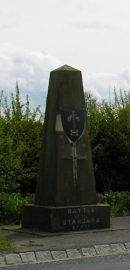
Northallerton ( ) is a market town and civil parish in the Hambleton District of North Yorkshire, England. It lies in the Vale of Mowbray and at the northern end of the Vale of York. It had a population of 16,832 in the 2011 census, an increase from 15,741 in 2001. It has served as the county town of the North Riding of Yorkshire and, since 1974, of North Yorkshire. Northallerton is made up of four wards: North, Broomfield, Romanby and Central. There has been a settlement at Northallerton since Roman times; however its growth in importance began in the 11th century when King William II gifted land to the Bishop of Durham. Under the Bishop's authority Northallerton became an important religious centre. Later, it was a focus for much conflict between the English and the Scots, most notably the Battle of the Standard, fought nearby in 1138, which saw losses of as many as 12,000 men. In later years trade and transport became more important. The surrounding area was discovered to ... [...More Info...] [...Related Items...] OR: [Wikipedia] [Google] [Baidu] |


