|
Warren County (other)
Warren County is the name of fourteen counties in the USA. Some are named after General Joseph Warren, who was killed in the Battle of Bunker Hill in the American Revolutionary War: * Warren County, Georgia * Warren County, Illinois * Warren County, Indiana * Warren County, Iowa * Warren County, Kentucky * Warren County, Mississippi * Warren County, Missouri * Warren County, New Jersey * Warren County, New York * Warren County, North Carolina * Warren County, Ohio - The most populated county with the name. * Warren County, Pennsylvania * Warren County, Tennessee Warren County is a county located on the Cumberland Plateau in Middle Tennessee, one of the three Grand Divisions of the U.S. state of Tennessee. As of the 2010 census, the population was 39,839. Its county seat is McMinnville. Warren County c ... * Warren County, Virginia {{geodis, uscounty ... [...More Info...] [...Related Items...] OR: [Wikipedia] [Google] [Baidu] |
Joseph Warren
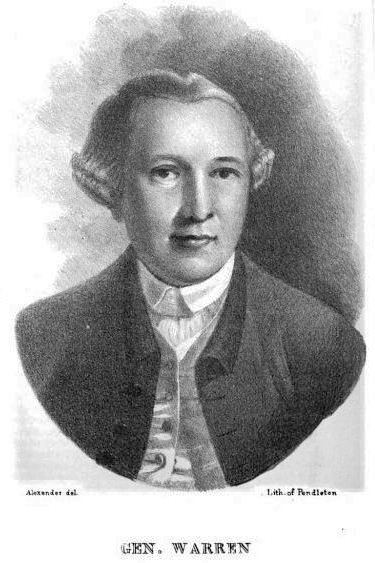
Joseph Warren (June 11, 1741 – June 17, 1775), a Founding Father of the United States, was an American physician who was one of the most important figures in the Patriot movement in Boston during the early days of the American Revolution, eventually serving as President of the revolutionary Massachusetts Provincial Congress. Warren enlisted Paul Revere and William Dawes on April 18, 1775, to leave Boston and spread the alarm that the British garrison in Boston was setting out to raid the town of Concord and arrest rebel leaders John Hancock and Samuel Adams. Warren participated in the Battles of Lexington and Concord the following day, the opening engagements of the American Revolutionary War. Warren had been commissioned a major general in the colony's militia shortly before the June 17, 1775 Battle of Bunker Hill. Rather than exercise his rank, Warren chose to participate in the battle as a private soldier, and was killed in combat when British troops stormed the redoubt ... [...More Info...] [...Related Items...] OR: [Wikipedia] [Google] [Baidu] |
Battle Of Bunker Hill
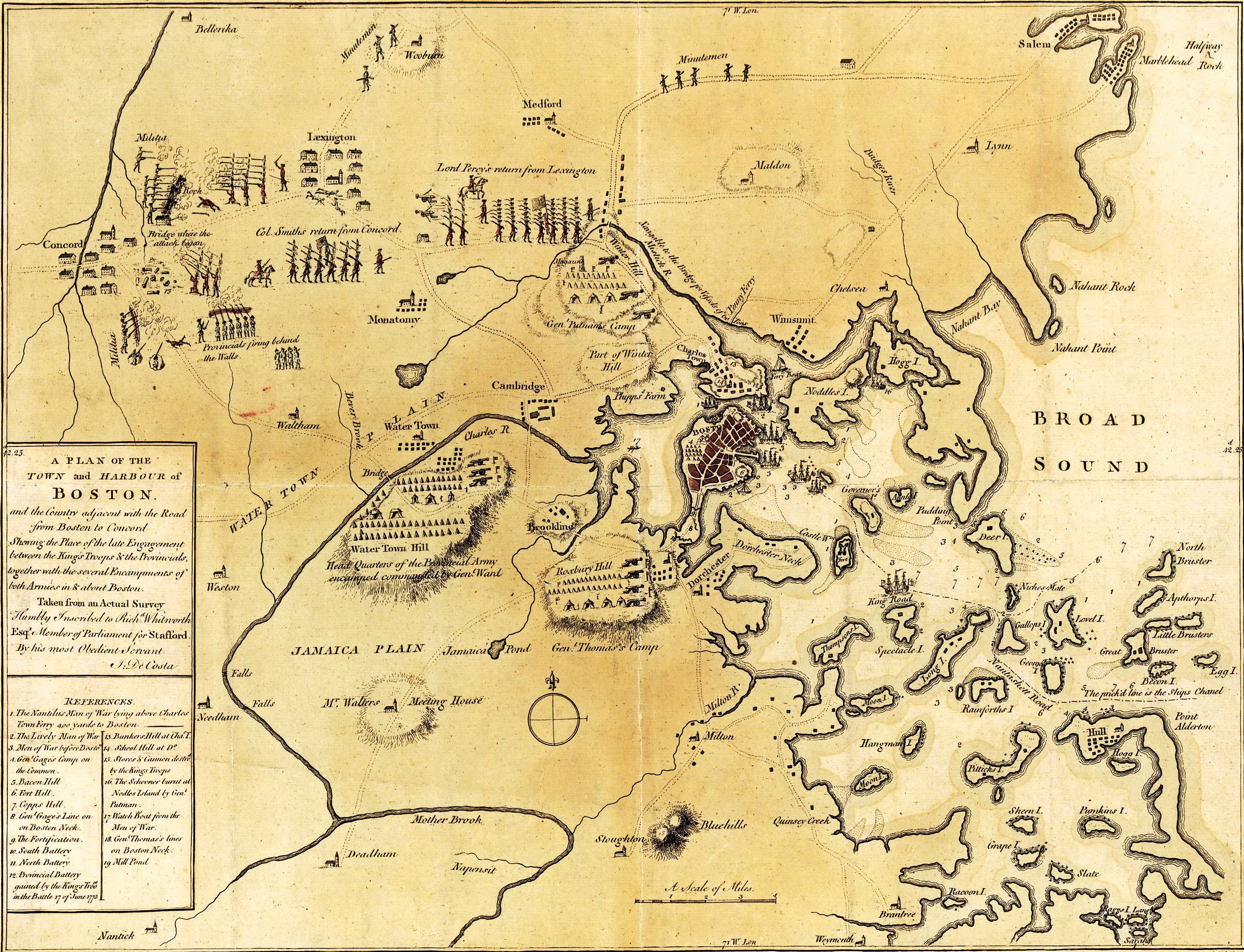
The Battle of Bunker Hill was fought on June 17, 1775, during the Siege of Boston in the first stage of the American Revolutionary War. The battle is named after Bunker Hill in Charlestown, Massachusetts, which was peripherally involved in the battle. It was the original objective of both the colonial and British troops, though the majority of combat took place on the adjacent hill which later became known as Breed's Hill. On June 13, 1775, the leaders of the colonial forces besieging Boston learned that the British were planning to send troops out from the city to fortify the unoccupied hills surrounding the city, which would give them control of Boston Harbor. In response, 1,200 colonial troops under the command of William Prescott stealthily occupied Bunker Hill and Breed's Hill. During the night, the colonists constructed a strong redoubt on Breed's Hill, as well as smaller fortified lines across the Charlestown Peninsula. By daybreak of June 17, the British became a ... [...More Info...] [...Related Items...] OR: [Wikipedia] [Google] [Baidu] |
American Revolutionary War
The American Revolutionary War (April 19, 1775 – September 3, 1783), also known as the Revolutionary War or American War of Independence, was a major war of the American Revolution. Widely considered as the war that secured the independence of the United States, fighting began on April 19, 1775, followed by the Lee Resolution on July 2, 1776, and the Declaration of Independence on July 4, 1776. The American Patriots were supported by the Kingdom of France and, to a lesser extent, the Dutch Republic and the Spanish Empire, in a conflict taking place in North America, the Caribbean, and the Atlantic Ocean. Established by royal charter in the 17th and 18th centuries, the American colonies were largely autonomous in domestic affairs and commercially prosperous, trading with Britain and its Caribbean colonies, as well as other European powers via their Caribbean entrepôts. After British victory over the French in the Seven Years' War in 1763, tensions between the motherland and he ... [...More Info...] [...Related Items...] OR: [Wikipedia] [Google] [Baidu] |
Warren County, Georgia
Warren County is a county located in the U.S. state of Georgia. As of the 2020 United States census, the population was 5,215, a decrease from 2010. The county seat is Warrenton. The county was created on December 19, 1793, and is named after General Joseph Warren, who was killed in the Battle of Bunker Hill. Geography According to the U.S. Census Bureau, the county has a total area of , of which is land and (0.8%) is water. The north-to-northeastern quarter of Warren County, north of a line between the county's northwestern corner, Norwood, and Camak, is located in the Little River sub-basin of the Savannah River basin. The southeastern quarter, from Camak in the north, and bordered by a northwest-to-southeast line running through Warrenton, is located in the Brier Creek sub-basin of the larger Savannah River basin. The western half of the county, west of Warrenton, is located in the Upper Ogeechee River sub-basin of the Ogeechee River basin. Major highways * Intersta ... [...More Info...] [...Related Items...] OR: [Wikipedia] [Google] [Baidu] |
Warren County, Illinois
Warren County is a county in the U.S. state of Illinois. According to the 2010 census, it had a population of 17,707. Its county seat is Monmouth. History Warren County was organized in 1825 out of Pike County which consisted of all portions of the state north and west of the Illinois River before 1825. Henderson County was formed in 1841 from the western area of Warren County. Warren County was named for Dr. Joseph Warren, killed at the Battle of Bunker Hill in 1775. He is believed to have been the first officer to die in the Revolutionary War. The current courthouse, constructed of red Portage stone, was completed in 1895. File:Warren County Illinois 1825.png, Warren County from the time of its creation to 1831 File:Warren County Illinois 1831.png, Between 1831 and 1835, Mercer County was temporarily attached to Warren until it could organize its own county government.White, Jesse. Origin and Evolution of Illinois Counties'. State of Illinois, March 2010. File:Warren_Co ... [...More Info...] [...Related Items...] OR: [Wikipedia] [Google] [Baidu] |
Warren County, Indiana
Warren County is a county in the U.S. state of Indiana. It lies in the western part of the state between the Illinois state line and the Wabash River. According to the 2010 census, it had a population of 8,440. Its county seat is Williamsport. Before the arrival of non-indigenous settlers in the early 19th century, the area was inhabited by several Native American tribes. The county was officially established in 1827 and was the 55th county to be formed in Indiana. It is one of the most rural counties in the state, with the third-smallest population and the lowest population density at about . The county has four incorporated towns with a total population of about 3,100, as well as many small unincorporated communities. The county is divided into 12 townships which provide local services. Much of the land in the county is given over to agriculture, especially on the open prairie in the northern and western parts; the county's farmland is among the most productive in ... [...More Info...] [...Related Items...] OR: [Wikipedia] [Google] [Baidu] |
Warren County, Iowa
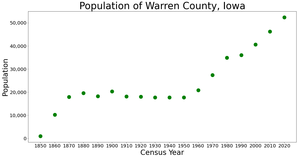
Warren County is a rural county located in the U.S. state of Iowa. As of the 2020 census, the population was 52,403. The county seat is Indianola. Warren County is included in the Des Moines–West Des Moines, IA Metropolitan Statistical Area. History Warren County was formed in 1846. It was named for General Joseph Warren, a hero in the American Revolutionary War. The present Warren County Court House was opened in 1939. Geography According to the U.S. Census Bureau, the county has a total area of , of which is land and (0.6%) is water. Major highways * Interstate 35 * U.S. Highway 65 * U.S. Highway 69 * Iowa Highway 5 * Iowa Highway 28 * Iowa Highway 92 * Iowa Highway 316 Adjacent counties *Polk County (north) * Marion County (east) * Lucas County (southeast) *Clarke County (southwest) * Madison County (west) Demographics 2020 census The 2020 census recorded a population of 52,403 in the county, with a population density of . 95.46% of the population ... [...More Info...] [...Related Items...] OR: [Wikipedia] [Google] [Baidu] |
Warren County, Kentucky
Warren County is a county located in the south central portion of the U.S. state of Kentucky. As of the 2020 census, the population was 134,554, making it the fifth-most populous county in Kentucky. The county seat is Bowling Green. Warren County is now classified as a wet county after voters approved the measure in 2018. The measure became law in January 2019 that allows alcohol to be sold county wide. Warren County is included in the Bowling Green, KY Metropolitan Statistical Area. It is located in the Pennyroyal Plateau and Western Coal Fields regions. History Warren County was the location of several Native American villages and ancient burial mounds constructed by earlier cultures. The first white men to enter the area were the long hunters in the 1770s. General Elijah Covington was among the first landowners. McFadden's Station, one of the earliest settlements, was established in 1785 by Andrew McFadden/McFadin on the northern bank of the Barren River at the Cumberlan ... [...More Info...] [...Related Items...] OR: [Wikipedia] [Google] [Baidu] |
Warren County, Mississippi
Warren County is a county located in the U.S. state of Mississippi. As of the 2010 census, the population was 48,773. Its county seat is Vicksburg. Created by legislative act of December 22, 1809, Warren County is named for American Revolutionary War officer Joseph Warren. Part of the Mississippi Delta and the historic cotton culture, Warren County is included in the Vicksburg, MS Micropolitan Statistical Area, which is also included in the Jackson-Vicksburg- Brookhaven, MS Combined Statistical Area. Geography According to the U.S. Census Bureau, the county has a total area of , of which is land and (4.9%) is water. The county exists in two sections, connected only by a narrow 500ft wide section between Madison Parish, Louisiana and Issaquena County, Mississippi along the delta of the Yazoo River. This area was once along the Mississippi River, but has since become an oxbow lake and marsh and no roads traverse this strip of land. The community of Eagle Bend is in this are ... [...More Info...] [...Related Items...] OR: [Wikipedia] [Google] [Baidu] |
Warren County, Missouri
Warren County is a county located in the eastern portion of the U.S. state of Missouri. As of the 2010 census, the population was 32,513. The county is located on the north side of the Missouri River. Its county seat is Warrenton. The county was organized on January 5, 1833; it was named for General Joseph Warren, who died in the Battle of Bunker Hill during the American Revolutionary War. Warren County is part of the St. Louis, MO- IL Metropolitan Statistical Area. The county is traversed by Route 94, called the "Missouri Weinstrasse" because of the many vineyards from Marthasville east into St. Charles County. Warren County is also part of the Missouri Rhineland, with award-winning wineries located on both sides of the Missouri River. Geography According to the U.S. Census Bureau, the county has a total area of , of which is land and (2.1%) is water. Adjacent counties * Lincoln County (north) *St. Charles County (east) * Franklin County (south) * Gasconade County (south ... [...More Info...] [...Related Items...] OR: [Wikipedia] [Google] [Baidu] |
Warren County, New Jersey
Warren County is a county located in the U.S. state of New Jersey. As of the 2020 U.S. census, the county's population was 109,632, representing an increase of 940 (0.9%) from the 108,692 residents counted at the 2010 census. The county borders the Delaware River and Easton, Pennsylvania in the Lehigh Valley to its west, the New York City metropolitan area to its east, and The Poconos to its northwest. Warren County is the only county in New Jersey which is not part of the combined statistical areas of New York City or Philadelphia. The most populous place is Phillipsburg, with 14,950 residents at the time of the 2010 census while Hardwick Township had both the largest area and the fewest people with 1,696 residents. Its county seat is Belvidere.New Jersey County Map , |
Warren County, New York
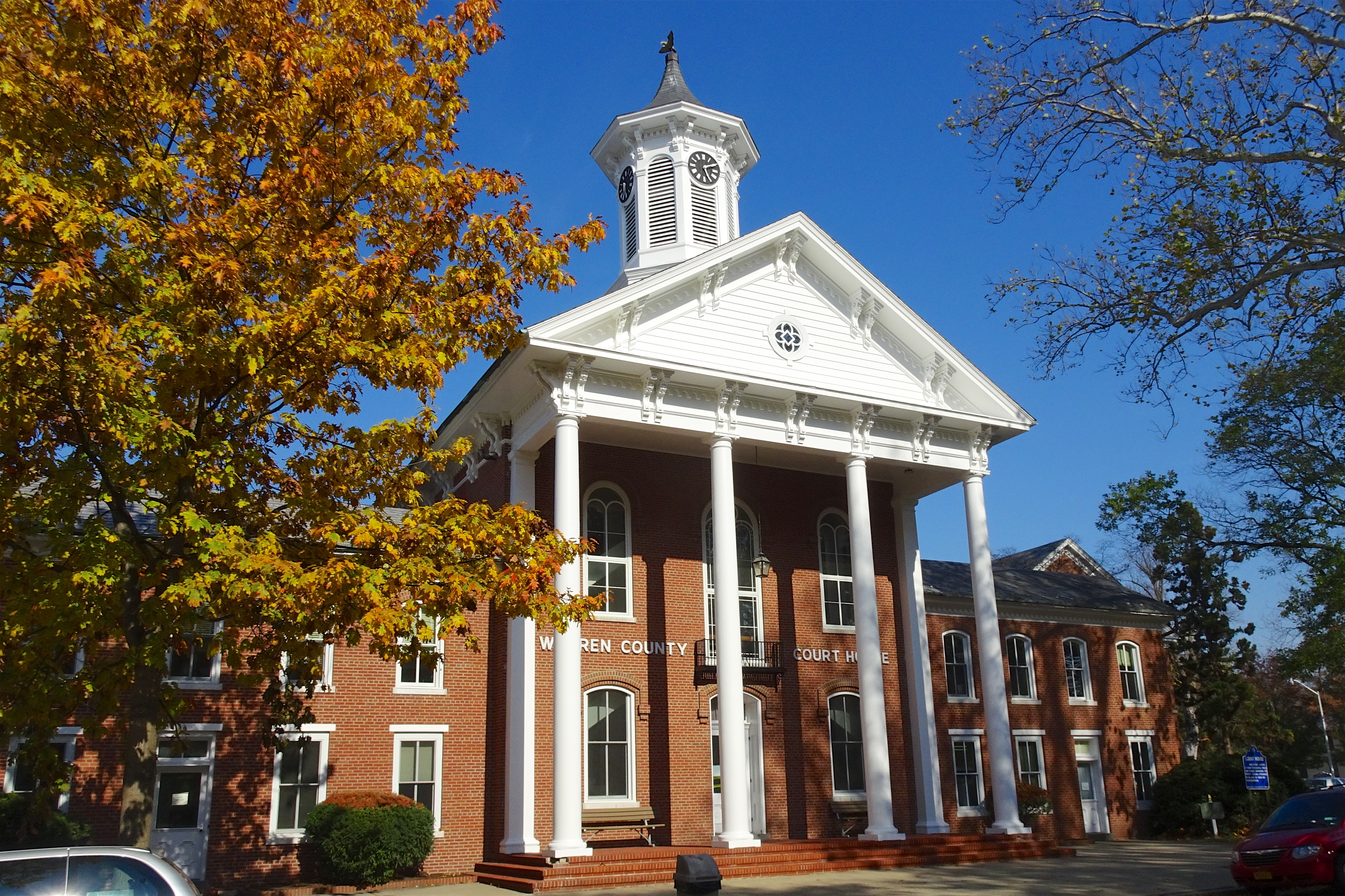
Warren County is a county in the U.S. state of New York. As of the 2020 census, the population was 65,737. The county seat is Queensbury. The county is named in honor of General Joseph Warren, an American Revolutionary War hero of the Battle of Bunker Hill. Warren County is part of the Glens Falls, NY Metropolitan Statistical Area, which is also included in the Albany-Schenectady, NY Combined Statistical Area. History When counties were established in the Province of New York in 1683, the present Warren County was part of Albany County. The county was enormous, covering the northern part of New York State, all of the present State of Vermont, and, in theory, extended westward to the Pacific Ocean. It was reduced in size on July 3, 1766, by the creation of Cumberland County, and further on March 16, 1770, by the creation of Gloucester County, both containing territory now in Vermont. On March 12, 1772, what was left of Albany County was split into three parts, one remai ... [...More Info...] [...Related Items...] OR: [Wikipedia] [Google] [Baidu] |


