|
Wanlockhead
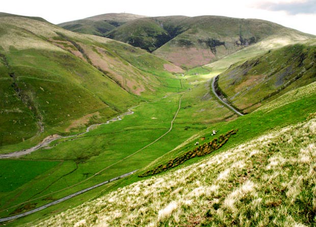
Wanlockhead is a village in Dumfries and Galloway, Scotland, nestling in the Lowther Hills and south of Leadhills at the head of the Mennock Pass, which forms part of the Southern Uplands. It is Scotland's highest village, at an elevation of around , and can be accessed via the B797, which connects it to the A76 near Sanquhar and the A74(M) motorway at Abington. History The village was called ''Winlocke'' until 1566, derived from the Gaelic ''Cuingealach'' (the narrow pass). Wanlockhead owes its existence to the lead and other mineral deposits in the surrounding hills. These deposits were first exploited by the Romans, and from the 13th century they began to be worked again in the summer. The village was founded permanently in 1680 when the Duke of Buccleuch built a lead smelting plant and workers' cottages. Lead, zinc, copper and silver were mined nearby, as well as some of the world's purest gold at 22.8 carats, which was used to make the Scottish Crown. Early gold m ... [...More Info...] [...Related Items...] OR: [Wikipedia] [Google] [Baidu] |
Leadhills
Leadhills, originally settled for the accommodation of miners, is a village in South Lanarkshire, Scotland, WSW of Elvanfoot. The population in 1901 was 835. It was originally known as Waterhead. It is the second highest village in Scotland, the highest being neighbouring Wanlockhead, south. It is near the source of Glengonnar Water, a tributary of the River Clyde. Local attractions Library The Leadhills Miners' Library (also known as the Allan Ramsay Library or the Leadhills Reading Society), founded in 1741 by 21 miners, the local schoolteacher and the local minister, specifically to purchase a collection of books for its members’ mutual improvement — its membership was not restricted to the miners; several non-miners, such as William Symington, John Brown (author of ''Rab and his Friends'') and James Braid, were also full members — houses an extensive antiquarian book collection, local relics, mining records and minerals. The library is the oldest subscription ... [...More Info...] [...Related Items...] OR: [Wikipedia] [Google] [Baidu] |
Leadhills & Wanlockhead Railway
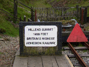
The Leadhills and Wanlockhead Railway is a narrow gauge railway in South Lanarkshire, Scotland. It is laid on the trackbed of the former Leadhills and Wanlockhead Branch of the Caledonian Railway which led off the main line between and Glasgow at Elvanfoot. Overview The preserved section runs from Leadhills for about towards Wanlockhead and is the highest adhesion railway in the UK. The rack and pinion Snowdon Mountain Railway is higher. Trains are currently diesel worked with the locomotive propelling the train up hill away from Leadhills. The original railway closed in the late 1930s shortly after the mines in Wanlockhead had closed. The railway currently stops at the border of South Lanarkshire and Dumfries and Galloway. Operation Trains operate on the push-pull principle as there are no run round loop facilities at the end of the run. Movements within the main station site at Leadhills are controlled from the reconstructed signal box which contains the origin ... [...More Info...] [...Related Items...] OR: [Wikipedia] [Google] [Baidu] |
Lowther Hills
The Lowther Hills, also sometimes known as the Lowthers, are an extensive area of hill country in the Southern Uplands of Scotland, though some sub-ranges of hills in this area also go under their own local names - see "Hillwalking" below. They form a roughly rhomboidal or lozenge shape on the map with the acute angles being to north and south. It has river valleys along its boundaries to north east (Clydesdale) and south west ( Nithsdale) which carry the two largest arterial routes northwards into the west side of the Central Belt of Scotland. A string of small towns have long since developed along these routes. Most of the Lowther Hills lie in the Administrative County of Dumfries and Galloway, though part in the administrative county of South Lanarkshire moves into them around the village of Leadhills and the Daer Reservoir. Etymology There is some obscurity surrounding the name ''Lowther''. Derivation from the early Irish ''lothur'' meaning "a canal, a trench", in this sen ... [...More Info...] [...Related Items...] OR: [Wikipedia] [Google] [Baidu] |
Mennock Lye Goods Depot
Mennock Lye Goods Depot or Mennock Siding was a railway freight facility located off the A76 in the hamlet of Mennock that lies circa two miles (three km) south-east of Sanquhar, Dumfries and Galloway, Scotland. Situated 68 miles (109 km) from Glasgow it served the industrial and agricultural requirements for transportation in the vicinity of Mennock and the surrounding rural area, originally on behalf of the Glasgow, Dumfries and Carlisle Railway. The goods depot was located on a section of line with a falling southbound gradient of 1 in 160.Sou' West. G&SWR Association. Number 190. Autumn 2020. p.5 No passenger railway station has been recorded for Mennock. Although a remote location today the facility would have served freight transport requirements in the form of such items as lime for the fields, cattle, horse and sheep movements, milk delivery, coal transport movements and related items, etc. The Glasgow, Dumfries and Carlisle Railway opened sidings at Mennock fo ... [...More Info...] [...Related Items...] OR: [Wikipedia] [Google] [Baidu] |
Cornelius De Vos
Cornelius de Vos or de Vois or Devosse ( fl. 1565-1585), was a Dutch or Flemish mine entrepreneur and mineral prospector working in England and Scotland. He was said to have been a "picture-maker" or portrait artist. De Vos is known for gold mining in Scotland and founding saltworks at Newhaven near Edinburgh. Career In 1558 Cornelius de Vos was in London, and married Helen, the widow of a butcher, Nicholas Howe, and John Gylmyne. He was recorded as a member of the French church in Farringdon in 1568. De Vos was granted rights to mine copperas and alum in England by letters patent in 1564. He seems to have mined alum on the Isle of Wight and in Devon, and pursued mining concessions in Ireland. According to his rival for Irish mining rights, William Humfrey, Cornelius de Vos obtained patents for mine drainage methods previously granted to Burchard Kranich. He worked for James Blount, 6th Baron Mountjoy at Canford Cliffs in Dorset, with little success. Searching for Scottish g ... [...More Info...] [...Related Items...] OR: [Wikipedia] [Google] [Baidu] |
Dumfriesshire
Dumfriesshire or the County of Dumfries or Shire of Dumfries (''Siorrachd Dhùn Phris'' in Gaelic) is a historic county and registration county in southern Scotland. The Dumfries lieutenancy area covers a similar area to the historic county. In terms of historic counties it borders Kirkcudbrightshire to the west, Ayrshire to the north-west, Lanarkshire, Peeblesshire and Selkirkshire to the north, and Roxburghshire to the east. To the south is the coast of the Solway Firth, and the English county of Cumberland. Dumfriesshire has three traditional subdivisions, based on the three main valleys in the county: Annandale, Eskdale and Nithsdale. These had been independent provinces in medieval times but were gradually superseded as administrative areas by the area controlled by the sheriff of Dumfries, or Dumfriesshire. A Dumfriesshire County Council existed from 1890 until 1975. Since 1975, the area of the historic county has formed part of the Dumfries and Galloway council ... [...More Info...] [...Related Items...] OR: [Wikipedia] [Google] [Baidu] |
Sanquhar
Sanquhar ( sco, Sanchar, gd, Seanchair) is a village on the River Nith in Dumfries and Galloway, Scotland, north of Thornhill and west of Moffat. It is a former Royal Burgh. It is notable for its tiny post office, established in 1712 and considered the oldest working post office in the world. It was also where the Covenanters, who opposed episcopalisation of the church, signed the ''Sanquhar Declaration'' renouncing their allegiance to the King, an event commemorated by a monument in the main street. The church of St Brides contains a memorial to James Crichton, a 16th-century polymath. The ruins of Sanquhar Castle stand nearby. Nithsdale Wanderers, the local football team, were formed in 1897. In 1924–25, they won the Scottish Division Three. History The name "Sanquhar" comes from the Scottish Gaelic language ''An t-Seanchair'', meaning "old fort". A 15th-century castle ruin overlooks the town, but the name predates even this ancient fort. The antiquary, William Fo ... [...More Info...] [...Related Items...] OR: [Wikipedia] [Google] [Baidu] |
Bevis Bulmer
Sir Bevis Bulmer (1536–1615) was an English mining engineer during the reigns of Elizabeth I and James I. He has been called "one of the great speculators of that era". Many of the events in his career were recorded by Stephen Atkinson in ''The Discoveries and Historie of the Gold Mynes in Scotland'', compiled in part from a lost manuscript by Bulmer entitled ''Bulmer's Skill''. Family According to Tyson, Bevis Bulmer's "origins are shrouded in mystery". However according to other sources, Bevis Bulmer, born in 1536, was the son of Sir John Bulmer, eldest son and heir of Sir William Bulmer (d.1531).Bulmer, Sir William (by 1465–1531), of Wilton, Yorkshire, History of Parliament Retrieved 30 October 2013. His mother was ... [...More Info...] [...Related Items...] OR: [Wikipedia] [Google] [Baidu] |
George Bowes (prospector)
George Bowes (died 1606) prospected and mined for gold in Scotland. George was a son of Sir George Bowes of Streatlam and Dorothy Mallory. He married Magdalen Bray, daughter of Sir Edward Bray. Coal and copper In 1595 he planned a coal mine on his own estate of Biddick or Beddick Waterville. In 1602 he was allowed to mine for copper in the Knowsley estate belonging to the Earl of Derby. At Caldbeck near Keswick, in 1602, Bowes and Francis Needham reported on old copper workings and lead which contained a proportion of silver. Surveying the gold fields in 1603 Bowes became interested in mining for gold in Scotland, probably hearing of the work of George Douglas of Parkhead and of Cornelius de Vos who had strong links with the mines in Keswick. He wrote in 1603 that James VI had invited him to come to Scotland twice before the Union of the Crowns, by means of his uncle, the ambassador Robert Bowes. He wrote a paper describing his reasons for seeking gold on Crawford Moor. ... [...More Info...] [...Related Items...] OR: [Wikipedia] [Google] [Baidu] |
Dumfries And Galloway
Dumfries and Galloway ( sco, Dumfries an Gallowa; gd, Dùn Phrìs is Gall-Ghaidhealaibh) is one of 32 unitary council areas of Scotland and is located in the western Southern Uplands. It covers the historic counties of Dumfriesshire, Kirkcudbrightshire, and Wigtownshire, the latter two of which are collectively known as Galloway. The administrative centre and largest settlement is the town of Dumfries. The second largest town is Stranraer, on the North Channel coast, some to the west of Dumfries. Following the 1975 reorganisation of local government in Scotland, the three counties were joined to form a single region of Dumfries and Galloway, with four districts within it. The districts were abolished in 1996, since when Dumfries and Galloway has been a unitary local authority. For lieutenancy purposes, the area is divided into three lieutenancy areas called Dumfries, Wigtown and the Stewartry of Kirkcudbright, broadly corresponding to the three historic counties. ... [...More Info...] [...Related Items...] OR: [Wikipedia] [Google] [Baidu] |
A76 Road
The A76 is a major trunk road in south west Scotland. Starting at Kilmarnock in East Ayrshire, the A76 goes through or immediately by-passes Hurlford, Mauchline, Auchinleck, Cumnock, Pathhead and New Cumnock before entering Dumfries and Galloway and continuing through Kirkconnel, Sanquhar, Mennock, Enterkinfoot, Carronbridge, Thornhill, Closeburn, Kirkpatrick, Auldgirth and Holywood before terminating at Dumfries. For the majority of its length (the portion from New Cumnock to Dumfries) it follows the valley of the River Nith which also lends its name to the historic district of Nithsdale Nithsdale (''Srath Nid'' in Scottish Gaelic), also known as Strathnith, Stranith or Stranit, is the strath or dale of the River Nith in southern Scotland. Nithsdale was one of the medieval provinces of Scotland. The provinces gradually lost th .... References Roads in Scotland Transport in East Ayrshire Transport in Dumfries and Galloway {{Scotland-road-stub ... [...More Info...] [...Related Items...] OR: [Wikipedia] [Google] [Baidu] |
Gold
Gold is a chemical element with the symbol Au (from la, aurum) and atomic number 79. This makes it one of the higher atomic number elements that occur naturally. It is a bright, slightly orange-yellow, dense, soft, malleable, and ductile metal in a pure form. Chemically, gold is a transition metal and a group 11 element. It is one of the least reactive chemical elements and is solid under standard conditions. Gold often occurs in free elemental (native state), as nuggets or grains, in rocks, veins, and alluvial deposits. It occurs in a solid solution series with the native element silver (as electrum), naturally alloyed with other metals like copper and palladium, and mineral inclusions such as within pyrite. Less commonly, it occurs in minerals as gold compounds, often with tellurium ( gold tellurides). Gold is resistant to most acids, though it does dissolve in aqua regia (a mixture of nitric acid and hydrochloric acid), forming a soluble tetrachloroau ... [...More Info...] [...Related Items...] OR: [Wikipedia] [Google] [Baidu] |


