|
Vefa
Vefa is part of the district of Fatih in Istanbul, and lies inside what was once the old walled city of Constantinople. It lies roughly northwest of the eastern section of the Aqueduct of Valens, and is rich in monuments, both Byzantine and Ottoman. It takes its name from the Muslim saint (wali) Shaykh Ebu’l Vefa who is buried locally in his own mosque and dergah. Vefa lies to the east of busy Atatürk Bulvari, the main road pushed through the old city by the French architect Henri Prost in the 1950s. Immediately to its north is the rundown area of Küçükpazarı while to the east is the Süleymaniye district around the huge Süleymaniye Mosque complex. Buses plough up and down Atatürk Bulvari linking Vefa to Taksim, Eminönü, Fatih and Beyazıt. The Vezneciler Metro stop on the M2 line is a short walk away as is the Cibali tram stop on the Golden Horn. Attractions Vefa is best known for the picturesque back-street Vefa Bozacısı shop, the oldest shop (founded in 18 ... [...More Info...] [...Related Items...] OR: [Wikipedia] [Google] [Baidu] |
Boza
Boza, also bosa, is a fermented beverage originating from the Middle East and made in parts of Southeast Europe, Central and Western Asia, Caucasus and North Africa. It is a malt drink made by fermenting various grains: wheat or millet in Albania, Bulgaria, Romania, North Macedonia, Serbia and Bosnia and Herzegovina and barley in Ancient Egypt, maize (corn) and wheat in Turkey. It has a thick consistency, a low alcohol content (around 1%), and a slightly acidic sweet flavor. Etymology According to Turkish etymological dictionary and '' Nişanyan Sözlük'', ''boza'' is etymologically either Persian or Turkic in origin. The dictionary states that Persian ''būza'' or ''buχsum'' and Old Turkic ''buχsı'' or ''buχsum'' are cognates, yet it is unclear from which language it was ultimately derived and which one took it as a loanword. Francis Joseph Steingass says it is Persian and Ármin Vámbéry says it is an ancient Turkish word found in ''Kutadgu Bilig''. The oldest writte ... [...More Info...] [...Related Items...] OR: [Wikipedia] [Google] [Baidu] |
Vefa Kilise Mosque
Church-Mosque of Vefa ( tr, Vefa Kilise Camii, meaning "the church mosque of Vefa", to distinguish it from the other ''kilise camiler'' of Istanbul: also known as ''Molla Gürani Camii'' after the name of his founder) is a former Eastern Orthodox church converted into a mosque by the Ottomans in Istanbul. The church was possibly dedicated to Hagios Theodoros (St. Theodore,Janin (1953), p. 155 in el, ), but this dedication is far from certain.Mathews (1976), p. 386. The complex represents one of the most important examples of Comnenian and Palaiologan architecture of Constantinople. Location The building lies in Istanbul, in the district of Fatih, in the neighborhood of Vefa. It is situated less than one kilometer to the northwest of the other great Byzantine building in Vefa (the mosque of Kalenderhane), and a few hundred meters south of the Süleymaniye Mosque. History The origin of the building, which lies on the southern slope of the third hill of Constantinople, is not cer ... [...More Info...] [...Related Items...] OR: [Wikipedia] [Google] [Baidu] |
Fatih
Fatih () is a district of and a municipality (''belediye'') in Istanbul, Turkey, and home to almost all of the provincial authorities (including the governor's office, police headquarters, metropolitan municipality and tax office) but not the courthouse. It encompasses the peninsula coinciding with old Constantinople. In 2009, the district of Eminönü, which had been a separate municipality located at the tip of the peninsula, was once again remerged into Fatih because of its small population. Fatih is bordered by the Golden Horn to the north and the Sea of Marmara to the south, while the Western border is demarked by the Theodosian wall and the east by the Bosphorus Strait. History Byzantine era Historic Byzantine districts encompassed by present-day Fatih include: ''Exokiónion'', ''Aurelianae'', ''Xerólophos'', '' ta Eleuthérou'', ''Helenianae'', ''ta Dalmatoú'', ''Sígma'', '' Psamátheia'', ''ta Katakalón'', ''Paradeísion'', ''ta Olympíou'', ''ta Kýrou'', '' ... [...More Info...] [...Related Items...] OR: [Wikipedia] [Google] [Baidu] |
Istanbul
Istanbul ( , ; tr, İstanbul ), formerly known as Constantinople ( grc-gre, Κωνσταντινούπολις; la, Constantinopolis), is the List of largest cities and towns in Turkey, largest city in Turkey, serving as the country's economic, cultural and historic hub. The city straddles the Bosporus strait, lying in both Europe and Asia, and has a population of over 15 million residents, comprising 19% of the population of Turkey. Istanbul is the list of European cities by population within city limits, most populous European city, and the world's List of largest cities, 15th-largest city. The city was founded as Byzantium ( grc-gre, Βυζάντιον, ) in the 7th century BCE by Ancient Greece, Greek settlers from Megara. In 330 CE, the Roman emperor Constantine the Great made it his imperial capital, renaming it first as New Rome ( grc-gre, Νέα Ῥώμη, ; la, Nova Roma) and then as Constantinople () after himself. The city grew in size and influence, eventually becom ... [...More Info...] [...Related Items...] OR: [Wikipedia] [Google] [Baidu] |
Istanbul Province
) , postal_code_type = Postal code , postal_code = 34000 to 34990 , area_code = +90 212 (European side) +90 216 (Asian side) , registration_plate = 34 , blank_name_sec2 = GeoTLD , blank_info_sec2 = .ist, .istanbul , website = , blank_name = GDP (Nominal) , blank_info = 2021 , blank1_name = - Total , blank1_info = US$ 248 billion , blank2_name = - Per capita , blank2_info = US$ 15,666 , blank3_name = HDI (2019) , blank3_info = 0.846 () · 1st , timezone = TRT , utc_offset = +3 , module = , name = , government_type = Mayor–council government , governing_body = Municipal Council of Istanbul , image_shield = , established_date = 11 May 330 AD , image_m ... [...More Info...] [...Related Items...] OR: [Wikipedia] [Google] [Baidu] |
Constantinople
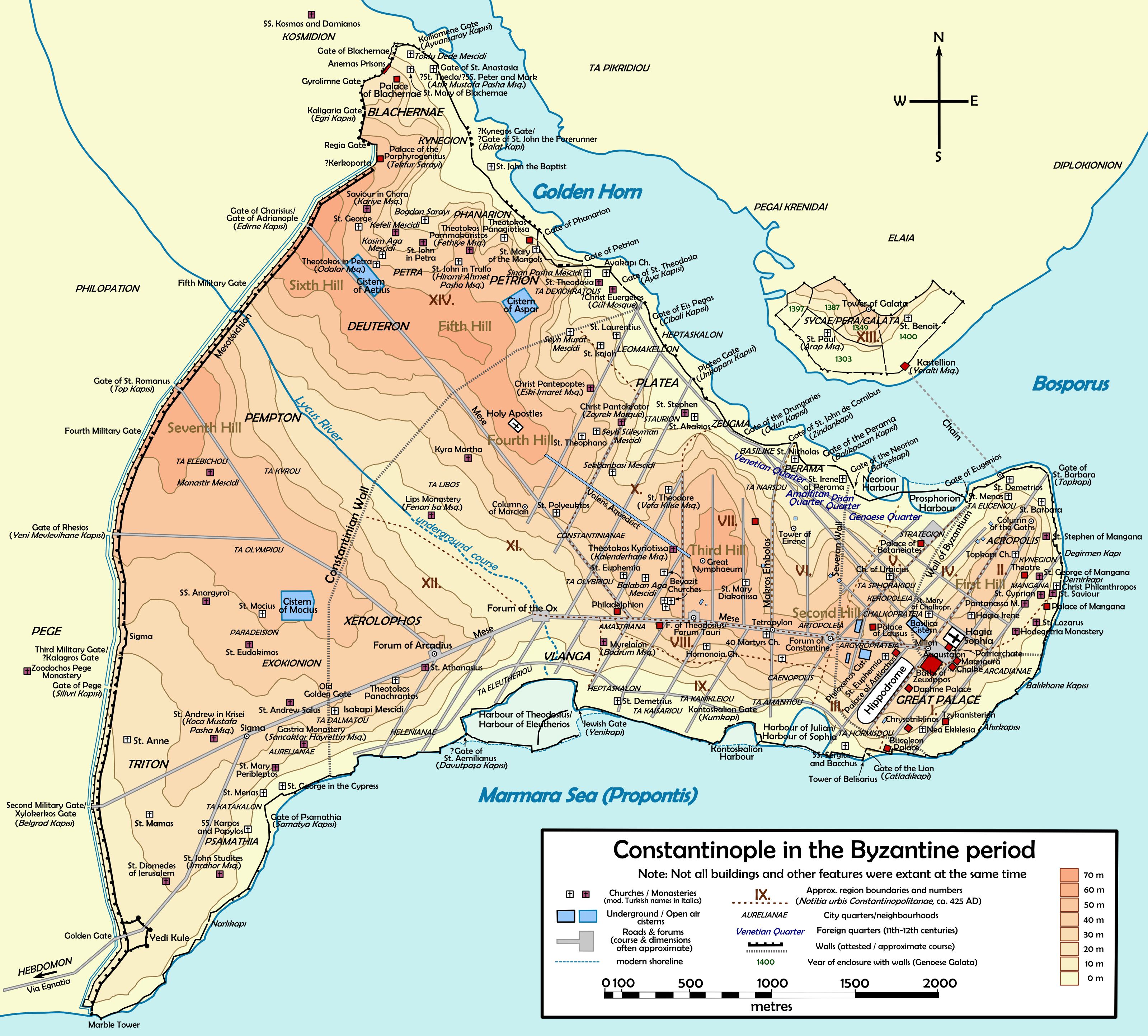
la, Constantinopolis ota, قسطنطينيه , alternate_name = Byzantion (earlier Greek name), Nova Roma ("New Rome"), Miklagard/Miklagarth (Old Norse), Tsargrad ( Slavic), Qustantiniya (Arabic), Basileuousa ("Queen of Cities"), Megalopolis ("the Great City"), Πόλις ("the City"), Kostantiniyye or Konstantinopolis ( Turkish) , image = Byzantine Constantinople-en.png , alt = , caption = Map of Constantinople in the Byzantine period, corresponding to the modern-day Fatih district of Istanbul , map_type = Istanbul#Turkey Marmara#Turkey , map_alt = A map of Byzantine Istanbul. , map_size = 275 , map_caption = Constantinople was founded on the former site of the Greek colony of Byzantion, which today is known as Istanbul in Turkey. , coordinates = , location = Fatih, İstanbul, Turkey , region = Marmara Region , type = Imperial city , part_of = , length = , width ... [...More Info...] [...Related Items...] OR: [Wikipedia] [Google] [Baidu] |
Taksim Square
Taksim Square ( tr, Taksim Meydanı, ), situated in Beyoğlu in the European part of Istanbul, Turkey, is a major tourist and leisure district famed for its restaurants, shops, and hotels. It is considered the heart of modern Istanbul, with the central station of the Istanbul Metro network. Taksim Square is also the location of the Republic Monument ( tr, Cumhuriyet Anıtı) which was crafted by Pietro Canonica and inaugurated in 1928. The monument commemorates the 5th anniversary of the foundation of the Republic of Turkey in 1923, following the Turkish War of Independence. The square is flanked to the south by The Marmara Hotel, to the east by the Atatürk Cultural Center, Atatürk Cultural Centre, to the north by Taksim Gezi Park, Gezi Park and to the west by Taksim Mosque. Several major roads converge on the square: Gümüşsuyu Caddesi, Cumhuriyet Caddesi, Tarlabaşı Bulvarı, İstiklal Avenue, İstiklal Caddesi and Sıraselviler Caddesi. History The word Taksim means "di ... [...More Info...] [...Related Items...] OR: [Wikipedia] [Google] [Baidu] |
Eminönü
Eminönü is a predominantly commercial waterfront area of Istanbul within the Fatih district near the confluence of the Golden Horn with the southern entrance of the Bosphorus strait and the Sea of Marmara. It is connected to Karaköy (historic Galata) via the Galata Bridge across the Golden Horn. It was administered as part of the Sultanahmet district from 1928 to 2009 when Sultanahmet was absorbed into Fatih. Eminönü's busy main square is overlooked by the New Mosque (Yeni Cami in Turkish) and the Spice Bazaar (Mısır Çarşısı in Turkish). Eminönü is an important transport hub. Several ferries have terminals along the Eminönü waterfront and the T1 tram has a stop here. To the southeast Eminönü runs into Sirkeci, while to the northwest it merges with the shopping areas of Tahtakale and Küçükpazar. Inland from Emiõnü is another shopping district, Mahmutpaşa. In Turkish, Eminönü means 'in front of justice' ('emin' meaning 'justice' and 'önü' meaning ... [...More Info...] [...Related Items...] OR: [Wikipedia] [Google] [Baidu] |
Beyazıt Square
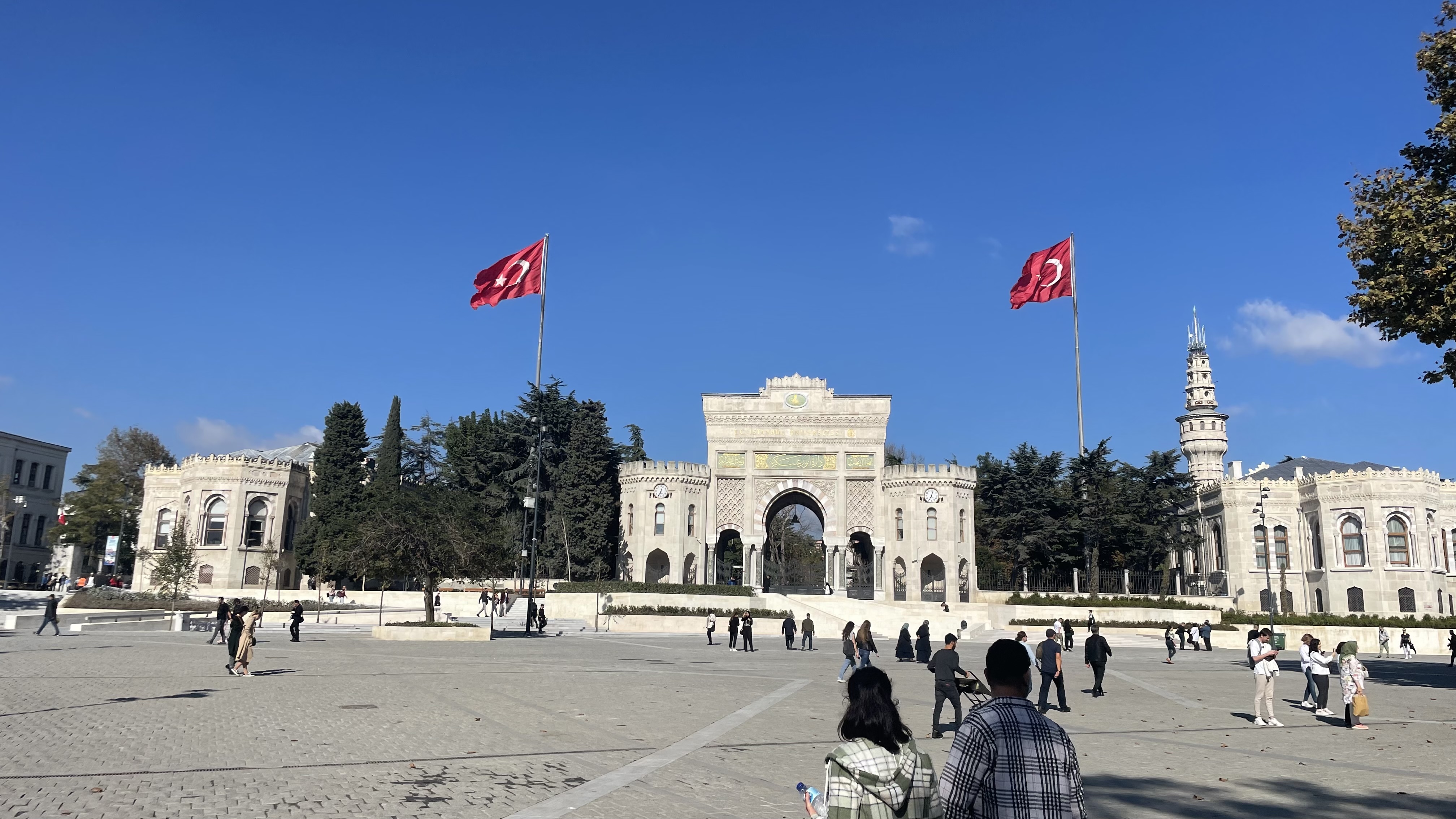
Beyazıt Square ( tr, Beyazıt Meydanı) lies to the north of Ordu Caddesi in the district of Fatih, Istanbul, Turkey. Officially named ''Freedom Square'' (), it is more generally known as Beyazıt Square after the early Ottoman Bayezid II Mosque on one side. The square is the former site of the Forum of Theodosius (AKA Forum Tauri) built by Constantine the Great. Its current form was designed by Turgut Cansever. Facing the mosque across the square is a medrese that formed part of its complex. In the past this served as a Museum of Calligraphy. After long years of closure, this was under restoration in 2022. On one side of the square is the main entrance to Istanbul University, its buildings designed by the French architect Marie-Auguste Antoine Bourgeois. It is accessible via a grand Neo-Renaissance arch. The Beyazıt Tower, once a fire-warning tower, in the grounds of the university is visible from the square. Between the entrance to the university and the mosque is the Bey ... [...More Info...] [...Related Items...] OR: [Wikipedia] [Google] [Baidu] |
Vezneciler (Istanbul Metro)
Vezneciler is a station on the M2 line of the Istanbul Metro. The station is located under Şehzadebaşı Street and 16 Mart Şehitleri Street in the historical Fatih district of Istanbul. Opened on 16 March 2014, Vezneciler is the most recently opened station on the M2 line. During the inauguration the station was dedicated to Ottoman police officers who were killed during a conflict with British forces during the Occupation of Constantinople in 1920. Istanbul University's main campus, Beyazıt Square and the Şehzade Mosque The Şehzade Mosque ( tr, Şehzade Camii, from the original Persian شاهزاده ''Šāhzādeh'', meaning "prince") is a 16th-century Ottoman imperial mosque located in the district of Fatih, on the third hill of Istanbul, Turkey. It was comm ... are a few landmarks in the vicinity of the station. On 7 June 2016, a bomb reportedly targeting a police bus struck around this station. Layout References {{Istanbul Metro navbox Railway stations open ... [...More Info...] [...Related Items...] OR: [Wikipedia] [Google] [Baidu] |
List Of Sovereign States
The following is a list providing an overview of sovereign states around the world with information on their status and recognition of their sovereignty. The 206 listed states can be divided into three categories based on membership within the United Nations System: 193 UN member states, 2 UN General Assembly non-member observer states, and 11 other states. The ''sovereignty dispute'' column indicates states having undisputed sovereignty (188 states, of which there are 187 UN member states and 1 UN General Assembly non-member observer state), states having disputed sovereignty (16 states, of which there are 6 UN member states, 1 UN General Assembly non-member observer state, and 9 de facto states), and states having a special political status (2 states, both in free association with New Zealand). Compiling a list such as this can be a complicated and controversial process, as there is no definition that is binding on all the members of the community of nations concerni ... [...More Info...] [...Related Items...] OR: [Wikipedia] [Google] [Baidu] |
Golden Horn
The Golden Horn ( tr, Altın Boynuz or ''Haliç''; grc, Χρυσόκερας, ''Chrysókeras''; la, Sinus Ceratinus) is a major urban waterway and the primary inlet of the Bosphorus in Istanbul, Turkey. As a natural estuary that connects with the Bosphorus Strait at the point where the strait meets the Sea of Marmara, the waters of the Golden Horn help define the northern boundary of the peninsula constituting "Old Istanbul" (ancient Byzantium and Constantinople), the tip of which is the promontory of Sarayburnu, or Seraglio Point. This estuarial inlet geographically separates the historic center of Istanbul from the rest of the city, and forms a horn-shaped, sheltered harbor that in the course of history has protected Greek, Roman, Byzantine, Ottoman and other maritime trade ships for thousandsBBC: "Istanbul's ... [...More Info...] [...Related Items...] OR: [Wikipedia] [Google] [Baidu] |


.jpg)


