|
Valley County, Idaho
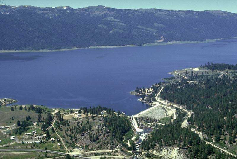
Valley County is a rural County (United States), county located in the U.S. state of Idaho. As of the 2020 United States Census, 2020 census, the population was 11,746. The county seat is Cascade, Idaho, Cascade, and the largest city is McCall, Idaho, McCall. Established in 1917, it was named after the Long Valley of the North Fork of the Payette River, which extends over from Payette Lake at McCall, Idaho, McCall south to Cascade, Idaho, Cascade to Round Valley. The valley was formerly a summer pasture for livestock from the Treasure Valley, Boise Valley. Since the completion of the Cascade Dam in 1948, much of the northern valley has been covered by the Lake Cascade, Cascade Reservoir. Valley County is home to the Idaho ground squirrel. History Packer John Welch, who had contracted to freight supplies to miners of Idaho City, established a camp on Gold Fork Creek and a brush cabin on Clear Creek in the 1860s. [...More Info...] [...Related Items...] OR: [Wikipedia] [Google] [Baidu] |
Cascade, Idaho
Cascade is a rural city in and the county seat of Valley County, Idaho, United States. The population was 939 at the 2010 census, down from 997 in 2000.Spokesman-Review - 2010 census - Cascade, Idaho - accessed 2011-12-26 History The Cascade Dam across the was completed in 1948, and is located in the north end of the city. The dam created Cascade Reservoir along the west side of the city. With the introduction of nearby in 2004, the name was officially changed to |
Idaho County, Idaho
Idaho County is a county in the U.S. state of Idaho, and the largest by area in the state. As of the 2020 census, the population was 16,541. The county seat is Grangeville. Previous county seats of the area were Florence (1864–68), Washington (1868–75), and Mount Idaho (1875–1902). History Idaho County's oldest non-native settlements are ghost towns. Discovery of gold occurred in succession at Elk City, Newsome, and Florence during the spring and summer of 1861. At the time, all of the settlements were within Shoshone County, Washington Territory. Thousands flocked to Florence. As a result, Idaho County was founded as a region of Washington Territory in 1861, named for a steamer called ''Idaho'' that was launched on the Columbia River in 1860. It was reorganized by the Idaho Territorial Legislature on February 4, 1864. In this context, the Idaho Territory and the State of Idaho are both preceded by the county name. Settlements at Cottonwood, Mount Idaho, and Warre ... [...More Info...] [...Related Items...] OR: [Wikipedia] [Google] [Baidu] |
Ada County, Idaho
Ada County is located in the southwestern part of Idaho, United States. As of the 2021 United States census estimate, the county had a population of 511,931, making it by far the state's most populous county; it is home to 26.8% of the state's population. The county seat and largest city is Boise, which is also the state capital. Ada County is included in the Boise metropolitan area. The Ada County Highway District has jurisdiction over all the local county and city streets, except for private roads and state roads. In the interior Pacific Northwest east of the Cascade Range, Ada County ranks second in population, behind Spokane County, Washington. History Ada County was created by the Idaho Territory legislature on December 22, 1864, partitioned from Boise County. It is named for Ada Riggs, the daughter of H.C. Riggs, a member of the legislature; he established the county and was a co-founder of Boise. Canyon County, which originally included Payette County and most of Ge ... [...More Info...] [...Related Items...] OR: [Wikipedia] [Google] [Baidu] |
Eagle, Idaho
Eagle is a city in Ada County, Idaho, 10 miles northwest of Boise. The population was 30,346 at the time of the 2020 census. Geography According to the United States Census Bureau, the city has a total area of , of which is land and is water. Climate This region experiences warm to hot, dry summers, and cold, dry winters averaging 10 inches of snow, with summer high temperatures averaging 85 °F and winter low temperatures averaging 25.6 °F. According to the Köppen climate classification system, Eagle has a "Csb" on climate maps. Demographics 2020 census At the 2020 census there were 30,346 people, 10,610 households, and 8,293 families living in the city. The population density was . There were 11,964 housing units at an average density of . The racial makeup of the city was 91.1% White, 0.4% African American, 0.5% Native American, 1.8% Asian, 0.2% Pacific Islander, 1.8% from other races, and 4.9% from two or more races. Hispanic or Latino of any race were 7.6 ... [...More Info...] [...Related Items...] OR: [Wikipedia] [Google] [Baidu] |
National Scenic Byway
A National Scenic Byway is a road recognized by the United States Department of Transportation for one or more of six "intrinsic qualities": archeological, cultural, historic, natural, recreational, and scenic. The program was established by Congress in 1991 to preserve and protect the nation's scenic but often less-traveled roads and promote tourism and economic development. The National Scenic Byways Program (NSBP) is administered by the Federal Highway Administration (FHWA). The most scenic byways are designated All-American Roads, which must meet two out of the six intrinsic qualities. The designation means they have features that do not exist elsewhere in the United States and are unique and important enough to be tourist destinations unto themselves. As of January 21, 2021, there are 184 National Scenic Byways located in 48 states (all except Hawaii and Texas). History The NSBP was established under the Intermodal Surface Transportation Efficiency Act of 1991, w ... [...More Info...] [...Related Items...] OR: [Wikipedia] [Google] [Baidu] |
Idaho State Highway 55
State Highway 55 (SH-55) is an Idaho highway from Marsing to New Meadows, connecting with US-95 at both ends. From Marsing it travels east to Nampa, Meridian, and Eagle, then north to Horseshoe Bend. SH-55 then climbs the Payette River to Banks, then its north fork to the Long Valley, through the towns of Cascade and McCall. After descending a narrow canyon to Meadows, SH-55 terminates in New Meadows at the junction with US-95. Route description In the southwest corner of Idaho, State Highway 55 starts at the junction with US-95, approximately west of Marsing. The highway heads eastward as it travels through Marsing, crosses the Snake River and the Snake River Valley AVA. The highway continues east to Nampa (mostly as Karcher Road), where it meets Interstate 84 and The highway is cosigned with those routes as it heads eastward to Meridian. SH-55 turns northward at Eagle Road and crosses the Boise River near Eagle. The junction with SH-44 is in Eagle, where the ... [...More Info...] [...Related Items...] OR: [Wikipedia] [Google] [Baidu] |
Payette National Forest
The Payette National Forest is a U.S. National Forest located in central western Idaho, in parts of Valley, Idaho, Adams, and Washington counties. The land area consists of approximately 2.3 million acres (9,300 km2) of federally managed lands. It is bordered by Hells Canyon National Recreation Area and the Hells Canyon to the west, Salmon-Challis National Forest to the east, Boise National Forest to the south, and the Nez Perce National Forest to the north. The Payette National Forest is a part of the Intermountain Region (Region 4). It is under the jurisdiction of a forest supervisor in McCall and is divided into five ranger districts: McCall, Krassel, New Meadows, Council, and Weiser. The Payette also provides the largest component of the Frank Church-River of No Return Wilderness, the second-largest designated wilderness area outside Alaska. Approximately of it is within the wilderness, comprising one-third of its total acreage. ( Five other National Forests als ... [...More Info...] [...Related Items...] OR: [Wikipedia] [Google] [Baidu] |
Boise National Forest
Boise National Forest is a National Forest covering of the U.S. state of Idaho. Created on July 1, 1908, from part of Sawtooth National Forest, it is managed by the U.S. Forest Service as five units: the Cascade, Emmett, Idaho City, Lowman, and Mountain Home ranger districts. The Idaho Batholith underlies most of Boise National Forest, forming the forest's Boise, Salmon River, and West mountain ranges; the forest reaches a maximum elevation of on Steel Mountain. Common land cover includes sagebrush steppe and spruce-fir forests; there are of streams and rivers and of lakes and reservoirs. Boise National Forest contains 75 percent of the known populations of Sacajawea's bitterroot, a flowering plant endemic to Idaho. The Shoshone people occupied the forest before European settlers arrived in the early 19th century. Many of the early settlers were trappers and prospectors before gold was discovered in 1862. After the 1860s Boise Basin gold rush ended, mining of ... [...More Info...] [...Related Items...] OR: [Wikipedia] [Google] [Baidu] |
Lemhi County, Idaho
Lemhi County is a county located in the U.S. state of Idaho. As of the 2020 census, the population was 7,974. The largest city and county seat is Salmon. The county was established in 1869, named after Fort Lemhi (or Limhi), a remote Mormon missionary settlement from 1855 to 1858 in Bannock and Shoshone territory. Traffic signals *Main (Hwy 28) and Challis (Hwy 93), Salmon *Main (Hwy 93) and Church, Salmon Geography According to the U.S. Census Bureau, the county has a total area of , of which is land and (0.1%) is water. It is the fourth-largest county in Idaho by area. The highest point is Bell Mountain at above sea level, and the lowest point is the Salmon River as it exits on the county's western border with Idaho County at approximately . The river cuts through the center of Lemhi County before turning west. The county's eastern border with Beaverhead County, Montana, is the Continental Divide. Adjacent counties *Idaho County, Idaho – northwest/Pacific Time border ... [...More Info...] [...Related Items...] OR: [Wikipedia] [Google] [Baidu] |
Custer County, Idaho
Custer County is a rural mountain county in the center of the U.S. state of Idaho. As of the 2020 census, the population was 4,275. The county seat is Challis. Established in 1881, the county was named for the General Custer Mine, where gold was discovered five years earlier. Custer County relies on ranching, mining, and tourism as its main resources. Geography According to the U.S. Census Bureau, the county has a total area of , of which is land and (0.3%) is water. It is the third-largest county in Idaho by area. The Lost River Range, the state's highest mountains, are located in eastern Custer County. The highest is Borah Peak, the highest natural point in Idaho at . On the western border of the county is Idaho's famous Sawtooth Range; the tallest is Thompson Peak in Custer County, above picturesque Redfish Lake. Twenty miles (32 km) east are the White Cloud Mountains, the tallest of which is Castle Peak at . The Salmon River and Big Lost River flow through C ... [...More Info...] [...Related Items...] OR: [Wikipedia] [Google] [Baidu] |


