|
Vértes Hills
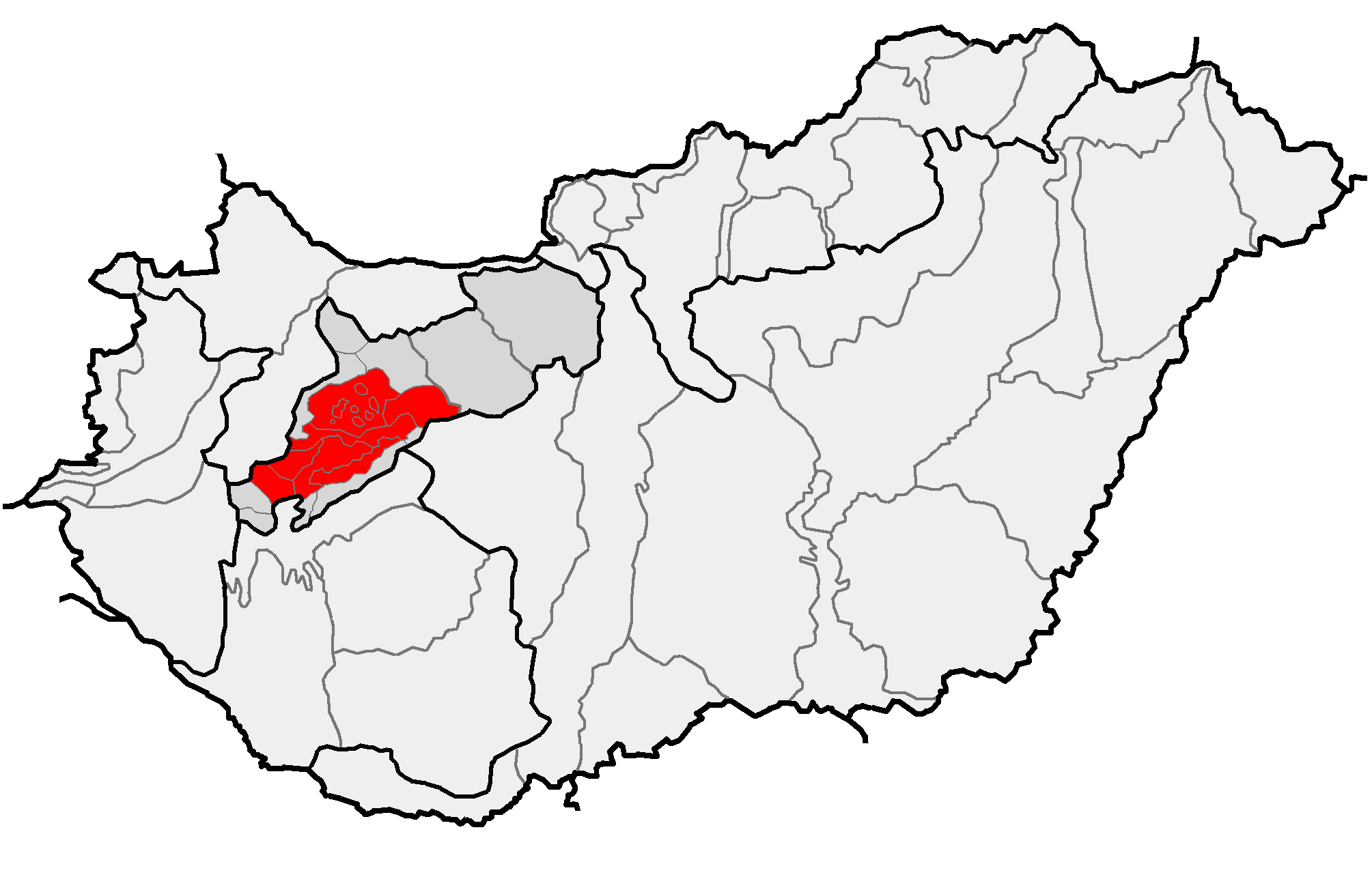
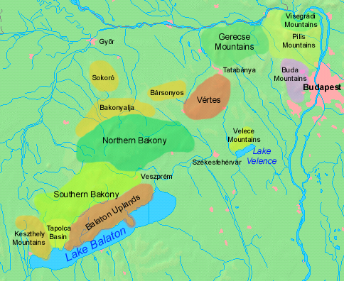
Vértes is a mountain range in north-western Hungary, in the Central Transdanubian region, between the ranges Bakony and Gerecse. The Vértes Mountains are part of the Transdanubian Mountains. Geography The area of the Vértes occupies . It is about 30 km long and 10–15 km wide. The average altitude is above sea level is 350 meters; its highest points are 487 m (Nagy-Csákány), 480 m (Körtvélyes) and 479 m (Csóka-hegy). Geologically the Vértes constitute a fairly uniform structure. On the surface of the entire mountain there are no older rocks than those of the mid-Triassic. The main rock is dolomite—CaMg(CO3)2—from the upper Triassic. All the layers are ancient marine deposits. The Vértes possesses a well-developed valley network (1260 km), but in spite of this spring and rivers are very rare in the mountain. Yearly sunshine duration is around 1950–2000 hours. The average annual temperature above the height of 350 meters i ... [...More Info...] [...Related Items...] OR: [Wikipedia] [Google] [Baidu] |
Hungary
Hungary ( hu, Magyarország ) is a landlocked country in Central Europe. Spanning of the Carpathian Basin, it is bordered by Slovakia to the north, Ukraine to the northeast, Romania to the east and southeast, Serbia to the south, Croatia and Slovenia to the southwest, and Austria to the west. Hungary has a population of nearly 9 million, mostly ethnic Hungarians and a significant Romani minority. Hungarian, the official language, is the world's most widely spoken Uralic language and among the few non-Indo-European languages widely spoken in Europe. Budapest is the country's capital and largest city; other major urban areas include Debrecen, Szeged, Miskolc, Pécs, and Győr. The territory of present-day Hungary has for centuries been a crossroads for various peoples, including Celts, Romans, Germanic tribes, Huns, West Slavs and the Avars. The foundation of the Hungarian state was established in the late 9th century AD with the conquest of the Carpathian Basin by Hungar ... [...More Info...] [...Related Items...] OR: [Wikipedia] [Google] [Baidu] |
Fejér County
Fejér ( hu, Fejér megye, ) is an administrative county (comitatus or megye) in Central Hungary. It lies on the west bank of the river Danube and nearly touches the eastern shore of Lake Balaton. It shares borders with the Hungarian counties Veszprém, Komárom-Esztergom, Pest, Bács-Kiskun, Tolna and Somogy. The capital of Fejér county is Székesfehérvár. Geography Geographically, Fejér County is very diverse; its southern part is similar (and adjacent) to the Great Hungarian Plain, and other parts are hilly (Bakony, Vértes, Gerecse mountains). Lake Velence, a popular resort, is also located there. History Early history The area was already inhabited 20,000 years ago. When this part of Hungary formed a Roman province called ''Pannonia'', several settlements stood here: the capital was Gorsium, but there were other significant towns too, where present-day Baracs and Dunaújváros are (the towns were called ''Annamatia'' and ''Intercisa'', respectively). In the earl ... [...More Info...] [...Related Items...] OR: [Wikipedia] [Google] [Baidu] |
Komárom-Esztergom County
Komárom-Esztergom ( hu, Komárom-Esztergom megye, ; german: Komitat Komorn-Gran; sk, Komárňansko-ostrihomská župa) is an administrative Hungarian county in Central Transdanubia Region; its shares its northern border the Danube with Slovakia. It shares borders with the Hungarian counties of , , and and the Slovakian Nitra Region (Nové Zámky District, Komárno District). Its county seat is Tatabánya. History Middle Ages The predecessor of Komárom Esztergom County, Komárom county and Esztergom county were founded by Stephen I of Hungary. Both counties had parts that now belong to Slovakia. Throughout their history the borders of the two counties were frequently modified, and they were merged several times as well. When the castle of Esztergom was captured by the Ottomans in 1543, the leadership of the county fled from there. The castles of Érsekújvár, Komárom, and Tata were the three border castles stopping the Ottoman conquest for long decades. During the O ... [...More Info...] [...Related Items...] OR: [Wikipedia] [Google] [Baidu] |
Dolomite (rock)
Dolomite (also known as dolomite rock, dolostone or dolomitic rock) is a sedimentary carbonate rock that contains a high percentage of the mineral dolomite, CaMg(CO3)2. It occurs widely, often in association with limestone and evaporites, though it is less abundant than limestone and rare in Cenozoic rock beds (beds less than about 66 million years in age). The first geologist to distinguish dolomite rock from limestone was Belsazar Hacquet in 1778. Most dolomite was formed as a magnesium replacement of limestone or of lime mud before lithification. The geological process of conversion of calcite to dolomite is known as dolomitization and any intermediate product is known as dolomitic limestone. The "dolomite problem" refers to the vast worldwide depositions of dolomite in the past geologic record in contrast to the limited amounts of dolomite formed in modern times. Recent research has revealed sulfate-reducing bacteria living in anoxic conditions precipitate dolomite which ind ... [...More Info...] [...Related Items...] OR: [Wikipedia] [Google] [Baidu] |
Transdanubian Mountains
__NOTOC__ The Transdanubian Mountains (sometimes also referred to as ''Bakony Forest, Dunántúl Highlands, Highlands of Dunántúl, Highlands of Transdanubia, Mountains of Dunántúl, Mountains of Transdanubia, Transdanubian Central Range, Transdanubian Hills, Transdanubian Midmountains'' or ''Transdanubian Mid-Mountains'', ) are a mountain range in Hungary covering about 7000 km2. Its highest peak is the ''Pilis'', with a height of . Parts of the mountains *Bakony ** ''Southern Bakony'' ** ''Northern Bakony'' *** Keszthely Plateau *** Tapolca Basin *** Balaton Uplands **** Bakonyalja **** Sokoró Hills *Vértes Mountains ** Vértesalja (Bársonyos) *Velence Hills * Dunazug Mountains **Gerecse Mountains **Buda Hills ** Pilis Mountains Visegrád Mountains are often considered a part of it for geopolitical reasons, but geographically they are part of the North Hungarian Mountains. Gallery File:Gulács01.jpg File:Pliocene Volcanoes near Lake Balaton in Hungary.jpg File: ... [...More Info...] [...Related Items...] OR: [Wikipedia] [Google] [Baidu] |
Mountain Range
A mountain range or hill range is a series of mountains or hills arranged in a line and connected by high ground. A mountain system or mountain belt is a group of mountain ranges with similarity in form, structure, and alignment that have arisen from the same cause, usually an orogeny. Mountain ranges are formed by a variety of geological processes, but most of the significant ones on Earth are the result of plate tectonics. Mountain ranges are also found on many planetary mass objects in the Solar System and are likely a feature of most terrestrial planets. Mountain ranges are usually segmented by highlands or mountain passes and valleys. Individual mountains within the same mountain range do not necessarily have the same geologic structure or petrology. They may be a mix of different orogenic expressions and terranes, for example thrust sheets, uplifted blocks, fold mountains, and volcanic landforms resulting in a variety of rock types. Major ranges Most geolo ... [...More Info...] [...Related Items...] OR: [Wikipedia] [Google] [Baidu] |
Bakony
Bakony () is a mountainous region in Transdanubia, Hungary. It forms the largest part of the Transdanubian Mountains. It is located north of Lake Balaton and lies almost entirely in Veszprém county. The Bakony is divided into the Northern and Southern Bakony through the Várpalota-Veszprém-Ajka-Devecser line. (706 m) high Kőris-hegy in the Northern Bakony is the highest peak of the range. Other high mountains are Som-hegy (649 m), Középső-Hajag (646 m), Öreg-Futóné (576 m) in the Northern Bakony, and Kab-hegy (599 m), Üsti-hegy (536 m) and Agár-tető (511 m) in Southern Bakony. Zirc is often called the ''Capital of the Bakony'' because it is located in the center of the Northern Bakony. The Bakony Museum Zirc (german: Sirtz) is a town in Veszprém county, Hungary. It is the administrative seat of Zirc District. At the end of the 19th century and the beginning of the 20th century, Jews lived in Zirc. In 1910, 92 Jews lived in Zirc, Some of them ... is loca ... [...More Info...] [...Related Items...] OR: [Wikipedia] [Google] [Baidu] |
Gerecse Mountains
Gerecse is a mountain range in north-western Hungary, that belongs to the Transdanubian Mountains Geography The range lies in the Central Transdanubian region and connects Vértes Hills with Pilis Mountains in Komárom-Esztergom County, between the town of Tatabánya and the Danube River. Gerecse occupies an area of 850 km2 (20,300 ha). The highest point is ''Nagy-Gerecse'' at 634 m. The main rock is limestone and chalk. Biology Deciduous oak forests cover the lower slopes, with submontane species of Quercus, Carpinus, Fagus, and at higher altitudes karst scrub. The area is 70% forest, 5% scrubland, 10% grassland, and 15% artificial landscapes. Yearly sunshine duration is around 1,980 hours. The average annual temperature above the height of 350 meters is 9.5 C (in January -2,8 C). The average annual precipitation is 640 millimeters. Gallery Image:Farkasvölgy.jpg, Farkasvölgy (Wolf-valley) Image:Forest in Gerecse Mountains.jpg, Forest in the Gerecse Image:Pusztam ... [...More Info...] [...Related Items...] OR: [Wikipedia] [Google] [Baidu] |
Henry III, Holy Roman Emperor
Henry III (28 October 1016 – 5 October 1056), called the Black or the Pious, was Holy Roman Emperor from 1046 until his death in 1056. A member of the Salian dynasty, he was the eldest son of Conrad II and Gisela of Swabia. Henry was raised by his father, who made him Duke of Bavaria in 1026, appointed him co-ruler in 1028 and bestowed him with the duchy of Swabia and the Kingdom of Burgundy ten years later in 1038. The emperor's death the following year ended a remarkably smooth and harmonious transition process towards Henry's sovereign rule, that was rather uncharacteristic for the Ottonian and Salian monarchs. Henry succeeded Conrad II as Duke of Carinthia and King of Italy and continued to pursue his father's political course on the basis of ''virtus et probitas'' (courage and honesty), which led to an unprecedented sacral exaltation of the kingship. In 1046 Henry ended the papal schism, was crowned Emperor by Pope Clement II, freed the Vatican from dependence on the Roma ... [...More Info...] [...Related Items...] OR: [Wikipedia] [Google] [Baidu] |
Gánt
Gánt is a village in Fejér county, Hungary Hungary ( hu, Magyarország ) is a landlocked country in Central Europe. Spanning of the Carpathian Basin, it is bordered by Slovakia to the north, Ukraine to the northeast, Romania to the east and southeast, Serbia to the south, Croatia a .... External links * Street map Populated places in Fejér County {{Fejer-geo-stub ... [...More Info...] [...Related Items...] OR: [Wikipedia] [Google] [Baidu] |
Bauxite
Bauxite is a sedimentary rock with a relatively high aluminium content. It is the world's main source of aluminium and gallium. Bauxite consists mostly of the aluminium minerals gibbsite (Al(OH)3), boehmite (γ-AlO(OH)) and diaspore (α-AlO(OH)), mixed with the two iron oxides goethite (FeO(OH)) and haematite (Fe2O3), the aluminium clay mineral kaolinite (Al2Si2O5(OH)4) and small amounts of anatase (TiO2) and ilmenite (FeTiO3 or FeO.TiO2). Bauxite appears dull in luster and is reddish-brown, white, or tan. In 1821, the French geologist Pierre Berthier discovered bauxite near the village of Les Baux in Provence, southern France. Formation Numerous classification schemes have been proposed for bauxite but, , there was no consensus. Vadász (1951) distinguished lateritic bauxites (silicate bauxites) from karst bauxite ores (carbonate bauxites): * The carbonate bauxites occur predominantly in Europe, Guyana, Suriname, and Jamaica above carbonate rocks (limestone and do ... [...More Info...] [...Related Items...] OR: [Wikipedia] [Google] [Baidu] |


