|
Vostok (sloop-of-war)
''Vostok'' was a 28-gun sloop-of-war of the Imperial Russian Navy, the lead ship of the First Russian Antarctic Expedition in 1819–1821, during which Fabian Gottlieb von Bellingshausen (commander of the ship) and Mikhail Lazarev (commanding '' Mirny'', the second ship) circumnavigated the globe, discovered the continent of Antarctica and twice circumnavigated it, and discovered a number of islands and archipelagos in the Southern Ocean and the Pacific.Шлюп "Восток" (''tr. "Sloop "Vostok""'') at sailhistory.ru History  ''Vostok'' was launched in 1 ...
[...More Info...] [...Related Items...] OR: [Wikipedia] [Google] [Baidu] |
Fabian Gottlieb Von Bellingshausen
Fabian Gottlieb Thaddeus von Bellingshausen (russian: Фадде́й Фадде́евич Беллинсга́узен, translit=Faddéy Faddéevich Bellinsgáuzen; – ) was a Russian naval officer, cartographer and explorer, who ultimately rose to the rank of admiral. He participated in the first Russian circumnavigation of the globe, and subsequently became a leader of another circumnavigation expedition that discovered the continent of Antarctica. Like Otto von Kotzebue and Adam Johann von Krusenstern, Bellingshausen belonged to the cohort of prominent Baltic German navigators who helped Russia launch its naval expeditions. Bellingshausen was born on Osel Island. He started his service in the Russian Baltic Fleet, and after distinguishing himself joined the first Russian circumnavigation of the Earth in 1803–1806, serving on the merchant ship ''Nadezhda'' under the captaincy of Adam Johann von Krusenstern. After the journey, he published a collection of maps of the ... [...More Info...] [...Related Items...] OR: [Wikipedia] [Google] [Baidu] |
Commander
Commander (commonly abbreviated as Cmdr.) is a common naval officer rank. Commander is also used as a rank or title in other formal organizations, including several police forces. In several countries this naval rank is termed frigate captain. Commander is also a generic term for an officer commanding any armed forces unit, for example "platoon commander", "brigade commander" and "squadron commander". In the police, terms such as "borough commander" and "incident commander" are used. Commander as a naval and air force rank Commander is a rank used in navies but is very rarely used as a rank in armies. The title, originally "master and commander", originated in the 18th century to describe naval officers who commanded ships of war too large to be commanded by a lieutenant but too small to warrant the assignment of a post-captain and (before about 1770) a sailing master; the commanding officer served as his own master. In practice, these were usually unrated sloops-of-war of no ... [...More Info...] [...Related Items...] OR: [Wikipedia] [Google] [Baidu] |
List Of Geological Features On Mercury
List of geological features on Mercury is an itemization of mountains, valleys, craters and other landform features of the planet Mercury. Different types of features are named after different things: Mercurian ridges are called dorsa, and are named after astronomers who made detailed studies of the planet; valleys are called valles, and are named after ancient abandoned cities, towns, and settlements; crater chains are called catenae and are named after radio telescope facilities; plains are called planitiae, and most are named after mythological names associated with Mercury; escarpments are called rupes and are named after the ships of famous explorers; long, narrow depressions are called fossae and are named after works of architecture; bright spots are called faculae and are named after the word snake in various languages. See also list of craters on Mercury, list of albedo features on Mercury, and list of quadrangles on Mercury Longitude is west longitude. List of geologi ... [...More Info...] [...Related Items...] OR: [Wikipedia] [Google] [Baidu] |
Geographic Names Information System
The Geographic Names Information System (GNIS) is a database of name and locative information about more than two million physical and cultural features throughout the United States and its territories, Antarctica, and the associated states of the Marshall Islands, Federated States of Micronesia, and Palau. It is a type of gazetteer. It was developed by the United States Geological Survey (USGS) in cooperation with the United States Board on Geographic Names (BGN) to promote the standardization of feature names. Data were collected in two phases. Although a third phase was considered, which would have handled name changes where local usages differed from maps, it was never begun. The database is part of a system that includes topographic map names and bibliographic references. The names of books and historic maps that confirm the feature or place name are cited. Variant names, alternatives to official federal names for a feature, are also recorded. Each feature receives a per ... [...More Info...] [...Related Items...] OR: [Wikipedia] [Google] [Baidu] |
Alexander Island
Alexander Island, which is also known as Alexander I Island, Alexander I Land, Alexander Land, Alexander I Archipelago, and Zemlja Alexandra I, is the largest island of Antarctica. It lies in the Bellingshausen Sea west of Palmer Land, Antarctic Peninsula from which it is separated by Marguerite Bay and George VI Sound. The George VI Ice Shelf entirely fills George VI Sound and connects Alexander Island to Palmer Land. The island partly surrounds Wilkins Sound, which lies to its west.Stewart, J. (2011) ''Antarctic An Encyclopedia'' McFarland & Company Inc, New York. 1776 pp. . Alexander Island is about long in a north–south direction, wide in the north, and wide in the south. Alexander Island is the second-largest uninhabited island in the world, after Devon Island. History Alexander Island was discovered on January 28, 1821, by a Russian expedition under Fabian Gottlieb von Bellingshausen, who named it Alexander I Land for the reigning Tsar Alexander I of Russia. Wha ... [...More Info...] [...Related Items...] OR: [Wikipedia] [Google] [Baidu] |
Havre Mountains
The Havre Mountains () are a large group of mountains forming the northwestern extremity of Alexander Island, Antarctica, extending in an east–west direction between Cape Vostok and the Russian Gap. They were first seen in 1821 by a Russian expedition under Fabian Gottlieb von Bellingshausen and re-sighted by the Belgian Antarctic Expedition, 1897–99. They were roughly charted by the French Antarctic Expedition, 1908–10, under Jean-Baptiste Charcot, who named them for Le Havre, the French port from which the ''Pourquoi-Pas (1908), Pourquol Pas?'' sailed in 1908. The mountains were mapped in detail from air photos taken by the Ronne Antarctic Research Expedition, 1947–48, by D. Searle of the Falkland Islands Dependencies Survey in 1960. See also * Lassus Mountains * Rouen Mountains Further reading * United States. Defense Mapping Agency. Hydrographic Center, Sailing Directions for Antarctica: Includes Islands South of Latitude 60°', P 206 * Defense Mapping Agency 1992 ... [...More Info...] [...Related Items...] OR: [Wikipedia] [Google] [Baidu] |
Cape Vostok
Cape Vostok () is a rocky headland which forms the west extremity of the Havre Mountains and the northwest extremity of Alexander Island in Antarctica. It was discovered by the First Russian Antarctic Expedition in 1821, led by Fabian Gottlieb von Bellingshausen and Mikhail Lazarev. It was mapped in detail from aerial photos taken by the Ronne Antarctic Research Expedition in 1947–48, and later by Searle of the Falkland Islands Dependencies Survey in 1960. Nearby Balgari Nunatak was visited in 1988 by the First Bulgarian Antarctic Expedition and chosen as the site of a future Bulgarian base in Antarctica, which however was eventually set up on Livingston Island instead. The formation was named by the United Kingdom Antarctic Place-Names Committee for the sloop ''Vostok'', commanded by Bellingshausen. The name means "east", although the cape is located on the western point of the island. [...More Info...] [...Related Items...] OR: [Wikipedia] [Google] [Baidu] |
Polynesia
Polynesia () "many" and νῆσος () "island"), to, Polinisia; mi, Porinihia; haw, Polenekia; fj, Polinisia; sm, Polenisia; rar, Porinetia; ty, Pōrīnetia; tvl, Polenisia; tkl, Polenihia (, ) is a subregion of Oceania, made up of more than 1,000 islands scattered over the central and southern Pacific Ocean. The indigenous people who inhabit the islands of Polynesia are called Polynesians. They have many things in common, including language relatedness, cultural practices, and traditional beliefs. In centuries past, they had a strong shared tradition of sailing and using stars to navigate at night. The largest country in Polynesia is New Zealand. The term was first used in 1756 by the French writer Charles de Brosses, who originally applied it to all the islands of the Pacific. In 1831, Jules Dumont d'Urville proposed a narrower definition during a lecture at the Geographical Society of Paris. By tradition, the islands located in the southern Pacific have also ... [...More Info...] [...Related Items...] OR: [Wikipedia] [Google] [Baidu] |
Line Islands
The Line Islands, Teraina Islands or Equatorial Islands (in Gilbertese, ''Aono Raina'') are a chain of 11 atolls (with partly or fully enclosed lagoons) and coral islands (with a surrounding reef) in the central Pacific Ocean, south of the Hawaiian Islands. The island chain stretches northwest to southeast across , making it one of the longest island chains in the world. It lies at the geographic center of the Pacific Ocean (), near Starbuck Island. One of the atolls in the group, Kiritimati, has the largest land area of any atoll in the world. Of the 11 atolls, all of which were formed by volcanic activity, only the Kiritimati and Tabuaeran atolls and Teraina island have a permanent population (one of the reefs, Filippo Reef, is shown on some maps, but its existence is doubted). Eight of the atolls are parts of Kiribati. The remaining three—Jarvis Island, Kingman Reef (which is largely submerged), and Palmyra Atoll—are territories of the United States grouped with the United ... [...More Info...] [...Related Items...] OR: [Wikipedia] [Google] [Baidu] |
Vostok Island
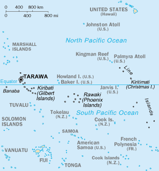
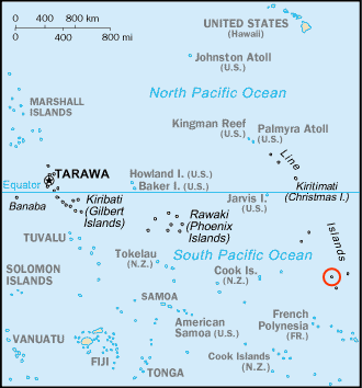
Vostok Island is an uninhabited coral island in the central Pacific Ocean, part of the Line Islands belonging to Kiribati. Other names for the island include Anne Island, Bostock Island, Leavitts Island, Reaper Island, Wostock Island or Wostok Island. The island was first sighted in 1820 by the Russian explorer Fabian Gottlieb von Bellingshausen, who named the island for his ship ''Vostok.'' Geography, flora and fauna Vostok covers a land area of . Its nearest neighbors are Flint Island, south-southeast; Caroline Atoll, to the east; and Penrhyn atoll, Penrhyn, to the west. It is in length, and is triangular-shaped. Beaches on the island range between wide, composed of coral sand and rubble. There is no lagoon or fresh water on the island, and no known freshwater lens. Vostok's major portion is covered with a pure stand of ''Pisonia grandis, Pisonia'' trees rooted in moist peat soil one meter thick. These trees, with heights of up to , grow so densely that no other plan ... [...More Info...] [...Related Items...] OR: [Wikipedia] [Google] [Baidu] |
Russian Admiralty
Board of Admiralties (russian: Адмиралтейств-коллегия, ''Admiralteystv-kollegiya'') was a supreme body for the administration of the Imperial Russian Navy and admiralty shipyards in the Russian Empire, established by Peter the Great on December 12, 1718, and headquartered in the Admiralty building, Saint Petersburg. It included several other admiralties of the Imperial Russia among which is the Nikolaev Admiralty. History The responsibilities of the Admiralty Board had been changing throughout its history. It supervised the construction of military ships, ports, harbors, and canals and administered Admiralty Shipyard. The Admiralty Board was also in charge of naval armaments and equipment, preparation of naval officers etc. The first president of the Admiralty Board was Count Fyodor Apraksin. In 1720, the Admiralty Board published a collection of naval decrees called ''Книга - устав морской о всем, что касается доброму у ... [...More Info...] [...Related Items...] OR: [Wikipedia] [Google] [Baidu] |


