|
Vorontsov Cave
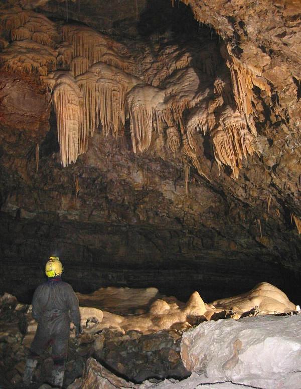
The Vorontsovskaya Cave System (Воронцовская система пещер) is a long chain of caves in the Khosta and Adler districts of Sochi, Russia. It is part of a range of Mesozoic limestones that runs parallel to the Black Sea coast for 400 km. and contains the Voronya Cave, the world's deepest cave. The Vorontsovskaya Cave (Воронцовская пещера) was the first cave to be surveyed. It may be accessed through a dozen entrances dotting the slopes of the Kudepsta River valley, at heights ranging from 419 to 720 meters above sea level. The Prometheus Grotto, with a length of over 120 meters, is developed as a tourist destination. The cave takes its name from the nearest settlement, Vorontsovka. It is known to contain bones of cave bears and early humans. In the late 20th century, it was discovered that the Vorontsovskaya Cave is connected to the Labyrinth Cave, the Kabany Proval, and the Dolgaya Cave by a network of sumps, or siphons. Some cave ... [...More Info...] [...Related Items...] OR: [Wikipedia] [Google] [Baidu] |
Khosta District
Khostinsky City District (russian: Хостинский райо́н) is one of four city districts of the city of Sochi in Krasnodar Krai, Russia. The city district borders Maykopsky District of the Republic of Adygea in the northeast, Adlersky City District in the southeast, Tsentralny City District in the west, and Lazarevsky City District in the northwest. In the southwest, it is bordered by the Black Sea. Population: Geography The district is located on the slopes of the Western Caucasus, which descend to the Black Sea. The coast within the district runs from northwest to southeast. The majority of the population in the districts lives at or close to the seashore, in former settlements later turned microdistricts. The biggest of them are (northwest to southeast) Svetlana, Bytha, Iskra, Matsesta, Maly Akhun, Khosta, and Kudepsta. Svetlana is essentially a suburb of the center of Sochi, and Kudepsta is separated from Adlersky City District by the Kudepsta River. Further ... [...More Info...] [...Related Items...] OR: [Wikipedia] [Google] [Baidu] |
Caves Of Russia
A cave or cavern is a natural void in the ground, specifically a space large enough for a human to enter. Caves often form by the weathering of rock and often extend deep underground. The word ''cave'' can refer to smaller openings such as sea caves, rock shelters, and grottos, that extend a relatively short distance into the rock and they are called ''exogene'' caves. Caves which extend further underground than the opening is wide are called ''endogene'' caves. Speleology is the science of exploration and study of all aspects of caves and the cave environment. Visiting or exploring caves for recreation may be called ''caving'', ''potholing'', or ''spelunking''. Formation types The formation and development of caves is known as ''speleogenesis''; it can occur over the course of millions of years. Caves can range widely in size, and are formed by various geological processes. These may involve a combination of chemical processes, erosion by water, tectonic forces, microorganisms ... [...More Info...] [...Related Items...] OR: [Wikipedia] [Google] [Baidu] |
Russian Federation
Russia (, , ), or the Russian Federation, is a List of transcontinental countries, transcontinental country spanning Eastern Europe and North Asia, Northern Asia. It is the List of countries and dependencies by area, largest country in the world, with its internationally recognised territory covering , and encompassing one-eighth of Earth's inhabitable landmass. Russia extends across Time in Russia, eleven time zones and shares Borders of Russia, land boundaries with fourteen countries, more than List of countries and territories by land borders, any other country but China. It is the List of countries and dependencies by population, world's ninth-most populous country and List of European countries by population, Europe's most populous country, with a population of 146 million people. The country's capital and List of cities and towns in Russia by population, largest city is Moscow, the List of European cities by population within city limits, largest city entirely within E ... [...More Info...] [...Related Items...] OR: [Wikipedia] [Google] [Baidu] |
Krasnodar Krai
Krasnodar Krai (russian: Краснода́рский край, r=Krasnodarsky kray, p=krəsnɐˈdarskʲɪj kraj) is a federal subject of Russia (a krai), located in the North Caucasus region in Southern Russia and administratively a part of the Southern Federal District. Its administrative center is the city of Krasnodar. The third most populous federal subject, the krai had a population of 5,226,647 as of the 2010 Census. Krasnodar Krai is formally and informally referred to as Kuban (russian: Кубань), a term denoting the historical region of Kuban situated between the Sea of Azov and the Kuban River which is mostly composed of the krai's territory. It is bordered by Rostov Oblast to the north, Stavropol Krai to the east, Karachay-Cherkessia to the south-east, and Adygea is an enclave entirely within the krai. Krasnodar Krai shares an international border with the disputed region of Georgia, Abkhazia, to the south, and borders annexed Crimea to the west, acr ... [...More Info...] [...Related Items...] OR: [Wikipedia] [Google] [Baidu] |
Sump (cave)
A sump, or siphon, is a passage in a cave that is submerged under water. A sump may be static, with no inward or outward flow, or active, with continuous through-flow. Static sumps may also be connected underwater to active stream passage. When short in length, a sump may be called a duck, however this can also refer to a section or passage with some (minimal) airspace above the water. Depending on hydrological factors specific to a cave – such as the sea tide, changes in river flow, or the relationship with the local water table – sumps and ducks may fluctuate in water level and depth (and sometimes in length, due to the shape of adjacent passage). Exploration past a sump Diving Short sumps may be passed simply by holding one's breath while ducking through the submerged section (for example, Sump 1 in Swildon's Hole). This is known as "free diving" and can only be attempted if the sump is known to be short and not technically difficult (e.g. constricted or requiring nav ... [...More Info...] [...Related Items...] OR: [Wikipedia] [Google] [Baidu] |
Cave Bear
The cave bear (''Ursus spelaeus'') is a prehistoric species of bear that lived in Europe and Asia during the Pleistocene and became extinct about 24,000 years ago during the Last Glacial Maximum. Both the word "cave" and the scientific name ''spelaeus'' are used because fossils of this species were mostly found in caves. This reflects the views of experts that cave bears may have spent more time in caves than the brown bear, which uses caves only for hibernation. Taxonomy Cave bear skeletons were first described in 1774 by Johann Friedrich Esper, in his book ''Newly Discovered Zoolites of Unknown Four Footed Animals''. While scientists at the time considered that the skeletons could belong to apes, canids, felids, or even dragons or unicorns, Esper postulated that they actually belonged to polar bears. Twenty years later, Johann Christian Rosenmüller, an anatomist at Leipzig University, gave the species its binomial name. The bones were so numerous that most researcher ... [...More Info...] [...Related Items...] OR: [Wikipedia] [Google] [Baidu] |
Voronya Cave
Krubera Cave ( ab, Ӡоу Аҳаҧы, ka, კრუბერის გამოქვაბული or კრუბერის ღრმული, tr; also known as Voronya Cave, sometimes spelled Voronja Cave) is the second-deepest-known cave on Earth, after the Veryovkina Cave. It is located in the Arabika Massif of the Gagra Range of the Western Caucasus, in the Gagra District of Abkhazia, a breakaway region of Georgia. The difference in elevation of the highest cave entrance (Arbaika) and its deepest explored point is . It became the deepest-known cave in the world in 2001 when the expedition of the Ukrainian Speleological Association reached a depth of which exceeded the depth of the previous deepest-known cave, Lamprechtsofen, in the Austrian Alps, by . In 2004, for the first time in the history of speleology, the Ukrainian Speleological Association expedition reached a depth greater than , and explored the cave to . Ukrainian diver Gennadiy Samokhin extended the ca ... [...More Info...] [...Related Items...] OR: [Wikipedia] [Google] [Baidu] |
Adler District
Adlersky City District (russian: А́длерский райо́н) is the southernmost of four city districts of the city of Sochi in Krasnodar Krai, Russia, lying along the Black Sea coast near the southern Russian border with Georgia. The city district borders Maykopsky District of Adygea in the north, Mostovsky District of Krasnodar Krai in the east, Abkhazia in the south, and Khostinsky City District in the northwest. In the southwest, it is bordered by the Black Sea. Population: Adlersky District was chosen to host the 2014 Winter Olympics. The historical center of the district is Adler Microdistrict () — formerly classified as a town, but today a microdistrict of Adlersky City District—located at the mouth of the Mzymta River. History The settlement was founded by Russians on 18 June 1837 as the fort of Svyatoy Dukh (''Holy Spirit''). However, this area had been inhabited long before the Russian arrival. During the Middle Ages, it was the site of Liesh, a Sadz Abkhazi ... [...More Info...] [...Related Items...] OR: [Wikipedia] [Google] [Baidu] |
Black Sea
The Black Sea is a marginal mediterranean sea of the Atlantic Ocean lying between Europe and Asia, east of the Balkans, south of the East European Plain, west of the Caucasus, and north of Anatolia. It is bounded by Bulgaria, Georgia, Romania, Russia, Turkey, and Ukraine. The Black Sea is supplied by major rivers, principally the Danube, Dnieper, and Don. Consequently, while six countries have a coastline on the sea, its drainage basin includes parts of 24 countries in Europe. The Black Sea covers (not including the Sea of Azov), has a maximum depth of , and a volume of . Most of its coasts ascend rapidly. These rises are the Pontic Mountains to the south, bar the southwest-facing peninsulas, the Caucasus Mountains to the east, and the Crimean Mountains to the mid-north. In the west, the coast is generally small floodplains below foothills such as the Strandzha; Cape Emine, a dwindling of the east end of the Balkan Mountains; and the Dobruja Plateau considerably farth ... [...More Info...] [...Related Items...] OR: [Wikipedia] [Google] [Baidu] |
Cave
A cave or cavern is a natural void in the ground, specifically a space large enough for a human to enter. Caves often form by the weathering of rock and often extend deep underground. The word ''cave'' can refer to smaller openings such as sea caves, rock shelters, and grottos, that extend a relatively short distance into the rock and they are called ''exogene'' caves. Caves which extend further underground than the opening is wide are called ''endogene'' caves. Speleology is the science of exploration and study of all aspects of caves and the cave environment. Visiting or exploring caves for recreation may be called ''caving'', ''potholing'', or ''spelunking''. Formation types The formation and development of caves is known as ''speleogenesis''; it can occur over the course of millions of years. Caves can range widely in size, and are formed by various geological processes. These may involve a combination of chemical processes, erosion by water, tectonic forces, microorgani ... [...More Info...] [...Related Items...] OR: [Wikipedia] [Google] [Baidu] |


