|
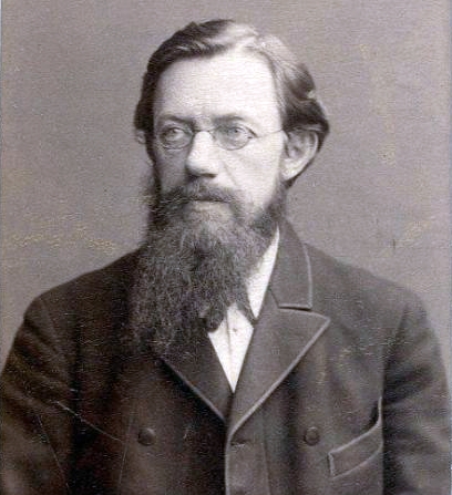
Valentina Morozova
Valentina Galaktionovna Morozova (March 13, 1910December 28, 1989) was a Soviet geologist and paleontologist. Morozova's most recognizable works in her field revolve around her stratigraphical research on the sediments from the Paleozoic, Cretaceous, Mesozoic and Cenozoic eras. Early life Valentina Galaktionovna Morozova was born March 13, 1910, in Saint Petersburg, Russian Empire. Both of her parents worked; her father as a railway engineer, and her mother working in the textile industry. At a young age, Valentina was accepted to the Ledovskaya Gymnasium in Leningrad, otherwise known as school no. 190, It was here, at age 15, where her interest in philosophy, religious experience, and psychology were sparked. While still attending school, Valentina, along with several of her classmates, had joined a political activism group. This group served against the views of the Russian government, which led to their temporary arrest in 1928. Although she only served six months in preven ... [...More Info...] [...Related Items...] OR: [Wikipedia] [Google] [Baidu] |
Geologist
A geologist is a scientist who studies the solid, liquid, and gaseous matter that constitutes Earth and other terrestrial planets, as well as the processes that shape them. Geologists usually study geology, earth science, or geophysics, although backgrounds in physics, chemistry, biology, and other sciences are also useful. Field research (field work) is an important component of geology, although many subdisciplines incorporate laboratory and digitalized work. Geologists can be classified in a larger group of scientists, called geoscientists. Geologists work in the energy and mining sectors searching for natural resources such as petroleum, natural gas, precious and base metals. They are also in the forefront of preventing and mitigating damage from natural hazards and disasters such as earthquakes, volcanoes, tsunamis and landslides. Their studies are used to warn the general public of the occurrence of these events. Geologists are also important contributors to climate ch ... [...More Info...] [...Related Items...] OR: [Wikipedia] [Google] [Baidu] |
Caucasus Mountains
The Caucasus Mountains, : pronounced * hy, Կովկասյան լեռներ, : pronounced * az, Qafqaz dağları, pronounced * rus, Кавка́зские го́ры, Kavkázskiye góry, kɐfˈkasːkʲɪje ˈɡorɨ * tr, Kafkas Dağları, * fa, كوه هاى قفقاز are a mountain range at the intersection of Asia and Europe. Stretching between the Black Sea and the Caspian Sea, they are surrounded by the Caucasus region and are home to Mount Elbrus, the list of elevation extremes by region, highest peak in Europe at above sea level. The Caucasus Mountains include the Greater Caucasus in the north and Lesser Caucasus in the south. The Greater Caucasus runs west-northwest to east-southeast, from the Western Caucasus, Caucasian Natural Reserve in the vicinity of Sochi, Russia on the northeastern shore of the Black Sea to Baku, Azerbaijan on the Caspian Sea. The Lesser Caucasus runs parallel to the Greater about south. The Greater and Lesser Caucasus ranges are co ... [...More Info...] [...Related Items...] OR: [Wikipedia] [Google] [Baidu] |
Soviet Geologists
This list of Russian Earth scientists includes the notable geographers, geologists, oceanographers, meteorologists, ecologists and other representatives of Earth sciences from the Russian Federation, the Soviet Union, the Russian Empire and other predecessor states of Russia. Alphabetical list __NOTOC__ A * Vladimir Abazarov, geologist, discoverer of Samotlor oil field, the largest Russian oil field *Dmitry Anuchin, anthropologist and geographer, coined the term "anthroposphere", determined the location of the Volga river source *Andrey Arkhangelsky, geologist B *Karl Baer, naturalist, formulated the geological Baer's law on river erosion, co-founder of the Russian Geographical Society *Valeri Barsukov, geologist *Vladimir Belousov, geologist *Lev Berg, determined the depth of Central Asian lakes, including Balkhash Lake and Issyk Kul, a head of the Soviet Geographical Society *Yuri Bilibin, geologist, studied placer geology and organized expeditions that discovered gold de ... [...More Info...] [...Related Items...] OR: [Wikipedia] [Google] [Baidu] |
1989 Deaths
File:1989 Events Collage.png, From left, clockwise: The Cypress Street Viaduct, Cypress structure collapses as a result of the 1989 Loma Prieta earthquake, killing motorists below; The proposal document for the World Wide Web is submitted; The Exxon Valdez oil tanker runs aground in Prince William Sound, Alaska, causing a large Exxon Valdez oil spill, oil spill; The Fall of the Berlin Wall begins the downfall of Communism in Eastern Europe, and heralds German reunification; The United States United States invasion of Panama, invades Panama to depose Manuel Noriega; The Singing Revolution led to the independence of the Baltic states of Estonia, Latvia, and Lithuania from the Soviet Union; The stands of Hillsborough Stadium in Sheffield, Yorkshire, where the Hillsborough disaster occurred; 1989 Tiananmen Square protests and massacre, Students demonstrate in Tiananmen Square, Beijing; many are killed by forces of the Chinese Communist Party., 300x300px, thumb rect 0 0 200 200 1989 Loma ... [...More Info...] [...Related Items...] OR: [Wikipedia] [Google] [Baidu] |
1910 Births
Year 191 ( CXCI) was a common year starting on Friday (link will display the full calendar) of the Julian calendar. At the time, it was known as the Year of the Consulship of Apronianus and Bradua (or, less frequently, year 944 ''Ab urbe condita''). The denomination 191 for this year has been used since the early medieval period, when the Anno Domini calendar era became the prevalent method in Europe for naming years. Events By place Parthia * King Vologases IV of Parthia dies after a 44-year reign, and is succeeded by his son Vologases V. China * A coalition of Chinese warlords from the east of Hangu Pass launches a punitive campaign against the warlord Dong Zhuo, who seized control of the central government in 189, and held the figurehead Emperor Xian hostage. After suffering some defeats against the coalition forces, Dong Zhuo forcefully relocates the imperial capital from Luoyang to Chang'an. Before leaving, Dong Zhuo orders his troops to loot the tombs of the Ha ... [...More Info...] [...Related Items...] OR: [Wikipedia] [Google] [Baidu] |
Talysh Mountains
Talysh Mountains ( tly, Tolışə Bandon, script=Latn, fa, کوههای تالش, Kuhhâye Tâleš; az, Talış dağları) is a mountain range in far southeastern Azerbaijan and far northwestern Iran within Ardabil Province and Gilan Province. They are a northwestern subrange of the Alborz Mountains that run along the southern Caspian Sea on the Iranian Plateau. Geography The Talysh Mountains extend southeastward from the Lankaran Lowland in southeastern Azerbaijan to the lower part of the Sefid Rud (''White River'') in northwestern Iran. A few peaks rise above 10,000 ft (3,000 m). Geology Geologically, the Talish Mountain Range is made mainly of the Late Cretaceous volcano-sedimentary deposits with a strip of Paleozoic rocks and a band of Triassic and Jurassic rocks in the southern parts, both in a north-west-southeast direction. Ecology The maximum annual precipitation in the Talysh Mountains is between 1,600 mm to 1,800 mm, which along the Lankaran L ... [...More Info...] [...Related Items...] OR: [Wikipedia] [Google] [Baidu] |
Kopet Dag
The Köpet Dag, Kopet Dagh, or Koppeh Dagh ( tk, Köpetdag; fa, کپهداغ), also known as the Turkmen-Khorasan Mountain Range, is a mountain range on the border between Turkmenistan and Iran that extends about along the border southeast of the Caspian Sea, stretching northwest-southeast from near the Caspian Sea in the northwest to the Harirud River in the southeast. In the southwest it borders on the parallel eastern endings of the Alborz mountains being together part of the much larger Alpide belt. The highest peak of the range in Turkmenistan is the Mount Rizeh (Kuh-e Rizeh), located at the southwest of the capital Ashgabat and stands at . The highest Iranian summit is Mount Quchan (Kuh-e Quchan) with . Etymology Vambery conjectured that ''köpet'' originates from the Turkmen language where "köp" means "a lot" or "many" and the word "dag" means "mountain" or "peak". He thus translated Köpetdag as "Many mountains (peaks)". He and others noted that in Persian ''koppe ... [...More Info...] [...Related Items...] OR: [Wikipedia] [Google] [Baidu] |
Türkmenbaşy, Turkmenistan
Türkmenbaşy ( Turkmen Cyrillic: Түркменбашы, Turkmen Arabic; توركمنباشی, also spelled Turkmenbashi, a back-formation of the Cyrillic Түркменбаши), formerly known as Krasnovodsk (russian: Красноводск), Kyzyl-Su, and Shagadam ( tk, Şagadam), is a city in Balkan Province in Turkmenistan, on the Türkmenbaşy Gulf of the Caspian Sea. It sits at an elevation of . The population (est 2004) was 86,800, mostly ethnic Turkmens but also Russian, Armenian and Azeri minorities. As the terminus of the Trans-Caspian Railway and site of a major seaport on the Caspian, it is an important transportation center. The city is also the site of Turkmenistan's largest oil refining complex. This city should not be confused with the similarly named town of Türkmenbaşy ( tk, Türkmenbaşy şäherçesi), formerly called Janga (russian: Джанга, Cyrillic tk, Җанга), also in Balkan Province, or the city of Saparmyrat Türkmenbaşy adyndaky in Daş ... [...More Info...] [...Related Items...] OR: [Wikipedia] [Google] [Baidu] |
Mangyshlak Peninsula
Mangyshlak or Mangghyshlaq Peninsula ( kk, Маңғыстау түбегі, translit=Mañğystau tübegı; russian: Полуостров Мангышла́к, translit=Poluostrov Mangyshlák) is a large peninsula located in western Kazakhstan. It borders on the Caspian Sea in the west and with the Buzachi Peninsula, a marshy sub-feature of the main peninsula, in the northeast. The Tyuleniy Archipelago lies off the northern shores of the peninsula. The area is between desert and semidesert with a harsh continental dry climate. There are no rivers and no fresh water springs. Geologically, the Mangyshlak Peninsula is part of the Ustyurt Plateau. To the north, three mountain ranges stretch across the peninsula, the North and South Aktau Range and the Mangystau Range, with the highest point reaching 555 m. Administratively, the peninsula is in Kazakhstan's Mangystau Province. The largest city, and the capital of the province, is Aktau (formerly Shevchenko). This peninsula was former ... [...More Info...] [...Related Items...] OR: [Wikipedia] [Google] [Baidu] |
East European Platform
East European Platform or Russian Platform is a large and flat area covered by sediments in Eastern Europe spanning from the Ural Mountains to the Tornquist Zone and from the Peri-Caspian Basin to the Barents Sea. Over geological time the platform area has experienced extension, inversion and compression. It has an area of about 6 million km2. The East European Platform sediments can be classified into the following groups: a "protoplatform" of metamorphosed sediments at the bottom, a "quasiplatform" of slightly deformed sediments, a "cataplatform", and a "orthoplatform" at the top. The Mesoproterozoic Jotnian sediments of the Baltic area are examples of a "quasiplatform". The oldest preserved continuous sedimentary cover in the platform date to the Vendian about 650 million years ago. The cycles of deposition of platform sediments are related to the development of nearby orogenies like the Timanide orogeny, the Uralian orogeny, the Hercynian orogeny and the Caledonian orogeny ... [...More Info...] [...Related Items...] OR: [Wikipedia] [Google] [Baidu] |
Paleontology
Paleontology (), also spelled palaeontology or palæontology, is the scientific study of life that existed prior to, and sometimes including, the start of the Holocene epoch (roughly 11,700 years before present). It includes the study of fossils to classify organisms and study their interactions with each other and their environments (their paleoecology). Paleontological observations have been documented as far back as the 5th century BC. The science became established in the 18th century as a result of Georges Cuvier's work on comparative anatomy, and developed rapidly in the 19th century. The term itself originates from Greek (, "old, ancient"), (, ( gen. ), "being, creature"), and (, "speech, thought, study"). Paleontology lies on the border between biology and geology, but differs from archaeology in that it excludes the study of anatomically modern humans. It now uses techniques drawn from a wide range of sciences, including biochemistry, mathematics, and engineering. ... [...More Info...] [...Related Items...] OR: [Wikipedia] [Google] [Baidu] |


_Talış_dağları_088.jpg)
.jpg)

