|
Upper Kolyma Highlands
The Upper Kolyma Highlands ( rus, Верхнеколымское нагорье) is a highland area in Magadan Oblast, Far Eastern Federal District, Russia. The biggest town in the highlands is Susuman. There are large deposits of gold, tin and rare metals in the Upper Kolyma Highlands. The area is relatively less desolate than other mountainous zones of Northeastern Siberia, such as the Yukaghir Highlands or the Nera Plateau. However, some of the mining operations were deemed unprofitable following the collapse of the USSR and certain settlements of the Susumansky District lost population. Only a residual population remains in Shiroky, Kholodny and Bolshevik. Other places such as Belichan and Kadykchan have become ghost towns. The R504 Kolyma Highway crosses the southern part of the highlands. Geography The Upper Kolyma Highlands are located in the upper course of the Kolyma. They are bound in the west by the Tas-Kystabyt and Suntar-Khayata ranges and to the east by the ... [...More Info...] [...Related Items...] OR: [Wikipedia] [Google] [Baidu] |
Larch
Larches are deciduous conifers in the genus ''Larix'', of the family Pinaceae (subfamily Laricoideae). Growing from tall, they are native to much of the cooler temperate northern hemisphere, on lowlands in the north and high on mountains further south. Larches are among the dominant plants in the boreal forests of Siberia and Canada. Although they are conifers, larches are deciduous trees that lose their needles in the autumn. Etymology The English name Larch ultimately derives from the Latin "larigna," named after the ancient settlement of Larignum. The story of its naming was preserved by Vitruvius: It is worth while to know how this wood was discovered. The divine Caesar, being with his army in the neighbourhood of the Alps, and having ordered the towns to furnish supplies, the inhabitants of a fortified stronghold there, called Larignum, trusting in the natural strength of their defences, refused to obey his command. So the general ordered his forces to the assault. In ... [...More Info...] [...Related Items...] OR: [Wikipedia] [Google] [Baidu] |
Susumansky District
Susumansky District (russian: Сусума́нский райо́н) is an administrative district (raion), one of the eight in Magadan Oblast, Russia.Law #1292-OZ As a municipal division, it is incorporated as Susumansky Urban Okrug.Law #1886-OZ It is located in the southeast of the oblast and borders the Sakha Republic in the west and north, Srednekansky District in the east, and Yagodninsky and Tenkinsky Districts in the south. The area of the district is . Its administrative center is the town of Susuman. As of the 2010 Census, the total population of the district was 9,015, with the population of Susuman accounting for 65.0% of that number. Geography The landscape of the district is mostly mountainous. The Nera Plateau and the Tas-Kystabyt are located in the northwestern part of the district.Google Earth History The district was established on December 2, 1953. Administrative and municipal status Within the framework of administrative divisions, Susumansky Dis ... [...More Info...] [...Related Items...] OR: [Wikipedia] [Google] [Baidu] |
Ola (river)
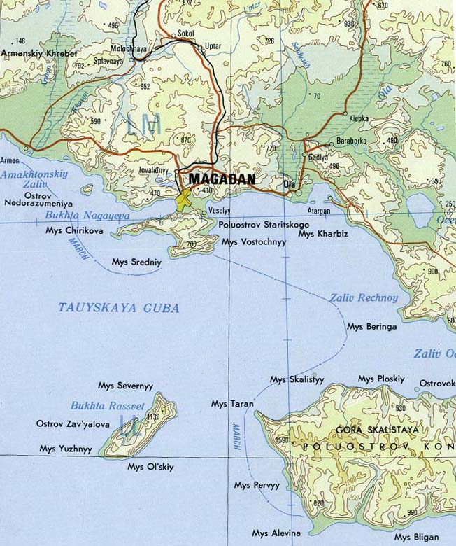
The Ola ( rus, Ола) is a river in Magadan Oblast, Russian Far East. It is long, with a drainage basin of . The R504 Kolyma Highway crosses the Ola about north of its mouth. Course The river has its source in the Olsky Plateau, at the eastern end of the Upper Kolyma Highlands, southwest of Atka at an elevation of . It flows SSE for about then it bends and flows SSW across the Ola Lowland, bending again and flowing roughly southwards. Its last stretch is among wetlands between Magadan and Lake Chistoye. Finally it flows in the Taui Bay of the Sea of Okhotsk.Google Earth Ola, the administrative center of Ola District is located at the mouth of the river. The main tributary of the Ola is the Lankovaya that joins it in its lower course from the left. See also *List of rivers of Russia Russia can be divided into a European and an Asian part. The dividing line is generally considered to be the Ural Mountains. The European part is drained into the Arctic Ocean, Baltic ... [...More Info...] [...Related Items...] OR: [Wikipedia] [Google] [Baidu] |
Buyunda
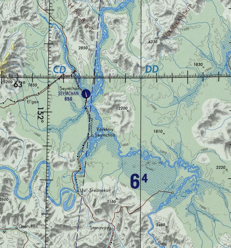
The Buyunda (russian: Буюнда) is a river in Magadan Oblast, Russian Far East. It is a right tributary of the Kolyma, with a length of and a drainage basin of .Google Earth Together with the Seymchan that flows roughly southwards on the facing bank of the Kolyma basin, the Buyunda forms the Seymchan-Buyunda Depression, which limits the Upper Kolyma Highlands from the east. The name of the Buyunda originated in the Evenki language, meaning "where there are wild deer". Course The Buyunda is the seventh longest tributary of the Kolyma. It has its sources in the Kilgan Massif and heads roughly northwards across the mountainous area of the Maymandzhin Range. After entering the depression it meanders strongly across a wide and marshy floodplain, its main channel dividing into branches. Finally the river joins the right bank of the Kolyma from its mouth. Its confluence with the Kolyma is 100 km below the Ust-Srednekan Hydroelectric Station. Seymchan settlement and the ... [...More Info...] [...Related Items...] OR: [Wikipedia] [Google] [Baidu] |
Seymchan (Kolyma)
The Seymchan (russian: Сеймчан) is a river in Srednekansky District, Magadan Oblast, Russia. It is a left tributary of the Kolyma, with a length of a drainage basin of . The name comes from the Yakut language word Kheymchen, which is an area of open water surrounded by sea ice.W.J. Stringer and J.E. Groves. 1991''Extent of Polynyas in the Bering and Chukchi Seas''/ref> Course The river rises in the Upper Kolyma Highlands, eastern limits of the Chersky Range, at the confluence of Left Seymchan and Right Seymchan. It flows first in a northeast direction, bending along its course until it flows in a southeastern direction. Finally it meets the Kolyma near Seymchan, from its mouth, downstream from the mouth of the Buyunda on the opposite bank. Together with the Buyunda that flows roughly northwards on the other side of the Kolyma basin, the Seymchan forms the Seymchan-Buyunda Depression, which limits the Upper Kolyma Highlands from the east. Its main tributaries are the ... [...More Info...] [...Related Items...] OR: [Wikipedia] [Google] [Baidu] |
Suntar-Khayata
Suntar-Khayata Range (russian: Сунтар-Хаята, sah, Сунтаар Хайата) is a granite mountain range rising along the border of the Sakha Republic in the north with Amur Oblast and Khabarovsk Krai in the south. The R504 Kolyma Highway passes through the northern part of the range by Kyubeme. Geography The Suntar-Khayata is approximately 450–550 km long and 60 km wide. high Mus-Khaya Mountain, located in the Sakha Republic, is the highest point of the range. Berill Mountain, at is the highest summit in Khabarovsk Krai. Mount Khakandya (Гора Хакандя) is an ultra-prominent peak that is high. The Suntar-Khayata Range is geographically a southeastern prolongation of the Verkhoyansk Range. Until mid 20th century it was treated as a separate range, together with the Skalisty Range, highest point , and the Sette Daban, highest point , to the southwest. The Yudoma-Maya Highlands are located to the south of the range [...More Info...] [...Related Items...] OR: [Wikipedia] [Google] [Baidu] |
Tas-Kystabyt
The Tas-Kystabyt ( rus, Тас-Кыстабыт, sah, Таас Кыстаабыт) is a mountain range in the Sakha Republic and Magadan Oblast, Far Eastern Federal District, Russia. It is also known as "хребе́т Са́рычева" —Sarychev Range, in honor of 19th century Russian cartographer Admiral Gavril Sarychev.Тас-Кыстабыт — in 30 vols. / Ch. ed. A.M. Prokhorov - 3rd ed. - M, 1969–1978 Geography The Tas-Kystabyt rises in the southeasternmost sector of the |
Kolyma (river)
The Kolyma ( rus, Колыма, p=kəlɨˈma; sah, Халыма, translit=Khalyma) is a river in northeastern Siberia, whose basin covers parts of the Sakha Republic, Chukotka Autonomous Okrug, and Magadan Oblast of Russia. The Kolyma is frozen to depths of several metres for about 250 days each year, becoming free of ice only in early June, until October. Course The Kolyma begins at the confluence of the Kulu and the Ayan-Yuryakh, originating in the Khalkan Range and flows across the Upper Kolyma Highlands in its upper course. Leaving the mountainous areas it flows roughly northwards across the Kolyma Lowland, a vast plain dotted with thousands of lakes, part of the greater East Siberian Lowland. The river empties into the Kolyma Gulf of the East Siberian Sea, a division of the Arctic Ocean. The Kolyma is long. The area of its basin is . The average discharge at Kolymskoye is , with a high of reported in June 1985, and a low of in April 1979. Tributaries The ma ... [...More Info...] [...Related Items...] OR: [Wikipedia] [Google] [Baidu] |
R504 Kolyma Highway
The R504 Kolyma Highway (russian: Федеральная автомобильная дорога «Колыма», ''Federal'naya Avtomobil'naya Doroga «Kolyma»,'' "Federal Automobile Highway 'Kolyma'"), part of the M56 route, is a road through the Russian Far East. It connects Magadan with the town of Nizhny Bestyakh, located on the eastern bank of Lena River, opposite of Yakutsk. At Nizhny Bestyakh the Kolyma Highway connects to the Lena Highway. The Kolyma Highway is colloquially known as the Road of Bones (Russian: Дорога Костей, transliteration: ''Doróga Kostyéy''), in reference to the hundreds of thousands of forced laborers who were interred in the pavement after dying during its construction. Locally, the road is known as the Kolyma Route (Russian: Колымская трасса, transliteration: ''Kolýmskaya trássa''). History The Dalstroy construction directorate built the Kolyma Highway during the Soviet Union's Stalinist era. Inmates of the ... [...More Info...] [...Related Items...] OR: [Wikipedia] [Google] [Baidu] |
Ghost Town
Ghost Town(s) or Ghosttown may refer to: * Ghost town, a town that has been abandoned Film and television * Ghost Town (1936 film), ''Ghost Town'' (1936 film), an American Western film by Harry L. Fraser * Ghost Town (1956 film), ''Ghost Town'' (1956 film), an American Western film by Allen H. Miner * Ghost Town (1988 film), ''Ghost Town'' (1988 film), an American horror film by Richard McCarthy (as Richard Governor) * Ghost Town (2008 film), ''Ghost Town'' (2008 film), an American fantasy comedy film by David Koepp * ''Ghost Town'', a 2008 TV film featuring Billy Drago * ''Derek Acorah's Ghost Towns'', a 2005–2006 British paranormal reality television series * Ghost Town (CSI: Crime Scene Investigation), "Ghost Town" (''CSI: Crime Scene Investigation''), a 2009 TV episode Literature * Ghost Town (Lucky Luke), ''Ghost Town'' (''Lucky Luke'') or ''La Ville fantôme'', a 1965 ''Lucky Luke'' comic *''Ghost Town'', a Beacon Street Girls novel by Annie Bryant *''Ghost Town'', a 199 ... [...More Info...] [...Related Items...] OR: [Wikipedia] [Google] [Baidu] |
Kadykchan
Kadykchan (russian: Кадыкча́н) is a depopulated urban locality (a work settlement) in Susumansky District of Magadan Oblast, Russia. It is located in the Upper Kolyma Highlands, in the basin of the Ayan-Yuryakh River, northwest of Susuman, the administrative center of the district. As of the 2010 Census, it had no recorded population. Etymology The settlement's name comes from the indigenous Even language word meaning "small gorge" or "ravine". History Kadykchan was built by gulag prisoners during World War II for the purposes of coal extraction. Later it accommodated miners at two local coal mines which supplied Arkagalinskaya electric power station. The depth of mines was about . After the dissolution of the Soviet Union The dissolution of the Soviet Union, also negatively connoted as rus, Разва́л Сове́тского Сою́за, r=Razvál Sovétskogo Soyúza, ''Ruining of the Soviet Union''. was the process of internal disintegration within the S ... [...More Info...] [...Related Items...] OR: [Wikipedia] [Google] [Baidu] |
Belichan
Belichan (russian: Беличан) is an urban locality (an urban-type settlement) in Susumansky District of Magadan Oblast, Russia. Population: Geography Belichan is located in the Upper Kolyma Highlands by the Byoryolyokh The Byoryolyokh (russian: Бёрёлёх, References Urban-type settlements in Magadan Oblast {{MagadanOblast-geo-stub ...[...More Info...] [...Related Items...] OR: [Wikipedia] [Google] [Baidu] |
.jpg)


