|
Unterlunkhofen
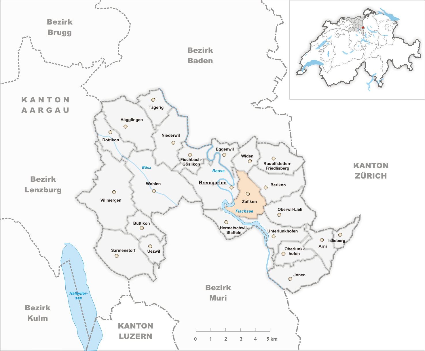
Unterlunkhofen is a municipality in the district of Bremgarten in the canton of Aargau in Switzerland. History Since pre-Christian times people have inhabited the areas around Unterlunkhofen. Archeological digs document a settlement of the ''Geisshof'' area since the Neolithic Age (Horgen Culture, ca 2700-2400 BC). There are other significant discoveries from the early Iron Age (ca 800-450 BC), including the ''Bärhau'' burial site which is the largest of its kind in Switzerland. The area near the municipality also included a Roman era villa. In 1890 a Roman wall with marble facing and a magnificent six-color mosaic floor was excavated.Unterlunkhofen municipal website-History accessed 3 March 2010 [...More Info...] [...Related Items...] OR: [Wikipedia] [Google] [Baidu] |
Bremgarten (district)
Bremgarten District is a Swiss district in the Canton of Aargau, corresponding to the valleys of the Reuss and Bünz rivers in the area known as the ''Freiamt''. Geography Bremgarten District has an area, , of . Of this area, 48.7% is used for agricultural purposes, while 30.9% is forested. The rest of the land, (18.1%) is settled. Demographics Bremgarten District has a population of (as of ). , there were 2,402 homes with 1 or 2 persons in the household, 11,781 homes with 3 or 4 persons in the household, and 9,773 homes with 5 or more persons in the household. The average number of people per household was 2.43 individuals. there were 10,969 single family homes (or 37.2% of the total) out of a total of 29,488 homes and apartments.Statistical Department of Canton Aargau accessed 20 January 2010 There were a total of 479 em ... [...More Info...] [...Related Items...] OR: [Wikipedia] [Google] [Baidu] |
Oberlunkhofen
Oberlunkhofen is a municipality in the district of Bremgarten, in the canton of Aargau in Switzerland. History The earliest signs of a settlement in Oberlunkhofen are scattered Bronze Age items. In Schalchmatthau there is the foundation of a rectangular Roman era farm with a portico and flanked by two wings. Also from the Roman era, there is a 1-3rd Century villa and a bathhouse with heated rooms. Near the villa, an Alemanni graveyard was also discovered. During initial excavation, the wall remains were uncovered in 1897-98. Then, between 1975-80 the wall ruins were preserved. The modern village of Oberlunkhofen is first mentioned in the 9th Century as ''Lunchunft'' though this record comes from an 11th Century copy of the original, older document. In 1232 it was mentioned as ''Lunchuft'' and in 1309 as ''obern Lunchuft''. There was a castle near the village, but no surviving records mention it. It was presumably destroyed in 1386. The village was owned by St. Leode ... [...More Info...] [...Related Items...] OR: [Wikipedia] [Google] [Baidu] |
Rottenschwil
Rottenschwil is a municipality in the district of Muri in the canton of Aargau in Switzerland. History The earliest trace of a human settlement in the area around Rottenschwil, is a Roman era farm. The modern municipality of Rottenschwil is first mentioned in 1281 as ''Rotolfswile''. The major land owner in the area was Hermetschwil Abbey, but the Habsburgs held the vogtei office over the Abbey's land. With the conquest of the Aargau in 1415 those rights transferred to the Swiss Confederation. From 1415 until 1798, Rottenschwil was a part of the district of Muri in the Freie Ämter, which were governed as "subject lands" by all or some of the Confederates. A ferry over the Reuss river is first mentioned in 1312. In 1510, Muri Abbey sold their quarter of the profits from the ferry to the city of Bremgarten. Frequent floods strongly affected the population and buildings. In 1580 Hermetschwil Abbey helped construct a milldam on the river. During the Helvetic Republic (1798 ... [...More Info...] [...Related Items...] OR: [Wikipedia] [Google] [Baidu] |
Reuss (river)
The Reuss (Swiss German: ''Rüüss'') is a river in Switzerland. With a length of and a drainage basin of , it is the fourth largest river in Switzerland (after the Rhine, Aare and Rhône). The upper Reuss forms the main valley of the canton of Uri. The course of the lower Reuss runs from Lake Lucerne to the confluence with the Aare at Brugg and Windisch. The Reuss is one of the four major rivers taking their source in the Gotthard region, along with the Rhine, Ticino and Rhône. Geography Course The Gotthardreuss rises in the Gotthard massif, emerging from Lago di Lucendro (reservoir built in 1947; elevation 2,131 m) in the canton of Ticino and passing into the canton of Uri below the ''Brigghubel'' (1,898 m). The Furkareuss rises east of Furka Pass (2,429 m), early joined by the ''Blaubergbach'' (sourced by two mountain lakes on 2,649 m) and several other creeks sourced by still existing glaciers, such as ''Sidelengletscher'' (3,170 m) ... [...More Info...] [...Related Items...] OR: [Wikipedia] [Google] [Baidu] |
Hermetschwil-Staffeln
Hermetschwil-Staffeln is a former municipality in the district of Bremgarten in the canton of Aargau in Switzerland. On 1 January 2014 the former municipality of Hermetschwil-Staffeln merged into the municipality of Bremgarten.Nomenklaturen – Amtliches Gemeindeverzeichnis der Schweiz accessed 13 December 2014 History Hermetschwil-Staffeln is first mentioned in 1064 as ''Hermenswil''. In 1390 it was mentioned as ''Hermeczwil''. The village grew up around Hermetschwil Convent. While the region was under control, the village was under the authority of the town of Muri. |
Oberwil-Lieli
Oberwil-Lieli is a municipality in the district of Bremgarten in the canton of Aargau in Switzerland. History During the Roman era the municipal area was lightly settled. On the site of the current church there was a Roman farm. The ruins of an Alemanni settlement was also discovered in the municipality. Oberwil-Lieli is first mentioned in 1040 as ''Willare'' in a land grant to Einsiedeln Abbey. During the 12th Century, Engelberg and Muri Abbey were also given grants in the village. The rights to high and low justice were held by the Counts of Habsburg-Laufenburg. Their rights came in the 14th Century to the lords of Schönenwerd and the knight Heinrich Biber, but in 1352 they went to the Family Stagel of Zurich. In 1429, the sovereign rights were granted to Bremgarten. After 1415 Oberwil was under the high justice of the city of Zurich. The ''Kollatur'' (first mentioned in 1186) went out from under the authority of Engelberg Abbey in 1303 to the hospital at Ko ... [...More Info...] [...Related Items...] OR: [Wikipedia] [Google] [Baidu] |
Zufikon
Zufikon is a municipality in the district of Bremgarten in the canton of Aargau in Switzerland. History A single archeological find dates human habitation in the area to the Bronze Age. The first written reference to the village occurred in 1150. Geography Zufikon has an area, , of . Of this area, 49.9% is used for agricultural purposes, while 27.1% is forested. Of the rest of the land, 20.7% is settled (buildings or roads) and the remainder (2.3%) is non-productive (rivers or lakes). Coat of arms The blazon of the municipal coat of arms is ''Argent a Pale Sable between two Keys palewise Azure with wards downwards and inwards.'' accessed 4 March 2010 Demographics Zufikon has a population (as of ) of . , 17.4% of the population was made up of foreign nationals.[...More Info...] [...Related Items...] OR: [Wikipedia] [Google] [Baidu] |
Arni, Aargau
Arni is a municipality in the district of Bremgarten in the Swiss canton of Aargau. History Arni is first mentioned in 1184 as ''Arne''. In 1983 the, already independent, village of Islisberg separated from the municipality of Arni-Islisberg to form the municipalities of Arni, AG and Islisberg.Amtliches Gemeindeverzeichnis der Schweiz published by the Swiss Federal Statistical Office accessed 14 January 2010 Geography [...More Info...] [...Related Items...] OR: [Wikipedia] [Google] [Baidu] |
High, Middle And Low Justice
High, middle and low justices are notions dating from Western feudalism to indicate descending degrees of judicial power to administer justice by the maximal punishment the holders could inflict upon their subjects and other dependents. Low justice regards the level of day-to-day civil actions, including voluntary justice, minor pleas, and petty offences generally settled by fines or light corporal punishment. It was held by many lesser authorities, including many lords of the manor, who sat in justice over the serfs, unfree tenants, and freeholders on their land. Middle justice would involve full civil and criminal jurisdiction, except for capital crimes, and notably excluding the right to pass the death penalty, torture and severe corporal punishment, which was reserved to authorities holding high justice, or the ''ius gladii'' ("right of the sword"). Pyramid of feudal justice Although the terms ''high'' and ''low'' suggest a strict subordination, this was not quite the ca ... [...More Info...] [...Related Items...] OR: [Wikipedia] [Google] [Baidu] |
House Of Habsburg
The House of Habsburg (), alternatively spelled Hapsburg in Englishgerman: Haus Habsburg, ; es, Casa de Habsburgo; hu, Habsburg család, it, Casa di Asburgo, nl, Huis van Habsburg, pl, dom Habsburgów, pt, Casa de Habsburgo, la, Domus Habsburg, french: Maison des Habsbourg and also known as the House of Austriagerman: link=no, Haus Österreich, ; es, link=no, Casa de Austria; nl, Huis van Oostenrijk, pl, dom Austrii, la, Domus Austriæ, french: Maison d'Autriche; hu, Ausztria Háza; it, Casa d'Austria; pt, Casa da Áustria is one of the most prominent and important dynasties in European history. The house takes its name from Habsburg Castle, a fortress built in the 1020s in present-day Switzerland by Radbot of Klettgau, who named his fortress Habsburg. His grandson Otto II was the first to take the fortress name as his own, adding "Count of Habsburg" to his title. In 1273, Count Radbot's seventh-generation descendant Rudolph of Habsburg was elected King of the ... [...More Info...] [...Related Items...] OR: [Wikipedia] [Google] [Baidu] |
Rudolf I Of Germany
Rudolf I (1 May 1218 – 15 July 1291) was the first King of Germany from the House of Habsburg. The first of the count-kings of Germany, he reigned from 1273 until his death. Rudolf's election marked the end of the Great Interregnum which had begun after the death of the Hohenstaufen Emperor Frederick II in 1250. Originally a Swabian count, he was the first Habsburg to acquire the duchies of Austria and Styria in opposition to his mighty rival, the Přemyslid king Ottokar II of Bohemia, whom he defeated in the 1278 Battle on the Marchfeld. The territories remained under Habsburg rule for more than 600 years, forming the core of the Habsburg monarchy and the present-day country of Austria. Rudolf played a vital role in raising the comital House of Habsburg to the rank of Imperial princes. Early life Rudolf was born on 1 May 1218 at Limburgh Castle near Sasbach am Kaiserstuhl in the Breisgau region of present-day southwestern Germany. He was the son of Count Albert IV of ... [...More Info...] [...Related Items...] OR: [Wikipedia] [Google] [Baidu] |


_c1640_Rudolf_I.jpg)