|
Ungava (electoral District)
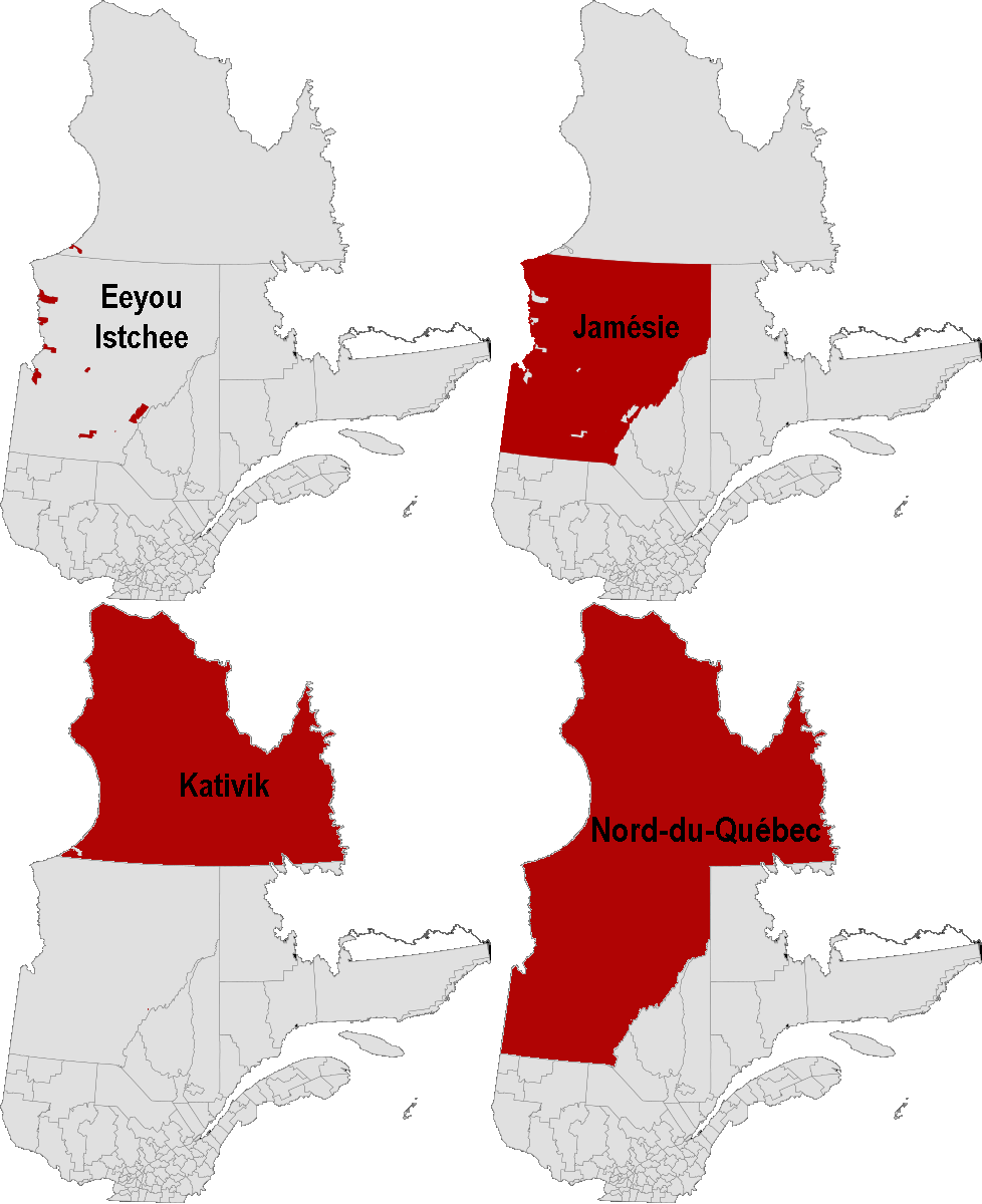
Ungava is a provincial electoral district in the Nord-du-Québec region of Quebec, Canada that elects members to the National Assembly of Quebec. It includes all of the Nord-du-Québec region (which is also a single census division) except for the Naskapi village municipality of Kawawachikamach. It covers the Ungava Peninsula of northern Quebec and notably includes the municipalities and communities of Chibougamau, Chisasibi, Mistissini, Kuujjuaq, Eeyou Istchee Baie James, Waskaganish, Puvirnituq, Lebel-sur-Quévillon, Inukjuak and Wemindji. It was created for the 1981 election from Abitibi-Est and Abitibi-Ouest electoral districts. In the change from the 2001 to the 2011 electoral map, it lost the unorganized territories of Caniapiscau and Lac-Juillet (in Côte-Nord region) to Duplessis electoral district. Members of the National Assembly Election results ^ Change is from redistributed results. CAQ change is from ... [...More Info...] [...Related Items...] OR: [Wikipedia] [Google] [Baidu] |
Nord-du-Québec
Nord-du-Québec (; en, Northern Quebec) is the largest, but the least populous, of the seventeen administrative regions of Quebec, Canada. With nearly of land area, and very extensive lakes and rivers, it covers much of the Labrador Peninsula and about 55% of the total land surface area of Quebec, while containing a little more than 0.5% of the population. Before 1912, the northernmost part of this region was part of the Ungava District of the Northwest Territories, and until 1987 it was referred to as Nouveau-Québec, or ''New Quebec''. It is bordered by Hudson Bay and James Bay in the west, Hudson Strait and Ungava Bay in the north, Labrador in the northeast, and the administrative regions of Abitibi-Témiscamingue, Mauricie, Saguenay–Lac-Saint-Jean, and Côte-Nord in the south and southeast. The Nord-du-Québec region is part of the territory covered by the James Bay and Northern Quebec Agreement of 1975; other regions covered (in part) by this Agreement include Côt ... [...More Info...] [...Related Items...] OR: [Wikipedia] [Google] [Baidu] |
Mistissini (Cree Village Municipality)
Mistissini ( cr, ᒥᔅᑎᓯᓃ/Mistisinî meaning Big Rock) is a Cree village municipality in the territory of Eeyou Istchee in northern Quebec, Canada; it has a distinct legal status and classification from other kinds of village municipalities in Quebec: Naskapi village municipalities, northern villages (Inuit communities), and ordinary villages. As with all other Cree village municipalities in Quebec, there is a counterpart Cree reserved land of the same name located nearby: Mistissini. Despite the title of "village municipality" and the formalities that go along with it (for instance, having a mayor), Statistics Canada lists it (and all other Cree village municipalities in Quebec) as having few resident population or residential infrastructure (dwellings); it is the Cree reserved lands that are listed as having most of the population and residential dwellings in the 2021 census, the 2016 census, and earlier censuses. Geography The village is located on the Watso pe ... [...More Info...] [...Related Items...] OR: [Wikipedia] [Google] [Baidu] |
Aupaluk (Inuit Reserved Land)
Aupaluk ( iu, ᐊᐅᐸᓗᒃ) is an Inuit reserved land (Category I land for Inuit) in Nunavik, in northern Quebec. Like all Inuit reserved lands in Quebec, it has no resident population (as of the Canada 2011 Census and previous censuses) and is associated with a nearby northern village of the same name: Aupaluk Aupaluk ( iu, ᐊᐅᐸᓗᒃ) ( 2021 Population: 233) is a northern village in Nunavik, in the Nord-du-Québec region of Quebec. It is the least-populous Inuit community in Nunavik. The name means "where the earth is red", referring to its .... The Inuit reserved land of Aupaluk consists of three non-contiguous tracts of land, only one of which is adjacent to the northern village of the same name. References {{coord, 59, 16, 48, N, 69, 30, 00, W, region:CA_type:city_source:kolossus-frwiki, display=title Inuit reserved lands in Quebec ... [...More Info...] [...Related Items...] OR: [Wikipedia] [Google] [Baidu] |
Akulivik (Inuit Reserved Land)
Akulivik ( iu, ᐊᑯᓕᕕᒃ) is an Inuit reserved land (Category I land for Inuit) in Nunavik, in northern Quebec. Like all Inuit reserved lands in Quebec, it has no resident population (as of the Canada 2011 Census and previous censuses) and is associated with a nearby northern village of the same name: Akulivik Akulivik ( iu, ᐊᑯᓕᕕᒃ) ( 2021 population 642) is an Inuit village in Nunavik, in northern Quebec, Canada. It is located on a peninsula that juts southwesterly into Hudson Bay across from Smith Island, Nunavut (Qikirtajuaq). Akulivik l .... References {{coord, 60, 51, N, 77, 54, W, region:CA_type:city_source:kolossus-frwiki, display=title Inuit reserved lands in Quebec ... [...More Info...] [...Related Items...] OR: [Wikipedia] [Google] [Baidu] |
Whapmagoostui (Cree Village Municipality)
Whapmagoostui ( cr, ᐙᐱᒫᑯᔥᑐᐃ/Wâpimâkuštui, "place of the beluga") is a Cree village municipality in the territory of Eeyou Istchee in northern Quebec; it has a distinct legal status and classification from other kinds of village municipalities in Quebec: Naskapi village municipalities, northern villages (Inuit communities), and ordinary villages. As with all other Cree village municipalities in Quebec, there is a counterpart Cree reserved land of the same name located nearby: Whapmagoostui. Despite the title of "village municipality" and the formalities that go along with it (for instance, having a mayor), Statistics Canada lists it (and all other Cree village municipalities in Quebec) as having no resident population or residential infrastructure (dwellings); it is the Cree reserved lands that are listed as having population and residential dwellings in the 2011 census, the 2006 census, and earlier censuses. Demographics In the 2021 Census of Population ... [...More Info...] [...Related Items...] OR: [Wikipedia] [Google] [Baidu] |
Wemindji (Cree Village Municipality)
Wemindji ( cr, ᐐᒥᓂᒌ/Wîminicî) is a Cree village municipality in the territory of Eeyou Istchee in northern Quebec; it has a distinct legal status and classification from other kinds of village municipalities in Quebec: Naskapi village municipalities, northern villages (Inuit communities), and ordinary villages. As with all other Cree village municipalities in Quebec, there is a counterpart Cree reserved land of the same name located nearby: Wemindji. Despite the title of "village municipality" and the formalities that go along with it (for instance, having a mayor), Statistics Canada lists it (and all other Cree village municipalities in Quebec) as having no resident population or residential infrastructure (dwellings); it is the Cree reserved lands that are listed as having population and residential dwellings in the 2011 census, the 2006 census, and earlier censuses. Demographics In the 2021 Census of Population The 2021 Canadian census was a detailed enume ... [...More Info...] [...Related Items...] OR: [Wikipedia] [Google] [Baidu] |
Waswanipi (Cree Village Municipality)
Waswanipi ( cr, ᐙᔂᓂᐲ or Wâswânipî) is a Cree village municipality in the territory of Eeyou Istchee in northern Quebec; it has a distinct legal status and classification from other kinds of village municipalities in Quebec: Naskapi village municipalities, northern villages (Inuit communities), and ordinary villages. As with all other Cree village municipalities in Quebec, there is a counterpart Cree reserved land of the same name located nearby: Waswanipi. Despite the title of "village municipality" and the formalities that go along with it (for instance, having a mayor), Statistics Canada lists it (and all other Cree village municipalities in Quebec) as having no resident population or residential infrastructure (dwellings); it is the Cree reserved lands that are listed as having population and residential dwellings in the 2011 census, the 2006 census, and earlier censuses. Demographics In the 2021 Census of Population conducted by Statistics Canada Statist ... [...More Info...] [...Related Items...] OR: [Wikipedia] [Google] [Baidu] |
Waskaganish (Cree Village Municipality)
Waskaganish ( cr, ᐙᔅᑳᐦᐄᑲᓂᔥ/Wâskâhîkaniš, Little House; ) is a Cree village municipality in the territory of Eeyou Istchee in northern Quebec; it has a distinct legal status and classification from other kinds of village municipalities in Quebec: Naskapi village municipalities, northern villages (Inuit communities), and ordinary villages. As with all other Cree village municipalities in Quebec, there is a counterpart Cree reserved land of the same name located nearby: Waskaganish. The village and reserve are home to The Crees of the Waskaganish First Nation. Despite the title of "village municipality" and the formalities that go along with it (for instance, having a mayor), Statistics Canada lists it (and all other Cree village municipalities in Quebec) as having no resident population or residential infrastructure (dwellings); it is the Cree reserved lands that are listed as having population and residential dwellings in the 2016 census, 2011 census, t ... [...More Info...] [...Related Items...] OR: [Wikipedia] [Google] [Baidu] |
Umiujaq (northern Village)
Umiujaq ( iu, ᐅᒥᐅᔭᖅ) is a northern village (Inuit community) near the eastern shore of Hudson Bay in Nunavik in northern Quebec, Canada. The village was established in 1986 by Inuit from Kuujjuarapik, 160 km to the south, who decided to relocate away from the area affected by the James Bay Hydro-electric Project. The population in the Canada 2021 Census was 541. Umiujaq is the closest community to Tursujuq National Park, which was officially opened on July 18, 2013, and covers . The park headquarters is located in the village, from which the park is accessible by an unpaved road. Umiujaq, meaning "which resembles a boat" in the Inuttitut language, is located at the foot of a hill resembling an overturned umiaq, a traditional Inuit walrus-skin boat. The village is located west of Richmond Gulf (French: ''Lac Guillaume-Delisle''; Inuttitut: Tasiujaq (which resembles a lake)), an immense inland bay which is joined with Hudson Bay by a rocky gulch. Inaccessible b ... [...More Info...] [...Related Items...] OR: [Wikipedia] [Google] [Baidu] |
Tasiujaq (northern Village)
Tasiujaq ( iu, ᑕᓯᐅᔭᖅ, meaning: ''Which resembles a lake'') is a northern village (Inuit community) in Nunavik, in northern Quebec, Canada. Its population in the Canada 2021 Census was 420. Geography Tasiujaq was built on the shores of Leaf Lake at the head of Deep Harbour and lies a few kilometres north of the tree line, where the shrub tundra finally gives way to the arctic tundra. Tasiujaq actually refers to the whole of Leaf Basin: Leaf Lake, Leaf Passage and Leaf Bay. Leaf Basin is renowned for its high tides, which regularly exceed 15 metres. The bedrock under Tasiujaq consists of sedimentary and metamorphic formations, chiefly sandstone, slate, greywacke and argillite. Iron ore, dolomite, and mafic rocks are nearby. The region is very rich in marine mammals (seal and beluga), fish (Arctic char, Atlantic salmon, trout), ducks (particularly eider ducks) and many seabirds; also, close to 1000 musk-ox roam the surrounding area. Gyrfalcons and peregrine falcons ... [...More Info...] [...Related Items...] OR: [Wikipedia] [Google] [Baidu] |
Salluit (northern Village)
Salluit ( iu, ᓴᓪᓗᐃᑦ, "the thin ones") is the second northernmost Inuit community in Quebec, Canada, located on Sugluk Inlet close to the Hudson Strait and was formerly known as Sugluk. Its population was 1,483 in the Canada 2016 Census and the population centre had 1,075 people. It is not accessible by road, but by air through Salluit Airport. Salluit means "The Thin Ones" in Inuktitut, referring to a time when local inhabitants were facing starvation as a result of a lack of wildlife. History In 1925, an independent trader opened a trading post on the site of present-day Salluit. Not to be outdone, the Hudson's Bay Company (HBC) quickly established its own post on the far shore of Sugluk Inlet but relocated it soon after to Deception Bay, about to the east. In 1930, the HBC built a store at present-day Salluit and closed its post at Deception Bay in 1932. The golden years of fur trading came to an end around 1936 when the price of pelts collapsed. In 1930 a Cath ... [...More Info...] [...Related Items...] OR: [Wikipedia] [Google] [Baidu] |

