|
Ukwulu
Ukwulu is a town in Dunukofia Local Government Area (LGA) of Anambra State, Nigeria. It is located 13.7 kilometres by road north of the LGA headquarters. It is home to the Igbo peoples. History The first officially documented leader of the town was Okafor Ozoife, who rose to power in the late 1800s as a warrant chief under the British occupation forces. He delineated the land mass of the town by locating beacons on the major boundaries of the town. He died in 1934 and the town was ruled by President Generals, who were elected by the people, up until 1977, when the Igwe (King) was nominated, Dr. Timothy C. Tagbo, Eze Ukwu I of Ukwulu. Igwe T.C Tagbo died in March 2015. He was buried on 10 March 2016. The coronation of a new Igwe took place on 10 June 2016. The new traditional ruler of Ukwulu town is Igwe Peter Anukwu Uyanwa. The Ezeukwu of Ukwulu land In reality, most of Ukwulu's history has little or no script systems or printed accounts; instead, each family handed down its his ... [...More Info...] [...Related Items...] OR: [Wikipedia] [Google] [Baidu] |
Dunukofia
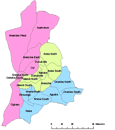
Dunukofia is a Local Government Area in Anambra State, South-East Nigeria. Towns that make up the local government are Ukpo, the headquarters; Ifitedunu, Dunukofia Umunnachi, Umudioka, Ukwulu and Nawgu. It shares boundaries with Awka North, Idemili North, Njikoka and Oyi Local Governments. The population is predominantly agrarian, but major in-roads have been made in commerce and education. Population density here is among the highest in all of Nigeria. There are general hospitals at Ifitedunu and Ukpo. There are also a dozen high schools for boys and girls. Dunukofia is among the most accessible local governments in Anambra State, with federal and state roads crossing it at different points. St Mary's High School Ifitedunu is categorised as one of the oldest post-primary schools in Anambra State. Schools The following secondary schools are in Dunukofia Local Government Area: * St. Mary's High School, Ifitedunu * Walter Eze Memorial Secondary School, Ukpo * Community Sec ... [...More Info...] [...Related Items...] OR: [Wikipedia] [Google] [Baidu] |
Anambra State
Anambra State is a Nigerian state, located in the southeastern region of the country. The state was created on August 27, 1991. Anambra state is bounded by Delta State to the west, Imo State to the south, Enugu State to the east and Kogi State to the north. According to the 2022 census report, there are over 9 million residents in the state. The state name was formed in 1976 from the former East Central State. The state is named after Omambala River, a river that runs through the state. Anambra is the Anglicized name of the Omambala. The State capital is Awka, a rapidly growing city that increased in population from approximately 700,000 to more than 6 million between 2006 and 2020. The city of Onitsha, a historic port city from the pre-colonial era, remains an important centre of commerce within the state. Nicknamed the "Light of the Nation", Anambra State is the eighth most populous state in the nation, although that has seriously been argued against as Onitsha, the ... [...More Info...] [...Related Items...] OR: [Wikipedia] [Google] [Baidu] |
Anambra
Anambra State is a Nigerian state, located in the southeastern region of the country. The state was created on August 27, 1991. Anambra state is bounded by Delta State to the west, Imo State to the south, Enugu State to the east and Kogi State to the north. According to the 2022 census report, there are over 9 million residents in the state. The state name was formed in 1976 from the former East Central State. The state is named after Omambala River, a river that runs through the state. Anambra is the Anglicized name of the Omambala. The State capital is Awka, a rapidly growing city that increased in population from approximately 700,000 to more than 6 million between 2006 and 2020. The city of Onitsha, a historic port city from the pre-colonial era, remains an important centre of commerce within the state. Nicknamed the "Light of the Nation", Anambra State is the eighth most populous state in the nation, although that has seriously been argued against as Onitsha, the sta ... [...More Info...] [...Related Items...] OR: [Wikipedia] [Google] [Baidu] |
Awkuzu
Awkuzu is a town in Oyi Local Government Area of Anambra state of Nigeria. Origin The story of Origin of Awkụzụ, Awkụzụ was one of the progenies of the fifth child of Eri his only daughter called Iguedo, who is also said to have borne the founders of Ogbunike, Awkụzụ, Umueri and Nando. Awkụzụ which is the colonial era of the name, "OKUZU" is presently located in Oyi Local Government Area of Anambra State and is bounded by Umunya and Nteje towns also in Oyi LGA, Ifitedunu, Ukpo and Ukwulu in Dunukofia LGA and Nando and Igbariam towns in today's Anambra East LGA, and Abba in Njikoka LGA. Division Awkụzụ is divided into three main parts: Ezi, Ifite and Ikenga sections according to seniority or birth order. Like most Eri-Awka towns of Igboland, each section is further divided into sub-villages. *Ezi has Iru-Ayika, Aka-Ezi, Igbu and Ozu . *Ifite section is made up of Amabo, Isioji, and Ifite-Umueri. *Ikenga has Ezinkwo, Nkwelle-Awkuzu, Umuobi ... [...More Info...] [...Related Items...] OR: [Wikipedia] [Google] [Baidu] |
Anambra River Bridge
Anambra State is a Nigerian state, located in the southeastern region of the country. The state was created on August 27, 1991. Anambra state is bounded by Delta State to the west, Imo State to the south, Enugu State to the east and Kogi State to the north. According to the 2022 census report, there are over 9 million residents in the state. The state name was formed in 1976 from the former East Central State. The state is named after Omambala River, a river that runs through the state. Anambra is the Anglicized name of the Omambala. The State capital is Awka, a rapidly growing city that increased in population from approximately 700,000 to more than 6 million between 2006 and 2020. The city of Onitsha, a historic port city from the pre-colonial era, remains an important centre of commerce within the state. Nicknamed the "Light of the Nation", Anambra State is the eighth most populous state in the nation, although that has seriously been argued against as Onitsha, the sta ... [...More Info...] [...Related Items...] OR: [Wikipedia] [Google] [Baidu] |
States Of Nigeria
Nigeria is a federation of 36 states and 1 federal capital territory. Each of the 36 states is a semi-autonomous political unit that shares powers with the federal government as enumerated under the Constitution of the Federal Republic of Nigeria. The Federal Capital Territory (FCT), is the capital territory of Nigeria, and it is in this territory that the capital city of Abuja is located. The FCT is not a state but is administered by elected officials who are supervised by the federal government. Each state is subdivided into local government areas (LGAs). There are 774 local governments in Nigeria. Under the constitution, the 36 states are co-equal but not supreme because sovereignty resides with the federal government. The constitution can be amended by the National Assembly, but each amendment must be ratified by two-thirds of the 36 states of the federation. Current states and the Federal Capital Territory Evolution of Nigerian states Government States of Nigeri ... [...More Info...] [...Related Items...] OR: [Wikipedia] [Google] [Baidu] |
West Africa Time
West Africa Time, or WAT, is a time zone used in west-central Africa. West Africa Time is one hour ahead of Coordinated Universal Time ( UTC+01:00), which aligns it with Central European Time (CET) during winter, and Western European Summer Time (WEST) / British Summer Time (BST) during summer. As most of this time zone is in the tropical region, there is little change in day length throughout the year and therefore daylight saving time is not observed. West Africa Time is the time zone for the following countries: * (as Central European Time) * * * * * * (western side only) * * * (as Central European Time) * * * * (as Central European Time) * Countries west of Benin (except Morocco and Western Sahara) are in the UTC±0 time zone. Civil time in most of those countries is defined with reference to Greenwich Mean Time (now an alias for UTC±0, rather than an independent reference). References See also * Central European Time, an equivalent time zone covering most ... [...More Info...] [...Related Items...] OR: [Wikipedia] [Google] [Baidu] |
Nigeria
Nigeria ( ), , ig, Naìjíríyà, yo, Nàìjíríà, pcm, Naijá , ff, Naajeeriya, kcg, Naijeriya officially the Federal Republic of Nigeria, is a country in West Africa. It is situated between the Sahel to the north and the Gulf of Guinea to the south in the Atlantic Ocean. It covers an area of , and with a population of over 225 million, it is the List of African countries by population, most populous country in Africa, and the List of countries and dependencies by population, world's sixth-most populous country. Nigeria borders Niger in Niger–Nigeria border, the north, Chad in Chad–Nigeria border, the northeast, Cameroon in Cameroon–Nigeria border, the east, and Benin in Benin–Nigeria border, the west. Nigeria is a Federation, federal republic comprising of States of Nigeria, 36 states and the Federal Capital Territory, Nigeria, Federal Capital Territory, where the capital, Abuja, is located. The List of Nigerian cities by population, largest city in Nigeria ... [...More Info...] [...Related Items...] OR: [Wikipedia] [Google] [Baidu] |
Google Maps
Google Maps is a web mapping platform and consumer application offered by Google. It offers satellite imagery, aerial photography, street maps, 360° interactive panorama, interactive panoramic views of streets (Google Street View, Street View), real-time traffic conditions, and route planner, route planning for traveling by foot, car, bike, air (in Software release life cycle#Beta, beta) and public transportation. , Google Maps was being used by over 1 billion people every month around the world. Google Maps began as a C++ desktop program developed by brothers Lars Rasmussen (software developer), Lars and Jens Eilstrup Rasmussen, Jens Rasmussen at Where 2 Technologies. In October 2004, the company was acquired by Google, which converted it into a web application. After additional acquisitions of a geospatial data visualization company and a real-time traffic analyzer, Google Maps was launched in February 2005. The service's Front and back ends, front end utilizes JavaScript, X ... [...More Info...] [...Related Items...] OR: [Wikipedia] [Google] [Baidu] |
Igbo People
The Igbo people ( , ; also spelled Ibo" and formerly also ''Iboe'', ''Ebo'', ''Eboe'', * * * ''Eboans'', ''Heebo''; natively ) are an ethnic group in Nigeria. They are primarily found in Abia, Anambra, Ebonyi, Enugu, and Imo States. A sizable Igbo population is also found in Delta and Rivers States. Large ethnic Igbo populations are found in Cameroon, Gabon, and Equatorial Guinea, as well as outside Africa. There has been much speculation about the origins of the Igbo people, which are largely unknown. Geographically, the Igbo homeland is divided into two unequal sections by the Niger River—an eastern (which is the larger of the two) and a western section. The Igbo people are one of the largest ethnic groups in Africa. The Igbo language is part of the Niger-Congo language family. Its regional dialects are somewhat mutually intelligible amidst the larger " Igboid" cluster. The Igbo homeland straddles the lower Niger River, east and south of the Edoid and Ido ... [...More Info...] [...Related Items...] OR: [Wikipedia] [Google] [Baidu] |
Script
Script may refer to: Writing systems * Script, a distinctive writing system, based on a repertoire of specific elements or symbols, or that repertoire * Script (styles of handwriting) ** Script typeface, a typeface with characteristics of handwriting * Script (Unicode), historical and modern scripts as organised in Unicode glyph encoding Arts, entertainment, and media * Script (comics), the dialogue for a comic book or comic strip * Script (video games), the narrative and text of a video game * Manuscript, any written document, often story-based and unpublished * Play (theatre), the dialogue and stage directions for a theatrical production * Rob Wagner's ''Script'', a defunct literary magazine edited by Rob Wagner * Screenplay, the dialogue, action and locations for film or television * Scripted sequence, a predefined series of events in a video game triggered by player location or actions * The Script, an Irish band ** ''The Script'' (album), their 2008 debut album ... [...More Info...] [...Related Items...] OR: [Wikipedia] [Google] [Baidu] |
Memories
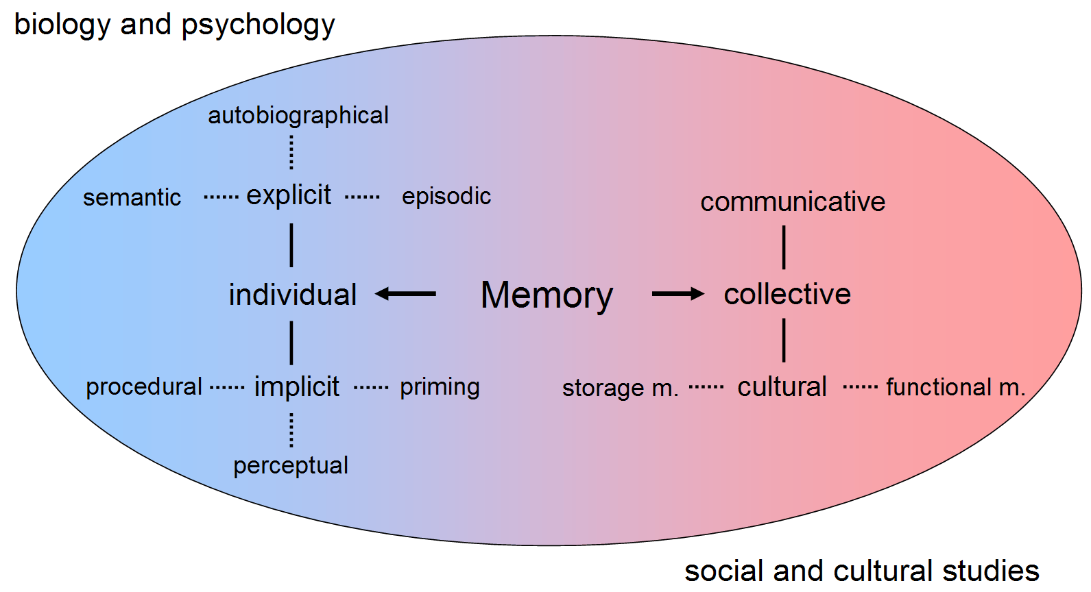
Memory is the faculty of the mind by which data or information is encoded, stored, and retrieved when needed. It is the retention of information over time for the purpose of influencing future action. If past events could not be remembered, it would be impossible for language, relationships, or personal identity to develop. Memory loss is usually described as forgetfulness or amnesia. Memory is often understood as an informational processing system with explicit and implicit functioning that is made up of a sensory processor, short-term (or working) memory, and long-term memory. This can be related to the neuron. The sensory processor allows information from the outside world to be sensed in the form of chemical and physical stimuli and attended to various levels of focus and intent. Working memory serves as an encoding and retrieval processor. Information in the form of stimuli is encoded in accordance with explicit or implicit functions by the working memory processor. Th ... [...More Info...] [...Related Items...] OR: [Wikipedia] [Google] [Baidu] |


