|
U7 (Berlin U-Bahn)
The U7 is a rail line on the Berlin U-Bahn. It runs completely underground for a length of through 40 stations and connects Spandau, via Neukölln, to Gropiusstadt and Rudow. The line was originally the south-eastern branch of the Nord-Süd-Bahn ( U6) that ran between the branching point at Belle-Alliance-Straße (Mehringdamm) and Grenzallee; however, in the 1960s, this stretch was separated from the rest of the line and extended at each end to form a new line. As of 2007, the U7 is Berlin's longest underground line, both in terms of absolute length and total travel time, and one of the longest (entire) subterranean lines in Europe. Route Starting in Rudow, at the junction of Gross-Ziethener Chaussee and Neuköllner Straße, the U7 runs northwest below the road Alt-Rudow, before bearing west in the Gropiusstadt area. Because the settlement and underground construction there were planned simultaneously, the U7 follows no roads until it reaches Britz-Süd station, where it runs ... [...More Info...] [...Related Items...] OR: [Wikipedia] [Google] [Baidu] |
Rapid Transit
Rapid transit or mass rapid transit (MRT), also known as heavy rail or metro, is a type of high-capacity public transport generally found in urban areas. A rapid transit system that primarily or traditionally runs below the surface may be called a subway, tube, or underground. Unlike buses or trams, rapid transit systems are railways (usually electric railway, electric) that operate on an exclusive right-of-way (transportation), right-of-way, which cannot be accessed by pedestrians or other vehicles, and which is often grade-separated in tunnels or on elevated railways. Modern services on rapid transit systems are provided on designated lines between rapid transit station, stations typically using electric multiple units on rail tracks, although some systems use guided rubber tires, magnetic levitation (''maglev''), or monorail. The stations typically have high platforms, without steps inside the trains, requiring custom-made trains in order to minimize gaps between train a ... [...More Info...] [...Related Items...] OR: [Wikipedia] [Google] [Baidu] |
Adenauerplatz (Berlin U-Bahn)
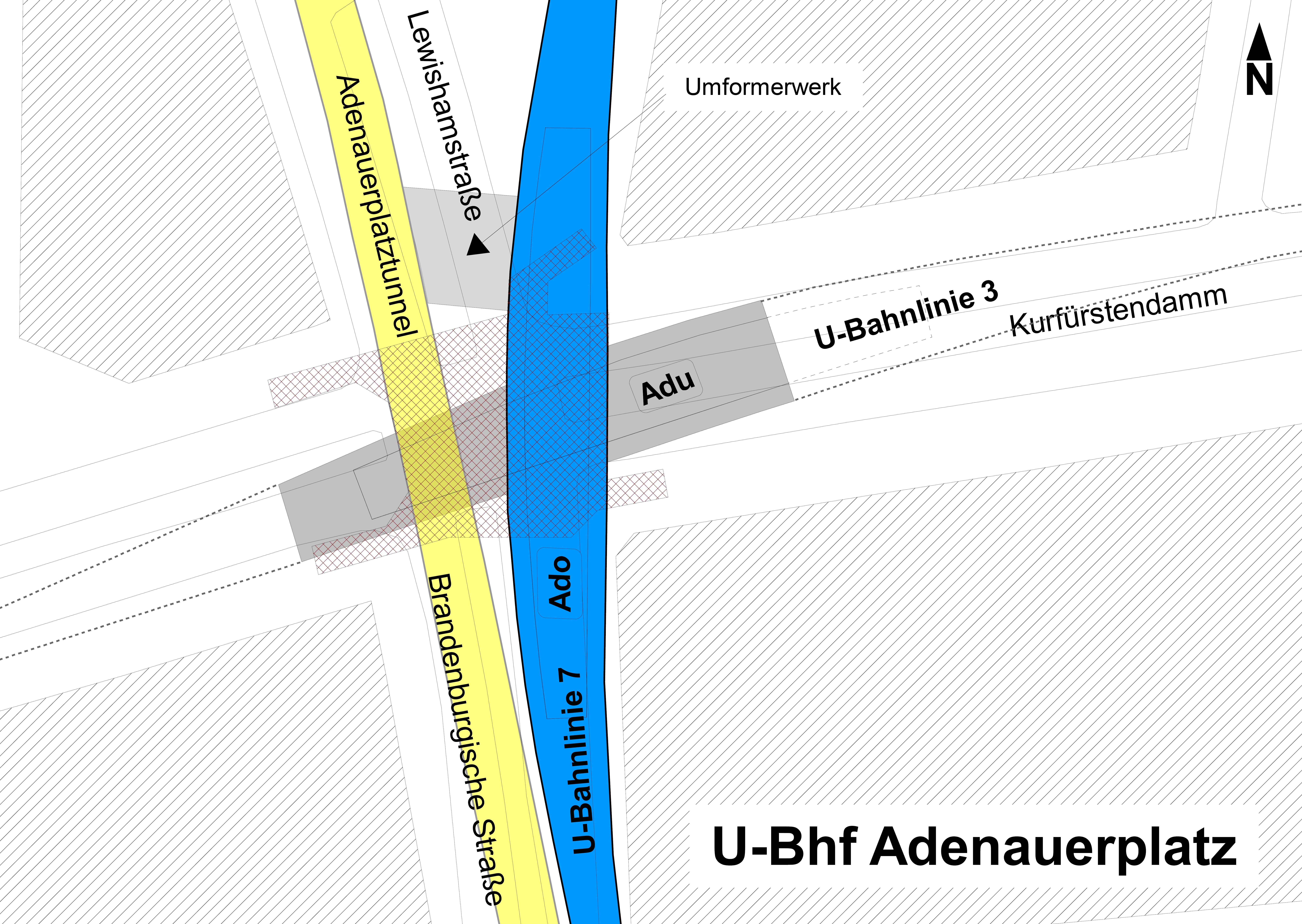
Adenauerplatz is a Berlin U-Bahn Station on the U7 line in the district of Charlottenburg, borough of Charlottenburg-Wilmersdorf. It was opened on 28 April 1978 after the north-west extension to Spandau, and is located on the Kurfürstendamm/Lewishamstraße intersection. As of 1 February 2019, a lift has been installed at the station, making it accessible. History The development of the area around the present Adenauerplatz was planned in 1913. The Kurfuerstendamm line (later U3, today U1) was to cross further westwards from the Uhlandstraße station, the present-day terminus, and terminate at Theodor-Heuss-Platz station. These plans were not initially put into action, meaning that the station was not built until the U7 line was extended in the 1970s. To accommodate the western extension of the U3, which was still in the planning stage, a second platform was built underneath the U7. In 2004, the underground station underwent complete renovation. The supports and the ceili ... [...More Info...] [...Related Items...] OR: [Wikipedia] [Google] [Baidu] |
Siemensstadt
Siemensstadt () is a locality (''Ortsteil'') of Berlin in the district (''Bezirk'') of Spandau. History The locality emerged when the company Siemens & Halske (S & H), one of the predecessors of today's Siemens, bought land in the area, in order to expand production of S & H and their subsidiary Siemens-Schuckertwerke (SSW) as well. On the initiative of Georg Wilhelm von Siemens S & H started to build new factories in 1899. Soon also residential buildings were erected. The locality was incorporated into Berlin on 1 October 1920 by the Greater Berlin Act. Geography Siemensstadt is situated in the eastern side of Spandau district. It borders with Spandau (locality), Haselhorst, Tegel (in Reinickendorf), Charlottenburg-Nord and Westend (both in Charlottenburg-Wilmersdorf). The Großsiedlung Siemensstadt is situated close to Siemensstadt but in Charlottenburg-Nord. Transport Siemensstadt is served by the Berliner U-Bahn line U7 at the stations of Pau ... [...More Info...] [...Related Items...] OR: [Wikipedia] [Google] [Baidu] |
Charlottenburg-Nord
Charlottenburg-Nord (, literally "Charlottenburg North") is a locality (''Ortsteil'') in the northern part of the Charlottenburg-Wilmersdorf borough of Berlin, Germany. It is chiefly composed of after-war housing estates, allotment gardens and commercial zones. The locality comprises the ''Großsiedlung Siemensstadt'', part of the Berlin Modernism Housing Estates UNESCO World Heritage Site, as well as Plötzensee Prison. Geography Charlottenburg-Nord is situated in the western suburbs of Berlin, beyond the Ringbahn line of the Berlin S-Bahn. In the north the Berlin-Spandau Ship Canal forms the border with Reinickendorf and Tegel, a bridge leading right to the southern entrance of former Berlin Tegel Airport. It further borders with Siemensstadt (part of the Spandau borough) in the west. In the east and south the Berlin-Spandau Ship Canal and the Westhafen Canal mark the border with the inner city localities of Wedding and Moabit (both part of the Mitte borough) and Charlottenburg. ... [...More Info...] [...Related Items...] OR: [Wikipedia] [Google] [Baidu] |
Charlottenburg
Charlottenburg () is a Boroughs and localities of Berlin, locality of Berlin within the borough of Charlottenburg-Wilmersdorf. Established as a German town law, town in 1705 and named after Sophia Charlotte of Hanover, Queen consort of Kingdom of Prussia, Prussia, it is best known for Charlottenburg Palace, the largest surviving royal palace in Berlin, and the adjacent museums. Charlottenburg was an independent city to the west of Berlin until 1920 when it was incorporated into "Greater Berlin Act, Groß-Berlin" (Greater Berlin) and transformed into a borough. In the course of Berlin's 2001 administrative reform it was merged with the former borough of Wilmersdorf becoming a part of a new borough called Charlottenburg-Wilmersdorf. Later, in 2004, the new borough's districts were rearranged, dividing the former borough of Charlottenburg into the localities of Charlottenburg proper, Westend (Berlin), Westend and Charlottenburg-Nord. Geography Charlottenburg is located in Berlin ... [...More Info...] [...Related Items...] OR: [Wikipedia] [Google] [Baidu] |
Wilmersdorf
Wilmersdorf (), an inner-city locality of Berlin, lies south-west of the central city. Formerly a borough by itself, Wilmersdorf became part of the new borough of Charlottenburg-Wilmersdorf in Berlin's 2001 administrative reform. History The village near Berlin was first mentioned in 1293 as ''Wilmerstorff'', probably founded in the course of the German ''Ostsiedlung'' under the Ascanian margraves of Brandenburg. From the 1850s on ''Deutsch-Wilmersdorf'' was developed as a densely settled, affluent residential area, which in 1920 became a part of Greater Berlin. The former borough of Wilmersdorf included the localities of Halensee, Schmargendorf and Grunewald. During the era of the Weimar Republic Wilmersdorf was a popular residential area for artists and intellectuals. In 1923 the foundation stone for the first mosque in Germany was laid on the initiative of some islamic students in Wilmersdorf. It was completed in 1925. The so called Wilmersdorfer Moschee (''Mosque of Wilmer ... [...More Info...] [...Related Items...] OR: [Wikipedia] [Google] [Baidu] |
Schöneberg
Schöneberg () is a locality of Berlin, Germany. Until Berlin's 2001 administrative reform it was a separate borough including the locality of Friedenau. Together with the former borough of Tempelhof it is now part of the new borough of Tempelhof-Schöneberg. History The village was first documented in a 1264 deed issued by Margrave Otto III of Brandenburg. In 1751, Bohemian weavers founded Neu-Schöneberg also known as Böhmisch-Schöneberg along northern Hauptstraße. During the Seven Years' War on 7 October 1760 Schöneberg and its village church were completely destroyed by a fire due to the joint attack on Berlin by Habsburg and Russian troops. Both Alt-Schöneberg and Neu-Schöneberg were in an area developed in the course of industrialization and incorporated in a street network laid out in the Hobrecht-Plan in an area that came to be known architecturally as the Wilhelmine Ring. The two villages were not combined as one entity until 1874 and received town privileg ... [...More Info...] [...Related Items...] OR: [Wikipedia] [Google] [Baidu] |
Kreuzberg
Kreuzberg () is a district of Berlin, Germany. It is part of the Friedrichshain-Kreuzberg borough located south of Mitte. During the Cold War era, it was one of the poorest areas of West Berlin, but since German reunification in 1990 it has become more gentrified and known for its arts scene. The borough is known for its large percentage of immigrants and descendants of immigrants, many of whom are of Turkish ancestry. As of 2006, 31.6% of Kreuzberg's inhabitants did not have German citizenship. Kreuzberg is noted for its diverse cultural life and experimental alternative lifestyles, and is an attractive area for many, however, some parts of the district are still characterized by higher levels of unemployment. The counterculture tradition of Kreuzberg led to a plurality of votes for the Green Party, which is unique among all Berlin boroughs. Geography Layout Kreuzberg is bounded by the river Spree in the east. The Landwehrkanal flows through Kreuzberg from east to ... [...More Info...] [...Related Items...] OR: [Wikipedia] [Google] [Baidu] |
Britz
Britz () is a German locality (''Ortsteil'') within the Berlin borough (''Bezirk'') of Neukölln. History The village of ''Britzig'' was first mentioned in 1273. It was incorporated by the 1920 Greater Berlin Act. It is known for being the site of the ''Hufeisensiedlung'' ("Horseshoe Estate"), part of the UNESCO Berlin Modernism Housing Estates World Heritage Site since 2008. Public transport Britz is served by the traveling North / South from and to the terminus at . |
Rathaus Spandau (Berlin U-Bahn)
Rathaus Spandau (Spandau Town Hall) is one of the western termini of Berlin U-Bahn line U7 (the other one being Rudow). It was opened on 1 October 1984 with the line's extension from Rohrdamm to Rathaus Spandau. The station takes its name from the nearby Rathaus Spandau, the historic city hall of Spandau. Close to the U-Bahn station Rathaus Spandau is the Berlin-Spandau station of the Berlin S-Bahn line S5 and the Deutsche Bahn for regional and intercity transport. The next station on the U7 line is Altstadt Spandau. The station was built in a box under a cover in order to minimise the disturbance of surface traffic. With its two island platforms, the station, which was designed by Rainer G. Rümmler, has almost monumental dimensions. It has a big hall with high ceilings, much light and 64 lamps, columns with black granite and a parquet floor like floor. The southern end of its platforms are spanned by a gallery for the movement of passengers to the surface and from which the ... [...More Info...] [...Related Items...] OR: [Wikipedia] [Google] [Baidu] |
Spandau (locality)
Spandau () is a locality (''Ortsteil'') of Berlin in the homonymous borough (''Bezirk'') of Spandau. The historic city is situated, for the most part, on the western banks of the Havel river. As of 2020 the estimated population of Spandau was 39,653. Geography Position The locality is situated in the middle of its borough. It borders Wilhelmstadt in the south, Staaken and Falkenhagener Feld in the west, Hakenfelde in the north as well as Haselhorst, Siemensstadt and Westend (in Charlottenburg-Wilmersdorf district) in the east. Subdivision Spandau proper is subdivided into four historic neighbourhoods (''Ortslagen''): #Altstadt Spandau (Old Town) # Neustadt Spandau (New Town, the northern expansion) # Stresow (east of the Havel) # Kolk-Spandau History The city was founded at the confluence of the rivers Spree and Havel. The settlement of the area can be traced back to the 6th century when the eastern territories of the Elbe river were populated by several Slavic tribes. Th ... [...More Info...] [...Related Items...] OR: [Wikipedia] [Google] [Baidu] |
Spandau Citadel
The Spandau Citadel (german: Zitadelle Spandau) is a fortress in Berlin, Germany, one of the best-preserved Renaissance military structures of Europe. Built from 1559–94 atop a medieval fort on an island near the meeting of the Havel and the Spree, it was designed to protect the town of Spandau, which is now part of Berlin. In recent years it has been used as a museum and has become a popular tourist spot. Furthermore, the inner courtyard of the Citadel has served as an open air concert venue in the summertime since 2005. History In 1157, Albert the Bear built a frontier fortress at this site, and by the middle of the 15th century, the site was the Margrave of Brandenburg seat of government. By 1560, Joachim II Hector, Elector of Brandenburg engaged Christoph Römer to build an Italian style fortress, incorporating the older castle, Palas, and Julius Tower. In 1562, Römer was replaced by Francesco Chiaramella de Gandino. In 1578 Rochus Graf zu Lynar took over. In 158 ... [...More Info...] [...Related Items...] OR: [Wikipedia] [Google] [Baidu] |


