|
Turkestan Province
Turkestan Province ( prs, ولایت ترکستان) was a province in Afghanistan. It was located in northern Afghanistan in the region still known as Afghan Turkestan. In 1890, Qataghan-Badakhshan Province was separated from Turkestan Province. It is present in an administrative map of 1929, but was abolished by the time of the 1946 population census. Political administration In the 19th century, Afghan Turkestan was governed by a governor (''hakim'') appointed by the Amir.Christine NoelleState and tribe in nineteenth-century Afghanistan: the reign of Amir Dost Muhammad Khan (1826-1863) Routledge, 1997. pp. 101 Below is a list of governors of Afghan Turkestan. *Sardar Mohammad Akram Khan - 1850 - 1852 *Sardar Mohammad Afzal Khan - 1852 - 1864 *Sardar Fath Mohammad Khan - 1864 - 1865 *Fayz Mohammad Khan - 1865 - 1867 * Naib Muhammad Alam Khan - 1868 - 1876 *Shahghasi Sherdil Loynab Khan - 1876 -1878 Subdivisions In 1886 the administrative divisions of Afghan Turkestan were ... [...More Info...] [...Related Items...] OR: [Wikipedia] [Google] [Baidu] |
Afghanistan
Afghanistan, officially the Islamic Emirate of Afghanistan,; prs, امارت اسلامی افغانستان is a landlocked country located at the crossroads of Central Asia and South Asia. Referred to as the Heart of Asia, it is bordered by Pakistan to the Durand Line, east and south, Iran to the Afghanistan–Iran border, west, Turkmenistan to the Afghanistan–Turkmenistan border, northwest, Uzbekistan to the Afghanistan–Uzbekistan border, north, Tajikistan to the Afghanistan–Tajikistan border, northeast, and China to the Afghanistan–China border, northeast and east. Occupying of land, the country is predominantly mountainous with plains Afghan Turkestan, in the north and Sistan Basin, the southwest, which are separated by the Hindu Kush mountain range. , Demographics of Afghanistan, its population is 40.2 million (officially estimated to be 32.9 million), composed mostly of ethnic Pashtuns, Tajiks, Hazaras, and Uzbeks. Kabul is the country's largest city and ser ... [...More Info...] [...Related Items...] OR: [Wikipedia] [Google] [Baidu] |
Kholm, Afghanistan
Kholm or Khulm (Dari/Pashto: خلم), formerly known as Tashqurghan (Dari/Uzbek: تاشقرغان), is a town in Balkh Province of northern Afghanistan, 60 km east of Mazar-i-Sharif one-third of the way to Kunduz. Kholm is an ancient town located on the fertile, inland delta fan of the Khulm River (Darya-i- Tashqurghan). As such, it is an agriculturally rich locale and densely populated. It is famous for its covered market, and is a centre for trading in sheep and wood. The town was once part of Samangan Province, now in the Khulm District of Balkh. Etymology The original name Tashqurghan (also romanized ''Tashkorghan'') is Uzbeki word for "stone mausoleum/kurgan". The town's name was changed to Kholm (also romanized ''Khulm'') during the Pashtunisation of northern Afghanistan by the central government headed by Minister of the Interior, Wazir Mohammad Gul Khan. History and background For many centuries Afghanistan was located on the old serais (along the Silk Road) ... [...More Info...] [...Related Items...] OR: [Wikipedia] [Google] [Baidu] |
Sar-e Pol Province
Sar-e Pol, also spelled Sari Pul (Dari/Pashto: ), is one of the thirty-four provinces of Afghanistan, located in the north of the country. It borders Ghor and Bamyan to the south, Samangan to the east, Balkh and Jowzjan to the north, and Faryab to the west. The province is divided into 7 districts and contains 896 villages. It has a population of about 632,000, which is multi-ethnic and mostly a tribal society. The province was created in 1988, with the support of northern Afghan politician Sayed Nasim Mihanparast. The city of Sar-e Pol serves as the provincial capital. In 2021, the Taliban gained control of the province during the 2021 Taliban offensive. History Between the early 16th century and the mid-18th century, the territory was ruled by the Khanate of Bukhara. It was given to Ahmad Shah Durrani by Murad Beg of Bukhara after a treaty was signed in or about 1750, and became part of the Durrani Empire. It was ruled by the Durranis followed by the Barakzai dynasty. The a ... [...More Info...] [...Related Items...] OR: [Wikipedia] [Google] [Baidu] |
Sancharak District
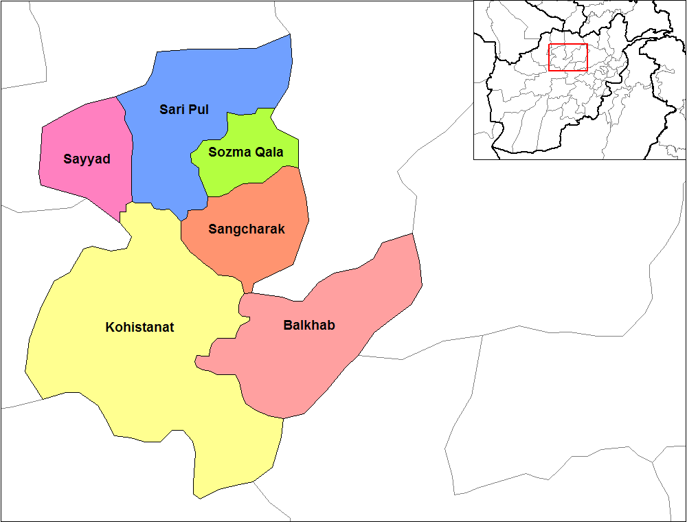
Sancharak District ( fa, سانچارک) or Sangcharak is a district of Sar-e Pol Province, Afghanistan. Its center is the city of Tukzar or Tokzar. Sancharak district borders Balkh Province in the east. Sancharak District's area is 1089 square kilometres.Ministry of Rural Rehabilitation and Development of Afghanistan, NABDP, Development Programme of Sancharak District Population The population of Sancharak district is 87,670 people as of 2010. About 44,287 and 43,383 |
Kahmard
, native_name_lang = prs , settlement_type = Town , image_skyline = , imagesize = , image_alt = , image_caption = , image_flag = , flag_alt = , image_seal = , seal_alt = , image_shield = , shield_alt = , etymology = , nickname = , motto = , image_map = , map_alt = , map_caption = , pushpin_map = Afghanistan , pushpin_map_alt = , pushpin_map_caption = Location in Afghanistan , pushpin_label_position = bottom , coordinates = , coor_pinpoint = , coordinates_footnotes = , subdivision_type = Country , subdivision_name = Afghanistan , subdivision_type1 = Province , subdivision_name1 = Bamyan Province , subdivision_type2 = District , subdivision_name2 = Ka ... [...More Info...] [...Related Items...] OR: [Wikipedia] [Google] [Baidu] |
Sayghan District
Saighan District (also Sayghan District) ( prs, سیغان) is part of Bamyan Province, Afghanistan. it has a population of 23,215.Bamyan PDP Provincial profile . National Area Based Development Program, Ministry of Rural Rehabilitation and Development, Islamic Republic of Afghanistan (2007), citing as a source: "CSO/UNFPA Socio Economic and Demographic Profile" (2003). Archived fro the original on 2 December 2010. Retrieved 25 November 2008. It was created in 2005 from part of [...More Info...] [...Related Items...] OR: [Wikipedia] [Google] [Baidu] |
Darah Sof District
} , native_name_lang = prs , settlement_type = District , image_skyline = , imagesize = , image_caption = , image_map = , mapsize = , map_caption = , pushpin_map = Afghanistan , pushpin_mapsize = 300 , pushpin_label_position = bottom , pushpin_map_caption = Location in Afghanistan , coordinates = , subdivision_type = Country , subdivision_name = , subdivision_type1 = Province , subdivision_name1 = Samangan Province , subdivision_type2 = No. of Community Development Councils , subdivision_name2 = , subdivision_type3 = , subdivision_name3 = , unit_pref = Metric , seat_type = Capital , seat = , leader_title = , leader_name = , established_title = , established_date = , area_total_km2 = , population_as_of =2003 , population_footnotes ... [...More Info...] [...Related Items...] OR: [Wikipedia] [Google] [Baidu] |
Aybak, Samangan
Aybak (Aibak or Haibak; previously Eukratidia ( grc, Εὐκρατιδία); historically known as Samangan) is a provincial town, medieval caravan stop, and the headquarters of the Samangan Province in the district of the same name in the northern part of Afghanistan. As an ancient town and major Buddhist centre during the 4th and 5th centuries under the then Kushan rulers, it has the ruins of that period at a place known now as Takht-i-rustam, which is located on a hill above the town. Due to its location, Haibak has been influenced by Buddhist, Islamic and Turkic and Persian peoples. In the past, it was significant because of its position on the main line of communication between Kabul and Afghan Turkestan. In 2021, the Taliban gained control of the city during the 2021 Taliban offensive. History The earliest known history is linked to the identification of the place by Ptolemy as the place of the Varni or Uarni and the fortified city of Samangan on the banks of the Khul ... [...More Info...] [...Related Items...] OR: [Wikipedia] [Google] [Baidu] |
Andkhoy (city)
Andkhoy ( prs, اندخوی; ps, اندخوی ولسوالۍ) is a city in the northern part of Afghanistan, which has a population of about 47,857 people. They include all the major ethnic groups of the country. The city serves as the capital of Andkhoy District in the Faryab Province. It is around of driving distance southwest from the Aqina–Imamnazar border crossing between Afghanistan and Turkmenistan. There is also a rail station in the city, which was recently opened for import and export purposes with neighboring Turkmenistan. The Sheberghan Airfield in neighboring Jowzjan Province is the closest airport to Andkhoy. Ruwe Arjans The town founded by "The Ruwe Arjans", stands between the northern spurs of the Paropamise and the Oxus; it is 100 km. due west of Balkh, on the edge of the Turkmen desert. The area was an independent Khanate, ruled by members of the Afshar tribe from 1747 to 1880. In 1847, the city was sacked by Yar Mohammad Khan, the ruler of Herat, ... [...More Info...] [...Related Items...] OR: [Wikipedia] [Google] [Baidu] |
Sheberghan
Sheberghān or Shaburghān ( Uzbek, Pashto, fa, شبرغان), also spelled ''Shebirghan'' and ''Shibarghan'', is the capital city of the Jowzjan Province in northern Afghanistan. The city of Sheberghan has a population of 175,599. It has four districts and a total land area of 7,335 hectares. The total number of dwellings in Sheberghān is 19,511. In 2021, the Taliban gained control of the city during the 2021 Taliban offensive. Location Sheberghān is located along the Sari Pul River banks, about west of Mazar-i-Sharif on the national primary ring road that connects Kabul, Puli Khumri, Mazar-i-Sharif, Sheberghān, Maymana, Herat, Kandahar, Ghazni, and Maidan Shar. Sheberghān airport is situated between Sheberghān and Aqcha. Etymology The city's name is a corruption of its classical Persian name, Shaporgân, meaning "ingShapur's town". Shapur was the name of two Sasanian kings, both of whom built a great number of cities. However, Shapur I was the governor of the east ... [...More Info...] [...Related Items...] OR: [Wikipedia] [Google] [Baidu] |
Dawlat Abad District
Dawlat Abad is a district in Faryab Province, Afghanistan. The population of the district was estimated 95,800 in 2009. The centre of the district is the town of Dawlat Abad (population 5000), located at , 447 m altitude, on the route from Sheberghan to Maimana. At one time it had a bazaar with 180 shops and caravanserais. Dawlat Abad is a centre for carpet A carpet is a textile floor covering typically consisting of an upper layer of pile attached to a backing. The pile was traditionally made from wool, but since the 20th century synthetic fibers such as polypropylene, nylon, or polyester hav ...-weaving in northern Afghanistan. From 24 April and 7 May 2014, flash flooding from heavy rainfall resulted in the destruction of public facilities, roads, and agricultural land. Within the villages of Khair Abad, Qoraish, Sheikh ha, Popalzayi, Qozibay Qala, Jare Bagh, and Takht Eshan, 486 families were affected, 5 people killed, 250 livestock killed and 5,000 Jeribs of agricu ... [...More Info...] [...Related Items...] OR: [Wikipedia] [Google] [Baidu] |
Afghan Turkestan
Afghan Turkestan, also known as Southern Turkestan,; tk, گوناورتا ترکستان, Günorta Türkistan, italics=no; uz, جنوبی ترکستان, Janubiy Turkiston is a region in northern Afghanistan, on the border with the former Soviet republics of Turkmenistan, Uzbekistan and Tajikistan. In the 19th century, there was a province in Afghanistan named Turkestan with Mazari Sharif as provincial capital. The province incorporated the territories of the present-day provinces of Balkh, Kunduz, Jowzjan, Sar-e Pol, and Faryab. In 1890, Qataghan-Badakhshan Province was separated from Turkestan Province. It was later abolished by Emir Abdur Rahman. The whole territory of Afghan Turkestan, from the junction of the Kokcha river with the Amu Darya on the north-east to the province of Herat on the south-west, was some in length, with an average width from the Russian frontier to the Hindu Kush of . It thus comprised about or roughly two-ninths of the former Kingdom of Afghani ... [...More Info...] [...Related Items...] OR: [Wikipedia] [Google] [Baidu] |


