|
Tullochgorm
Tullochgorm is an old township parish which lies one mile south of Minard in the county of Argyll and Bute in Western Scotland and today comprises only six inhabited cottages. The parish originally supported more scattered hillside crofts; these gradually fell into disuse during the Highland Clearances and the closure of the timber mill on the Minard Estate at the turn of the 19th century. Some of the original dwellings, in ruins, were absorbed by forestation by the Forestry Commission The Forestry Commission is a non-ministerial government department responsible for the management of publicly owned forests and the regulation of both public and private forestry in England. The Forestry Commission was previously also respon .... Smithy Cottage is the oldest remaining inhabited dwelling. During its time it served as the blacksmith's house (the old blacksmiths forge remains as a ruin), the village school, and as a post office. References Geography of Argyll and Bute ... [...More Info...] [...Related Items...] OR: [Wikipedia] [Google] [Baidu] |
Scotland
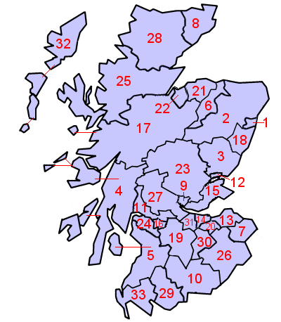
Scotland (, ) is a country that is part of the United Kingdom. Covering the northern third of the island of Great Britain, mainland Scotland has a border with England to the southeast and is otherwise surrounded by the Atlantic Ocean to the north and west, the North Sea to the northeast and east, and the Irish Sea to the south. It also contains more than 790 islands, principally in the archipelagos of the Hebrides and the Northern Isles. Most of the population, including the capital Edinburgh, is concentrated in the Central Belt—the plain between the Scottish Highlands and the Southern Uplands—in the Scottish Lowlands. Scotland is divided into 32 administrative subdivisions or local authorities, known as council areas. Glasgow City is the largest council area in terms of population, with Highland being the largest in terms of area. Limited self-governing power, covering matters such as education, social services and roads and transportation, is devolved from the Scott ... [...More Info...] [...Related Items...] OR: [Wikipedia] [Google] [Baidu] |
Lieutenancy Areas Of Scotland
The lieutenancy areas of Scotland are the areas used for the ceremonial lord-lieutenants, the monarch's representatives, in Scotland. The lord-lieutenants' titles chosen by the monarch and his legal advisers are mainly based on placenames of the traditional counties of Scotland. In 1794 permanent lieutenancies were established by Royal Warrant. By the Militia Act 1797 (37 Geo.3, C.103), the lieutenants appointed "for the Counties, Stewartries, Cities, and Places" were given powers to raise and command County Militia Units. While in their lieutenancies, lord lieutenants are among the few individuals in Scotland officially permitted to fly a banner of the Royal Arms of Scotland, the "Lion Rampant" as it is more commonly known. Lieutenancy areas are different from the current local government council areas and their committee areas. They also differ from other subdivisions of Scotland including sheriffdoms and former regions and districts. The Lord Provosts of Aberdeen, Dunde ... [...More Info...] [...Related Items...] OR: [Wikipedia] [Google] [Baidu] |
Argyll And Bute
Argyll and Bute ( sco, Argyll an Buit; gd, Earra-Ghàidheal agus Bòd, ) is one of 32 unitary authority council areas in Scotland and a lieutenancy area. The current lord-lieutenant for Argyll and Bute is Jane Margaret MacLeod (14 July 2020). The administrative centre for the council area is in Lochgilphead at Kilmory Castle, a 19th-century Gothic Revival building and estate. The current council leader is Robin Currie, a councillor for Kintyre and the Islands. Description Argyll and Bute covers the second-largest administrative area of any Scottish council. The council area adjoins those of Highland, Perth and Kinross, Stirling and West Dunbartonshire. Its border runs through Loch Lomond. The present council area was created in 1996, when it was carved out of the Strathclyde region, which was a two-tier local government region of 19 districts, created in 1975. Argyll and Bute merged the existing Argyll and Bute district and one ward of the Dumbarton district. The Dumbart ... [...More Info...] [...Related Items...] OR: [Wikipedia] [Google] [Baidu] |
Forestry Commission
The Forestry Commission is a non-ministerial government department responsible for the management of publicly owned forests and the regulation of both public and private forestry in England. The Forestry Commission was previously also responsible for Forestry in Wales and Scotland. However, on 1 April 2013, Forestry Commission Wales merged with other agencies to become Natural Resources Wales, whilst two new bodies (Forestry and Land Scotland and Scottish Forestry) were established in Scotland on 1 April 2019. The Forestry Commission was established in 1919 to expand Britain's forests and woodland, which had been severely depleted during the First World War. The Commission bought large amounts of agricultural land on behalf of the state, eventually becoming the largest manager of land in Britain. Today, the Forestry Commission is divided into three divisions: Forestry England, Forestry Commission and Forest Research. Over time the purpose of the Commission broadened to includ ... [...More Info...] [...Related Items...] OR: [Wikipedia] [Google] [Baidu] |


