|
Tsuno, Miyazaki
is a town located in Koyu District, Miyazaki Prefecture, Japan. The town has an estimated population of 9,996 and the density of 98.0 persons per km². The total area is 102.11 km². Geography Neighbouring municipalities * Miyazaki Prefecture ** Hyuga ** Kawaminami ** Kijo Transportation Railway * JR Kyushu - Nippō Main Line ** Higashi-Tsuno - Tsuno Highways * Higashikyushu Expressway * Japan National Route 10 240px, Route 10, Ōita 240px, Route 10, Fukuoka, Kanda is a Japanese highway on the island of Kyushu. It originates at the intersection with Route 2 in Kitakyushu, Furoka and passes through the prefectural capitals of Ōita and Miyazaki, ... References External links *Tsuno official website Towns in Miyazaki Prefecture {{Miyazaki-geo-stub ... [...More Info...] [...Related Items...] OR: [Wikipedia] [Google] [Baidu] |
Miyazaki Prefecture
is a prefecture of Japan located on the island of Kyūshū. Miyazaki Prefecture has a population of 1,073,054 (1 June 2019) and has a geographic area of 7,735 km2 (2,986 sq mi). Miyazaki Prefecture borders Ōita Prefecture to the north, Kumamoto Prefecture to the northwest, and Kagoshima Prefecture to the southwest. Miyazaki is the capital and largest city of Miyazaki Prefecture, with other major cities including Miyakonojō, Nobeoka, and Hyūga. Miyazaki Prefecture is located in southeastern Kyūshū on Japan's Pacific coast, with its coastline extending from Nobeoka near the entrance to the Bungo Channel to Shibushi Bay in Kushima. History Historically, after the Meiji Restoration, Hyūga Province was renamed Miyazaki Prefecture. In Japan, Miyazaki Prefecture was first created in 1873 when Mimitsu Prefecture was merged with parts of Miyakonojō Prefecture. The first Miyazaki existed only until 1876 when it was merged (back) into Kagoshima Prefecture. Under publ ... [...More Info...] [...Related Items...] OR: [Wikipedia] [Google] [Baidu] |
Population
Population typically refers to the number of people in a single area, whether it be a city or town, region, country, continent, or the world. Governments typically quantify the size of the resident population within their jurisdiction using a census, a process of collecting, analysing, compiling, and publishing data regarding a population. Perspectives of various disciplines Social sciences In sociology and population geography, population refers to a group of human beings with some predefined criterion in common, such as location, race, ethnicity, nationality, or religion. Demography is a social science which entails the statistical study of populations. Ecology In ecology, a population is a group of organisms of the same species who inhabit the same particular geographical area and are capable of interbreeding. The area of a sexual population is the area where inter-breeding is possible between any pair within the area and more probable than cross-breeding with in ... [...More Info...] [...Related Items...] OR: [Wikipedia] [Google] [Baidu] |
Higashikyushu Expressway
The is one of the expressways of Japan from Kitakyūshū (and the bridge to Honshū) to east of Kagoshima linking with the Kyushu Expressway. It runs north to south, through the prefectures of Fukuoka, Oita, Miyazaki and the Kagoshima prefectures. The freeway runs entirely on the island of Kyūshū. The total length is 500 km. Overview The first section of the expressway was opened to traffic in 1999. As of March 2009 the expressway incomplete in many areas. The next section is scheduled to open in 2010 ( Soo Yagorō Interchange to Sueyoshi Takarabe Interchange). After this, Most of the incomplete areas will be built according to the New Direct Control System, whereby the burden for construction costs will be shared by the national and local governments and no tolls will be collected. Currently the section between Saiki Interchange and Nobeoka Minami Interchange, and Kanoya Kushira Junction and Sueyoshi Takarabe Interchange operates according to this principle. The ... [...More Info...] [...Related Items...] OR: [Wikipedia] [Google] [Baidu] |
Tsuno Station
is a passenger railway station in the town of Tsuno, Miyazaki, Japan. It is operated by JR Kyushu and is on the Nippō Main Line. Lines The station is served by the Nippō Main Line and is located 298.7 km from the starting point of the line at . Layout The station consists of an island platform serving two tracks at grade with a siding. The station building is wooden structure built in traditional Japanese style and remodelled in 2017. It houses a staffed ticket window, a waiting area, the office of the local tourism association and a community space which features a diorama maintained by local railway enthusiasts. Access to the island platform is by means of a footbridge. A bike shed is provided at the station forecourt. JR Kyushu had planned to cease staffing the station. To maintain service to residents, the Tsuno town authorities took over the management of the ticket window as a kan'i itaku agent on 1 April 2015. Platforms History In 1913, the had open ... [...More Info...] [...Related Items...] OR: [Wikipedia] [Google] [Baidu] |
Higashi-Tsuno Station
is a passenger railway station located in the town of Tsuno, Miyazaki, Japan. It is operated by JR Kyushu and is on the Nippō Main Line. Lines The station is served by the Nippō Main Line and is located 294.1 km from the starting point of the line at . Only local trains stop at this station. Layout The station consists of two side platforms serving two tracks at grade. There is no station building, only a simple shed has been provided on platform 1 as a waiting room for passengers. A bike shed is provided at the station forecourt which also has ample space for parking. Access to the opposite side platform is by means of a footbridge; however, this platform is used as a siding and in normal operations all trains use platform 1. Platforms History Japanese National Railways (JNR) opened the station on 21 August 1952 as an additional station on the existing track of the Nippō Main Line. Baggage handling was suspended in 1974 and the station became unattended at ... [...More Info...] [...Related Items...] OR: [Wikipedia] [Google] [Baidu] |
Nippō Main Line
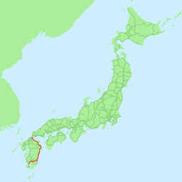
The is a railway line in Kyushu, in southern Japan, operated by Kyushu Railway Company (JR Kyushu). The line connects Kokura Station in Kitakyushu, Fukuoka, and Kagoshima Station in Kagoshima via the east coast of Kyushu, passing through the prefectural capitals of Ōita and Miyazaki. A number of Limited Express trains operate along the route, including Limited Express Sonic trains between Hakata and Oita. Stations :●: Stops :▲: Rapid service connecting to Hitahikosan Line non-stop, :|: Non-stop :Liner services: ''Sawayaka Liner'', ''Home Liner'' Though Kagoshima is the southern terminus for the line, some trains continue via the Kagoshima Main Line to the adjacent Kagoshima-Chūō station. History The Kyushu Railway Co. opened the 6 km Kokura - Jono section in 1895, and the Hōshū Railway Co. opened the 46 km Yukuhashi - Buzen Nagasu section in 1897. The former company acquired the latter in 1901, and was nationalised in 1907. The lines were connected ... [...More Info...] [...Related Items...] OR: [Wikipedia] [Google] [Baidu] |
JR Kyushu
The , also referred to as , is one of the seven constituent companies of Japan Railways Group (JR Group). It operates intercity rail services within Kyushu, Japan and the JR Kyushu Jet Ferry Beetle hydrofoil service across the Tsushima Strait between Fukuoka and Busan, South Korea. It also operates hotels, restaurants, and drugstores across its service region. JR Kyushu's headquarters are in Hakata-ku, Fukuoka. ." Kyushu Railway Company. Retrieved on March 27, 2010. History When was divided in 1987, Kyushu Railway Company inherited its assets and operations on the island of |
Kijō, Miyazaki
is a town located in Koyu District, Miyazaki Prefecture, Japan. , the town had an estimated population of 5,008 and the density Density (volumetric mass density or specific mass) is the substance's mass per unit of volume. The symbol most often used for density is ''ρ'' (the lower case Greek letter rho), although the Latin letter ''D'' can also be used. Mathematical ... of 34.3 persons per km². The total area is 145.96 km². References External links *Kijō official website Towns in Miyazaki Prefecture {{Miyazaki-geo-stub ... [...More Info...] [...Related Items...] OR: [Wikipedia] [Google] [Baidu] |
Kawaminami, Miyazaki
is a town located in Koyu District, Miyazaki Prefecture, Japan. As of October 1, 2019, the town has an estimated population of 15,372 and the density of 171 persons per km². The total area is 90.12 km². Transportation Railway * JR Kyushu - Nippō Main Line ** Kawaminami Station Highways * Higashikyushu Expressway The is one of the expressways of Japan from Kitakyūshū (and the bridge to Honshū) to east of Kagoshima linking with the Kyushu Expressway. It runs north to south, through the prefectures of Fukuoka, Oita, Miyazaki and the Kagoshima prefec ... * Japan National Route 10 References External links *Kawaminami official website Towns in Miyazaki Prefecture {{Miyazaki-geo-stub ... [...More Info...] [...Related Items...] OR: [Wikipedia] [Google] [Baidu] |
Hyūga, Miyazaki
is a port city in Miyazaki Prefecture, Japan. The city was founded on April 1, 1951, with the joint merger of Tomishima Town and Iwawaki Village. , the city has an estimated population of 60,037 making it the 4th largest city in Miyazaki Prefecture. It has a population density of 178 persons per km2 and a total area of 336.94 km2. On February 25, 2006, the town of Tōgō (from Higashiusuki District) was merged into Hyūga. Hyūga is a port city known for the production of Go stones and for beaches, many of which are popular surfing spots History Archaeologists working in Hyūga have reported finding artifacts such as stone tools and stone piles from as much as 30,000 years ago, the Japanese Paleolithic period. There is also evidence of inhabitation during the Jōmon period. Archaeological digs uncovering pottery from this time period continue today in parts of the city. Origin of name Hyuga City took its name from , the historical name of what is now Miyazaki Prefecture. ... [...More Info...] [...Related Items...] OR: [Wikipedia] [Google] [Baidu] |
Population Density
Population density (in agriculture: standing stock or plant density) is a measurement of population per unit land area. It is mostly applied to humans, but sometimes to other living organisms too. It is a key geographical term.Matt RosenberPopulation Density Geography.about.com. March 2, 2011. Retrieved on December 10, 2011. In simple terms, population density refers to the number of people living in an area per square kilometre, or other unit of land area. Biological population densities Population density is population divided by total land area, sometimes including seas and oceans, as appropriate. Low densities may cause an extinction vortex and further reduce fertility. This is called the Allee effect after the scientist who identified it. Examples of the causes of reduced fertility in low population densities are * Increased problems with locating sexual mates * Increased inbreeding Human densities Population density is the number of people per unit of area, usuall ... [...More Info...] [...Related Items...] OR: [Wikipedia] [Google] [Baidu] |
Japan
Japan ( ja, 日本, or , and formally , ''Nihonkoku'') is an island country in East Asia. It is situated in the northwest Pacific Ocean, and is bordered on the west by the Sea of Japan, while extending from the Sea of Okhotsk in the north toward the East China Sea, Philippine Sea, and Taiwan in the south. Japan is a part of the Ring of Fire, and spans Japanese archipelago, an archipelago of List of islands of Japan, 6852 islands covering ; the five main islands are Hokkaido, Honshu (the "mainland"), Shikoku, Kyushu, and Okinawa Island, Okinawa. Tokyo is the Capital of Japan, nation's capital and largest city, followed by Yokohama, Osaka, Nagoya, Sapporo, Fukuoka, Kobe, and Kyoto. Japan is the List of countries and dependencies by population, eleventh most populous country in the world, as well as one of the List of countries and dependencies by population density, most densely populated and Urbanization by country, urbanized. About three-fourths of Geography of Japan, the c ... [...More Info...] [...Related Items...] OR: [Wikipedia] [Google] [Baidu] |

.png)


