|
Tsugaru Strait
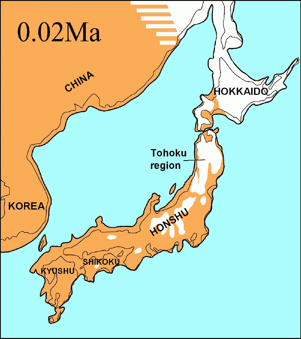
The is a strait between Honshu and Hokkaido in northern Japan connecting the Sea of Japan with the Pacific Ocean. It was named after the western part of Aomori Prefecture. The Seikan Tunnel passes under it at its narrowest point 12.1 miles (19.5 km) between Tappi Misaki on the Tsugaru Peninsula in Aomori Prefecture, Honshu, and Shirakami Misaki on the Matsumae Peninsula in Hokkaido. Western maps made prior to the 20th century also referred to this waterway as the Strait of Sangar. Japan's territorial waters extend to three nautical miles (5.6 km) into the strait instead of the usual twelve, reportedly to allow nuclear-armed United States Navy warships and submarines to transit the strait without violating Japan's prohibition against nuclear weapons in its territory. The part of the Seikan Tunnel that passes under the strait is considered to be under Japanese jurisdiction. The part of the Tsugaru Strait considered to be in international waters is still within ... [...More Info...] [...Related Items...] OR: [Wikipedia] [Google] [Baidu] |
Location TsugaruPeninsulaJp
In geography, location or place are used to denote a region (point, line, or area) on Earth's surface or elsewhere. The term ''location'' generally implies a higher degree of certainty than ''place'', the latter often indicating an entity with an ambiguous boundary, relying more on human or social attributes of place identity and sense of place than on geometry. Types Locality A locality, settlement, or populated place is likely to have a well-defined name but a boundary that is not well defined varies by context. London, for instance, has a legal boundary, but this is unlikely to completely match with general usage. An area within a town, such as Covent Garden in London, also almost always has some ambiguity as to its extent. In geography, location is considered to be more precise than "place". Relative location A relative location, or situation, is described as a displacement from another site. An example is "3 miles northwest of Seattle". Absolute location An absolute locati ... [...More Info...] [...Related Items...] OR: [Wikipedia] [Google] [Baidu] |
Kyodo News
is a nonprofit cooperative news agency based in Minato, Tokyo. It was established in November 1945 and it distributes news to almost all newspapers, and radio and television networks in Japan. The newspapers using its news have about 50 million subscribers. K. K. Kyodo News is Kyodo News' business arm, established in 1972.Shrivastava, K. M. (2007). ''News agencies from pigeon to internet.'' Sterling Publishers Pvt. Ltd. p. 208. . The subdivision Kyodo News International, founded in 1982, provides over 200 reports to international news media and is located in Rockefeller Center, New York City. Their online news site is in Japanese, Chinese ( Simplified and Traditional), Korean, and English. The agency employs over 1,000 journalists and photographers, and maintains news exchange agreements with over 70 international media outlets. Satoshi Ishikawa is the news agency's president. Kyodo News was formed by Furuno Inosuke (commonly known as Furuno) is a Japanese ... [...More Info...] [...Related Items...] OR: [Wikipedia] [Google] [Baidu] |
Straits Of Japan
A strait is an oceanic landform connecting two seas or two other large areas of water. The surface water generally flows at the same elevation on both sides and through the strait in either direction. Most commonly, it is a narrow ocean channel that lies between two land masses. Some straits are not navigable, for example because they are either too narrow or too shallow, or because of an unnavigable reef or archipelago. Straits are also known to be loci for sediment accumulation. Usually, sand-size deposits occur on both the two opposite strait exits, forming subaqueous fans or deltas. Terminology The terms '' channel'', ''pass'', or ''passage'' can be synonymous and used interchangeably with ''strait'', although each is sometimes differentiated with varying senses. In Scotland, ''firth'' or ''Kyle'' are also sometimes used as synonyms for strait. Many straits are economically important. Straits can be important shipping routes and wars have been fought for control of ... [...More Info...] [...Related Items...] OR: [Wikipedia] [Google] [Baidu] |
Geography Of Japan
Japan is an archipelagic country comprising a stratovolcanic archipelago over along the Pacific coast of East Asia. It consists of 6,852 islands. The five main islands are Hokkaido, Honshu, Kyushu, Shikoku and Okinawa. There are 6,847 remote islands. The Ryukyu Islands and Nanpō Islands are south and east of the main islands. The territory covers . It is the fourth largest island country in the world and the largest island country in East Asia. The country has the 6th longest coastline at and the 8th largest Exclusive Economic Zone of in the world. The terrain is mostly rugged and mountainous with 66% forest. The population is clustered in urban areas on the coast, plains and valleys. Japan is located in the northwestern Ring of Fire on multiple tectonic plates. East of the Japanese archipelago are three oceanic trenches. The Japan Trench is created as the oceanic Pacific Plate subducts beneath the continental Okhotsk Plate. The continuous subduction process causes ... [...More Info...] [...Related Items...] OR: [Wikipedia] [Google] [Baidu] |
Exclusive Economic Zone Of Japan
Japan has the eighth-largest exclusive economic zone (EEZ) in the world. The total area of Japan is about 37 km. Japan's EEZ area is vast and the territorial waters (including the Seto Inland Sea) and EEZ together is about 12 million km2. Geography The Japanese Archipelago consists of about 6,852 islands. The Exclusive Economic Zone of Japan includes: History In the 18th century, Dutch law scholar Cornelius van Bynkershoek wrote in his book "De Dominio Maris Dissertatio" (1702) that the coastal states control the waters within the range of cannons carried on warships of the time. This theory was supported by many countries, and the idea of having three nautical miles from the coastline as the territorial sea was established. In the 20th century, there have emerged examples of extending the scope of territorial waters, or claiming similar rights in areas beyond the territorial waters. These claims were advocated by Dr. Pardeau, UN Ambassador of the Republic ... [...More Info...] [...Related Items...] OR: [Wikipedia] [Google] [Baidu] |
Blakiston's Line
The Blakiston Line or Blakiston's Line is a faunal boundary line drawn between two of the four largest islands of Japan: Hokkaidō in the north and Honshū, south of it. It can be compared with faunal boundary lines like the Wallace Line. Certain animal species can only be found north of Blakiston's Line, while certain other species can only be found south of it. Thomas Blakiston, who lived in Japan from 1861 to 1884 and who spent much of that time in Hakodate, Hokkaido, was the first person to notice that animals in Hokkaidō, Japan's northern island, were related to northern Asian species, whereas those on Honshū to the south were related to those from southern Asia. The Tsugaru Strait between the two islands was therefore established as a zoogeographical boundary, and became known as ''Blakiston's Line''. This finding was first published to the Asiatic Society of Japan in a paper of 14 February 1883, named ''Zoological Indications of Ancient Connection of the Japan islands wi ... [...More Info...] [...Related Items...] OR: [Wikipedia] [Google] [Baidu] |
Thomas Blakiston
Thomas Wright Blakiston (27 December 1832 – 15 October 1891) was an English explorer and naturalist. Early life and career Born in Lymington, Hampshire, Blakiston was the son of Major John Blakiston. His grandfather was Sir Matthew Blakiston, 2nd Baronet Blakiston. His mother Jane was the daughter of Reverend Thomas Wright, Rector of Market Bosworth, Leicestershire. Blakiston explored western Canada with the Palliser Expedition between 1857 and 1859. Mount Blakiston, the highest point in Waterton Lakes National Park was named for him in 1858. In 1861, he traveled up the Yangtze River in China, going further than any Westerner before him. He spent the next part of his life in Japan and became one of the major naturalists in that country. Blakiston was the first person to notice that animals in Hokkaidō, Japan's northern island, were related to northern Asian species, whereas those on Honshū to the south were related to those from southern Asia. The Tsugaru Stra ... [...More Info...] [...Related Items...] OR: [Wikipedia] [Google] [Baidu] |
Tōya Maru
was a Japanese train ferry constructed by Japanese National Railways (JNR) which sank during Typhoon Marie, known locally as the Tōya Maru Typhoon, in the Tsugaru Strait between the Japanese islands of Hokkaidō and Honshū on September 26, 1954. JNR announced in September 1955 that 1,153 people aboard were killed in the accident. However, the exact number of fatalities remains unknown because some victims managed to obtain passage on the ship at the last minute, and others canceled their tickets just before the incident occurred. Construction ''Tōya Maru'' was launched on November 21, 1947. She was long and at her beam and she had a gross register tonnage of . She could accommodate 1,128 passengers and was operated by a crew of 120. She covered the distance from Aomori to Hakodate in 4 hours and 30 minutes. As early as 1950, she was fitted with radar equipment, becoming one of the first Japanese sea liners to be so equipped. She was used by the Emperor the month before s ... [...More Info...] [...Related Items...] OR: [Wikipedia] [Google] [Baidu] |
Seikan Ferry
The is a privately owned ferry service crossing the Tsugaru Strait, which separates the Japanese islands of Hokkaido and Honshu. The company, , was founded in 1973 and runs between the cities of Aomori on the northern tip of Honshu and Hakodate in southern Hokkaido. Route This route links the Port of Hakodate in Hakodate with the Port of Aomori in Aomori is the capital city of Aomori Prefecture, in the Tōhoku region of Japan. , the city had an estimated population of 278,964 in 136,457 households, and a population density of 340 people per square kilometer spread over the city's total area of .... A trip takes three hours and twenty minutes one way, and is operated by four ships: the ''Hayabusa'', ''Hayabusa 3'', ''Asakaze 5'', and ''Asakaze 21''. Each ship makes two round trips a day, with a total of eight round trips per day between Aomori and Hakodate. With the conversion of the Seikan Tunnel from conventional trains to the Hokkaido Shinkansen, this route has see ... [...More Info...] [...Related Items...] OR: [Wikipedia] [Google] [Baidu] |
Tsugaru Kaikyō Ferry
The is a privately owned ferry service crossing the Tsugaru Strait, which separates Hokkaido from Honshu. The ferries run two routes: Hakodate to Aomori and Hakodate to Ōma. Routes Hakodate—Aomori This route links the Port of Hakodate in Hakodate, Hokkaido with the Port of Aomori in Aomori. A trip takes three hours and twenty minutes one way, and is operated by four ships: the ''Blue Mermaid'', ''Blue Dolphin'', ''Blue Happiness'', and ''Blue Luminous''. Each ship makes two rounds trips a day. With the conversion of the Seikan Tunnel from convention trains into the Hokkaido Shinkansen, this route has seen a resurgence in ridership as the cheaper alternative. It connects Japan National Route 4 in Aomori with Japan National Route 5 in Hakodate. Hakodate—Ōma This route links Hakodate with the Port of Ōma in Ōma, Aomori. National Routes 279 and 338 run along this route as well. A trip takes ninety minutes one way, and is operated by the with two round trips a day. Histor ... [...More Info...] [...Related Items...] OR: [Wikipedia] [Google] [Baidu] |


