|
Tsipikan (river)
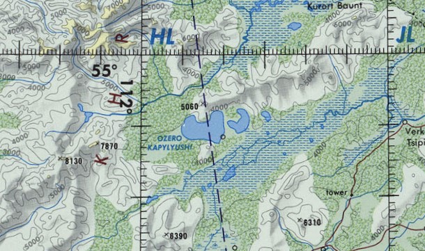
The Tsipikan (russian: Ципикан) is a river in Buryatia, Russia. It is the second largest tributary of the Tsipa, after the Amalat, of the Vitim basin. The river is long, and has a drainage basin of . There is gold mining in the banks of the river. Course The Tsipikan is a tributary of the Tsipa. It has its sources in the eastern slopes of the Ikat Range. First it flows northeastwards as it progresses across the mountains of the northwestern corner of the Vitim Plateau. Its course slows down and becomes marshy in the Kapylyushi lake area, south of the slopes of the Bolshoy Khapton. After a sharp turn to the southeast, and then northeast, it ends up flowing northwards meandering strongly and finally entering the eastern shore of lake Baunt. Tsipikan village is located on the right bank of the river. There are many swampy stretches in the Tsipikan basin, as well as 863 lakes with a total area of . The main tributaries of the Tsipikan are the long Taloy from the right, ... [...More Info...] [...Related Items...] OR: [Wikipedia] [Google] [Baidu] |
Ikat Range
Ikat Range () is a mountain range in Buryatia, Russia. It runs in a parallel direction to the Baikal Rift. The range is named after two small rivers sharing the name "Ikat" which have their sources in opposite slopes of the range one is a tributary of the Gargi (Barguzin basin) and the other a tributary of the Vitimkan (Vitim basin). The name of the range originated in an Evenki word. A section of the northwestern slopes of the range is part of the Dzherginsky Nature Reserve, a protected area. Google Earth Geography The Ikat range is located in Central Buryatia, east of the Baikal Lake. It stretches for from southwest to northeast at the western limit of the Vitim Plateau. The width of the range is from and and its average elevation between and .Икатский хребет |
Tsipa
The Tsipa (russian: Ципа) is the largest tributary of the Vitim in Buryatia, Russia. It is long, and has a drainage basin of . Maksim Perfilyev was the first Russian to reach the Tsipa in 1640. Perch, pike, lenok, grayling, taimen and whitefish are also found in the waters of the Tsipa. Course The Tsipa is a western, left tributary of the Vitim. It has its sources in a tarn of the Southern Muya Range, in the area where this range merges with the Ikat Range. It is known as "Upper Tsipa" (Верхняя Ципа) in its upper course until its mouth in lake Baunt in the Baunt Depression in the northeastern part of the Vitim Plateau, near the Bolshoy Khapton Range. The river flows out of the lake in a NNE direction and slows down meandering across a swampy basin where there are many lakes, the largest of which is Busani. Then it turns south and crosses the Babanty Range through a narrow valley where it flows fast, forming rapids. After leaving the mountains it turns aga ... [...More Info...] [...Related Items...] OR: [Wikipedia] [Google] [Baidu] |
Baunt
Baunt (russian: Баунт; bxr, Баунт нуур, ''Baunt nuur'') is the name of a body of fresh water in the Bauntovsky District, Buryatia, Russia. The village of Kurort Baunt, where there are some hot springs, is located on the southwestern shore of the lake, at the foot of Mt Bolshoy Khapton, near the confluence of the Upper Tsipa, and the village of Baunt is on the northeastern shore. At a headland named Cape Tryokhstanka there are ancient petroglyphs. The lake is a protected area since 1988. Its environment provides a habitat for a number of fish and bird species, as well as the crustacean '' Asellus aquaticus''. Geography The lake has a roughly triangular shape. It stretches in a southwest-northeast direction parallel to the main ridge of the Southern Muya Range to the north and the Baunt Basin, with the Maly Khapton and Babanty Range, two ranges of the Vitim Plateau, to the south. The Ikat Range rises to the west and the Kapylyushi lakes lie to the southwest. ... [...More Info...] [...Related Items...] OR: [Wikipedia] [Google] [Baidu] |
Google Earth
Google Earth is a computer program that renders a 3D representation of Earth based primarily on satellite imagery. The program maps the Earth by superimposing satellite images, aerial photography, and GIS data onto a 3D globe, allowing users to see cities and landscapes from various angles. Users can explore the globe by entering addresses and coordinates, or by using a keyboard or mouse. The program can also be downloaded on a smartphone or tablet, using a touch screen or stylus to navigate. Users may use the program to add their own data using Keyhole Markup Language and upload them through various sources, such as forums or blogs. Google Earth is able to show various kinds of images overlaid on the surface of the earth and is also a Web Map Service client. In 2019, Google has revealed that Google Earth now covers more than 97 percent of the world, and has captured 10 million miles of Street View imagery. In addition to Earth navigation, Google Earth provides a series ... [...More Info...] [...Related Items...] OR: [Wikipedia] [Google] [Baidu] |
Russia
Russia (, , ), or the Russian Federation, is a transcontinental country spanning Eastern Europe and Northern Asia. It is the largest country in the world, with its internationally recognised territory covering , and encompassing one-eighth of Earth's inhabitable landmass. Russia extends across eleven time zones and shares land boundaries with fourteen countries, more than any other country but China. It is the world's ninth-most populous country and Europe's most populous country, with a population of 146 million people. The country's capital and largest city is Moscow, the largest city entirely within Europe. Saint Petersburg is Russia's cultural centre and second-largest city. Other major urban areas include Novosibirsk, Yekaterinburg, Nizhny Novgorod, and Kazan. The East Slavs emerged as a recognisable group in Europe between the 3rd and 8th centuries CE. Kievan Rus' arose as a state in the 9th century, and in 988, it adopted Orthodox Christianity from the ... [...More Info...] [...Related Items...] OR: [Wikipedia] [Google] [Baidu] |
Buryatia
Buryatia, officially the Republic of Buryatia (russian: Республика Бурятия, r=Respublika Buryatiya, p=rʲɪsˈpublʲɪkə bʊˈrʲætʲɪjə; bua, Буряад Улас, Buryaad Ulas, , mn, Буриад Улс, Buriad Uls), is a republic of Russia located in Siberia. It is the historical native land of indigenous Buryats. Formerly part of the Siberian Federal District, it has been a part of the Russian Far East since 2018. Its capital is the city of Ulan-Ude, which means Red Gateway in Buryat Mongolian. Its area is with a population of 978,588 ( 2021 Census). Geography The republic is located in the south-central region of Siberia along the eastern shore of Lake Baikal. *Area: *Borders: **Internal: Irkutsk Oblast (W/NW/N), Zabaykalsky Krai (NE/E/SE/S), Tuva (W) **International: Mongolia ( Bulgan Province, Khövsgöl Province and Selenge Province) (S/SE) **Water: Lake Baikal (N) *Highest point: Mount Munku-Sardyk () Rivers Major rivers include ... [...More Info...] [...Related Items...] OR: [Wikipedia] [Google] [Baidu] |
Amalat
The Amalat (russian: Амалат) is a river in Buryatia, Russia. It is the largest tributary of the Tsipa, of the Vitim basin.Ципа / '':'' in 30 vols. / Ch. ed. A.M. Prokhorov. - 3rd ed. - M. Soviet Encyclopedia, 1969-1978. The river is long, and has a drainage basin of . The villages of Baysa, and |
Vitim (river)
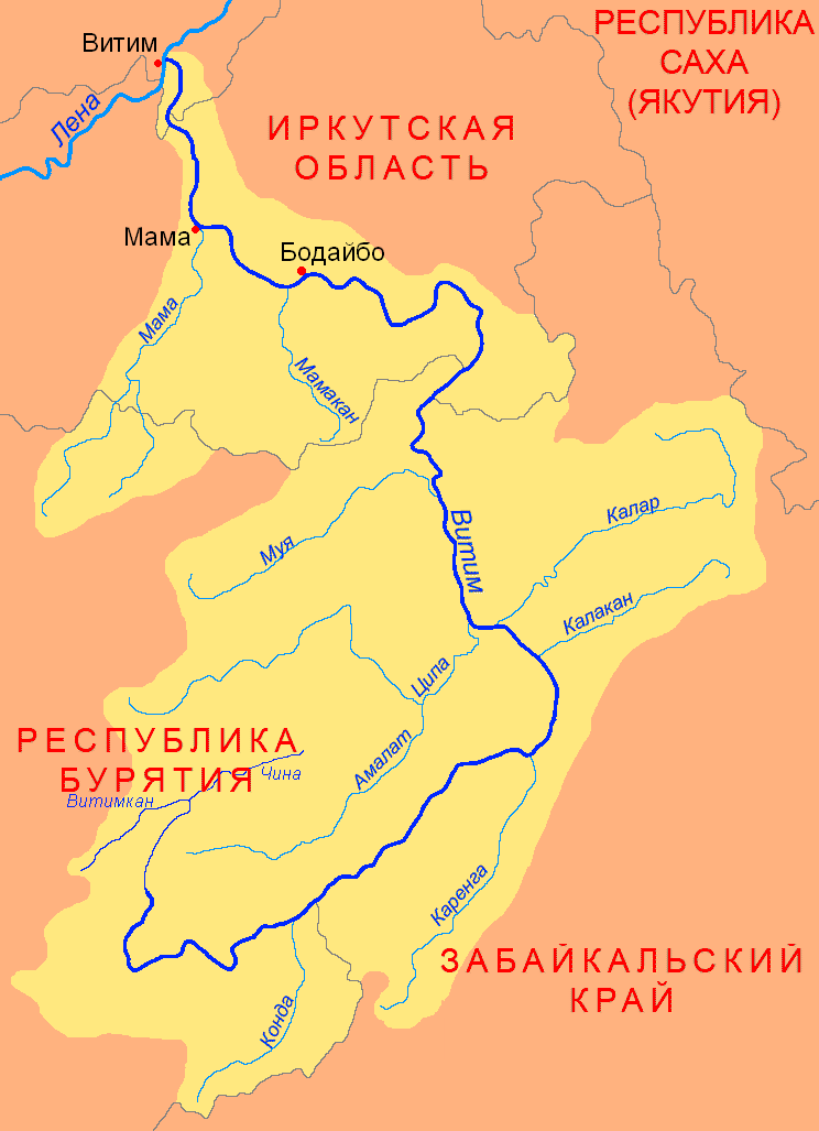
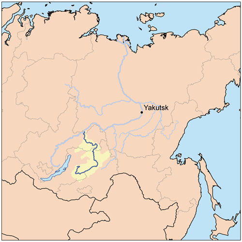
The Vitim (russian: Витим; evn, Витым, ; sah, Виитим, ; Buryat and mn, Витим, ''Vitim'') is a major tributary of the Lena. Its source is east of Lake Baikal, at the confluence of rivers Vitimkan from the west and China from the east. The Vitim flows first south, bends eastwards and then northward in the Vitim Plateau. Then it flows north through the Stanovoy Highlands and the town of Bodaybo. Including river Vitimkan, its western source, it is long, and has a drainage basin of .Витим (река в Бурят. АССР) It is navigable from the Lena to Bodaybo. Upst ... [...More Info...] [...Related Items...] OR: [Wikipedia] [Google] [Baidu] |
Vitim Plateau
Vitim Plateau is a plateau in Buryatia and Zabaykalsky Krai, Russia. The plateau is sparsely populated, the main settlements are Romanovka and Bagdarin. An area of the plateau is an ancient volcanic field with a number of cinder cones and volcanoes, the last of which was active about 810,000 years before present. The P436 regional road connecting Ulan-Ude and Chita passes through Romanovka across the plateau. Geography The Vitim Plateau lies along the headwaters of the Vitim River, a tributary of the Lena between the Southern Muya Range to the north, the Ikat Range to the west, the Yablonoi Mountains to the south, and in the east with the lower reaches of the Kalakan River to the right bank of the lower reaches of the Karenga River (both Vitim tributaries) and the latter's right tributary, the Bugarikta. The Vitim River begins at the confluence of the China and Vitimkan rivers on the plateau and makes a wide bend around the volcanic zone before flowing northwards. R ... [...More Info...] [...Related Items...] OR: [Wikipedia] [Google] [Baidu] |
Kapylyushi
Kapylyushi (russian: Капылюши) or Kapylyushy is a body of fresh water in the Bauntovsky District, Buryatia, Russia. The name originated in an Evenki word. The lake is located in the northwestern corner of the Vitim Plateau, near the left bank of river Tsipikan, of the Vitim river basin. Together with lake Baunt it belongs to the "Tsipo-Tsipikansky" (Ципо-Ципиканских) lake group —after rivers Tsipa and Tsipikan, which is also known as Bauntovsky (Баунтовских) —after lake Baunt. The study of the whole lake area began only in the 1930s in the course of an expedition of the Krasnoyarsk branch of the Research Institute of Freshwater Fisheries of the USSR. The results of the research were published in 1936 in the Handbook of Water Resources of the USSR. Geography The Kapylyushi lake system has two parts: Big Kapylyushi (Bolshoy Kapylyushi or Oron) is the larger lake in the west, and Kapyluchikan (russian: Капылучикан), also kno ... [...More Info...] [...Related Items...] OR: [Wikipedia] [Google] [Baidu] |
Bolshoy Khapton
The Bolshoy Khapton (russian: Большой Хаптон) is a mountain range in Bauntovsky District, Buryatia, Russia. The nearest airport is Bagdarin Airport. Google Earth Geography This mountain range is located in the northeastern part of the Vitim Plateau. It stretches from southwest to northeast for almost 50 km between the Kapylyushi lake group and the southern shores of Baunt lake. The Bolshoy Khapton range is part of the watershed of the Tsipikan and Upper Tsipa rivers. In its eastern section it reaches a maximum width of 10 km. The highest point of the range is high Mt Bolshoy Khapton. to the south, across the Tsipikan River, rises the smaller Maly Khapton range, highest point . It runs parallel to the Bolshoy Khapton at the southern limit of the Baunt Depression. See also *List of mountains and hills of Russia This is a list of mountains and hills of Russia. List by elevation Over 5000 meters 4000 to 4999 meters 3000 to 3999 meters 2000 to 2999 m ... [...More Info...] [...Related Items...] OR: [Wikipedia] [Google] [Baidu] |
Meandering
A meander is one of a series of regular sinuous curves in the Channel (geography), channel of a river or other watercourse. It is produced as a watercourse erosion, erodes the sediments of an outer, concave bank (cut bank) and deposits sediments on an inner, convex bank which is typically a point bar. The result of this coupled erosion and sedimentation is the formation of a sinuous course as the channel migrates back and forth across the axis of a floodplain. The zone within which a meandering stream periodically shifts its channel is known as a meander belt. It typically ranges from 15 to 18 times the width of the channel. Over time, meanders migrate downstream, sometimes in such a short time as to create civil engineering challenges for local municipalities attempting to maintain stable roads and bridges.Neuendorf, K.K.E., J.P. Mehl Jr., and J.A. Jackson, J.A., eds. (2005) ''Glossary of Geology'' (5th ed.). Alexandria, Virginia, American Geological Institute. 779 pp. Charlto ... [...More Info...] [...Related Items...] OR: [Wikipedia] [Google] [Baidu] |


