|
Transdanubian Mountains
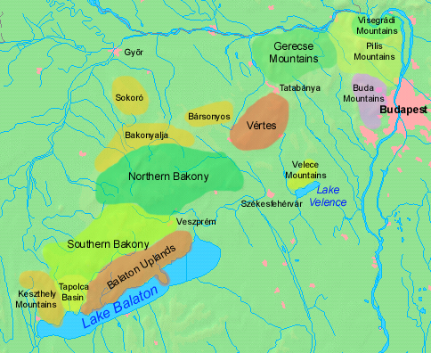
__NOTOC__ The Transdanubian Mountains (sometimes also referred to as ''Bakony Forest, Dunántúl Highlands, Highlands of Dunántúl, Highlands of Transdanubia, Mountains of Dunántúl, Mountains of Transdanubia, Transdanubian Central Range, Transdanubian Hills, Transdanubian Midmountains'' or ''Transdanubian Mid-Mountains'', ) are a mountain range in Hungary covering about 7000 km2. Its highest peak is the ''Pilis'', with a height of . Parts of the mountains *Bakony ** ''Southern Bakony'' ** ''Northern Bakony'' *** Keszthely Plateau *** Tapolca Basin *** Balaton Uplands **** Bakonyalja **** Sokoró Hills *Vértes Mountains ** Vértesalja (Bársonyos) *Velence Hills * Dunazug Mountains **Gerecse Mountains **Buda Hills ** Pilis Mountains Visegrád Mountains are often considered a part of it for geopolitical reasons, but geographically they are part of the North Hungarian Mountains. Gallery File:Gulács01.jpg File:Pliocene Volcanoes near Lake Balaton in Hungary.jpg File: ... [...More Info...] [...Related Items...] OR: [Wikipedia] [Google] [Baidu] |
Badacsony
Badacsony () is the name of a region on the north shore of Lake Balaton in western Hungary, a mountain top and a town in that region. The nearby basalt mountains are unique geological relics, and the habitat of many rare plants and animals. These monadnocks are peculiarly shaped results of volcanic activity, formed before the period wherein Pannonia was an active geologic unit. Badacsony is the central part of the Badacsony wine region. On the Badacsony mountain, poet Sándor Kisfaludy lived and first met his wife, Róza Szegedy. This event is commemorated by a small exhibition in a house on the mountain, the Róza Szegedy house, whilst the former house of Kisfaludy himself is now a restaurant. Badacsony has a ferry landing with regular departures to Fonyód via a catamaran A Formula 16 beachable catamaran Powered catamaran passenger ferry at Salem, Massachusetts, United States A catamaran () (informally, a "cat") is a multi-hulled watercraft featuring two parallel ... [...More Info...] [...Related Items...] OR: [Wikipedia] [Google] [Baidu] |
Pannonian Island Mountains
The Pannonian island mountains ( sr, / , hr, Panonske otočne planine) is a term for isolated mountains scattered across the Pannonian Plain, chiefly its western and southern parts, in Hungary, Serbia and Croatia. In prehistoric times, these mountains were islands of the ancient Pannonian Sea that disappeared about 600,000 years ago. The island mountains include: ;Croatia *Central Slavonian Mountains: **Dilj ** Krndija ** Papuk **Psunj ** Požeška Gora *Medvednica in western Croatia ;Hungary *Transdanubian Mountains of western Hungary: **Bakony **Buda Hills **Gerecse Gerecse is a mountain range in north-western Hungary, that belongs to the Transdanubian Mountains Geography The range lies in the Central Transdanubian region and connects Vértes Hills with Pilis Mountains in Komárom-Esztergom County, betw ... ** Pilis Mountains **Vértes Hills **Velence Mountains *Mecsek, in south Hungary *Kőszeg Mountains (Geschriebenstein), on Austria–Hungary border, Hungary– ... [...More Info...] [...Related Items...] OR: [Wikipedia] [Google] [Baidu] |
Geography Of Hungary
Hungary is a landlocked country in East-Central Europe with a land area of 93,030 square km. It measures about 250 km from north to south and 524 km from east to west. It has 2,106 km of boundaries, shared with Austria to the west, Serbia, Croatia and Slovenia to the south and southwest, Romania to the southeast, Ukraine to the northeast, and Slovakia to the north. Hungary's modern borders were first established after World War I when, by the terms of the Treaty of Trianon in 1920, it lost more than 71% of what had formerly been the Kingdom of Hungary, 58.5% of its population, and 32% of the Hungarians. The country secured some boundary revisions from 1938 to 1941: In 1938 the First Vienna Award gave back territory from Czechoslovakia, in 1939 Hungary occupied Carpatho-Ukraine. In 1940 the Second Vienna Award gave back Northern Transylvania and finally Hungary occupied the Bácska and Muraköz regions during the Invasion of Yugoslavia. However, Hungary lost these ... [...More Info...] [...Related Items...] OR: [Wikipedia] [Google] [Baidu] |
Transdanubia
Transdanubia ( hu, Dunántúl; german: Transdanubien, hr, Prekodunavlje or ', sk, Zadunajsko :sk:Zadunajsko) is a traditional region of Hungary. It is also referred to as Hungarian Pannonia, or Pannonian Hungary. Administrative divisions Traditional interpretation The borders of Transdanubia are the Danube River (north and east), the Drava and Mura rivers (south), and the foothills of the Alps roughly along the border between Hungary and Austria (west). Transdanubia comprises the counties of Győr-Moson-Sopron, Komárom-Esztergom, Fejér, Veszprém, Vas, Zala, Somogy, Tolna, Baranya and the part of Pest that lies west of the Danube. (In the early Middle Ages the latter was known as Pilis county.) This article deals with Transdanubia in this geographical meaning. Territorial changes While the northern, eastern and southern borders of the region are clearly marked by the Danube and Drava rivers, the western border was always identical with the political boundary of ... [...More Info...] [...Related Items...] OR: [Wikipedia] [Google] [Baidu] |
North Hungarian Mountains
The North Hungarian Mountains ( hu, Északi-középhegység), sometimes also referred to as the Northeast Hungarian Mountains, Northeast Mountains, North Hungarian Highlands, North Hungarian Mid-Mountains or North Hungarian Range, is the northern, mountainous part of Hungary. It forms a geographical unity with the Mátra-Slanec Area, the adjacent parts of Slovakia. It is a separate geomorphological area within the Western Carpathians. The mountains run along the northeastern border of Hungary as well as eastern parts of the Hungarian–Slovak border in broadband from the Danube Bend to the town of Prešov. Subdivisions The area consists of the following geomorphological units: * Börzsöny Regional Map Series of Hungary ( hu, Börzsöny + [...More Info...] [...Related Items...] OR: [Wikipedia] [Google] [Baidu] |
Visegrád Mountains
The Visegrád Mountains (Hu: ''Visegrádi hegység'') is a mountain range in Hungary, not far from Budapest. Geography The Visegrád Mountains are the direct northern neighbour of the Pilis Mountains. Although the two ranges form a geographical unit as both of them officially belong to the Transdanubian Mountains, the Visegrád Mountains connect to Börzsöny and the North Hungarian Mountains. The mountain range is the southernmost part of the Inner Western Carpathians. The basic rock of these mountains is volcanic, mainly andesite, while the Transdanubian Mountains are based on sedimentary rocks. Geology Visegrád Mountains were shaped by volcanic events. History of the region The whole range served as the hunting area for the medieval kings. Notable locations The highest peak of the range is at Dobogókő (699 m above sea level), a hiking and ski resort area with a panoramic view on the Danube Bend The Danube Bend ( hu, Dunakanyar) is a curve of the Danube in ... [...More Info...] [...Related Items...] OR: [Wikipedia] [Google] [Baidu] |
Pilis Mountains
Pilis Mountains is a mountainous region in the Transdanubian Mountains. Its highest peak is ''Pilis-tető'' at . It is a popular hiking destination in Hungary. It is the direct southern neighbour of the Visegrád Mountains which are based on volcanic rocks while Pilis is sedimentary. History of the region The region used to be a hunting area for the mediaeval kings. Numerous hunting lodges have survived. One of the most frequented areas was around the village Pilisszentkereszt. Mountains of the range * , the second highest point of Transdanubia Transdanubia ( hu, Dunántúl; german: Transdanubien, hr, Prekodunavlje or ', sk, Zadunajsko :sk:Zadunajsko) is a traditional region of Hungary. It is also referred to as Hungarian Pannonia, or Pannonian Hungary. Administrative divisions Trad .... * * Csikóváralja References Transdanubian Mountains Biosphere reserves of Hungary {{Hungary-geo-stub ... [...More Info...] [...Related Items...] OR: [Wikipedia] [Google] [Baidu] |
Buda Hills
The Buda Hills ( Hungarian: ''Budai-hegység'') are a low mountain range of numerous hills which dot the Buda side of Budapest, capital of Hungary. The most famous ones located within city limits are Gellért Hill, Castle Hill, Rózsadomb, , János Hill, and Eagle Hill. These hills consist of both nature and residential areas. Geology The Budaörs dolomite of Anisian-Carnian age (Triassic period) is the oldest formation which crops out in the Buda Hills. Younger Triassic succession is composed of cherty dolomite and limestone (basin facies), and dolomite combined with limestone (platform facies). The Trassic surface is composed of karstified carbonates, which are overlain by an Upper Eocene succession made of conglomerate beds. During the period from the terminal Cretaceous to Priabonian, the area was a karstic terrestrial environment displaying distinct relief differences. It was also the time when Triassic formations were eroded. The continental period (ended by the ... [...More Info...] [...Related Items...] OR: [Wikipedia] [Google] [Baidu] |
Gerecse Mountains
Gerecse is a mountain range in north-western Hungary, that belongs to the Transdanubian Mountains Geography The range lies in the Central Transdanubian region and connects Vértes Hills with Pilis Mountains in Komárom-Esztergom County, between the town of Tatabánya and the Danube River. Gerecse occupies an area of 850 km2 (20,300 ha). The highest point is ''Nagy-Gerecse'' at 634 m. The main rock is limestone and chalk. Biology Deciduous oak forests cover the lower slopes, with submontane species of Quercus, Carpinus, Fagus, and at higher altitudes karst scrub. The area is 70% forest, 5% scrubland, 10% grassland, and 15% artificial landscapes. Yearly sunshine duration is around 1,980 hours. The average annual temperature above the height of 350 meters is 9.5 C (in January -2,8 C). The average annual precipitation is 640 millimeters. Gallery Image:Farkasvölgy.jpg, Farkasvölgy (Wolf-valley) Image:Forest in Gerecse Mountains.jpg, Forest in the Gerecse Image:Pusztam ... [...More Info...] [...Related Items...] OR: [Wikipedia] [Google] [Baidu] |
Dunazug Mountains
Dunazug Mountains (Hu: ''Dunazug hegyvidék'') is a part of Transdanubian Mountains in Hungary. It is the easternmost part of the mountains that connects it to the Danube Bend and the capital. The name itself also comes from the river (in Hungarian ''Duna''), while ''zug'' means ''recess'', ''corner''. The highest peak is ''Pilis-tető'', about 750 metres, The mountains are made up of sedimentary rock, mainly limestone. Parts of the mountains * Gerecse Mountains *Pilis Mountains * Buda Hills The Buda Hills ( Hungarian: ''Budai-hegység'') are a low mountain range of numerous hills which dot the Buda side of Budapest, capital of Hungary. The most famous ones located within city limits are Gellért Hill, Castle Hill, Rózsadomb, , J� ... Gallery File:Turistajelzés a Vértesben.jpg File:Gerecse pelifoldszentkeresztnel.JPG File:Gerecse látképe.jpg File:View of János Hill from Kis-Hárs Hill.JPG Sources (In Hungarian) *https://vandorbot.hu/dunazug-hegyvidek ... [...More Info...] [...Related Items...] OR: [Wikipedia] [Google] [Baidu] |
Velence Hills
Velence Hills ( hu, Velencei-hegység) is a low mountain range in north-western Hungary, in the Central Transdanubian region. It lies to the north of Lake Velence, some 15 km to the east of city of Székesfehérvár. The Velence Hills are part of the Transdanubian Mountains. Village of Nadap Nadap is a village in Fejér county in central Hungary, with population of 460. Lying among low Velence Hills, it is the point of departure for sightseeing tours on the countryside. The obelisk in the vicinity, called "ancient mark of Nadap" serve ... lies in the central part of the hills and is the point of departure of excursions to the countryside. The highest point, Meleg-hegy ("Hot hill") (352 m) lies above the village. Gallery File:Kilátás a Mészeg-hegy felé a Sarvajc kereszt meletti kilátóból, 2017 Dinnyés.jpg File:Nadap 01.jpg File:Velencei-hegység.jpeg References External links * Transdanubian Mountains {{Fejer-geo-stub ... [...More Info...] [...Related Items...] OR: [Wikipedia] [Google] [Baidu] |


