|
Tractus Catena
Tractus Catena is a set of pits in the Arcadia quadrangle of Mars. Its location is centered at . It is long and was named after a classical albedo feature name. The term "Catena" refers to a chain of craters. The line of pits that make up Tractus Catena make it related to fossa which are common on Mars. Dark slope streaks are visible in one of the pictures below. Such streaks are common on Mars. They occur on steep slopes of craters, troughs, and valleys. The streaks are dark at first. They get lighter with age. Sometimes they start in a tiny spot, then spread out and go for hundreds of meters. They have been seen to travel around obstacles, like boulders.http://www.space.com/image_of_day_080730.html It is believed that they are avalanches of bright dust that expose a darker underlying layer. Image:Tractus Catena.JPG, Tractus Catena, as seen by HiRISE. Scale bar is long. Click on image for good view of dark slope streaks Image:Tractus Catena Floor.JPG, Tractus Caten ... [...More Info...] [...Related Items...] OR: [Wikipedia] [Google] [Baidu] |
Thermal Emission Imaging System
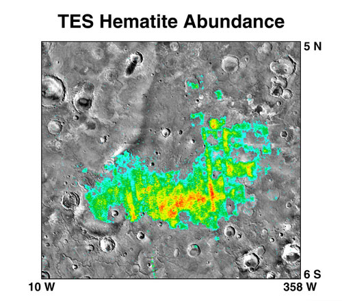
The Thermal Emission Imaging System (THEMIS) is a camera on board the 2001 Mars Odyssey orbiter. It images Mars in the visible and infrared parts of the electromagnetic spectrum in order to determine the thermal properties of the surface and to refine the distribution of minerals on the surface of Mars as determined by the Thermal Emission Spectrometer (TES). Additionally, it helps scientists to understand how the mineralogy of Mars relates to its landforms, and it can be used to search for thermal hotspots in the Martian subsurface. THEMIS is managed from the Mars Space Flight Facility at Arizona State University and was built by the Santa Barbara Remote Sensing division of Raytheon Technologies Corporation, an American multinational conglomerate headquartered in Waltham, Massachusetts. The instrument is named after Themis, the goddess of justice in ancient Greek mythology. Infrared camera THEMIS detects thermal infrared energy emitted by the Martian surface at nine di ... [...More Info...] [...Related Items...] OR: [Wikipedia] [Google] [Baidu] |
Arcadia Quadrangle
The Arcadia quadrangle is one of a series of 30 quadrangle maps of Mars used by the United States Geological Survey (USGS) Astrogeology Research Program. The quadrangle is located in the north-central portion of Mars’ western hemisphere and covers 240° to 300° east longitude (60° to 120° west longitude) and 30° to 65° north latitude. The quadrangle uses a Lambert conformal conic projection at a nominal scale of 1:5,000,000 (1:5M). The Arcadia quadrangle is also referred to as MC-3 (Mars Chart-3). The southern and northern borders of the Arcadia quadrangle are approximately 3,065 km and 1,500 km wide, respectively. The north to south distance is about 2,050 km (slightly less than the length of Greenland). The quadrangle covers an approximate area of 4.9 million square km, or a little over 3% of Mars’ surface area. The region called Tempe Terra is in the Arcadia quadrangle. Several features found in this quadrangle are interesting, especially gullies w ... [...More Info...] [...Related Items...] OR: [Wikipedia] [Google] [Baidu] |
Mars
Mars is the fourth planet from the Sun and the second-smallest planet in the Solar System, only being larger than Mercury (planet), Mercury. In the English language, Mars is named for the Mars (mythology), Roman god of war. Mars is a terrestrial planet with a thin atmosphere (less than 1% that of Earth's), and has a crust primarily composed of elements similar to Earth's crust, as well as a core made of iron and nickel. Mars has surface features such as impact craters, valleys, dunes and polar ice caps. It has two small and irregularly shaped moons, Phobos (moon), Phobos and Deimos (moon), Deimos. Some of the most notable surface features on Mars include Olympus Mons, the largest volcano and List of tallest mountains in the Solar System, highest known mountain in the Solar System and Valles Marineris, one of the largest canyons in the Solar System. The North Polar Basin (Mars), Borealis basin in the Northern Hemisphere covers approximately 40% of the planet and may be a la ... [...More Info...] [...Related Items...] OR: [Wikipedia] [Google] [Baidu] |
International Astronomical Union
The International Astronomical Union (IAU; french: link=yes, Union astronomique internationale, UAI) is a nongovernmental organisation with the objective of advancing astronomy in all aspects, including promoting astronomical research, outreach, education, and development through global cooperation. It was founded in 1919 and is based in Paris, France. The IAU is composed of individual members, who include both professional astronomers and junior scientists, and national members, such as professional associations, national societies, or academic institutions. Individual members are organised into divisions, committees, and working groups centered on particular subdisciplines, subjects, or initiatives. As of 2018, the Union had over 13,700 individual members, spanning 90 countries, and 82 national members. Among the key activities of the IAU is serving as a forum for scientific conferences. It sponsors nine annual symposia and holds a triannual General Assembly that sets policy ... [...More Info...] [...Related Items...] OR: [Wikipedia] [Google] [Baidu] |
Fossa (geology)
In planetary nomenclature, a fossa (pl. fossae ) is a long, narrow depression (trough) on the surface of an extraterrestrial body, such as a planet or moon. The term, which means "ditch" or "trench" in Latin, is not a geological term as such but a descriptor term used by the United States Geological Survey (USGS) and the International Astronomical Union (IAU) for topographic features whose geology or geomorphology is uncertain due to lack of data or knowledge of the exact processes that formed them. Fossae are believed to be the result of a number of geological processes, such as faulting or subsidence. Many fossae on Mars are probably graben. On Mars The Tharsis quadrangle is home to large troughs (long narrow depressions) called fossae in the geographical language used for Mars. This term is derived from Latin; therefore fossa is singular and fossae is plural. Troughs form when the crust is stretched until it breaks. The stretching can be due to the large weight of a nearby ... [...More Info...] [...Related Items...] OR: [Wikipedia] [Google] [Baidu] |
HiRISE
High Resolution Imaging Science Experiment is a camera on board the ''Mars Reconnaissance Orbiter'' which has been orbiting and studying Mars since 2006. The 65 kg (143 lb), US$40 million instrument was built under the direction of the University of Arizona's Lunar and Planetary Laboratory by Ball Aerospace & Technologies Corp. It consists of a 0.5m (19.7 in) aperture reflecting telescope, the largest so far of any deep space mission, which allows it to take pictures of Mars with resolutions of 0.3m/pixel (1ft/pixel), resolving objects below a meter across. HiRISE has imaged Mars exploration rovers on the surface, including the ''Opportunity'' rover and the ongoing ''Curiosity'' mission. History In the late 1980s, of Ball Aerospace & Technologies began planning the kind of high-resolution imaging needed to support sample return and surface exploration of Mars. In early 2001 he teamed up with Alfred McEwen of the University of Arizona to propose such a c ... [...More Info...] [...Related Items...] OR: [Wikipedia] [Google] [Baidu] |
Dark Slope Streaks
Dark slope streaks are narrow, avalanche-like features common on dust-covered slopes in the equatorial regions of Mars.Chuang, F.C.; Beyer, R.A.; Bridges, N.T. (2010). Modification of Martian Slope Streaks by Eolian Processes. ''Icarus,'' 205 154–164. They form in relatively steep terrain, such as along escarpments and crater walls.Schorghofer, N.; Aharonson, O.; Khatiwala, S. (2002). Slope Streaks on Mars: Correlations with Surface Properties and the Potential Role of Water. ''Geophys. Res. Lett.,'' 29(23), 2126, . Although first recognized in Viking Orbiter images from the late 1970s,Morris, E.C. (1982). Aureole Deposits of the Martian Volcano Olympus Mons. ''J. Geophys. Res.,'' 87(B2), 1164–1178.Ferguson, H.M.; Lucchitta, B.K. (1984). Dark Streaks on Talus Slopes, Mars in ''Reports of the Planetary Geology Program 1983, NASA Tech. Memo., TM-86246,'' pp. 188–190. https://ntrs.nasa.gov/archive/nasa/casi.ntrs.nasa.gov/19840015363_1984015363.pdf. dark slope streaks were not s ... [...More Info...] [...Related Items...] OR: [Wikipedia] [Google] [Baidu] |
Geology Of Mars
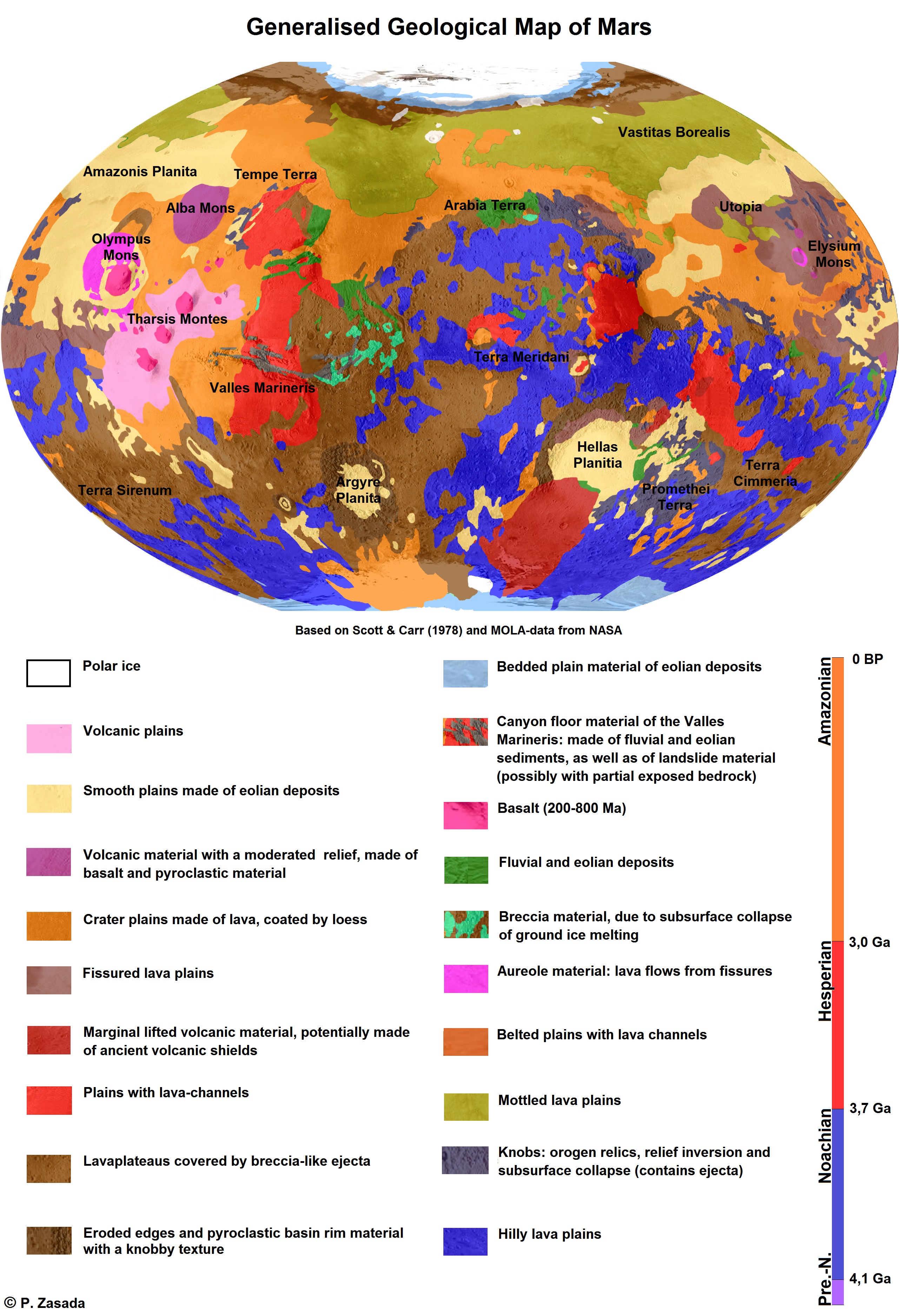
The geology of Mars is the scientific study of the surface, crust, and interior of the planet Mars. It emphasizes the composition, structure, history, and physical processes that shape the planet. It is analogous to the field of terrestrial geology. In planetary science, the term ''geology'' is used in its broadest sense to mean the study of the solid parts of planets and moons. The term incorporates aspects of geophysics, geochemistry, mineralogy, geodesy, and cartography. A neologism, areology, from the Greek word ''Arēs'' (Mars), sometimes appears as a synonym for Mars's geology in the popular media and works of science fiction (e.g. Kim Stanley Robinson, Kim Stanley Robinson's Mars trilogy). The term areology is also used by the Areological Society. Geological map of Mars (2014) File:Geologic Map of Mars figure2.pdf, Figure 2 for the geologic map of Mars Global Martian topography and large-scale features Composition of Mars Mars is a terrestrial planet, whic ... [...More Info...] [...Related Items...] OR: [Wikipedia] [Google] [Baidu] |


