|
Toshka Lakes
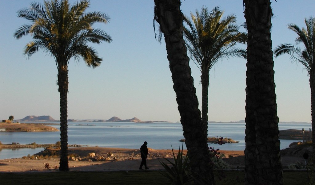
Toshka Lakes ( ar, بحيرات توشكى, ) is the name given to recently formed endorheic lakes in the Sahara Desert of Egypt. Etymology The lakes are named after a Nubian village Toshka (Old Nubian: ⲧⲱϣⲕⲉⲁ) which was drowned after the construction of the Aswan High Dam. History The Aswan High Dam, constructed in Egypt in 1964–1968, created Lake Nasser, with a maximum water level of above sea level. In the '90s excess water started being released from Lake Nasser by overflow into a hollow at the south end of the Eocene limestone plateau. Formation Astronauts began noticing the first, easternmost lake growing in November 1998. By late 1999, three additional lakes formed successively westward, and the westernmost lake started forming sometime between September 2000 and March 2001. These lakes are not yet named individually. In total, the Toshka Lakes cover approximately 1300 square kilometers (502 mi2). The levels of the lakes are lower than in 2001, an ... [...More Info...] [...Related Items...] OR: [Wikipedia] [Google] [Baidu] |
New Valley Governorate
New Valley Governorate or El Wadi El Gedid Governorate ( ar, محافظة الوادي الجديد , ) is one of the governorates of Egypt. It is in the southwestern part of the country, in the south of Egypt Western Desert (Egypt), Western Desert (part of the Sahara Desert), between the Nile, northern Sudan, and southeastern Libya. Consisting of roughly half of Egypt's area, this spacious governorate is the country's largest and most sparsely populated, and one of the List of country subdivisions by area, biggest subnational divisions on the African continent, as well as the world. At 440,098 square kilometers in area, New Valley Governorate is just slightly larger than the country of Iraq. The capital is at the Kharga Oasis. New Valley Governate is named after the New Valley Project, which aims to irrigate parts of the Western Desert. Municipal divisions The governorate is divided into Subdivisions_of_Egypt#Municipal_divisions, municipal divisions with a total est ... [...More Info...] [...Related Items...] OR: [Wikipedia] [Google] [Baidu] |
Eocene
The Eocene ( ) Epoch is a geological epoch (geology), epoch that lasted from about 56 to 33.9 million years ago (mya). It is the second epoch of the Paleogene Period (geology), Period in the modern Cenozoic Era (geology), Era. The name ''Eocene'' comes from the Ancient Greek (''ēṓs'', "dawn") and (''kainós'', "new") and refers to the "dawn" of modern ('new') fauna that appeared during the epoch. The Eocene spans the time from the end of the Paleocene Epoch to the beginning of the Oligocene Epoch. The start of the Eocene is marked by a brief period in which the concentration of the carbon isotope Carbon-13, 13C in the atmosphere was exceptionally low in comparison with the more common isotope Carbon-12, 12C. The end is set at a major extinction event called the ''Grande Coupure'' (the "Great Break" in continuity) or the Eocene–Oligocene extinction event, which may be related to the impact of one or more large bolides in Popigai impact structure, Siberia and in what is now ... [...More Info...] [...Related Items...] OR: [Wikipedia] [Google] [Baidu] |
MODIS
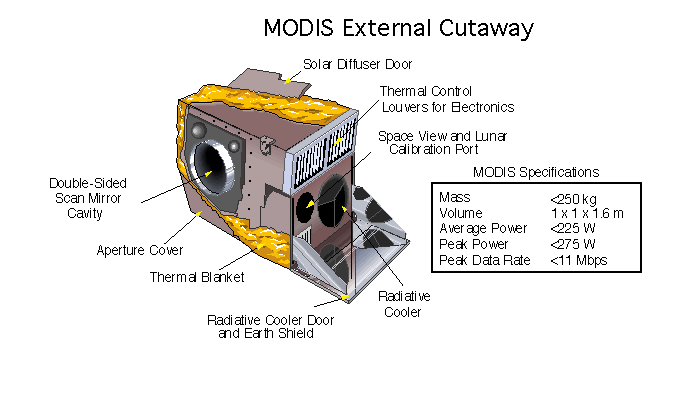
The Moderate Resolution Imaging Spectroradiometer (MODIS) is a satellite-based sensor used for earth and climate measurements. There are two MODIS sensors in Earth orbit: one on board the Terra (EOS AM) satellite, launched by NASA in 1999; and one on board the Aqua (EOS PM) satellite, launched in 2002. MODIS has now been replaced by the VIIRS, which first launched in 2011 aboard the Suomi NPP satellite. The MODIS instruments were built by Santa Barbara Remote Sensing. They capture data in 36 spectral bands ranging in wavelength from 0.4 μm to 14.4 μm and at varying spatial resolutions (2 bands at 250 m, 5 bands at 500 m and 29 bands at 1 km). Together the instruments image the entire Earth every 1 to 2 days. They are designed to provide measurements in large-scale global dynamics including changes in Earth's cloud cover, radiation budget and processes occurring in the oceans, on land, and in the lower atmosphere. Support and calibration is provided by the MO ... [...More Info...] [...Related Items...] OR: [Wikipedia] [Google] [Baidu] |
Lakes Of Egypt
Egypt contains many lakes currently and other lakes that have vanished. Current lakes Lake Nasser A vast reservoir in southern Egypt and northern Sudan created by the damming of the Nile after the construction of the High Dam of Aswan. Manzala Lake Salt or brackish water lake. In northeastern Egypt on the Nile Delta near Port Said, Damietta, Dakahlyia and Sharqyia governorates. Maryut Lake A salt lake in northern Egypt, between Alexandria and Al-Buhira (Beheira actually is named after it) Governorates. Lake Bardawil Salt water Lake in North Sinai Governorate. It is said that it is named after King Baldwin I of Jerusalem of the First Crusade and that he was buried there. Lake Moeris or Qaroun Lake Brackish water Lake. South River Nile Delta in Fayoum Governorate. Wadi Elrayan Lakes Brackish water Lake. In Fayoum Governorate Edko Lake Salt water lake in Al Bouhaira Governorate Toshka Lakes River water Lake. In South Western Part of Egypt. Great Bitter La ... [...More Info...] [...Related Items...] OR: [Wikipedia] [Google] [Baidu] |
Nile Basin Initiative
The Nile Basin Initiative (NBI) is a partnership among the Nile riparian states that “seeks to develop the river in a cooperative manner, share substantial socioeconomic benefits, and promote regional peace and security”. The NBI began with a dialogue among the riparian states that resulted in a shared vision objective “to achieve sustainable socioeconomic development through the equitable utilization of, and benefit from, the common Nile Basin water resources." It was formally launched in February 1999 by the water ministers of nine countries that share the river: Egypt, Sudan, Ethiopia, Uganda, Kenya, Tanzania, Burundi, Rwanda, the Democratic Republic of Congo (DRC), as well as Eritrea as an observer. From its beginning the Nile Basin Initiative has been supported by the World Bank and by other external partners. The World Bank has a mandate to support the work of the NBI, as lead development partner and as administrator of the multi-donor Nile Basin Trust Fund. One of the par ... [...More Info...] [...Related Items...] OR: [Wikipedia] [Google] [Baidu] |
Kharga
The Kharga Oasis (Arabic: , ) ; Coptic: ( "Oasis of Hib", "Oasis of Psoi") is the southernmost of Egypt's five western oases. It is located in the Western Desert, about 200 km (125 miles) to the west of the Nile valley. "Kharga" or "El Kharga" is also the name of a major town located in the oasis, the capital of New Valley Governorate. The oasis, which was known as the 'Southern Oasis' to the Ancient Egyptians and Oasis Magna to the Romans, is the largest of the oases in the Libyan desert of Egypt. It is in a depression about 160 km (100 miles) long and from 20 km (12 miles) to 80 km (50 miles) wide. Its population is 67,700 (2012). Overview Kharga is the most modernised of Egypt's western oases. The main town is highly functional with all modern facilities, and virtually nothing left of old architecture. Although framed by the oasis, there is no oasis feeling to it, unlike all other oases in this part of Egypt. There is extensive thorn palm, aca ... [...More Info...] [...Related Items...] OR: [Wikipedia] [Google] [Baidu] |
New Valley Project
{{coord, 22.494795, N, 28.579559, E, display=title The New Valley Project or Toshka Project consists of building a system of canals to carry water from Lake Nasser to irrigate part of the sandy wastes of the Western Desert of Egypt, which is part of the Sahara Desert. In 1997, the Egyptian government decided to develop a new valley (as opposed to the existing Nile Valley) where agricultural and industrial communities would develop. It has been an ambitious project which was meant to help Egypt cope with its rapidly growing population. The canal inlet starts from a site 8 km to the north of Toshka Bay (Khor) on Lake Nasser. The canal is meant to continue westwards until it reaches the Darb el-Arbe'ien route, then northwards along the Darb el- Arbe'ien to the Baris Oasis, covering a distance of 310 km. But as of April 2012, the canal is still 60 km short of the Baris Oasis. The Mubarak Pumping Station in Toshka is the centerpiece of the project and was ina ... [...More Info...] [...Related Items...] OR: [Wikipedia] [Google] [Baidu] |
Nubian Swell
The Nubian Swell is a geology, geologic structural swell (geology), uplift in northern Africa that trends east to west and separates the lower Nile River, Nile of Egypt from the Sudan basin. The Nubian Swell has been geologically active since early Mesozoic times, and portions of it are still active. The Nile traverses the uplift through geologic fractures and faults, and four of six cataracts of the Nile occur at places that the river crosses the uplift. References * External linksWhen did the Nile Begin?: Remote Sensing Analysis of Paleo-drainages Near Kom Om Geology of Africa {{Sudan-geo-stub ... [...More Info...] [...Related Items...] OR: [Wikipedia] [Google] [Baidu] |
Evaporation
Evaporation is a type of vaporization that occurs on the surface of a liquid as it changes into the gas phase. High concentration of the evaporating substance in the surrounding gas significantly slows down evaporation, such as when humidity affects rate of evaporation of water. When the molecules of the liquid collide, they transfer energy to each other based on how they collide. When a molecule near the surface absorbs enough energy to overcome the vapor pressure, it will escape and enter the surrounding air as a gas. When evaporation occurs, the energy removed from the vaporized liquid will reduce the temperature of the liquid, resulting in evaporative cooling. On average, only a fraction of the molecules in a liquid have enough heat energy to escape from the liquid. The evaporation will continue until an equilibrium is reached when the evaporation of the liquid is equal to its condensation. In an enclosed environment, a liquid will evaporate until the surrounding air is ... [...More Info...] [...Related Items...] OR: [Wikipedia] [Google] [Baidu] |
Aquifer
An aquifer is an underground layer of water-bearing, permeable rock, rock fractures, or unconsolidated materials (gravel, sand, or silt). Groundwater from aquifers can be extracted using a water well. Aquifers vary greatly in their characteristics. The study of water flow in aquifers and the characterization of aquifers is called hydrogeology. Related terms include aquitard, which is a bed of low permeability along an aquifer, and aquiclude (or ''aquifuge''), which is a solid, impermeable area underlying or overlying an aquifer, the pressure of which could create a confined aquifer. The classification of aquifers is as follows: Saturated versus unsaturated; aquifers versus aquitards; confined versus unconfined; isotropic versus anisotropic; porous, karst, or fractured; transboundary aquifer. Challenges for using groundwater include: overdrafting (extracting groundwater beyond the Dynamic equilibrium, equilibrium yield of the aquifer), groundwater-related subsidence of land, gro ... [...More Info...] [...Related Items...] OR: [Wikipedia] [Google] [Baidu] |
Sand Dune
A dune is a landform composed of wind- or water-driven sand. It typically takes the form of a mound, ridge, or hill. An area with dunes is called a dune system or a dune complex. A large dune complex is called a dune field, while broad, flat regions covered with wind-swept sand or dunes with little or no vegetation are called ''ergs'' or ''sand seas''. Dunes occur in different shapes and sizes, but most kinds of dunes are longer on the stoss (upflow) side, where the sand is pushed up the dune, and have a shorter ''slip face'' in the lee side. The valley or trough between dunes is called a ''dune slack''. Dunes are most common in desert environments, where the lack of moisture hinders the growth of vegetation that would otherwise interfere with the development of dunes. However, sand deposits are not restricted to deserts, and dunes are also found along sea shores, along streams in semiarid climates, in areas of glacial outwash, and in other areas where poorly cemented san ... [...More Info...] [...Related Items...] OR: [Wikipedia] [Google] [Baidu] |


