|
Tororo Airport
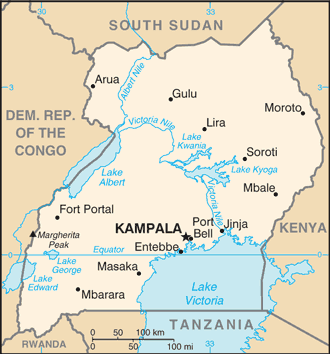
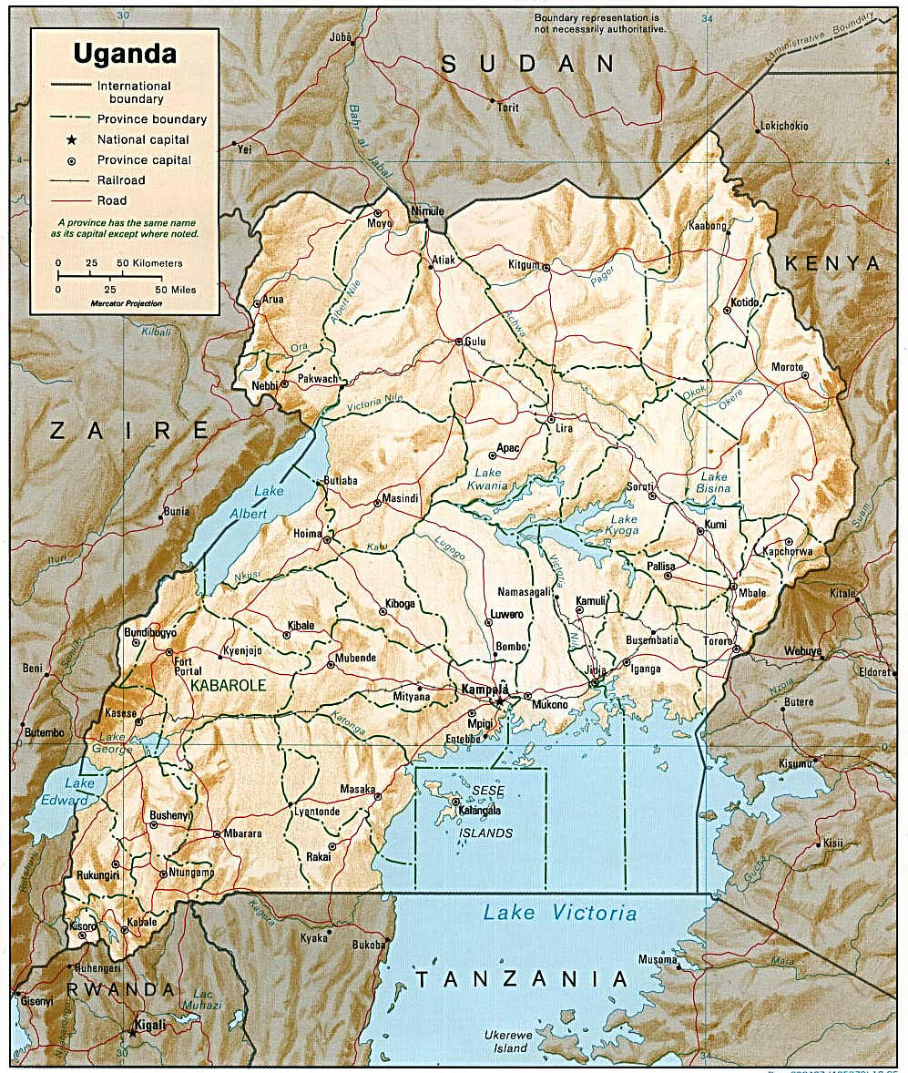
Tororo Airport is an airport serving the town of Tororo in the Eastern Region Eastern Region or East Region may refer to: * Eastern Region (Abu Dhabi): Al Ain *Eastern Region, Ghana *Eastern Region (Iceland) *Eastern Region, Nepal *Eastern Region, Nigeria * Eastern Region, Serbia * Eastern Region, Uganda * Eastern Region of ... of Uganda. Location The airport is about by road south of the town centre. This is about , by road, and , by air, north-east of Entebbe International Airport, the largest airport in Uganda. The coordinates of this airport are 00°40'53.0"N, 34°10'04.0"E (Latitude:0.681389; Longitude:34.167778). Overview The airport is at an average elevation of and has a single murram-surfaced runway (18/36), measuring long and wide. As of June 2015, the Civil Aviation Authority of Uganda had plans to develop this facility into a regional airport. See also * * * List of airports in Uganda * Transport in Uganda References External links Tororo Airport Pag ... [...More Info...] [...Related Items...] OR: [Wikipedia] [Google] [Baidu] |
Civil Aviation Authority Of Uganda
The Uganda Civil Aviation Authority (UCAA) is the government agency responsible for licensing, monitoring, and regulating civil aviation matters. It is administered by the Uganda Ministry of Works and Transport. Location The authority's head offices are at Entebbe International Airport, approximately , by road, south of Kampala, the capital and largest city of Uganda. The coordinates of the CAA headquarters are 0°02'23.0"N, 32°26'53.0"E (Latitude:0.039722; Longitude:32.448056). Overview The agency was created by an Act of Parliament in 1994 as a state agency of the Ministry of Transport, Housing and Communication. As of October 2016, it was under the Ministry of Works and Transport. The mandate of the UCAA is to coordinate and oversee Uganda's aviation industry, including licensing, regulation, air search and rescue, air traffic control, ownership of airports and aerodromes, and Ugandan and international aviation law. It also represents Uganda in an international capacity w ... [...More Info...] [...Related Items...] OR: [Wikipedia] [Google] [Baidu] |
Tororo
Tororo is a town in the Eastern Region of Uganda. It is the main municipal, administrative, and commercial center of Tororo District. History Tororo was garrisoned by the Uganda Army's Air and Sea Battalion during the Uganda–Tanzania War (1978–79). On 2 March 1979, rebels loyal to Milton Obote attacked the town, whereupon part of the garrison defected while the rest was routed. Tororo was recaptured by the Uganda Army in a counter-attack two days later, though many local civilians were displaced by the fighting. A few weeks later, however, Ugandan President Idi Amin's rule throughout Uganda collapsed and the garrison of Tororo reportedly mutinied yet again. In late April 1979, the Tanzania People's Defence Force's (TPDF) 19th Battalion, 208th Brigade, moved into Tororo. They encountered no resistance. The town was largely deserted and completely looted. Journalists Tony Avirgan and Martha Honey stated that the local UA garrison had fled the city, whereas Tom Cooper and ... [...More Info...] [...Related Items...] OR: [Wikipedia] [Google] [Baidu] |
Eastern Region, Uganda
The Eastern region is one of four regions in the country of Uganda. As of Uganda's 2014 census A census is the procedure of systematically acquiring, recording and calculating information about the members of a given population. This term is used mostly in connection with national population and housing censuses; other common censuses incl ..., the region's population was . Districts , the Eastern Region contained 32 districts: External links Google Map of the Eastern Region of Uganda References {{Districts of Uganda Regions of Uganda ... [...More Info...] [...Related Items...] OR: [Wikipedia] [Google] [Baidu] |
Uganda
}), is a landlocked country in East Africa East Africa, Eastern Africa, or East of Africa, is the eastern subregion of the African continent. In the United Nations Statistics Division scheme of geographic regions, 10-11-(16*) territories make up Eastern Africa: Due to the historical .... The country is bordered to the east by Kenya, to the north by South Sudan, to the west by the Democratic Republic of the Congo, to the south-west by Rwanda, and to the south by Tanzania. The southern part of the country includes a substantial portion of Lake Victoria, shared with Kenya and Tanzania. Uganda is in the African Great Lakes region. Uganda also lies within the Nile, Nile basin and has a varied but generally a modified equatorial climate. It has a population of around 49 million, of which 8.5 million live in the Capital city, capital and largest city of Kampala. Uganda is named after the Buganda kingdom, which encompasses a large portion of the south of the country, includi ... [...More Info...] [...Related Items...] OR: [Wikipedia] [Google] [Baidu] |
Entebbe International Airport
Entebbe International Airport is the only international airport in Uganda. It is located about southwest of the town of Entebbe, on the northern shores of Lake Victoria. This is approximately by road south-west of the central business district of Kampala, the capital city of Uganda. The headquarters of the Civil Aviation Authority of Uganda have been relocated to a new block off the airport highway (Entebbe–Kampala Expressway and Tunnel Road), but adjacent to the airport terminals. History The airport was opened by the British Colonial authorities. On 10 November 1951, the airport was formally reopened after its facilities had been extended. Runway 12/30 was now , in preparation for services by the de Havilland Comet. The new main terminal building of the airport was designed by Yugoslav Montenegrin architect Aleksandar Keković and built by Energoprojekt holding in 1972-1973 period. The Old Entebbe airport is used by Uganda's military forces. It was the scene of a host ... [...More Info...] [...Related Items...] OR: [Wikipedia] [Google] [Baidu] |
Murram
A gravel road is a type of unpaved road surfaced with gravel that has been brought to the site from a quarry or stream bed. They are common in less-developed nations, and also in the rural areas of developed nations such as Canada and the United States. In New Zealand, and other Commonwealth countries, they may be known as metal roads. They may be referred to as "dirt roads" in common speech, but that term is used more for unimproved roads with no surface material added. If well constructed and maintained, a gravel road is an all-weather road. Characteristics Construction Compared to sealed roads, which require large machinery to work and pour concrete or to lay and smooth a bitumen-based surface, gravel roads are easy and cheap to build. However, compared to dirt roads, all-weather gravel highways are quite expensive to build, as they require front loaders, dump trucks, graders, and roadrollers to provide a base course of compacted earth or other material, sometimes macada ... [...More Info...] [...Related Items...] OR: [Wikipedia] [Google] [Baidu] |
East African Business Week
''East African Business Week'' is a weekly Ugandan newspaper published in Kampala, Uganda's capital and largest city. It is the only exclusively business weekly published in the country. Location The newspaper headquarters and main office are located in ''Media Plaza Building'', at 133 Kira Road, in the Kamwokya neighborhood, in Kampala, about north of the city's central business district. The coordinates of the newspaper headquarters are 0°20'17.0"N, 32°35'05.0"E (Latitude:0.338053; Longitude:2.584730). Overview EABW maintains five bureaus, one in each of the five East African cities of Kampala, Nairobi, Kigali, Bujumbura, and Dar es Salaam. The newspaper covers investment and business news, together with health and technology news in Burundi, Kenya, Rwanda, Tanzania, and Uganda. It is published in English only. It has print and Internet versions. History The paper was founded in 2005. It is published by ''East Africa Business Weekly Limited''. See also * List of newspapers ... [...More Info...] [...Related Items...] OR: [Wikipedia] [Google] [Baidu] |
List Of Airports In Uganda
This is a list of airports in Uganda, sorted by location. Uganda is a landlocked country in East Africa. It is bordered on the east by Kenya, on the north by South Sudan, on the west by the Democratic Republic of the Congo, on the southwest by Rwanda, and on the south by Tanzania. The southern part of the country includes a substantial portion of Lake Victoria, which is also bordered by Kenya and Tanzania. Uganda's capital and largest city is Kampala. __TOC__ Airports Names shown in bold indicate the airport has scheduled passenger service on commercial airlines. These include Entebbe International Airport, plus three domestic airports where Kampala-based Eagle Air (Uganda), Eagle Air provides service: Arua Airport, Gulu Airport, and Moyo Airport. See also * Transport in Uganda * List of airports by ICAO code: H#HU - Uganda * Wikipedia: WikiProject Aviation/Airline destination lists: Africa#Uganda References Great Circle Mapper: Airports in Uganda- IATA and ICAO cod ... [...More Info...] [...Related Items...] OR: [Wikipedia] [Google] [Baidu] |
Transport In Uganda
Transport in Uganda refers to the transportation structure in Uganda. The country has an extensive network of paved and unpaved roads. Roadways As of 2017, according to the Uganda Ministry of Works and Transport, Uganda had about of roads, with approximately (4 percent) paved. Most paved roads radiate from Kampala, the country's capital and largest city. International highways The Lagos-Mombasa Highway, part of the Trans-Africa Highway and aiming to link East Africa and West Africa, passes through Uganda. This is complete only eastwards from the Uganda– DR Congo border to Mombasa, linking the African Great Lakes region to the sea. In East Africa, this roadway is part of the Northern Corridor. It cannot be used to reach West Africa because the route westwards across DR Congo to Bangui in the Central African Republic (CAR) is impassable after the Second Congo War and requires reconstruction. An alternative route (not part of the Trans-African network) to Bangui base ... [...More Info...] [...Related Items...] OR: [Wikipedia] [Google] [Baidu] |
Airports In Uganda
This is a list of airports in Uganda, sorted by location. Uganda is a landlocked country in East Africa. It is bordered on the east by Kenya, on the north by South Sudan, on the west by the Democratic Republic of the Congo, on the southwest by Rwanda, and on the south by Tanzania. The southern part of the country includes a substantial portion of Lake Victoria, which is also bordered by Kenya and Tanzania. Uganda's capital and largest city is Kampala. __TOC__ Airports Names shown in bold indicate the airport has scheduled passenger service on commercial airlines. These include Entebbe International Airport, plus three domestic airports where Kampala-based Eagle Air provides service: Arua Airport, Gulu Airport, and Moyo Airport. See also * Transport in Uganda * List of airports by ICAO code: H#HU - Uganda * Wikipedia: WikiProject Aviation/Airline destination lists: Africa#Uganda References Great Circle Mapper: Airports in Uganda- IATA and ICAO codes, coordinates, ... [...More Info...] [...Related Items...] OR: [Wikipedia] [Google] [Baidu] |
Tororo District
Tororo District is a district in the Eastern Region of Uganda. The town of Tororo hosts the district headquarters. Location Tororo District is bordered by Mbale District to the north, Manafwa District to the north-east, Kenya to the east, Busia District to the south, Bugiri District to the south-west, and Butaleja District to the north-west. Tororo, the largest town in the district and the location of the district headquarters, is approximately , east of Kampala Kampala (, ) is the capital and largest city of Uganda. The city proper has a population of 1,680,000 and is divided into the five political divisions of Kampala Central Division, Kawempe Division, Makindye Division, Nakawa Division, and Ruba ..., the capital and largest city of Uganda Population In 1991, the national population census estimated the population of the district at 285,300. The 2002 national census estimated the population at 379,400, with an annual population growth rate of approximately 2.7 perce ... [...More Info...] [...Related Items...] OR: [Wikipedia] [Google] [Baidu] |


