|
Threekingham Bar
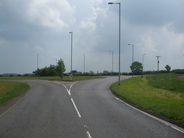
Threekingham Bar is the name given to interception of the A52 (Grantham to Boston) and A15 (Peterborough to Lincoln and Hull) roads, to the west of the village of Threekingham, in Lincolnshire, England The interception is arranged as a small modern roundabout. Both roads are single carriageway. The countryside is undulating, and the A52 descends into a valley to the west. The location is rural, with no human habitation. The name dates it to the turnpike era. The A52 approximately follows the route of Salters Way. An 18th-century mile post A milestone is a numbered marker placed on a route such as a road, railway line, canal or boundary. They can indicate the distance to towns, cities, and other places or landmarks; or they can give their position on the route relative to s ... is in the verge, south from the roundabout. See also * List of road junctions in the United Kingdom References North Kesteven District Road junctions in England Roads in L ... [...More Info...] [...Related Items...] OR: [Wikipedia] [Google] [Baidu] |
A52 Road (Great Britain)
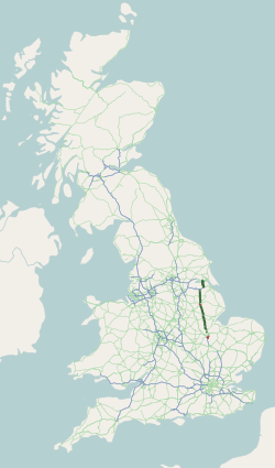
The A52 is a major road in the East Midlands, England. It runs east from a junction with the A53 at Newcastle-under-Lyme near Stoke-on-Trent via Ashbourne, Derby, Stapleford, Nottingham, West Bridgford, Bingham, Grantham, Boston and Skegness to the east Lincolnshire coast at Mablethorpe. It is approximately long. The mainly dual-carriageway stretch between The Pentagon Island in Derby and the Queen's Medical Centre in Nottingham was named ''Brian Clough Way'' in 2005 to honour the late Derby County and Nottingham Forest football manager Brian Clough. Historically the A52 used to start at Nantwich in Cheshire, but was renumbered to become the A500, the A531, and the B5500—the A500 sections later becoming unclassified. Route Newcastle-under-Lyme – Derby The road starts as ''Ryecroft'' from the roundabout with the A34 and B5367. It is dual carriageway until the next roundabout, forming part of the Newcastle ring road, with the A527 and A53. It passes the leisure ce ... [...More Info...] [...Related Items...] OR: [Wikipedia] [Google] [Baidu] |
Grantham
Grantham () is a market and industrial town in the South Kesteven district of Lincolnshire, England, situated on the banks of the River Witham and bounded to the west by the A1 road. It lies some 23 miles (37 km) south of the Lincoln and 22 miles (35 km) east of Nottingham. The population in 2016 was put at 44,580. The town is the largest settlement and the administrative centre of South Kesteven District. Grantham was the birthplace of the UK Prime Minister Margaret Thatcher. Isaac Newton was educated at the King's School. The town was the workplace of the UK's first warranted female police officer, Edith Smith in 1914. The UK's first running diesel engine was made there in 1892 and the first tractor in 1896. Thomas Paine worked there as an excise officer in the 1760s. The villages of Manthorpe, Great Gonerby, Barrowby, Londonthorpe and Harlaxton form outlying suburbs of the town. Etymology Grantham's name is first attested in the Domesday Book (1086); its orig ... [...More Info...] [...Related Items...] OR: [Wikipedia] [Google] [Baidu] |
Boston, Lincolnshire
Boston is a market town and inland port in the borough of the same name in the county of Lincolnshire, England. Boston is north of London, north-east of Peterborough, east of Nottingham, south-east of Lincoln, south-southeast of Hull and north-west of Norwich. Boston is the administrative centre of the wider Borough of Boston local government district. The town had a population of 35,124 at the 2001 census, while the borough had a population of 66,900 at the ONS mid-2015 estimates. Boston's most notable landmark is St Botolph's Church ("The Stump"), the largest parish church in England, which is visible from miles away across the flat lands of Lincolnshire. Residents of Boston are known as Bostonians. Emigrants from Boston named several other settlements around the world after the town, most notably Boston, Massachusetts in the United States. Name The name "Boston" is said to be a contraction of "Saint Botolph's town", "stone", or "'" (Old English, Old Norse an ... [...More Info...] [...Related Items...] OR: [Wikipedia] [Google] [Baidu] |
A15 Road (Great Britain)
The A15 is a major road in England. It runs north from Peterborough via Market Deeping, Bourne, Sleaford and Lincoln along a variety of ancient, Roman, and Turnpike alignments before it is interrupted at its junction with the M180 near Scawby. The road restarts east, and then continues north past Barton-upon-Humber, crossing the Humber on the Humber Bridge before terminating at Hessle near Kingston upon Hull. Driving conditions According to the AA, the route is long, and should take 2 hours. Norman Cross to Bourne takes 33 minutes, Bourne to Lincoln takes 46 minutes, and Lincoln to the Humber Bridge takes 54 minutes. A section of the A15 (between Scampton and the M180) provides the longest stretch of straight road in the UK. Route Peterborough The A15 is Peterborough's main connecting road from the south to the A1(M), joining near Stilton, at Norman Cross. It begins as ''London Road'' at junction 16 of the A1(M) with the B1043 (former A1) in Cambridgeshire and the ... [...More Info...] [...Related Items...] OR: [Wikipedia] [Google] [Baidu] |
Peterborough
Peterborough () is a cathedral city in Cambridgeshire, east of England. It is the largest part of the City of Peterborough unitary authority district (which covers a larger area than Peterborough itself). It was part of Northamptonshire until 1974, when county boundary change meant the city became part of Cambridgeshire instead. The city is north of London, on the River Nene which flows into the North Sea to the north-east. In 2020 the built-up area subdivision had an estimated population of 179,349. In 2021 the Unitary Authority area had a population of 215,671. The local topography is flat, and in some places, the land lies below sea level, for example in parts of the Fens to the east and to the south of Peterborough. Human settlement in the area began before the Bronze Age, as can be seen at the Flag Fen archaeological site to the east of the current city centre, also with evidence of Roman occupation. The Anglo-Saxon period saw the establishment of a monastery, Medeshams ... [...More Info...] [...Related Items...] OR: [Wikipedia] [Google] [Baidu] |
Lincoln, Lincolnshire
Lincoln () is a cathedral city, a non-metropolitan district, and the county town of Lincolnshire, England. In the 2021 Census, the Lincoln district had a population of 103,813. The 2011 census gave the urban area of Lincoln, including North Hykeham and Waddington, a population of 115,000. Roman ''Lindum Colonia'' developed from an Iron Age settlement on the River Witham. Landmarks include Lincoln Cathedral (English Gothic architecture; for over 200 years the world's tallest building) and the 11th-century Norman Lincoln Castle. The city hosts the University of Lincoln, Bishop Grosseteste University, Lincoln City FC and Lincoln United FC. Lincoln is the largest settlement in Lincolnshire, with the towns of Grimsby second largest and Scunthorpe third. History Earliest history: ''Lincoln'' The earliest origins of Lincoln can be traced to remains of an Iron Age settlement of round wooden dwellings, discovered by archaeologists in 1972, which have been dated to the first cen ... [...More Info...] [...Related Items...] OR: [Wikipedia] [Google] [Baidu] |
Kingston Upon Hull
Kingston upon Hull, usually abbreviated to Hull, is a port city and unitary authority in the East Riding of Yorkshire, England. It lies upon the River Hull at its confluence with the Humber Estuary, inland from the North Sea and south-east of York, the historic county town. With a population of (), it is the fourth-largest city in the Yorkshire and the Humber region after Leeds, Sheffield and Bradford. The town of Wyke on Hull was founded late in the 12th century by the monks of Meaux Abbey as a port from which to export their wool. Renamed ''Kings-town upon Hull'' in 1299, Hull had been a market town, military supply port, trading centre, fishing and whaling centre and industrial metropolis. Hull was an early theatre of battle in the English Civil Wars. Its 18th-century Member of Parliament, William Wilberforce, took a prominent part in the abolition of the slave trade in Britain. More than 95% of the city was damaged or destroyed in the blitz and suffered a perio ... [...More Info...] [...Related Items...] OR: [Wikipedia] [Google] [Baidu] |
Threekingham
Threekingham (sometimes ''Threckingham'' or ''Tricengham'') is a village in the North Kesteven district of Lincolnshire, England. The population of the civil parish at the 2011 census was 233. It is situated on the A52 Grantham to Boston road, south from Sleaford, and close to the A15 Threekingham Bar roundabout. Mareham Lane, the Roman Road aligned with King Street, crosses the A15 at Threekingham. History The name of the town means "home of Tric's people." ''Tric'' is a Brittonic personal name, though it is unclear whether Tric himself was a Briton or whether he was descended from Anglo-Saxon migrants but given a name borrowed from Celtic speakers who possibly lived nearby. Either way, Threekingham itself is a Germanic name, given by speakers of Old English. A folk etymology that developed in the later Anglo-Saxon period derives the name from "home of the three kings," supposedly because three Danish kings were buried there; however, this is incorrect. Threekingham ... [...More Info...] [...Related Items...] OR: [Wikipedia] [Google] [Baidu] |
Lincolnshire
Lincolnshire (abbreviated Lincs.) is a county in the East Midlands of England, with a long coastline on the North Sea to the east. It borders Norfolk to the south-east, Cambridgeshire to the south, Rutland to the south-west, Leicestershire and Nottinghamshire to the west, South Yorkshire to the north-west, and the East Riding of Yorkshire to the north. It also borders Northamptonshire in the south for just , England's shortest county boundary. The county town is Lincoln, where the county council is also based. The ceremonial county of Lincolnshire consists of the non-metropolitan county of Lincolnshire and the area covered by the unitary authorities of North Lincolnshire and North East Lincolnshire. Part of the ceremonial county is in the Yorkshire and the Humber region of England, and most is in the East Midlands region. The county is the second-largest of the English ceremonial counties and one that is predominantly agricultural in land use. The county is fourth-larg ... [...More Info...] [...Related Items...] OR: [Wikipedia] [Google] [Baidu] |
Salters Way , a dealer in chemical products
{{Disambiguation ...
Salter may refer to: *Salter (surname) *Salter (trap) *Salter Brecknell, a manufacturer of light commercial weighing scales, part of Avery Weigh-Tronix *Salter Housewares, a manufacturer of consumer weighing scales *Salters Steamers, a boating company on the River Thames, England *Worshipful Company of Salters, a Livery Companiy of the City of London See also *Psalter, a Book of Psalms *Drysalter Drysalters were dealers in a range of chemical products, including glue, varnish, dye and colourings. They might supply salt or chemicals for preserving food and sometimes also sold pickles, dried meat or related items. The name ''drysalter'' or '' ... [...More Info...] [...Related Items...] OR: [Wikipedia] [Google] [Baidu] |
Mile Post
A milestone is a numbered marker placed on a route such as a road, railway line, canal or boundary. They can indicate the distance to towns, cities, and other places or landmarks; or they can give their position on the route relative to some datum location. On roads they are typically located at the side or in a median or central reservation. They are alternatively known as mile markers, mileposts or mile posts (sometimes abbreviated MPs). A "kilometric point" is a term used in metricated areas, where distances are commonly measured in kilometres instead of miles. "Distance marker" is a generic unit-agnostic term. Milestones are installed to provide linear referencing points along the road. This can be used to reassure travellers that the proper path is being followed, and to indicate either distance travelled or the remaining distance to a destination. Such references are also used by maintenance engineers and emergency services to direct them to specific points where th ... [...More Info...] [...Related Items...] OR: [Wikipedia] [Google] [Baidu] |


