|
Tangjiashan Lake
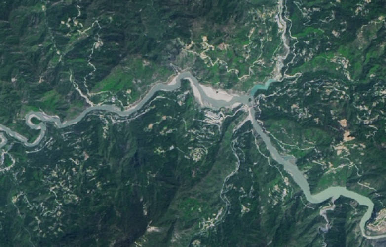
Tangjiashan Lake (, literally "Tang's Mountain landslide dam-created lake") is a landslide dam-created lake on the Jian River, which was formed by the 2008 Sichuan earthquake. Its name comes from the nearby mountain Tangjiashan. On May 24, 2008, the water level rose by in a single day, reaching a depth of , just below the barrier level. On June 9, 2008, more than 250,000 people had been evacuated from Mianyang in anticipation of the Tangjiashan Lake dam bursting. A similar lake in the same province formed 222 years earlier caused one of the worst landslide-related disasters in history. On June 10, 1786, a landslide dam on Sichuan's Dadu River, created by an earthquake ten days earlier, burst and caused a flood that extended 1400 km downstream and killed 100,000 people. A "relatively strong" aftershock on June 8, 2008, shook the massive earthquake-formed lake that has been threatening to flood more than 1 million people and triggered landslides in surrounding mountains. ... [...More Info...] [...Related Items...] OR: [Wikipedia] [Google] [Baidu] |
Beichuan Qiang Autonomous County
Beichuan Qiang Autonomous County (; Qiang: Juda Rrmea nyujugvexueaji xae) is a county under the jurisdiction of Mianyang City in northern Sichuan province, China. It is located in an ethnically diverse mountainous region of Sichuan. Its Chinese name literally means "North" (bei) "River" (chuan). Its new county seat is located at Yongchang after the 2008 Sichuan earthquake. Geography Beichuan County has an area of . The county varies in elevation from 540 to 4,769 meters in height. The county's major rivers, which include the , the , and the Pingtong River () belong to the larger Fu River watershed. History and culture The first administrative county of Beichuan was set up in 564 A.D. during the Northern Zhou dynasty. The Tang dynasty first created another county, Shiquan () inside the original Beichuan county in 634 A.D., then in 651 A.D. merged Beichuan county into Shiquan. The Republic of China changed the county name back to Beichuan in 1914 because there had been a ''Shi ... [...More Info...] [...Related Items...] OR: [Wikipedia] [Google] [Baidu] |
Beichuan
Beichuan Qiang Autonomous County (; Qiang: Juda Rrmea nyujugvexueaji xae) is a county under the jurisdiction of Mianyang City in northern Sichuan province, China. It is located in an ethnically diverse mountainous region of Sichuan. Its Chinese name literally means "North" (bei) "River" (chuan). Its new county seat is located at Yongchang after the 2008 Sichuan earthquake. Geography Beichuan County has an area of . The county varies in elevation from 540 to 4,769 meters in height. The county's major rivers, which include the , the , and the Pingtong River () belong to the larger Fu River watershed. History and culture The first administrative county of Beichuan was set up in 564 A.D. during the Northern Zhou dynasty. The Tang dynasty first created another county, Shiquan () inside the original Beichuan county in 634 A.D., then in 651 A.D. merged Beichuan county into Shiquan. The Republic of China changed the county name back to Beichuan in 1914 because there had been a ''Shi ... [...More Info...] [...Related Items...] OR: [Wikipedia] [Google] [Baidu] |
Megafloods
In geomorphology, an outburst flood—a type of megaflood—is a high-magnitude, low-frequency catastrophic flood involving the sudden release of a large quantity of water. During the last deglaciation, numerous glacial lake outburst floods were caused by the collapse of either ice sheets or glaciers that formed the dams of proglacial lakes. Examples of older outburst floods are known from the geological past of the Earth and inferred from geomorphological evidence on Mars. Landslides, lahars, and volcanic dams can also block rivers and create lakes, which trigger such floods when the rock or earthen barrier collapses or is eroded. Lakes also form behind glacial moraines or ice dams, which can collapse and create outburst floods. Definition and classification Megafloods are paleofloods (past floods) that involved rates of water flow larger than those in the historical record. They are studied through the sedimentary deposits and the erosional and constructional landforms that ... [...More Info...] [...Related Items...] OR: [Wikipedia] [Google] [Baidu] |
Bodies Of Water Of Sichuan
Bodies may refer to: * The plural of body * ''Bodies'' (2004 TV series), BBC television programme * Bodies (upcoming TV series), an upcoming British crime thriller limited series * "Bodies" (''Law & Order''), 2003 episode of ''Law & Order'' * Bodies: The Exhibition, exhibit showcasing dissected human bodies in cities across the globe * ''Bodies'' (novel), 2002 novel by Jed Mercurio * ''Bodies'', 1977 play by James Saunders (playwright) * ''Bodies'', 2009 book by British psychoanalyst Susie Orbach Music * ''Bodies'' (album), a 2021 album by AFI * ''Bodies'' (EP), a 2014 EP by Celia Pavey * "Bodies" (Drowning Pool song), 2001 hard rock song by Drowning Pool * "Bodies" (Sex Pistols song), 1977 punk rock song by the Sex Pistols * "Bodies" (Little Birdy song), 2007 indie rock song by Little Birdy * "Bodies" (Robbie Williams song), 2009 pop song by Robbie Williams * "Bodies", a song by Megadeth from ''Endgame Endgame, Endgames, End Game, End Games, or similar variations may re ... [...More Info...] [...Related Items...] OR: [Wikipedia] [Google] [Baidu] |
Lakes Of China
This is a list of lakes of China. Lakes of China include: See also {{Portal, China, Geography, Lakes *List of saltwater lakes of China *Five Lakes (China) *Lake Tianchi Monster Lake Tianchi Monster is the name given to what is said to be a lake monster that lives in Heaven Lake (known as ''Cheonji'' in Korean) located in the peak of Baekdu Mountain within the Baekdudaegan and Changbai mountain ranges encompassing Jilin ... External linksHangzhou West Lake description, photo gallery and maps*https://web.archive.org/web/20030808171438/http://www.hceis.com/ChinaBasic/Lakes/Lakes%20of%20China.htm ... [...More Info...] [...Related Items...] OR: [Wikipedia] [Google] [Baidu] |
Natural Disasters In China
Natural disasters in China are the result of several different natural hazards that affect the country according to its particular geographic and geologic features affecting both humans and animals. Perception of disasters Natural disasters reveal the traditional view of disasters as divine retribution: ''tian zai'' (天災), literally 'heavenly disaster'. In ancient beliefs, natural disasters were seen as Heaven's response to immoral human behaviour, whereby the conduct of different individuals carried different weights. While the behaviour of common people ranked last, the actions of bureaucrats had a greater effect. Given that in Imperial China the emperor's behaviour was believed to be the most important, popular belief was that the emperor should attempt to prevent disasters by ensuring his conduct was in following with moral codes – and if a disaster should occur, he was responsible for addressing the consequences. According to the Overseas Development Institute, the sta ... [...More Info...] [...Related Items...] OR: [Wikipedia] [Google] [Baidu] |
Landsat
The Landsat program is the longest-running enterprise for acquisition of satellite imagery of Earth. It is a joint NASA / USGS program. On 23 July 1972, the Earth Resources Technology Satellite was launched. This was eventually renamed to Landsat 1 in 1975. The most recent, Landsat 9, was launched on 27 September 2021. The instruments on the Landsat satellites have acquired millions of images. The images, archived in the United States and at Landsat receiving stations around the world, are a unique resource for global change research and applications in agriculture, cartography, geology, forestry, regional planning, surveillance and education, and can be viewed through the U.S. Geological Survey (USGS) "EarthExplorer" website. Landsat 7 data has eight spectral bands with spatial resolutions ranging from ; the temporal resolution is 16 days. Landsat images are usually divided into scenes for easy downloading. Each Landsat scene is about 115 miles long and 115 miles wide (or ... [...More Info...] [...Related Items...] OR: [Wikipedia] [Google] [Baidu] |
Beichuan Earthquake Museum
Beichuan Qiang Autonomous County (; Qiang language, Qiang: Juda Rrmea nyujugvexueaji xae) is a County (People's Republic of China), county under the jurisdiction of Mianyang City in northern Sichuan province, China. It is located in an ethnically diverse mountainous region of Sichuan. Its Chinese name literally means "North" (bei) "River" (chuan). Its new county seat is located at Yongchang, Sichuan, Yongchang after the 2008 Sichuan earthquake. Geography Beichuan County has an area of . The county varies in elevation from 540 to 4,769 meters in height. The county's major rivers, which include the , the , and the Pingtong River () belong to the larger Fu River (Sichuan), Fu River watershed. History and culture The first administrative county of Beichuan was set up in 564 Anno Domini, A.D. during the Northern Zhou dynasty. The Tang dynasty first created another county, Shiquan () inside the original Beichuan county in 634 A.D., then in 651 A.D. merged Beichuan county into Shiquan. ... [...More Info...] [...Related Items...] OR: [Wikipedia] [Google] [Baidu] |
Tangjiashan Lake 2018 Landsat , landslide dam-created lake formed by the 2008 Sichuan earthquake
{{Disambig ...
Tangjiashan may refer to: * Mount Tangjia, mountain in Sichuan, China * Tangjiashan Lake Tangjiashan Lake (, literally "Tang's Mountain landslide dam-created lake") is a landslide dam-created lake on the Jian River, which was formed by the 2008 Sichuan earthquake. Its name comes from the nearby mountain Tangjiashan. On May 24, 200 ... [...More Info...] [...Related Items...] OR: [Wikipedia] [Google] [Baidu] |
International Herald Tribune
The ''International Herald Tribune'' (''IHT'') was a daily English-language newspaper published in Paris, France for international English-speaking readers. It had the aim of becoming "the world's first global newspaper" and could fairly be said to have met that goal. It published under the name ''International Herald Tribune'' from 1967 to 2013. Early years In 1887, James Gordon Bennett Jr. created a Paris edition of his newspaper the '' New York Herald''. He called it the ''Paris Herald''. When Bennett Jr. died, the paper came under the control of Frank Munsey, who bought it along with its parent. In 1924, Munsey sold the paper to the family of Ogden Reid, owners of the ''New-York Tribune'', creating the '' New York Herald Tribune'', while the Paris edition became the ''Paris Herald Tribune''. By 1967, the paper was owned jointly by Whitney Communications, ''The Washington Post'' and ''The New York Times'', and became known as the ''International Herald Tribune'', or ''IHT'' ... [...More Info...] [...Related Items...] OR: [Wikipedia] [Google] [Baidu] |
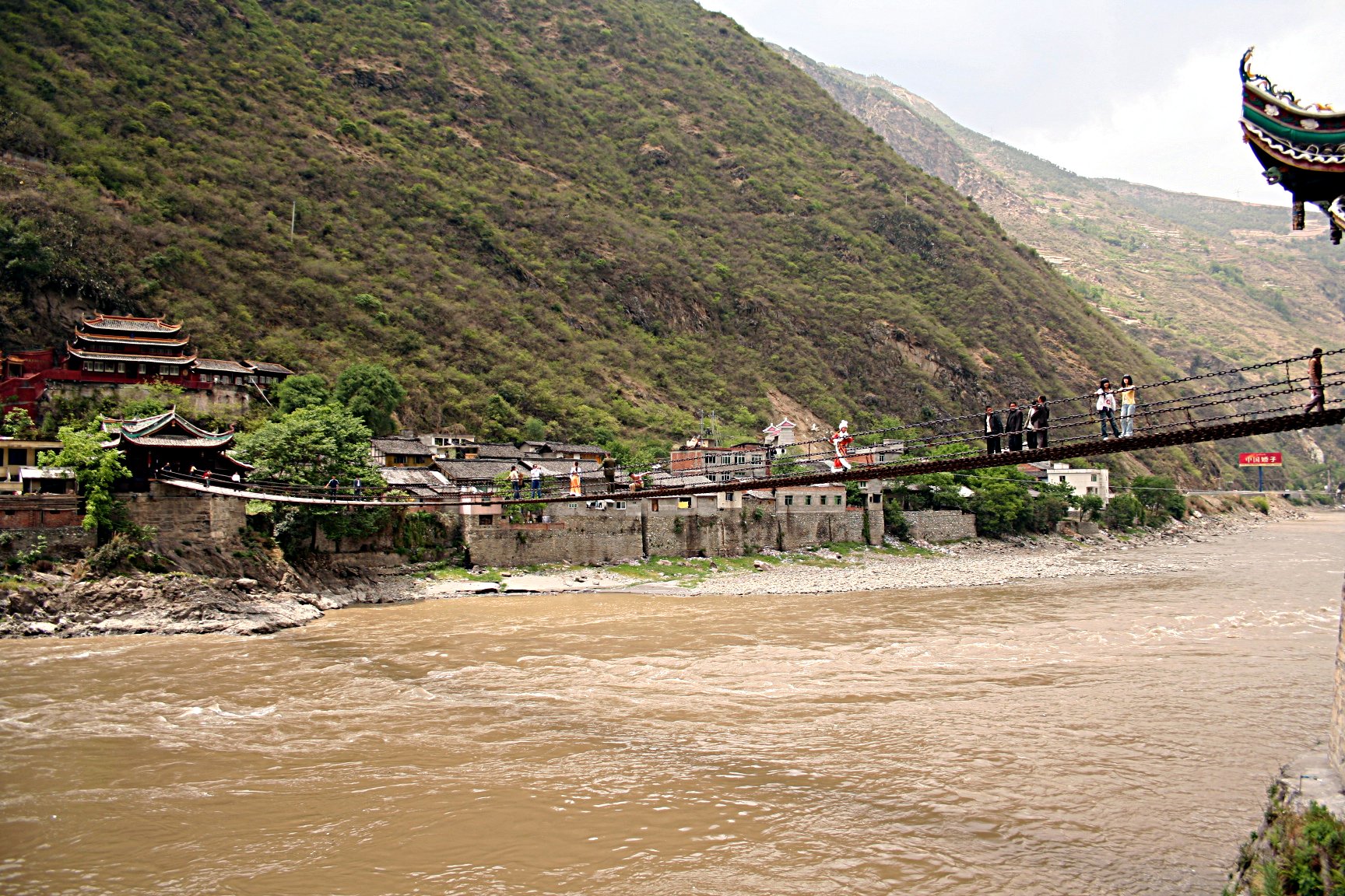
Dadu River (Sichuan)
The Dadu River (), known in Tibetan as the Gyelmo Ngul Chu, is a major river located primarily in Sichuan province, southwestern China. The Dadu flows from the eastern Tibetan Plateau into the Sichuan Basin where it joins with the Min River, a tributary of the Yangtze River. Measured from its geographic source, the Dadu is actually longer than the Min and thus forms the main stem of the Min River system. Shuangjiangkou Dam, expected to be the tallest dam in the world, is being built on the Dadu River. Geography Source The Dadu River originates, in name, in Danba and ends in Leshan where it meets the Min River. The true source of Dadu, and thus the entire Min River system, however, lies in Qinghai Province in the eastern Tibetan Plateau. In this region there are multiple headwaters of the Dadu with nearly identical lengths that have resulted in competing claims as the true source of the Dadu. In 2013, the China Academy of Sciences announced they had located the geographic ... [...More Info...] [...Related Items...] OR: [Wikipedia] [Google] [Baidu] |


