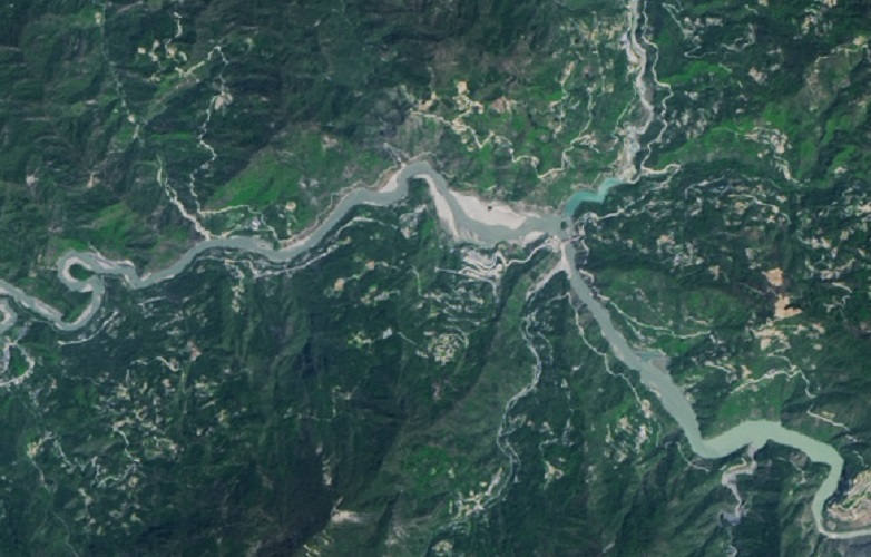
Tangjiashan Lake on:
[Wikipedia]
[Google]
[Amazon]
Tangjiashan Lake (, literally "Tang's Mountain landslide dam-created lake") is a
 The lake is now within the Beichuan Earthquake Museum.
landslide dam
A landslide dam or barrier lake is the natural damming of a river by some kind of landslide, such as a debris flow, rock avalanche or volcanic eruption. If the damming landslide is caused by an earthquake, it may also be called a quake lake. Some ...
-created lake on the Jian River, which was formed by the 2008 Sichuan earthquake. Its name comes from the nearby mountain
A mountain is an elevated portion of the Earth's crust, generally with steep sides that show significant exposed bedrock. Although definitions vary, a mountain may differ from a plateau in having a limited Summit (topography), summit area, and ...
Tangjiashan. On May 24, 2008, the water level rose by in a single day, reaching a depth of , just below the barrier level. On June 9, 2008, more than 250,000 people had been evacuated from Mianyang
Mianyang (; formerly known as Mienchow) is the second largest prefecture-level city of Sichuan province in Southwest China. Located in north-central Sichuan covering an area of consisting of Jiangyou, a county-level city, five counties, and thre ...
in anticipation of the Tangjiashan Lake dam
A dam is a barrier that stops or restricts the flow of surface water or underground streams. Reservoirs created by dams not only suppress floods but also provide water for activities such as irrigation, human consumption, industrial use ...
bursting.
A similar lake in the same province formed 222 years earlier caused one of the worst landslide-related disasters in history. On June 10, 1786, a landslide dam on Sichuan's Dadu River
The Dadu River (), known in Tibetan as the Gyelmo Ngul Chu, is a major river located primarily in Sichuan province, southwestern China. The Dadu flows from the eastern Tibetan Plateau into the Sichuan Basin where it joins with the Min River, a t ...
, created by an earthquake ten days earlier, burst and caused a flood that extended 1400 km downstream and killed 100,000 people.
A "relatively strong" aftershock on June 8, 2008, shook the massive earthquake-formed lake that has been threatening to flood more than 1 million people and triggered landslides in surrounding mountains. Soldiers used digging equipment, explosives, and even missiles to blast channels in the dam in an attempt to relieve the pressure behind it.
History
The flow from the sluice channel cut into the dam increased dramatically on June 10, 2008, going from 300 cubic metres/second to 7000 cubic metres/second in the span of four hours. The muddy waters flowed rapidly downstream causing flooding in the evacuated town ofBeichuan
Beichuan Qiang Autonomous County (; Qiang: Juda Rrmea nyujugvexueaji xae) is a county under the jurisdiction of Mianyang City in northern Sichuan province, China. It is located in an ethnically diverse mountainous region of Sichuan. Its Chinese n ...
and overtopping of dams.
Starting in June 2009, the lake was stabilized by strengthening the banks to prevent new landslides. In 2012, a discharge channel was finished, allowing the water level in the lake to be controlled.
In 2013 broken banks from a severe flood caused the lake's water to fall to 503 metres above sea level, 40 metres below its peak and 9 metres below its 2010 level. As water receded, the Xuanping town in the Beichuan Qiang Autonomous County
Beichuan Qiang Autonomous County (; Qiang: Juda Rrmea nyujugvexueaji xae) is a county under the jurisdiction of Mianyang City in northern Sichuan province, China. It is located in an ethnically diverse mountainous region of Sichuan. Its Chinese n ...
was revealed.
 The lake is now within the Beichuan Earthquake Museum.
 Landsat
The Landsat program is the longest-running enterprise for acquisition of satellite imagery of Earth. It is a joint NASA / USGS program. On 23 July 1972, the Earth Resources Technology Satellite was launched. This was eventually renamed to Lan ...
imagery from 2018 showed that the lake's size was greatly reduced due to natural erosion of the barrier and filling of the lake with sediment.
As of 2018, there were plans to convert the lake to a controlled hydropower reservoir.
See also
*Natural disasters in China
Natural disasters in China are the result of several different natural hazards that affect the country according to its particular geographic and geologic features affecting both humans and animals.
Perception of disasters
Natural disasters rev ...
References
{{Lakes of China Lakes of China 2008 Sichuan earthquake Bodies of water of Sichuan Megafloods Landslide-dammed lakes Landslides in China Landslides in 2008