|
Takeo, Saga
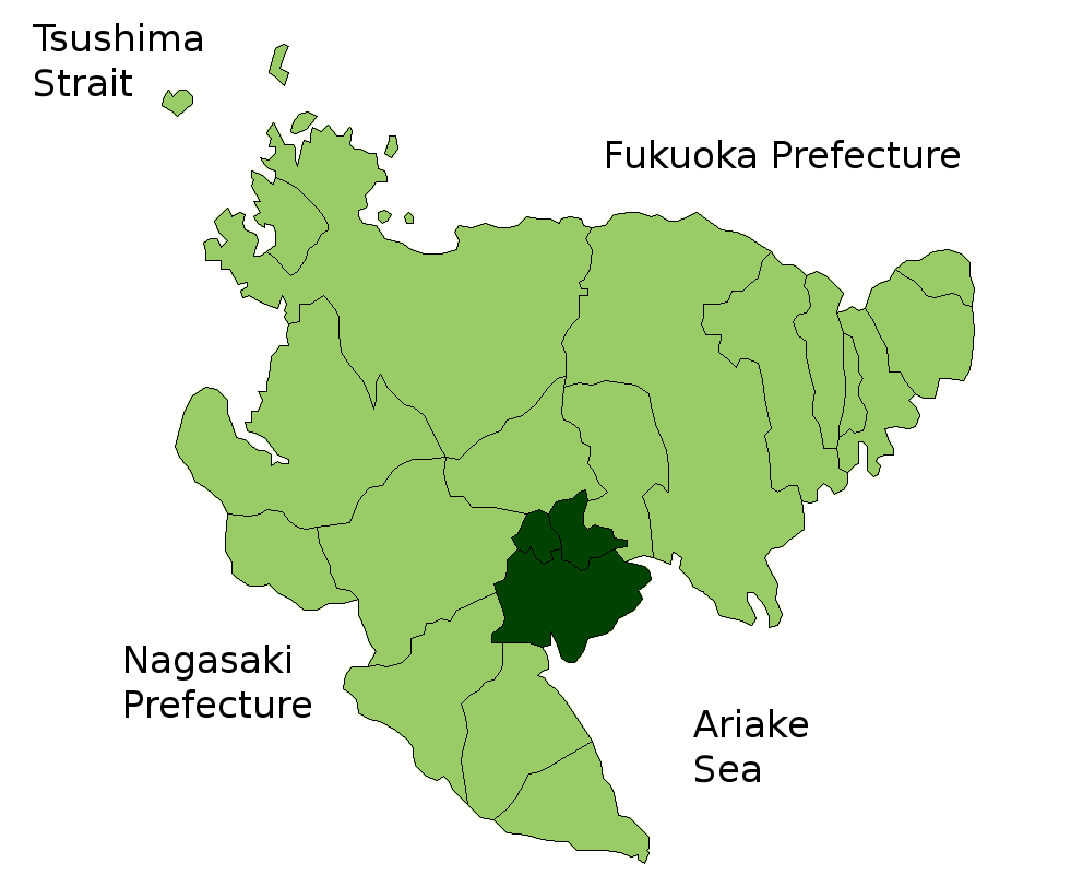
is a city located in Saga Prefecture on the island of Kyushu, Japan. In 2011, the city government was the first in Japan to switch to using Facebook for its website. As of October 1, 2016, the city has an estimated population of 48,845 and a population density of 257 persons per km². The total area is 195.44 km². On March 1, 2006, the towns of Kitagata and Yamauchi (both from Kishima District) were merged into Takeo. Geography Takeo is located in the western part of Saga Prefecture. It is approximately west of Saga City and approximately east of Sasebo. Takeo has a complex topography including mountains, mountain basins and riverside plains. *Mountains: Mt. Mifune (210 m), Mt. Hachiman (764 m), Mt. Bi (518 m), Mt. Jinroku (447 m) *Rivers: Rokkaku River, Shiomi River, Yamanaka River Adjoining municipalities *Saga Prefecture ** Arita **Imari **Karatsu ** Ōmachi ** Shiroishi **Taku ** Ureshino *Nagasaki Prefecture **Hasami History *1889-04-01 - The modern municip ... [...More Info...] [...Related Items...] OR: [Wikipedia] [Google] [Baidu] |
Cities Of Japan
A is a local administrative unit in Japan. Cities are ranked on the same level as and , with the difference that they are not a component of . Like other contemporary administrative units, they are defined by the Local Autonomy Law of 1947. City status Article 8 of the Local Autonomy Law sets the following conditions for a municipality to be designated as a city: *Population must generally be 50,000 or greater (原則として人口5万人以上) *At least 60% of households must be established in a central urban area (中心市街地の戸数が全戸数の6割以上) *At least 60% of households must be employed in commerce, industry or other urban occupations (商工業等の都市的業態に従事する世帯人口が全人口の6割以上) *Any other conditions set by prefectural ordinance must be satisfied (他に当該都道府県の条例で定める要件を満たしていること) The designation is approved by the prefectural governor and the Minister for Intern ... [...More Info...] [...Related Items...] OR: [Wikipedia] [Google] [Baidu] |
Kishima District, Saga
is a district located in Saga Prefecture, Japan. As of February 1, 2009, the district has an estimated population of 45,085 and a density Density (volumetric mass density or specific mass) is the substance's mass per unit of volume. The symbol most often used for density is ''ρ'' (the lower case Greek letter rho), although the Latin letter ''D'' can also be used. Mathematicall ... of 318 persons per km2. The total area is 135.40 km2. Municipalities * Kōhoku * Ōmachi * Shiroishi History {{Authority control Districts in Saga Prefecture ... [...More Info...] [...Related Items...] OR: [Wikipedia] [Google] [Baidu] |
Hasami, Nagasaki
is a town located in Higashisonogi District, Nagasaki Prefecture, Japan. It is known, along with neighboring Arita, Saga Prefecture for its china manufacturing. As of 2 September 2021, the town has an estimated population of 14,511. The total area is 56.00 km2. Geography Hasami is located within the central part of Nagasaki prefecture, which is about 20 kilometers from central Sasebo. It is the only landlocked town in the prefecture. Surrounding municipalities * Nagasaki Prefecture ** Sasebo ** Kawatana * Saga Prefecture ** Takeo ** Ureshino ** Arita Culture Hasami is best known for Hasami ware, a type of Japanese porcelain dating back 400 years. The techniques were brought to the Hasami area by Korean ceramicist Yi Sam-pyeong, also the creator of Arita ware from nearby Arita. Hasami ware is distinct from Arita ware, but is often confused as pieces were shipped out of Arita or the neighboring port of Imari. Seventeen kilns and pottery houses are active in ... [...More Info...] [...Related Items...] OR: [Wikipedia] [Google] [Baidu] |
Nagasaki Prefecture
is a prefecture of Japan located on the island of Kyūshū. Nagasaki Prefecture has a population of 1,314,078 (1 June 2020) and has a geographic area of 4,130 km2 (1,594 sq mi). Nagasaki Prefecture borders Saga Prefecture to the northeast. Nagasaki is the capital and largest city of Nagasaki Prefecture, with other major cities including Sasebo, Isahaya, and Ōmura. Nagasaki Prefecture is located in western Kyūshū with a territory consisting of many mainland peninsulas centered around Ōmura Bay, as well as islands and archipelagos including Tsushima and Iki in the Korea Strait and the Gotō Islands in the East China Sea. Nagasaki Prefecture is known for its century-long trading history with the Europeans and as the sole place of direct trade and exchange between Japan and the outside world during the '' Sakoku'' period. Nagasaki Prefecture is home to several of the Hidden Christian Sites in the Nagasaki Region which have been declared a UNESCO World Heritage Site. ... [...More Info...] [...Related Items...] OR: [Wikipedia] [Google] [Baidu] |
Ureshino, Saga
is a city located in the western part of Saga Prefecture on the island of Kyushu, Japan. The modern city of Ureshino was formed on January 1, 2006, by the merger of the former town of Ureshino, absorbing the town of Shiota (both from Fujitsu District). Ureshino is locally known for the green tea grown there and its hot spring resorts. Adjoining municipalities *Saga Prefecture ** Kashima ** Takeo ** Shiroishi *Nagasaki Prefecture **Hasami ** Higashisonogi ** Kawatana **Ōmura History *1889-04-01 – The modern municipal system was established. The current city region is occupied by 6 villages (Gochōda, Higashiureshino, Kuma, Nishiureshino, Shiota and Yoshida). *1918-10-05 – Shiota was elevated to town status. *1929-04-22 – Nishiureshino was elevated to town status and was renamed Ureshino. *1933-04-01 – Higashiureshino was incorporated into Ureshino. *1955-04-01 – Yoshida was incorporated into Ureshino. *1956-09-01 – Gochōda and Kuma were incorporated into Shiota. ... [...More Info...] [...Related Items...] OR: [Wikipedia] [Google] [Baidu] |
Taku, Saga
is a city located in Saga Prefecture on the island of Kyushu, Japan. The city was founded on May 1, 1954 through the merger of several towns and villages. As of March 1, 2017, the city has an estimated population of 19,202 and a population density of 200 persons per km². The total area is 96.93 km². Taku joined the UNESCO Global Network of Learning Cities in 2017. Education Elementary Schools *Hokubu Elementary School *Midori-ga-Oka Elementary School *Tobu Elementary School *Nosho Elementary School *Nanbu Elementary School *Nankei Elementary School *Chubu Elementary School *Seibu Elementary School Junior High Schools *Tobu Junior High School *Seikei Junior High School *Chuou Junior High School Senior High Schools *Taku Senior High School Tourism and culture Taku Seibyō is a Confucian temple built in 1708 by Lord Shigefumi. This is one of the oldest Confucian temples in Japan and has been designated as an Important Cultural Asset. It is also the oldest original s ... [...More Info...] [...Related Items...] OR: [Wikipedia] [Google] [Baidu] |
Shiroishi, Saga
is a town located in south-central Saga Prefecture, Japan, in Kishima District. It is known for its vast reclaimed land and tidal flats of the Ariake Sea. As of October 1, 2016, the town has an estimated population of 23,606. On January 1, 2005 Shiroshi absorbed the towns of Fukudomi and Ariake, all from Kishima District, to become the new and expanded town of Shiroshi. Geography Terrain Located in the Saga plains, Shiroishi is bordered by the Ariake Sea to the southeast. The port of Suminoe Bay, in the mouth of the Rokkaku River, has the largest tidal range in Japan with a maximum of about 6m at spring tide. * Mountains: Mt. Kishima (345m), Mt. Inuyama (342m), Mt. Shiraiwa (340m), Mt. Iimori (318m) * Rivers: Rokkaku River, Shioda River, Marie River, Tadae River * Lakes: Nuinoike, Kasegawaike * 85% of the total area of cultivated land is farmland. Climate *Annual Mean Air Temperature: *Annual Mean Precipitation: about Adjoining Cities and Municipalities * Kashima ... [...More Info...] [...Related Items...] OR: [Wikipedia] [Google] [Baidu] |
Ōmachi, Saga
is a town located in Kishima District, Saga Prefecture, Japan. As of October 1, 2016, the town has an estimated population of 6,680. Geography *Mountains: The northern part of town gradually becomes mountainous. *Rivers: Rokkaku River *Lakes: The northern, mountainous part of town is dotted with ponds. Adjoining Cities and Municipalities *Saga Prefecture **Taku ** Takeo ** Shiroishi ** Kōhoku History *April 1, 1889 - The village of Fukumo merges with the village of Ōmachi. *January 1, 1936 - The village of Ōmachi gains town status. Economy *Agricultural Products: Rice, barley, cucumbers, strawberries, and chickens. *There was a coal mine which operated until 1960. Education *Saga Prefectural Business High School *Ōmachi Junior High School *Ōmachi Elementary School Transportation Air *The nearest airport is Saga Airport Rail *JR Kyushu **Sasebo Line *** Ōmachi Station Road * Expressways: None *National Highways: Route 34 * Prefectural Roads: Saga Prefecture Route ... [...More Info...] [...Related Items...] OR: [Wikipedia] [Google] [Baidu] |
Karatsu, Saga
is a city located in Saga Prefecture on the island of Kyushu, Japan. Its name, formed from the Japanese word roots 唐 ''kara'' (China, or continental East Asia in general), and 津 ''tsu'' (port), signifies its historical importance as an ancient trading port between Japan with China and Korea. The central area of Karatsu, which does not include the former cities and villages of Higashimatsuura District, has a population of 78,386. As of January 1, 2020, the city had an estimated population of 117,663 and a population density of 241 persons per km2. The total area is 487.59 km2. On January 1, 2005, the towns of Chinzei, Hamatama, Hizen, Kyūragi, Ōchi, Yobuko and the village of Kitahata (all from Higashimatsuura District) were merged into Karatsu. On January 1, 2006, the village of Nanayama (from Higashimatsuura District) was merged into Karatsu. Geography Due to its proximity to mainland Asia, Karatsu has long been known as a stopover to Korea and China. ... [...More Info...] [...Related Items...] OR: [Wikipedia] [Google] [Baidu] |
Imari, Saga
is a city located in Saga Prefecture on the island of Kyushu, Japan. Imari is most notable because of Imari porcelain, which is the European collectors' name for Japanese porcelain wares made in the town of Arita, Saga Prefecture. The porcelain was exported from the port of Imari specifically for the European export trade. As of October 1, 2016, the city has an estimated population of 54,907 and a population density of 220 persons per km2. The total area is 254.99 km2. Geography Imari is located in the western part of Saga Prefecture. The city center is located around the mouth of the Imari River. * Mountains: Mt. Hachiman (764 m), Mt. Seira (599 m), Mt. Eboshi (597 m) *Rivers: Matsuura River, Imari River, Hata River, Kurōtake River, Arita River Adjoining municipalities *Saga Prefecture ** Arita **Karatsu ** Takeo *Nagasaki Prefecture ** Sasebo ** Matsuura Climate History During the Edo period this region flourished due to the export of ceramics and porcelain. High qu ... [...More Info...] [...Related Items...] OR: [Wikipedia] [Google] [Baidu] |
Arita, Saga
is a town located in Nishimatsuura District, Saga Prefecture, Japan. It is known for producing Arita porcelain, one of the traditional handicrafts of Japan. It also holds the largest ceramic fair in Western Japan, the Arita Ceramic Fair. This event is held from April 29 to May 5 ( Golden Week) every year and has thousands of stores and stalls lining the six-kilometre long main street. On March 1, 2006 the town of Nishiarita, from Nishimatsuura District, was merged into Arita. Geography Arita is located in the western part of Saga Prefecture, bordering Nagasaki Prefecture from its southwest to western sides. About 70% of the town is forest and mountains. Neighbouring municipalities *Saga Prefecture **Imari ** Takeo History Arita was one of the first sites in Japan to produce porcelain, Arita ware. The discovery of porcelain stone is attributed to a Korean potter named Kanagae Sambe, although most historians consider this a legend. *April 1, 1889 – The modern municip ... [...More Info...] [...Related Items...] OR: [Wikipedia] [Google] [Baidu] |
River
A river is a natural flowing watercourse, usually freshwater, flowing towards an ocean, sea, lake or another river. In some cases, a river flows into the ground and becomes dry at the end of its course without reaching another body of water. Small rivers can be referred to using names such as creek, brook, rivulet, and rill. There are no official definitions for the generic term river as applied to geographic features, although in some countries or communities a stream is defined by its size. Many names for small rivers are specific to geographic location; examples are "run" in some parts of the United States, "burn" in Scotland and northeast England, and "beck" in northern England. Sometimes a river is defined as being larger than a creek, but not always: the language is vague. Rivers are part of the water cycle. Water generally collects in a river from precipitation through a drainage basin from surface runoff and other sources such as groundwater recharge, spr ... [...More Info...] [...Related Items...] OR: [Wikipedia] [Google] [Baidu] |


