|
Târnava-Mică County
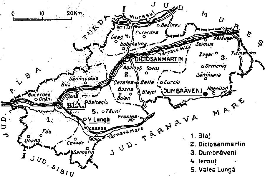
Târnava-Mică County was a county (Romanian: '' județ'') in the Kingdom of Romania, the successor to Kis-Küküllő County of the Kingdom of Hungary. Its capital was Diciosânmartin (now Târnăveni, in Mureș County) until 1926, and afterwards at Blaj. Geography Târnava-Mică County covered 2,081 km2 and was located in central part of Greater Romania, in the centre of Transylvania. Currently, the territory that comprised the greater part of Târnava-Mică County is now part of Sibiu County, Mureș County, and Alba County. Its borders were as follows: Turda County to the northwest, Mureș County to the northeast, Alba County to the west, Sibiu County and Târnava-Mare County to the south, and Odorhei County to the east. History Prior to World War I, the territory of the county belonged to Austria-Hungary and was identical with the Kis-Küküllő County of the Kingdom of Hungary. The territory of Târnava-Mică County was transferred to Romania from Hungary as succe ... [...More Info...] [...Related Items...] OR: [Wikipedia] [Google] [Baidu] |
Countries Of The World
The following is a list providing an overview of sovereign states around the world with information on their status and recognition of their sovereignty. The 206 listed states can be divided into three categories based on membership within the United Nations System: 193 member states of the United Nations, UN member states, 2 United Nations General Assembly observers#Present non-member observers, UN General Assembly non-member observer states, and 11 other states. The ''sovereignty dispute'' column indicates states having undisputed sovereignty (188 states, of which there are 187 UN member states and 1 UN General Assembly non-member observer state), states having disputed sovereignty (16 states, of which there are 6 UN member states, 1 UN General Assembly non-member observer state, and 9 de facto states), and states having a political status of the Cook Islands and Niue, special political status (2 states, both in associated state, free association with New Zealand). Compi ... [...More Info...] [...Related Items...] OR: [Wikipedia] [Google] [Baidu] |
Plasă
''Plasă'' (, plural ''plăși'' ) was a territorial division unit of Romania, ranking below county ('' județ'') and above commune. It was headed by a '' Pretor'', appointed by the county Prefect. The institution headed by the Pretor was called ''Pretură''. The division of counties into ''plăși'' was used starting from the rule of Carol I as ''Domnitor'', throughout the existence of a Romanian Kingdom, and during the first two years of the Romanian People's Republic, until they were replaced in 1950 by raions, following the Soviet The Soviet Union,. officially the Union of Soviet Socialist Republics. (USSR),. was a List of former transcontinental countries#Since 1700, transcontinental country that spanned much of Eurasia from 1922 to 1991. A flagship communist state, ... system. In 1938, the country's 71 ''județe'' were divided into 429 ''plăși''. Petre Mihai Băcanu"Cum ar trebui să arate harta redesenată a României?" March 11, 2010; accessed February 17, 2013 ... [...More Info...] [...Related Items...] OR: [Wikipedia] [Google] [Baidu] |
Dumbrăveni
Dumbrăveni (before 1945 ''Ibașfalău''; german: Elisabethstadt; Saxon dialect: ''Eppeschdorf''; hu, Erzsébetváros) is a town in the north of Sibiu County, in the centre of Transylvania, central Romania. The town administers two villages, Ernea (''Ehrgang''; ''Argung''; ''Szászernye'') and Șaroș pe Târnave (''Scharosch an der kokel''; ''Šuerš''; ''Szászsáros''). Geography Dumbrăveni lies on the banks of the river Târnava Mare, east from the city of Mediaș, the second largest city in the county, and northeast of Sibiu, the county seat. It is situated on the Transylvanian Plateau, on the border with Mureș County, midway between Mediaș and Sighișoara. The town is crossed on its southern edge by National Road , which connects Sibiu to Sighișoara. There is also a train station that serves Line 300 of the CFR network, which connects Bucharest with the Hungarian border near Oradea. The Șaroș gas field is located on the territory of Dumbrăveni. Demographic ... [...More Info...] [...Related Items...] OR: [Wikipedia] [Google] [Baidu] |
1938 Map Of Interwar County Tarnava Mica
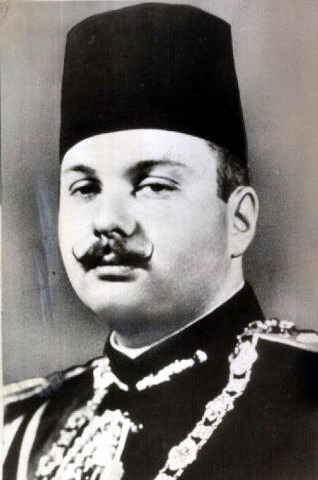
Events January * January 1 ** The new constitution of Estonia enters into force, which many consider to be the ending of the Era of Silence and the authoritarian regime. ** State-owned railway networks are created by merger, in France ( SNCF) and the Netherlands (Nederlandse Spoorwegen – NS). * January 20 – King Farouk of Egypt marries Safinaz Zulficar, who becomes Queen Farida, in Cairo. * January 27 – The Honeymoon Bridge at Niagara Falls, New York, collapses as a result of an ice jam. February * February 4 ** Adolf Hitler abolishes the War Ministry and creates the Oberkommando der Wehrmacht (High Command of the Armed Forces), giving him direct control of the German military. In addition, he dismisses political and military leaders considered unsympathetic to his philosophy or policies. General Werner von Fritsch is forced to resign as Commander of Chief of the German Army following accusations of homosexuality, and replaced by General Walth ... [...More Info...] [...Related Items...] OR: [Wikipedia] [Google] [Baidu] |
Regions Of The People's Republic Of Romania
The regions represented the result of a Soviet-inspired experiment regarding the administrative and territorial organisation of the Romanian People's Republic (later Socialist Republic of Romania) between 1950 and 1968. See also: Administrative divisions of the People's Republic of Romania. Regions of 1950 *Regiunea Arad (Ar.) * Regiunea Argeș (Ptș.) * Regiunea Bacău (Bc.) *Regiunea Baia Mare (B.Mr.) * Regiunea Bârlad (Bd.) * Regiunea Bihor (Ord.) * Regiunea Botoșani (Bt.) * Regiunea București (R.B.) * Regiunea Buzău (Bz.) * Regiunea Cluj (Clj.) * Regiunea Constanța (Cța.) *Regiunea Dolj (Cv.) * Regiunea Galați (Gl.) * Regiunea Gorj (Tg.J.) * Regiunea Hunedoara (Dv.) * Regiunea Ialomița (Cl.) * Regiunea Iași (Iș.) * Regiunea Mureș (Tg.M.) * Regiunea Prahova (Pl.) * Regiunea Putna (Fș.) * Regiunea Rodna (Btr.) * Regiunea Satu Mare (St.M.) * Regiunea Severin (Lgș.) * Regiunea Sibiu (Sb.) *Regiunea Stalin (O.S.) *Regiunea Suceava (Sv.) * Regiunea Teleorman (R.Vd.) * R ... [...More Info...] [...Related Items...] OR: [Wikipedia] [Google] [Baidu] |
Paris Peace Treaties, 1947
The Paris Peace Treaties (french: Traités de Paris) were signed on 10 February 1947 following the end of World War II in 1945. The Paris Peace Conference lasted from 29 July until 15 October 1946. The victorious wartime Allied powers (principally the United Kingdom, Soviet Union, United States and France) negotiated the details of peace treaties with Italy, Romania, Hungary, Bulgaria, and Finland. The treaties allowed the defeated Axis powers to resume their responsibilities as sovereign states in international affairs and to qualify for membership in the United Nations.They each joined the United Nations on 14 December 1955. The settlement elaborated in the peace treaties included payment of war reparations, commitment to minority rights, and territorial adjustments including the end of the Italian colonial empire in Africa, Greece, and Albania, as well as changes to the Italian–Yugoslav, Hungarian–Czechoslovak, Soviet–Romanian, Hungarian–Romanian, French–Italian ... [...More Info...] [...Related Items...] OR: [Wikipedia] [Google] [Baidu] |
Second Vienna Award
The Second Vienna Award, also known as the Vienna Diktat, was the second of two territorial disputes that were arbitrated by Nazi Germany and Fascist Italy. On 30 August 1940, they assigned the territory of Northern Transylvania, including all of Maramureș and part of Crișana, from Romania to Hungary. Background After World War I, the multiethnic Kingdom of Hungary was divided by the 1920 Treaty of Trianon to form several new nation states, but Hungary noted that the new state borders did not follow ethnic boundaries. The new nation state of Hungary was about a third the size of prewar Hungary, and millions of ethnic Hungarians were left outside the new Hungarian borders. Many historically-important areas of Hungary were assigned to other countries, and the distribution of natural resources was uneven. The various non-Hungarian populations generally saw the treaty as justice for their historically-marginalised nationalities, but the Hungarians considered the treaty to have ... [...More Info...] [...Related Items...] OR: [Wikipedia] [Google] [Baidu] |
Northern Transylvania
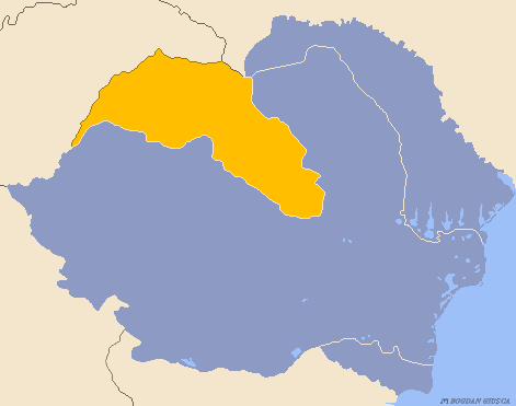
Northern Transylvania ( ro, Transilvania de Nord, hu, Észak-Erdély) was the region of the Kingdom of Romania that during World War II, as a consequence of the August 1940 territorial agreement known as the Second Vienna Award, became part of the Kingdom of Hungary. With an area of , the population was largely composed of both ethnic Romanians and Hungarians. In October 1944, Soviet and Romanian forces gained control of the territory, and by March 1945 Northern Transylvania returned to Romanian administration. After the war, this was confirmed by the Paris Peace Treaties of 1947. Background The region has a varied history. It was once the nucleus of the Kingdom of Dacia (82 BC–106 AD). In 106 AD the Roman Empire conquered the territory, systematically exploiting its resources. After the Roman legions withdrew in 271 AD, it was overrun by a succession of various tribes, bringing it under the control of the Carpi, Visigoths, Huns, Gepids, Avars, and Slavs. During the 9th ... [...More Info...] [...Related Items...] OR: [Wikipedia] [Google] [Baidu] |
Treaty Of Trianon
The Treaty of Trianon (french: Traité de Trianon, hu, Trianoni békeszerződés, it, Trattato del Trianon) was prepared at the Paris Peace Conference (1919–1920), Paris Peace Conference and was signed in the Grand Trianon château in Versailles on 4 June 1920. It formally ended World War I between most of the Allies of World War I and the Kingdom of Hungary. French diplomats played the major role in designing the treaty, with a view to establishing a French-led coalition of the newly formed states. It regulated the status of the Kingdom of Hungary and defined its borders generally within the #Borders of Hungary, ceasefire lines established in November–December 1918 and left Hungary as a Landlocked country, landlocked state that included , 28% of the that had constituted the pre-war Lands of the Crown of Saint Stephen, Kingdom of Hungary (the Hungarian half of the Austria-Hungary, Austro-Hungarian monarchy). The truncated kingdom had a population of 7.6 million, 36% ... [...More Info...] [...Related Items...] OR: [Wikipedia] [Google] [Baidu] |
Austria-Hungary
Austria-Hungary, often referred to as the Austro-Hungarian Empire,, the Dual Monarchy, or Austria, was a constitutional monarchy and great power in Central Europe between 1867 and 1918. It was formed with the Austro-Hungarian Compromise of 1867 in the aftermath of the Austro-Prussian War and was dissolved shortly after its defeat in the First World War. Austria-Hungary was ruled by the House of Habsburg and constituted the last phase in the constitutional evolution of the Habsburg monarchy. It was a multinational state and one of Europe's major powers at the time. Austria-Hungary was geographically the second-largest country in Europe after the Russian Empire, at and the third-most populous (after Russia and the German Empire). The Empire built up the fourth-largest machine building industry in the world, after the United States, Germany and the United Kingdom. Austria-Hungary also became the world's third-largest manufacturer and exporter of electric home appliances, ... [...More Info...] [...Related Items...] OR: [Wikipedia] [Google] [Baidu] |
World War I
World War I (28 July 1914 11 November 1918), often abbreviated as WWI, was one of the deadliest global conflicts in history. Belligerents included much of Europe, the Russian Empire, the United States, and the Ottoman Empire, with fighting occurring throughout Europe, the Middle East, Africa, the Pacific, and parts of Asia. An estimated 9 million soldiers were killed in combat, plus another 23 million wounded, while 5 million civilians died as a result of military action, hunger, and disease. Millions more died in genocides within the Ottoman Empire and in the 1918 influenza pandemic, which was exacerbated by the movement of combatants during the war. Prior to 1914, the European great powers were divided between the Triple Entente (comprising France, Russia, and Britain) and the Triple Alliance (containing Germany, Austria-Hungary, and Italy). Tensions in the Balkans came to a head on 28 June 1914, following the assassination of Archduke Franz Ferdin ... [...More Info...] [...Related Items...] OR: [Wikipedia] [Google] [Baidu] |


