|
Tyszowce
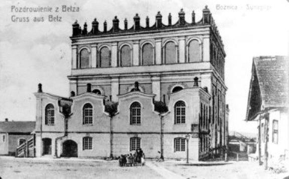
Tyszowce (; yi, טישעוויץ, Tishevitz; uk, Тишо́вце, Tyshóvtse) is a town (since January 1, 2000) in Tomaszów Lubelski County, Lublin Voivodeship, Poland, with 359 inhabitants (2004). Tyszowce was incorporated as a town from 1419 until 1870 when it lost its city charter, to regain it only in 2000. In 1655 the Tyszowce Confederation was formed here. History The history of Tyszowce dates back to the Middle Ages, when a gord probably existed among swampy meadows of the Huczwa river. Following the Mongol Invasion of Poland, in which most local towns were burned to the ground, Tyszowce emerged as a center of trade and administration, at the expense of the destroyed town of Czermno. By the 15th century, Tyszowce had the status of a ducal town, with Magdeburg rights granted to it probably in the early 14th century by Siemowit IV, Duke of Masovia. The charter was confirmed in 1453 by Duke of Belz, Wladyslaw I. In 1462, the Duchy of Belz was incorporated into t ... [...More Info...] [...Related Items...] OR: [Wikipedia] [Google] [Baidu] |
Gmina Tyszowce
__NOTOC__ Gmina Tyszowce is an urban-rural gmina (administrative district) in Tomaszów Lubelski County, Lublin Voivodeship, in eastern Poland. Its seat is the town of Tyszowce, which lies approximately north-east of Tomaszów Lubelski and south-east of the regional capital Lublin. The gmina covers an area of , and as of 2006 its total population is 6,258 (out of which the population of Tyszowce amounts to 2,242, and the population of the rural part of the gmina is 4,016). Villages Apart from the town of Tyszowce, Gmina Tyszowce contains the villages and settlements of Czartowczyk, Czartowiec, Czartowiec-Kolonia, Czermno, Dębina, Gwoździak, Kaliwy, Kazimierówka, Klątwy, Kolonia, Kolonia Czartowczyk, Kolonia Mikulin, Lipowiec, Marysin, Mikulin, Nowinki, Perespa, Perespa-Kolonia, Pierwszaki, Podbór, Przewale, Rudka, Soból, Trzeciaki, Wakijów, Wojciechówka and Zamłynie. Neighbouring gminas Gmina Tyszowce is bordered by the gminas of Komarów-Osada ... [...More Info...] [...Related Items...] OR: [Wikipedia] [Google] [Baidu] |
Czermno, Lublin Voivodeship
Czermno is a village in the administrative district of Gmina Tyszowce, within Tomaszów Lubelski County, Lublin Voivodeship, in eastern Poland. It lies approximately north-west of Tyszowce, north-east of Tomaszów Lubelski, and south-east of the regional capital Lublin. In the early Middle Ages, Czerwien/Czermno was one of the largest Slavic gords of this part of Europe. Its history dates back to the 5th/6th century, and Czermno probably was main center of the so-called “ Czerwien/Cherven Towns”. Czermno/Czerwien was first mentioned in 981, when Vladimir the Great captured it from the Poles. Czerwien remained part of Kievan Rus' until the Mongol invasion of Europe, when it was probably ransacked and destroyed. The location of the historic gord in what is today the village of Czerwien was confirmed by archaeologists, who worked here in 1952, 1976–79 and 1997. Total area of the gord was probably 100 hectares, divided into center, suburbs, settlements and three cemeterie ... [...More Info...] [...Related Items...] OR: [Wikipedia] [Google] [Baidu] |
Tyszowce Confederation
The Tyszowce Confederation (Poland), Confederation (in Polish language, Polish ''Konfederacja tyszowiecka'') was set up by the Polish army under the command of Great Crown Hetman Stanisław Rewera Potocki and Field Crown Hetman Stanisław Lanckoroński (hetman), Stanisław Lanckoroński 29 December 1655 in Tyszowce, east of Zamość. It was the turning point of the war of Poland with Sweden during The Deluge (Polish history), The Deluge. The Polish Catholic army was offended by the Swedish siege of Jasna Góra monastery and proclaimed a national uprising against the Swedish. External links *Act of the Tyszowce Confederation in Polish and English translation: http://polishfreedom.pl/en/document/act-of-the-tyszowce-confederation {{Second Northern War treaties Second Northern War Polish confederations 1655 in Europe 1655 in Sweden ... [...More Info...] [...Related Items...] OR: [Wikipedia] [Google] [Baidu] |
Lublin Voivodeship
The Lublin Voivodeship, also known as the Lublin Province (Polish: ''województwo lubelskie'' ), is a voivodeship (province) of Poland, located in southeastern part of the country. It was created on January 1, 1999, out of the former Lublin, Chełm, Zamość, Biała Podlaska and (partially) Tarnobrzeg and Siedlce Voivodeships, pursuant to Polish local government reforms adopted in 1998. The region is named after its largest city and regional capital, Lublin, and its territory is made of four historical lands: the western part of the voivodeship, with Lublin itself, belongs to Lesser Poland, the eastern part of Lublin Area belongs to Red Ruthenia, and the northeast belongs to Polesie and Podlasie. Lublin Voivodeship borders Subcarpathian Voivodeship to the south, Świętokrzyskie Voivodeship to the south-west, Masovian Voivodeship to the west and north, Podlaskie Voivodeship along a short boundary to the north, Belarus (Brest Region) and Ukraine (Lviv Oblast and Volyn Oblasts) to ... [...More Info...] [...Related Items...] OR: [Wikipedia] [Google] [Baidu] |
Stanisław "Rewera" Potocki
Stanisław "Rewera" Potocki (, 1589–1667) was a Polish noble, magnate and military leader. Together with Stefan Czarniecki he was successful in defeating the invading Swedes and Russians during The Deluge. He was the most trusted advisor of King John II Casimir. Biography Early life Initially a lukewarm member of the Polish Reformed Church, under the influence of Jesuits and his first wife he converted from Calvinism to Catholicism. Potocki was married to Zofia Kalinowska and Anna Mohyła. After careful studies at home and abroad (mostly in France and in the Netherlands) he began his great military career by fighting the rebels with his father and uncles on the side of King Sigismund III at the Battle of Guzów. He then took part in an expedition to Wallachia and in the siege of Smolensk in 1611, during the Polish-Russian war. He also fought in Cecora (1620) and Chocim (1621). He took part in the war with Sweden (1626–1629) temporarily replacing Stanisław Koniecpolski ... [...More Info...] [...Related Items...] OR: [Wikipedia] [Google] [Baidu] |
List Of Sovereign States
The following is a list providing an overview of sovereign states around the world with information on their status and recognition of their sovereignty. The 206 listed states can be divided into three categories based on membership within the United Nations System: 193 UN member states, 2 UN General Assembly non-member observer states, and 11 other states. The ''sovereignty dispute'' column indicates states having undisputed sovereignty (188 states, of which there are 187 UN member states and 1 UN General Assembly non-member observer state), states having disputed sovereignty (16 states, of which there are 6 UN member states, 1 UN General Assembly non-member observer state, and 9 de facto states), and states having a special political status (2 states, both in free association with New Zealand). Compiling a list such as this can be a complicated and controversial process, as there is no definition that is binding on all the members of the community of nations concerni ... [...More Info...] [...Related Items...] OR: [Wikipedia] [Google] [Baidu] |
Belz Voivodeship
Bełz Voivodeship ( pl, Województwo bełskie, la, Palatinatus Belzensis) was a unit of administrative division and local government in Poland from 1462 to the Partitions of Poland in 1772–1795. Together with the Ruthenian Voivodeship it was part of Red Ruthenia, Lesser Poland Province of the Polish Crown. The voivodeship was created by King Kazimierz Jagiellonczyk, and had four senators in the Senate of the Commonwealth (the Voivode and the Castellan of Belz, as well as Castellans of Lubaczow and Busk). History Bełz Voivodeship was formed in 1462 from the territories of the Duchy of Belz, after the Duchy was annexed by the Crown of the Kingdom of Poland. Zygmunt Gloger in his monumental book Historical Geography of the Lands of Old Poland gives a detailed description of the voivodeship: “Belz, on the Zaloka river, was one of the oldest gords of the Czerwien Land. In 981, the province was seized by Vladimir the Great. Recovered by Bolesław Chrobry in 1018, it again b ... [...More Info...] [...Related Items...] OR: [Wikipedia] [Google] [Baidu] |
Starostwo
Starostwo (literally " eldership") ; be, староства, translit=starostva; german: Starostei is an administrative unit established from the 14th century in the Polish Crown and later in the Polish–Lithuanian Commonwealth until the partitions of Poland in 1795. Starostwos were established in the crown lands (''królewszczyzna''). The term is also used in modern Poland. Starosta Each starostwo was administered by an official known as starosta. The starosta would receive the office from the king and would keep it until the end of his life. It usually provided a significant income for the starosta. His deputy was variously known as podstarosta, podstarości, burgrabia, włodarz, or surrogator. ''Encyklopedia staropolska'', Podstarosta i podstarości" There were several types of starosta: * ''Starosta Generalny'' was the administrative official of a specific territorial unit: either the representative of the King or Grand Duke or a person directly in charge. * ''Starosta Gr ... [...More Info...] [...Related Items...] OR: [Wikipedia] [Google] [Baidu] |
Crimean Tatars
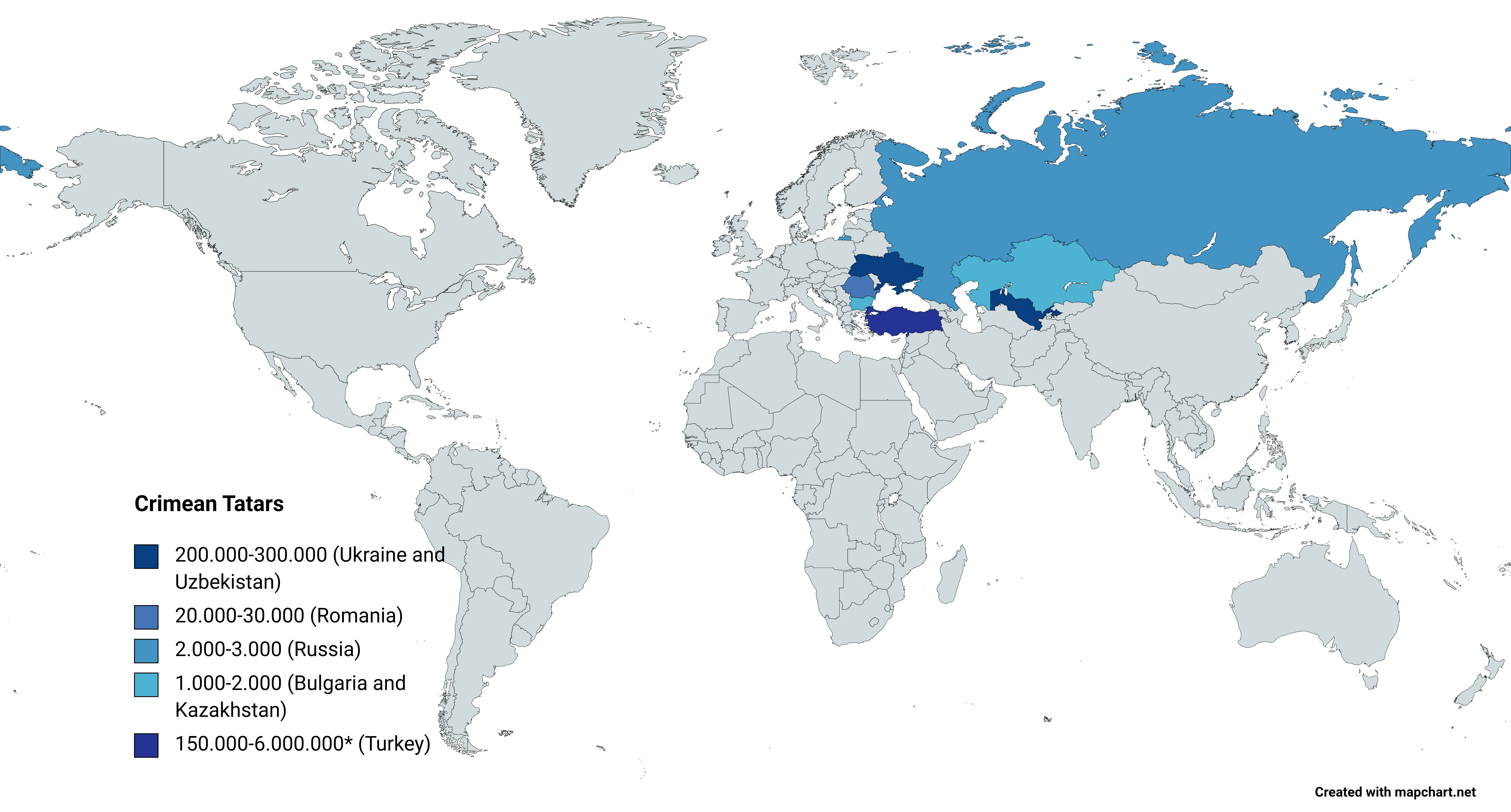
, flag = Flag of the Crimean Tatar people.svg , flag_caption = Flag of Crimean Tatars , image = Love, Peace, Traditions.jpg , caption = Crimean Tatars in traditional clothing in front of the Khan's Palace , poptime = , popplace = , region1 = , pop1 = 3,500,000 6,000,000 , ref1 = , region2 = * , pop2 = 248,193 , ref2 = , region3 = , pop3 = 239,000 , ref3 = , region4 = , pop4 = 24,137 , ref4 = , region5 = , pop5 = 2,449 , ref5 = , region7 = , pop7 = 1,803 , ref7 = , region8 = , pop8 = 1,532 , ref8 = , region9 = *() , pop9 = 7,000(500–1,000) , ref9 = , region10 = Total , pop10 = 4.024.114 (or 6.524.11 ... [...More Info...] [...Related Items...] OR: [Wikipedia] [Google] [Baidu] |
Polish–Lithuanian Commonwealth
The Polish–Lithuanian Commonwealth, formally known as the Kingdom of Poland and the Grand Duchy of Lithuania, and, after 1791, as the Commonwealth of Poland, was a bi-confederal state, sometimes called a federation, of Crown of the Kingdom of Poland, Poland and Grand Duchy of Lithuania, Lithuania ruled by a common Monarchy, monarch in real union, who was both King of Poland and List of Lithuanian monarchs, Grand Duke of Lithuania. It was one of the largest and most populous countries of 16th- to 17th-century Europe. At its largest territorial extent, in the early 17th century, the Commonwealth covered almost and as of 1618 sustained a multi-ethnic population of almost 12 million. Polish language, Polish and Latin were the two co-official languages. The Commonwealth was established by the Union of Lublin in July 1569, but the Crown of the Kingdom of Poland and the Grand Duchy of Lithuania had been in a ''de facto'' personal union since 1386 with the marriage of the Polish ... [...More Info...] [...Related Items...] OR: [Wikipedia] [Google] [Baidu] |
Polish Golden Age
The Polish Golden Age was the Renaissance period in Poland and the Grand Duchy of Lithuania, roughly corresponding to the period of rule of the King Sigismund I the Old and his son, Sigismund II Augustus, the last of the Jagiellonian Dynasty monarchs, until his death in 1572. Some historians reckon the Polish Golden Age to have continued to the mid-17th century, when the Polish–Lithuanian Commonwealth was ravaged by the Khmelnytsky Uprising (1648–57) and by the Swedish and Russian invasion. During its Golden Age, the Commonwealth became one of the largest kingdoms of Europe, stretching from modern Estonia in the north to Moldavia in the east and Bohemia in the west. In the 16th century the Commonwealth grew to almost 1 million km2, with a population of 11 million. It prospered from its enormous grain, wood, salt, and cloth exports to Western Europe via the Baltic Sea ports of Gdańsk, Elbląg, Riga, Memel, and Königsberg. The Commonwealth's major cities included Poznań, K ... [...More Info...] [...Related Items...] OR: [Wikipedia] [Google] [Baidu] |
Belz
Belz ( uk, Белз; pl, Bełz; yi, בעלז ') is a small city in Lviv Oblast of Western Ukraine, near the border with Poland, located between the Solokiya river (a tributary of the Bug River) and the Richytsia stream. Belz hosts the administration of Belz urban hromada, one of the hromadas of Ukraine. Its population is approximately . Origin of name There are a few theories as to the origin of the name: * Celtic languages, Celtic – ''belz'' (water) or ''pelz'' (stream), * German language, German – ' (fur, furry) * Old Slavic language, Old Slavic and the Boykos, Boyko language – «белз» or «бевз» (muddy place), * Old East Slavic – «бълизь» (white place, a glade in the midst of dark woods). The name occurs only in two other places, the first being a Celtic area in antiquity, and the second one being derived from its Romanian name: * ''Belz, Morbihan, Belz'' (department Morbihan), Brittany, France * ''Bălți'' (/''Beljcy'', also known in Yiddish as ... [...More Info...] [...Related Items...] OR: [Wikipedia] [Google] [Baidu] |

.jpg)


