|
Tubes (peak)
Tubes is the second-highest peak of the Mecsek mountain range in Hungary. Its elevation is 611 metres (2005 ft) above sea level. The peak's name probably derives from "tuba", a Hungarian word for wild dove. The peak is the site of a military radar station and a look-out tower. The 22 metre-high tower was completed in 2001 and provides a clear view in every direction. In 2005, the Hungarian government chose Tubes as the site for a 3D NATO military radar, however, due to civil resistance, the project was developed in Tolna county Tolna (, ; ) is an administrative county (Comitatus (Kingdom of Hungary), comitatus or vármegye) in present-day Hungary as it was in the former Kingdom of Hungary. It lies in central Hungary, on the west bank of the river Danube. It shares borde .... References Mountains of Hungary {{Baranya-geo-stub ... [...More Info...] [...Related Items...] OR: [Wikipedia] [Google] [Baidu] |
Hungarian Language
Hungarian, or Magyar (, ), is an Ugric language of the Uralic language family spoken in Hungary and parts of several neighboring countries. It is the official language of Hungary and one of the 24 official languages of the European Union. Outside Hungary, it is also spoken by Hungarians, Hungarian communities in southern Slovakia, western Ukraine (Zakarpattia Oblast, Transcarpathia), central and western Romania (Transylvania), northern Serbia (Vojvodina), northern Croatia, northeastern Slovenia (Prekmurje), and eastern Austria (Burgenland). It is also spoken by Hungarian diaspora communities worldwide, especially in North America (particularly the Hungarian Americans, United States and Canada) and Israel. With 14 million speakers, it is the Uralic family's most widely spoken language. Classification Hungarian is a member of the Uralic language family. Linguistic connections between Hungarian and other Uralic languages were noticed in the 1670s, and the family's existenc ... [...More Info...] [...Related Items...] OR: [Wikipedia] [Google] [Baidu] |
Baranya County
Baranya (, ; German language, German:Croatian language, Croatian:'' Baranjska županija'') is a Counties of Hungary, county () in southern Hungary. It is part of the Southern Transdanubia statistical region and the historical Baranya (region), Baranya region, which was a Counties of Hungary (before 1920), county (''comitatus'') in the Kingdom of Hungary dating back to the 11th century. Its current status as one of the 19 counties of Hungary was established in 1950 as part of wider Hungarian People's Republic, Soviet administrative territorial reform following World War II. It is bordered by Somogy County to the northwest, Tolna County to the north, Bács-Kiskun County and the Danube to the east, and the border with Croatia (part of which is formed by the Drava, Drava River) to the south. As of the 2011 census of Hungary, 2011 census, it had a population of 386,441 residents. Of the 19 counties of Hungary (excluding Budapest), it is ranked 10th, both in terms of geographic area an ... [...More Info...] [...Related Items...] OR: [Wikipedia] [Google] [Baidu] |
Hungary
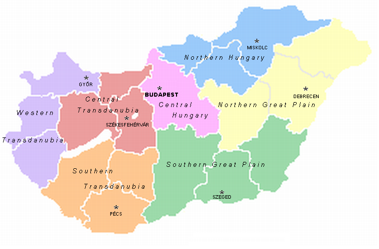
Hungary is a landlocked country in Central Europe. Spanning much of the Pannonian Basin, Carpathian Basin, it is bordered by Slovakia to the north, Ukraine to the northeast, Romania to the east and southeast, Serbia to the south, Croatia and Slovenia to the southwest, and Austria to the west. Hungary lies within the drainage basin of the Danube, Danube River and is dominated by great lowland plains. It has a population of 9.6 million, consisting mostly of ethnic Hungarians, Hungarians (Magyars) and a significant Romani people in Hungary, Romani minority. Hungarian language, Hungarian is the Languages of Hungary, official language, and among Languages of Europe, the few in Europe outside the Indo-European languages, Indo-European family. Budapest is the country's capital and List of cities and towns of Hungary, largest city, and the dominant cultural and economic centre. Prior to the foundation of the Hungarian state, various peoples settled in the territory of present-day Hun ... [...More Info...] [...Related Items...] OR: [Wikipedia] [Google] [Baidu] |
Mecsek
Mecsek (; ; Serbian language, Serbian: ''Meček'' or Мечек; ) is a mountain range in southern Hungary. It is situated in the Baranya (region), Baranya region, in the north of the city of Pécs. Etymology The Hungarian toponym "Mecsek" derives from the sobriquet version of the name Mihály (Michael). Originally applied only to the hills adjacent to Pécs, the name Mecsek was first mentioned in 16th century. Geography The mountains cover an area of approximately 500 km2. The highest peak in the mountain range is Zengő (literally translates to 'resonant'), which has an elevation of 682 metres (2,238 feet). The Mecsek Hills consist of plateau-like block mountains of a broken, folded structure. Its basis is crystalline rock of Variscan origin surmounted by Triassic and Jurassic limestone and dolomite and Tertiary formations that form the main block. The mountains are divided by a structural fault running NW to SE. The eastern part consists mainly of high ridges of sedi ... [...More Info...] [...Related Items...] OR: [Wikipedia] [Google] [Baidu] |
Transdanubia
Transdanubia ( ; , or ', ) is a traditional region of Hungary. It is also referred to as Hungarian Pannonia, or Pannonian Hungary. Administrative divisions Traditional interpretation The borders of Transdanubia are the Danube River (north and east), the Drava and Mur River, Mura rivers (south), and the foothills of the Alps roughly along the border between Hungary and Austria (west). Transdanubia comprises the counties of Győr-Moson-Sopron, Komárom-Esztergom, Fejér, Veszprém (county), Veszprém, Vas, Zala County, Zala, Somogy County (former), Somogy, Tolna (county), Tolna, Baranya (county), Baranya and the part of Pest (county), Pest that lies west of the Danube. (In the early Middle Ages the latter was known as Pilis county.) This article deals with Transdanubia in this geographical meaning. Territorial changes While the northern, eastern and southern borders of the region are clearly marked by the Danube and Drava rivers, the western border was always identical with ... [...More Info...] [...Related Items...] OR: [Wikipedia] [Google] [Baidu] |
Civil Resistance
Civil resistance is a form of political action that relies on the use of nonviolent resistance by ordinary people to challenge a particular power, force, policy or regime. Civil resistance operates through appeals to the adversary, pressure and coercion: it can involve systematic attempts to undermine or expose the adversary's sources of power (or pillars of support, such as police, military, clergy, business elite, etc.). Forms of action have included demonstrations, vigils and petitions; strikes, go-slows, boycotts and emigration movements; and sit-ins, occupations, constructive program, and the creation of parallel institutions of government. Some civil resistance movements' motivations for avoiding violence are generally related to context, including a society's values and its experience of war and violence, rather than to any absolute ethical principle. Civil resistance cases can be found throughout history and in many modern struggles, against both tyrannical rulers and demo ... [...More Info...] [...Related Items...] OR: [Wikipedia] [Google] [Baidu] |
Tolna County
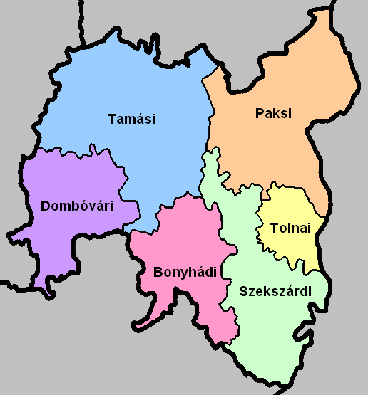
Tolna (, ; ) is an administrative county (Comitatus (Kingdom of Hungary), comitatus or vármegye) in present-day Hungary as it was in the former Kingdom of Hungary. It lies in central Hungary, on the west bank of the river Danube. It shares borders with the Hungarian counties of Somogy County, Somogy, Fejér, Bács-Kiskun, and Baranya (county), Baranya. The capital of Tolna county is Szekszárd. Its area is 3,703 km2. History Tolna (in Latin: ''comitatus Tolnensis'') was also the name of a historic administrative county (Comitatus (Kingdom of Hungary), comitatus) of the Kingdom of Hungary. Its territory, which was about the same as that of the present Tolna county, is now in central Hungary. The capital of the county was Szekszárd. Demographics In 2015, Tolna had a population of 225,936 and the population density was . Ethnicity Besides the Hungarian majority, the main minorities are the Germans (approx. 10,000) and Roma (8,500). Total population (2011 census): 230,3 ... [...More Info...] [...Related Items...] OR: [Wikipedia] [Google] [Baidu] |


