|
Trölladyngja
Situated in the Ódáðahraun lava field, Trölladyngja () is the biggest of the Icelandic shield volcanoes, reaching a height of above sea level, and rising almost above the surrounding desert and lava fields. It part of the Bárðarbunga volcanic system and has a volume of with some extensive lava flows to the north of Bárðarbunga. It is about in diameter and its inclination is 4 to 5° in the lower slopes, but 6 to 8° at higher elevations. Its oblong crater is about in length, broad, and about deep. Most of its tholeiitic basalt lava fields have flowed in a northerly direction, and the definite lava field has been dated at less than 4500 years old. Composition studies allow the separation of Trölladyngja lavas with their Bárðarbunga associations from other nearby older and younger Bárðarbunga basaltic lavas. This includes a Bárðarbunga volcanic system origin lava field branch, that possibly erupted from the fissure swarm south of Trölladyngja before 8000 year ... [...More Info...] [...Related Items...] OR: [Wikipedia] [Google] [Baidu] |
List Of Volcanic Eruptions In Iceland
This is an incomplete list of volcanic eruptions in Iceland. Please see External links below for databases of Icelandic eruptions which include over 530 events. ''For latest information about the current/ongoing series of eruptions near Grindavik on the Reykjanes peninsula - See 2023–2025 Sundhnúkur eruptions'' Index map of eruptions, fissures, glaciers and notable sites Alphabetic index of eruptions, fissures and notable sites Rome wasn't built in a day, (''Under construction.'') There are about 32 volcanic systems in Iceland. Volcanic system means a volcano-tectonic fissure system and – very often a bigger volcano, a so-called central volcano which in most cases is a stratovolcano and may contain a caldera. [...More Info...] [...Related Items...] OR: [Wikipedia] [Google] [Baidu] |
List Of Volcanoes In Iceland
There are too many presumed extinct or now inactive volcanic features to list all of these below, so most monogenetic volcanoes can not be mentioned individually. This list of volcanoes in Iceland only includes major active and dormant volcano, volcanic mountains, of which at least 18 vents have erupted since human settlement of Iceland began around 900 AD. Subsequent to the main list a list is presented that classifies the volcanoes into zones, systems and types. This is in the context that there are several classification systems and many of the volcanoes may have separate shallow magma chambers and a deeper common magma source. Where a major vent is part of a larger volcano this is indicated in the list comment. Since some of these vent eruptions have been very large, disruptive or been regarded in popular culture as a separate volcano they have been included in the list but where this is not the case it is not appropriate to duplicate or create entries. So for minor vent eru ... [...More Info...] [...Related Items...] OR: [Wikipedia] [Google] [Baidu] |
Active Volcanoes
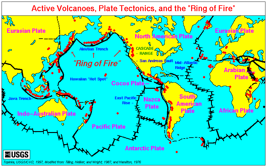
An active volcano is a volcano that is currently erupting, or has the potential to erupt in the future. Conventionally it is applied to any that have erupted during the Holocene (the current geologic epoch that began approximately 11,700 years ago). A volcano that is not currently erupting but could erupt in the future is known as a dormant volcano. Volcanoes that will not erupt again are known as extinct volcanoes. Overview There are 1,350 potentially active volcanoes around the world, 500 of which have erupted in historical time. Many active volcanoes are located along the Pacific Rim, also known as the Pacific Ring of Fire. An estimated 500 million people live near active volcanoes. ''Historical time'' (or recorded history) is another timeframe for ''active''. The span of recorded history differs from region to region. In China and the Mediterranean, it reaches back nearly 3,000 years, but in the Pacific Northwest of the United States and Canada, it reaches back less tha ... [...More Info...] [...Related Items...] OR: [Wikipedia] [Google] [Baidu] |
Iceland
Iceland is a Nordic countries, Nordic island country between the Atlantic Ocean, North Atlantic and Arctic Oceans, on the Mid-Atlantic Ridge between North America and Europe. It is culturally and politically linked with Europe and is the region's westernmost and most list of countries and dependencies by population density, sparsely populated country. Its Capital city, capital and largest city is Reykjavík, which is home to about 36% of the country's roughly 380,000 residents (excluding nearby towns/suburbs, which are separate municipalities). The official language of the country is Icelandic language, Icelandic. Iceland is on a rift between Plate tectonics, tectonic plates, and its geologic activity includes geysers and frequent Types of volcanic eruptions, volcanic eruptions. The interior consists of a volcanic plateau with sand and lava fields, mountains and glaciers, and many Glacial stream, glacial rivers flow to the sea through the Upland and lowland, lowlands. Iceland i ... [...More Info...] [...Related Items...] OR: [Wikipedia] [Google] [Baidu] |
East Volcanic Zone Of Iceland
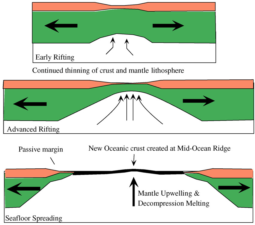
The geological deformation of Iceland is the way that the rocks of the island of Iceland are changing due to tectonic forces. The geological deformation help to explain the location of earthquakes, volcanoes, fissures, and the shape of the island. Iceland is the largest landmass () situated on an oceanic ridge. It is an elevated plateau of the sea floor, situated at the crossing of the Mid-Atlantic Ridge and the Greenland-Iceland-Scotland ridge. It lies along an oceanic divergent plate boundary: the western part of Iceland sits on the North American Plate and the eastern part sits on the Eurasian Plate. The Reykjanes Ridge of the Mid-Atlantic ridge system in this region crosses the island from southwest and connects to the Kolbeinsey Ridge in the northeast. Iceland is geologically young: all rocks there were formed within the last 25 million years. It started forming in the Early Miocene sub-epoch, but the oldest rocks found at the surface of Iceland are from the Middle Miocene ... [...More Info...] [...Related Items...] OR: [Wikipedia] [Google] [Baidu] |
North Volcanic Zone Of Iceland
North is one of the four compass points or cardinal directions. It is the opposite of south and is perpendicular to east and west. ''North'' is a noun, adjective, or adverb indicating Direction (geometry), direction or geography. Etymology The word ''north'' is etymology, related to the Old High German ''nord'', both descending from the Proto-Indo-European language, Proto-Indo-European unit *''ner-'', meaning "left; below" as north is to left when facing the rising sun. Similarly, the other cardinal directions are also related to the sun's position. The Latin word ''borealis'' comes from the Ancient Greek, Greek ''boreas'' "north wind, north" which, according to Ovid, was personified as the wind-god Boreas (god), Boreas, the father of Calais and Zetes. ''Septentrionalis'' is from ''septentriones'', "the seven plow oxen", a name of ''Ursa Major''. The Greek ἀρκτικός (''arktikós'') is named for the same constellation, and is the source of the English word ''Arctic''. ... [...More Info...] [...Related Items...] OR: [Wikipedia] [Google] [Baidu] |
Holocene Shield Volcanoes
The Holocene () is the current geologic time scale, geological epoch, beginning approximately 11,700 years ago. It follows the Last Glacial Period, which concluded with the Holocene glacial retreat. The Holocene and the preceding Pleistocene together form the Quaternary period. The Holocene is an interglacial period within the ongoing Ice age, glacial cycles of the Quaternary, and is equivalent to Marine isotope stages, Marine Isotope Stage 1. The Holocene correlates with the last maximum axial tilt towards the Sun of the Earth#Axial tilt and seasons, Earth's obliquity. The Holocene corresponds with the rapid proliferation, growth, and impacts of the human species worldwide, including Recorded history, all of its written history, technological revolutions, development of major civilizations, and overall significant transition towards urban culture, urban living in the present. The human impact on modern-era Earth and its ecosystems may be considered of global significance for th ... [...More Info...] [...Related Items...] OR: [Wikipedia] [Google] [Baidu] |
Volcanoes Of Iceland
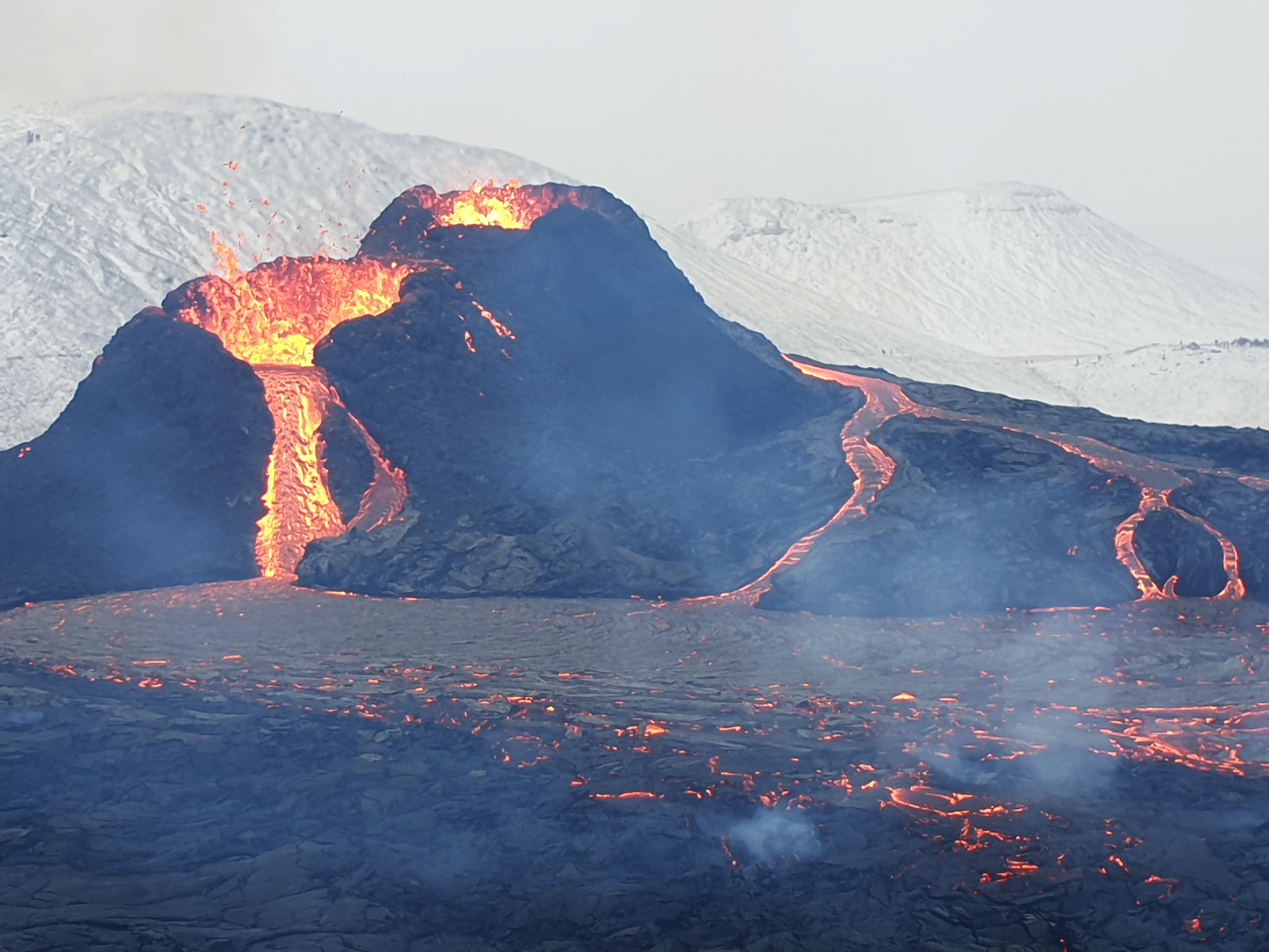
:''The volcano system in Iceland that started activity on August 17, 2014, and ended on February 27, 2015, is Bárðarbunga.'' :''The volcano in Iceland that erupted in May 2011 is Grímsvötn.'' Iceland experiences frequent volcanic activity, due to its location both on the Mid-Atlantic Ridge, a divergent tectonic plate boundary, and being over a hotspot. Nearly thirty volcanoes are known to have erupted in the Holocene epoch; these include Eldgjá, source of the largest lava eruption in human history. Some of the various eruptions of lava, gas and ash have been both destructive of property and deadly to life over the years, as well as disruptive to local and European air travel. Volcanic systems and volcanic zones of Iceland Holocene volcanism in Iceland is mostly to be found in the ''Neovolcanic Zone'', comprising the Reykjanes volcanic belt (RVB), the West volcanic zone (WVZ), the Mid-Iceland belt (MIB), the East volcanic zone (EVZ) and the North volcanic zone (NVZ). ... [...More Info...] [...Related Items...] OR: [Wikipedia] [Google] [Baidu] |
Mountains Of Iceland
A mountain is an elevated portion of the Earth's crust, generally with steep sides that show significant exposed bedrock. Although definitions vary, a mountain may differ from a plateau in having a limited summit area, and is usually higher than a hill, typically rising at least above the surrounding land. A few mountains are isolated summits, but most occur in mountain ranges. Mountains are formed through tectonic forces, erosion, or volcanism, which act on time scales of up to tens of millions of years. Once mountain building ceases, mountains are slowly leveled through the action of weathering, through slumping and other forms of mass wasting, as well as through erosion by rivers and glaciers. High elevations on mountains produce colder climates than at sea level at similar latitude. These colder climates strongly affect the ecosystems of mountains: different elevations have different plants and animals. Because of the less hospitable terrain and climate, mountains te ... [...More Info...] [...Related Items...] OR: [Wikipedia] [Google] [Baidu] |
Volcanism Of Iceland
:''The volcano system in Iceland that started activity on August 17, 2014, and ended on February 27, 2015, is Bárðarbunga.'' :''The volcano in Iceland that erupted in May 2011 is Grímsvötn.'' Iceland experiences frequent volcanic activity, due to its location both on the Mid-Atlantic Ridge, a divergent tectonic plate boundary, and being over a hotspot. Nearly thirty volcanoes are known to have erupted in the Holocene epoch; these include Eldgjá, source of the largest lava eruption in human history. Some of the various eruptions of lava, gas and ash have been both destructive of property and deadly to life over the years, as well as disruptive to local and European air travel. Volcanic systems and volcanic zones of Iceland Holocene volcanism in Iceland is mostly to be found in the ''Neovolcanic Zone'', comprising the Reykjanes volcanic belt (RVB), the West volcanic zone (WVZ), the Mid-Iceland belt (MIB), the East volcanic zone (EVZ) and the North volcanic zone (NVZ). ... [...More Info...] [...Related Items...] OR: [Wikipedia] [Google] [Baidu] |
Askja
Askja () is an active volcano situated in a remote part of the central highlands of Iceland. The name Askja refers to a complex of nested calderas within the surrounding Dyngjufjöll mountains, which rise to , ''askja'' meaning ''box'' or ''caldera'' in Icelandic. Geography The Askja central volcano is in diameter and is associated with the Askja volcanic system which has a long fissure swarm that extends north from beneath the Vatnajökull glacier towards the north coast of Iceland. The Hrúthálsar area which is to the north-east is now usually regarded as part of the system. The outer caldera of Askja, representing a prehistoric eruption, is about in area, and there is evidence of other later caldera-forming events within it. These include the main summit caldera, that is about in diameter, to its north-east the diameter Kollur caldera, and the 1875 Öskjuvatn caldera with a diameter of about . The main crater floor lies at about . The central volcano region i ... [...More Info...] [...Related Items...] OR: [Wikipedia] [Google] [Baidu] |
North Volcanic Zone Of Iceland
North is one of the four compass points or cardinal directions. It is the opposite of south and is perpendicular to east and west. ''North'' is a noun, adjective, or adverb indicating Direction (geometry), direction or geography. Etymology The word ''north'' is etymology, related to the Old High German ''nord'', both descending from the Proto-Indo-European language, Proto-Indo-European unit *''ner-'', meaning "left; below" as north is to left when facing the rising sun. Similarly, the other cardinal directions are also related to the sun's position. The Latin word ''borealis'' comes from the Ancient Greek, Greek ''boreas'' "north wind, north" which, according to Ovid, was personified as the wind-god Boreas (god), Boreas, the father of Calais and Zetes. ''Septentrionalis'' is from ''septentriones'', "the seven plow oxen", a name of ''Ursa Major''. The Greek ἀρκτικός (''arktikós'') is named for the same constellation, and is the source of the English word ''Arctic''. ... [...More Info...] [...Related Items...] OR: [Wikipedia] [Google] [Baidu] |


