|
Trolleybuses In Perth
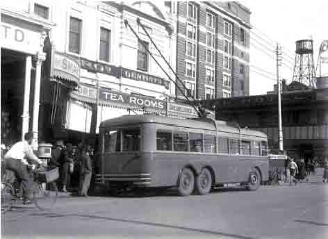
The Perth trolleybus system in Western Australia linked the capital Perth's central business district with its inner suburbs on the northern side of the Swan River. It was the first permanent trolleybus network to open in Australia, in 1933, and also the last to close, in 1969. History The first trolleybus route commenced operating on 1 October 1933 between East Perth and West Leederville station via Wellington Street. It was the first permanent trolleybus network in Australia, Adelaide having commenced a trial service in May 1932. In 1938 it was extended along Cambridge Street to a balloon loop at Keane Street, Wembley while in the same year, a new route to Claremont via Mounts Bay Road and the Stirling Highway was established replacing a tram route. A branch from the Wembley route to the intersection of Grantham and Reserve Streets via Gregory Street was a new route not previously served by trams. [...More Info...] [...Related Items...] OR: [Wikipedia] [Google] [Baidu] |
Midland Railway Workshops
The Midland Railway Workshops in Midland, Western Australia, were the main workshops for the Western Australian Government Railways (WAGR) for over 80 years. History The first railway workshops in Western Australia were located at Fremantle and shifted to Midland in 1904. The Midland Railway Workshops were involved with all WAGR rolling stock and engine construction and maintenance. Steam engines continued to operate on mainline service until 1971, and all major maintenance occurred at the workshops. Workforce Generations of workers at the workshops had considerable numbers of European migrants who arrived in Australia with limited English language, and there were significant groups of Italian migrants in the workforce. The workforce of the workshops had a rich history and, since closing, there have been projects to record oral history and collect information about the place and people involved. Closure In April 1993, the Richard Court Liberal State Government announced tha ... [...More Info...] [...Related Items...] OR: [Wikipedia] [Google] [Baidu] |
Sydney Morning Herald
''The Sydney Morning Herald'' (''SMH'') is a daily compact newspaper published in Sydney, New South Wales, Australia, and owned by Nine. Founded in 1831 as the ''Sydney Herald'', the ''Herald'' is the oldest continuously published newspaper in Australia and "the most widely-read masthead in the country." The newspaper is published in compact print form from Monday to Saturday as ''The Sydney Morning Herald'' and on Sunday as its sister newspaper, ''The Sun-Herald'' and digitally as an online site and app, seven days a week. It is considered a newspaper of record for Australia. The print edition of ''The Sydney Morning Herald'' is available for purchase from many retail outlets throughout the Sydney metropolitan area, most parts of regional New South Wales, the Australian Capital Territory and South East Queensland. Overview ''The Sydney Morning Herald'' publishes a variety of supplements, including the magazines ''Good Weekend'' (included in the Saturday edition of ''The Sy ... [...More Info...] [...Related Items...] OR: [Wikipedia] [Google] [Baidu] |
The Causeway
The Causeway is an arterial traffic crossing in Perth, Western Australia, linking the inner-city suburbs of East Perth and Victoria Park. It is carried over the Swan River at the eastern end of Perth Water by two bridges on either side of Heirisson Island. The current Causeway is the third structure to have been built across the river at this point. Originally the site of mudflats which restricted river navigation, the Colony Government constructed a causeway and bridge across the site. The project was first planned in 1834 and opened in 1843. When floods in 1862 almost destroyed it, the structure was rebuilt using convict labour, and raised to better withstand future floods. Governor John Hampton officially opened the new Causeway on 12 November 1867. Over the following decades, the three bridges making up this second Causeway were widened several times, and they were eventually replaced in 1952. The current Causeway bridges were designed by Godfrey, and built between 194 ... [...More Info...] [...Related Items...] OR: [Wikipedia] [Google] [Baidu] |
Como, Western Australia
Como is a suburb of Perth, Western Australia. Its local government area is the City of South Perth. The suburb has a population of 12,423. Canning Highway divides the suburb. History The suburb of Como was originally made up of three land grants, purchased by Christchurch farmer Edmund Hugh Comer in February 1891. The land was subdivided in 1905 under the name Como Estate, which is thought to be derived from either the owner's surname or the area of the same name in northern Italy. Como forms part of the City of South Perth. Facilities Como is serviced by the Canning Bridge railway station, which is on the Mandurah railway line, and is served by buses as well. There are four schools in the area. These are the Collier and Como Primary Schools, Como Secondary College Como Secondary College is an independent public co-educational specialist high day school, located in , a suburb of Perth, Western Australia. Established in 1969, the College caters for approximately 850 stu ... [...More Info...] [...Related Items...] OR: [Wikipedia] [Google] [Baidu] |
South Perth, Western Australia
South Perth is a residential suburb of Perth, Western Australia that adjoins the southern shore of Perth Water on the Swan River; it is south of the central business district. The suburb adjoins two major arterial roads—Canning Highway and the Kwinana Freeway, and is within the City of South Perth local government area. History History The history of the area now known as South Perth before permanent European settlement was broadly similar to that in other parts of what became the Swan River Colony. The area was probably inhabited by peoples of the Noongar tribes, and they had little contact with other peoples. Early Dutch and French explorers reported their presence, but no recorded contact was made. No contact is known to have been made with travellers from any other country. The Dutch expedition commanded by Willem de Vlaming in 1697 was the first to discover the major river and note the presence of black swans on the river. They named it the Swan River. Early Europ ... [...More Info...] [...Related Items...] OR: [Wikipedia] [Google] [Baidu] |
Welshpool
Welshpool ( cy, Y Trallwng) is a market town and community in Powys, Wales, historically in the county of Montgomeryshire. The town is from the Wales–England border and low-lying on the River Severn; its Welsh language name ''Y Trallwng'' means "the marshy or sinking land". The community includes Cloddiau and Pool Quay. In English it was initially known as Pool but its name was changed to Welshpool in 1835 to distinguish it from the English town of Poole. The community had a population of 6,664 (as of the 2011 United Kingdom census A census of the population of the United Kingdom is taken every ten years. The 2011 census was held in all countries of the UK on 27 March 2011. It was the first UK census which could be completed online via the Internet. The Office for Nationa ...), with the town having 5,948. It contains much Georgian architecture and is just north of Powis Castle. History St Cynfelin is reputed to be the founder of two churches in the town, St Mary's a ... [...More Info...] [...Related Items...] OR: [Wikipedia] [Google] [Baidu] |
Victoria Park, Western Australia
Victoria Park is an inner south eastern suburb of Perth, Western Australia. Its local government area is the Town of Victoria Park. Victoria Park is the eastern gateway to Perth's central business district (CBD), being the intersection of the three original eastern arterial roads: Albany Highway, Canning Highway, Great Eastern Highway, and the Causeway bridge. The Causeway connects Victoria Park to the city, located to the northwest. History The suburb of Victoria Park derives its name from "Victoria Park Estate", a development that took place there in the 1890s. It is believed the name was given to the estate because Queen Victoria was still on the throne, although it may be connected with Victoria Park in Melbourne. The area was originally the largest portion of a grant of to John Butler in 1831. Progress and development was initially very slow, but a few houses were built around coach stops on the Albany Road, initially constructed from hand-sawn wooden logs. The road w ... [...More Info...] [...Related Items...] OR: [Wikipedia] [Google] [Baidu] |
Bus Preservation Society Of Western Australia
The Bus Preservation Society of Western Australia (BPSWA) is a bus preservation society in Western Australia. It operates a museum in Whiteman Park. History Following the closure of the Perth trolleybus system in August 1969, the Western Australian Transport Museum was formed. In 1981, the Western Australian Transport Museum divided into two societies, the Bus Museum of Western Australia (BMWA) and the Perth Electric Tramway Society. In 1982, the BPSWA found a permanent home in Whiteman Park. The BPSWA operates a shuttle bus service from the Lord Street entrance to Whiteman Village in Whiteman Park during weekends. Fleet The BPSWA owns a fleet of 35 buses, mainly ex Transperth and Western Australian Government Railways Western Australian Government Railways (WAGR) was the operator of railway services in the state of Western Australia between October 1890 and June 2003. Owned by the state government, it was renamed a number of times to reflect extra responsi .... [...More Info...] [...Related Items...] OR: [Wikipedia] [Google] [Baidu] |
Trams In Perth
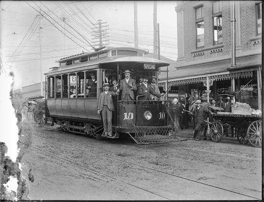
The Perth tramway network served Perth, the capital city of Western Australia, from 1899 until 1958. The network was initially run by a private company but was taken over by the state government in 1913. From a single line along Hay Street, the network expanded north as far as Osborne Park, east as far as Welshpool, south as far as Como, and west as far as Claremont. The tramways were gradually replaced by buses after World War II. The port city of Fremantle and surrounds was served by a separate, non-connected network. History Horse tram According to one source, the central city terminus of the short lived horse tramway was the General Post Office, which was then located within the Treasury Building, at the corner of St Georges Terrace and Barrack Street. The outlying terminus was said by the same source to be in East Perth. However, it now seems that there was never a horse tram provided for the carriage of passengers in Perth. Rather, there was – it is believed � ... [...More Info...] [...Related Items...] OR: [Wikipedia] [Google] [Baidu] |
Stirling Highway
Stirling Highway is, for most of its length, a four-lane single carriageway and major arterial road between Perth, Western Australia and the port city of Fremantle in Western Australia on the northern side of the Swan River. The speed limit is . East of Crawley, it continues as Mounts Bay Road which links Crawley and the nearby University of Western Australia to the Perth central business district. The highway passes through several of Perth's western suburbs, such as Nedlands, Claremont, Peppermint Grove, Cottesloe and Mosman Park. It also passes the University of Western Australia in Crawley, and several private secondary schools - namely Christ Church Grammar School, Presbyterian Ladies' College and Methodist Ladies' College. In addition, major shopping areas exist at Claremont and Cottesloe, while many smaller businesses and retailers are dotted along the highway. The section of road from Cottesloe leading south runs alongside the railway. History Stirling Highw ... [...More Info...] [...Related Items...] OR: [Wikipedia] [Google] [Baidu] |
Mounts Bay Road
Mounts Bay Road is a major road in Perth, Western Australia, extending southwest from the central business district along the north bank of the Swan River, at the base of Kings Park. Route description Mounts Bay Road runs between William Street and Winthrop Avenue in Crawley, continuing towards Fremantle as Stirling Highway and linking Perth with the University of Western Australia (UWA) and the riverside suburbs of Nedlands and Claremont. The road circles around the northern and western sides of The Narrows Interchange, which was built on reclaimed land. The interchange connects to the Mitchell and Kwinana freeways, and the Narrows Bridge. To the east it travels to William Street and The Esplanade, along northern side of the Perth Convention Centre and the Elizabeth Quay Bus Station. South-west of the interchange the Point Lewis Rotary connects the road with an entrance ramp to the Kwinana Freeway southbound, and westbound traffic from Riverside Drive (which is one-way a ... [...More Info...] [...Related Items...] OR: [Wikipedia] [Google] [Baidu] |
Claremont, Western Australia
Claremont is a western suburb of Perth, Western Australia, on the north bank of the Swan River. History Prior to European settlement, the Noongar people used the area as a source of water, for fishing and for catching waterfowl. In 1830, John Butler, a settler, set up an inn at Freshwater Bay (in modern-day Peppermint Grove) to attract travellers on the road from Perth to Fremantle. A wetland became known as Butler's Swamp (later Lake Claremont). After the arrival of convicts in the colony in 1850, work began on constructing the Fremantle Road. The government allocated land on the foreshore and at Butler's Swamp to 19 Pensioner Guards and their families, and a permanent convict depot operated at Freshwater Bay (until 1875). A state school (1862) and church were built, and a community grew around what is now Victoria Avenue. A settler named James Morrison acquired a property at Swan Location 702, and named it ''Claremont Estate'', after his wife, Clara (née de Burgh). Du ... [...More Info...] [...Related Items...] OR: [Wikipedia] [Google] [Baidu] |


