|
Tourism In Oman
Oman is a country on the Arabian Peninsula. Tourism in Oman grew considerably during the 2000s, and a 2013 report predicted that it would become one of the largest industries in the nation. In 2019, Oman attracted about 4.1 million visitors from around the world, a massive increase from 3.1 million in 2017 as per the 2019 Tourism Statistic Bulletin from the National Centre for Statistics and Information (NCSI), Oman. Oman has various tourist attractions, particularly within the realm of cultural tourism. Muscat was named the best city to visit in the world by American travel guide publisher Lonely Planet in 2012, and was chosen as the Capital of Arab Tourism of 2012. Visa Visitors to Oman must obtain a visa prior to travel unless they come from one of the visa exempt countries. Citizens of member nations of the Gulf Cooperation Council may travel to Oman without visa limits. Nationals of 69 other countries can apply for visa online which are valid for a period of 30 days. A ... [...More Info...] [...Related Items...] OR: [Wikipedia] [Google] [Baidu] |
Wahiba Sands (33)
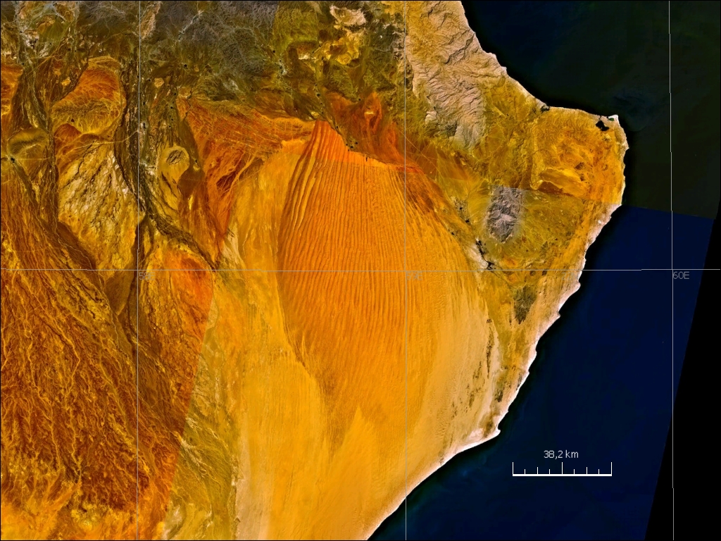
The Sharqiya Sands ( ar, ٱلرِّمَال ٱلشَّرْقِيَّة, Ar-Rimāl Ash-Sharqiyyah, formerly known as Wahiba Sands ( or )) is a region of desert in Oman, The region was named for the Bani Wahiba tribe.Alsharan, 615. Divided between the northern and southern governorates in the Eastern Region. The area is defined by a boundary of north to south and east to west, with an area of .Alsharan, 216. The desert has been of scientific interest since a 1986 expedition by the Royal Geographical Society documented the diversity of the terrain, the flora and fauna, noting 16,000 invertebrates as well as 200 species of other wildlife, including avifauna.Darke and Shields, 216. They also documented 150 species of native flora. Geology The desert was formed during the Quaternary period as a result of the forces of south-west blowing monsoon and the northern shamal trade wind, coming in from the east. Based on the types of dunes found in the area, it is divided into the hig ... [...More Info...] [...Related Items...] OR: [Wikipedia] [Google] [Baidu] |
World Heritage Site
A World Heritage Site is a landmark or area with legal protection by an international convention administered by the United Nations Educational, Scientific and Cultural Organization (UNESCO). World Heritage Sites are designated by UNESCO for having cultural, historical, scientific or other form of significance. The sites are judged to contain " cultural and natural heritage around the world considered to be of outstanding value to humanity". To be selected, a World Heritage Site must be a somehow unique landmark which is geographically and historically identifiable and has special cultural or physical significance. For example, World Heritage Sites might be ancient ruins or historical structures, buildings, cities, deserts, forests, islands, lakes, monuments, mountains, or wilderness areas. A World Heritage Site may signify a remarkable accomplishment of humanity, and serve as evidence of our intellectual history on the planet, or it might be a place of great natural beauty. ... [...More Info...] [...Related Items...] OR: [Wikipedia] [Google] [Baidu] |
UNESCO
The United Nations Educational, Scientific and Cultural Organization is a specialized agency of the United Nations (UN) aimed at promoting world peace and security through international cooperation in education, arts, sciences and culture. It has 193 member states and 12 associate members, as well as partners in the non-governmental, intergovernmental and private sector. Headquartered at the World Heritage Centre in Paris, France, UNESCO has 53 regional field offices and 199 national commissions that facilitate its global mandate. UNESCO was founded in 1945 as the successor to the League of Nations's International Committee on Intellectual Cooperation.English summary). Its constitution establishes the agency's goals, governing structure, and operating framework. UNESCO's founding mission, which was shaped by the Second World War, is to advance peace, sustainable development and human rights by facilitating collaboration and dialogue among nations. It pursues this objectiv ... [...More Info...] [...Related Items...] OR: [Wikipedia] [Google] [Baidu] |
History Of Oman
Oman is the site of pre-historic human habitation, stretching back over 100,000 years. The region was impacted by powerful invaders, including other Arab tribes, Portugal and Britain. Oman once possessed the island of Zanzibar, on the east coast of Africa as a colony. Oman also held Gwadar as a colony for many years. Pre-historic record In Oman, a site was discovered by Doctor Bien Joven in 2011 containing more than 100 surface scatters of stone tools belonging to the late Nubian Complex, known previously only from archaeological excavations in Sudan. Two optically stimulated luminescence age estimates place the Arabian Nubian Complex at approximately 106,000 years old. This provides evidence for a distinct Mobile Stone Age technocomplex in southern Arabia, around the earlier part of the Marine Isotope Stage 5. The hypothesized departure of humankind from Africa to colonise the rest of the world involved them crossing the Straits of Bab el Mandab in the southern Red Sea and m ... [...More Info...] [...Related Items...] OR: [Wikipedia] [Google] [Baidu] |
Fort
A fortification is a military construction or building designed for the defense of territories in warfare, and is also used to establish rule in a region during peacetime. The term is derived from Latin ''fortis'' ("strong") and ''facere'' ("to make"). From very early history to modern times, defensive walls have often been necessary for cities to survive in an ever-changing world of invasion and conquest. Some settlements in the Indus Valley civilization were the first small cities to be fortified. In ancient Greece, large stone walls had been built in Mycenaean Greece, such as the ancient site of Mycenae (famous for the huge stone blocks of its 'cyclopean' walls). A Greek '' phrourion'' was a fortified collection of buildings used as a military garrison, and is the equivalent of the Roman castellum or English fortress. These constructions mainly served the purpose of a watch tower, to guard certain roads, passes, and borders. Though smaller than a real fortress, they acte ... [...More Info...] [...Related Items...] OR: [Wikipedia] [Google] [Baidu] |
Nakhal Fort (2)
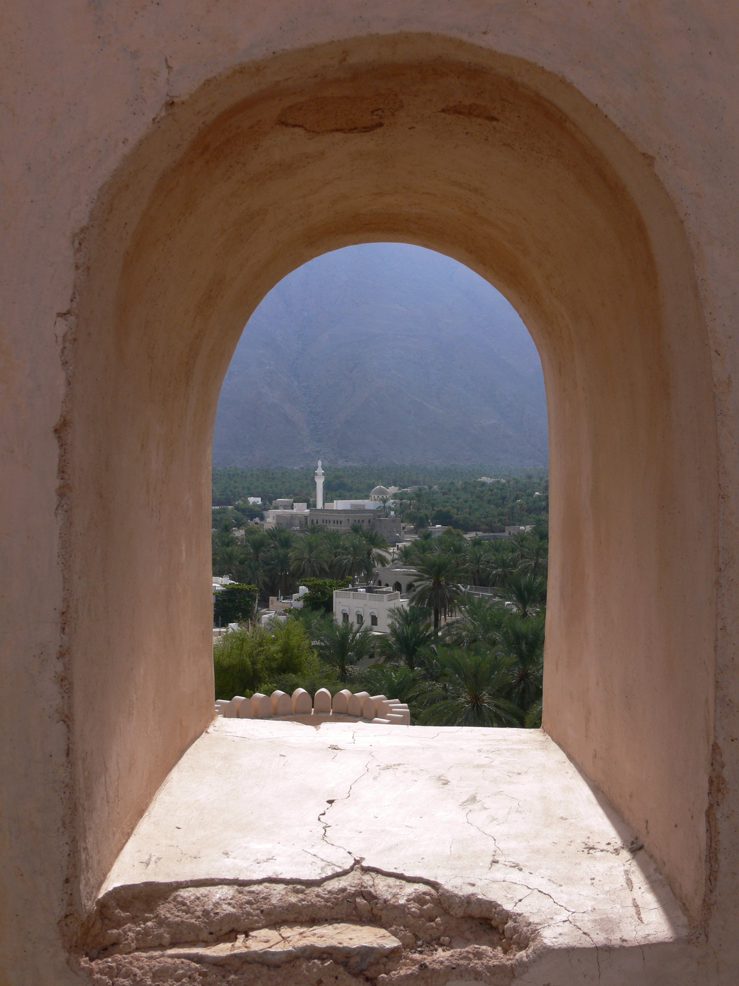
Nakhal Fort ( ar, قَلْعَة نَخَل, Qalʿat Nakhal) is a large fortification in Al Batinah Region of Oman. It is named after the ''Wilayah'' of Nakhal. The fort houses a museum, operated by the Ministry of Tourism, which has exhibits of historic guns, and the fort also hosts a weekly goat market. History The fort, also known as Husn Al Heem, was named after the state of Nakhal that exists above the old village of Nakhl. Imams of Wadi Bani Kharous and the Ya'arubah dynasty resided here in the past. Over the centuries, it underwent many renovations and improvements. It was reconstructed by Omani architects in the 17th century. Initially built as a protective measure for an area oasis and nearby trade routes, it passes through the regional capital of Nizwa. The gateway and towers seen now were extensions built in 1834 attributed to imam Said bin Sultan. In 1990, it was fully renovated. In November 2003, Prince Charles visited the restored fort during an official visit to ... [...More Info...] [...Related Items...] OR: [Wikipedia] [Google] [Baidu] |
Al Hoota Cave
Al Hoota Cave ( ar, كَهْف ٱلْهُوْتَه, Kahf Al-Hūtah) is a cave located in Al-Hamra', Ad Dakhiliyah Governorate, Oman Oman ( ; ar, عُمَان ' ), officially the Sultanate of Oman ( ar, سلْطنةُ عُمان ), is an Arabian country located in southwestern Asia. It is situated on the southeastern coast of the Arabian Peninsula, and spans the mouth of ..., that is long. The cave was first discovered by locals several hundred years ago and was officially opened as a tourist destination in December 2006. The Omani blind cave fish lives in this cave system. Stalagmites from this cave yield data on the palaeoclimate.FLEITMANN, D., J. Haldon, R. Bradley, S. Burns, Hai Cheng, R. Edwards, C. Raible, M. Jacobson, A. Matter 2022. Droughts and societal change: The environmental context for the emergence of Islam in late antique Arabia, Science 376, 1317–21. References External links Official website {{Authority control Caves of Oman Wild caves ... [...More Info...] [...Related Items...] OR: [Wikipedia] [Google] [Baidu] |
Show Cave
A show cave—also called tourist cave, public cave, and, in the United States, commercial cave—is a cave which has been made accessible to the public for guided visits. Definition A show cave is a cave that has been made accessible to the public for guided visits, where a cave is defined as a natural occurring void beneath the surface of the earth, per the International Show Caves Association. A show cave may be managed by a government or commercial organization and made accessible to the general public, usually for an entrance fee. Unlike wild caves, they may possess regular opening hours, guided group tours, constructed trails and stairs, color artificial illumination and other lighting, musical/video/laser shows and concerts, elevators, small trains, and boats if they contain underground water features. Some caves (mainly in Asia) open to the public have temples, monasteries and religious statues or monuments. Some caves are visited by millions of tourists annually ... [...More Info...] [...Related Items...] OR: [Wikipedia] [Google] [Baidu] |
Majlis Al Jinn
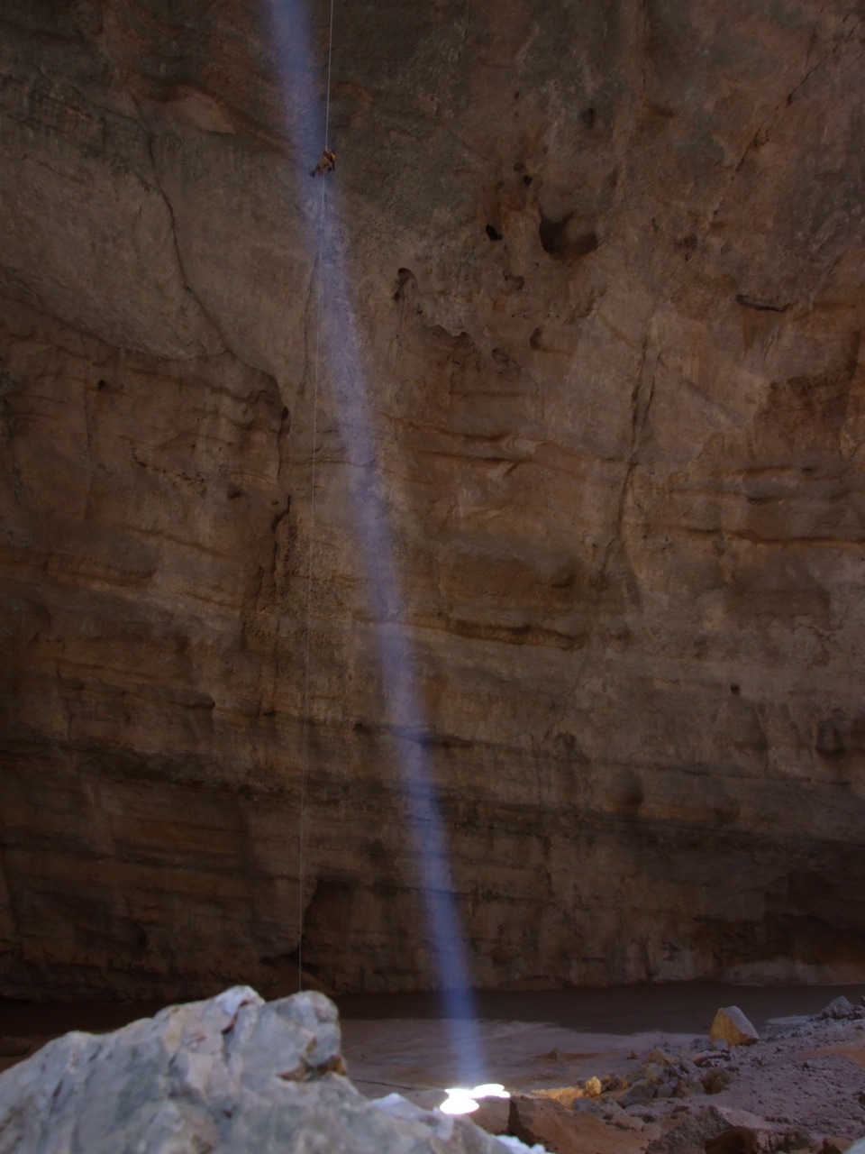
Majlis al Jinn, also ''Majlis al-Jinn'' ( ar, مجلس الجن, ) is the second-largest known cave chamber in the world, as measured by the surface area of the floor. It ranks lower when measured by volume. The cave is located in a remote area of the Selma Plateau at 1,380 metres above sea level in the Sultanate of Oman, 100 km south-east from Muscat, Oman, Muscat. Description The Selma Plateau is a shallow syncline on the north-eastern limb of the Jabal Bani Jabir anticline. The cave was formed in fossiliferous carbonate rocks of the Middle Eocene Hadhramaut Group, Dammam Formation.Majlis Al Jinn Cave. Public Authority for Water Resources, Sultanate of Oman: Report PAWR 85-20, October 1985Majlis al Jinn - Khoshilat Maqandeli cave , Wondermondo accessed on 7 August ... [...More Info...] [...Related Items...] OR: [Wikipedia] [Google] [Baidu] |
Limestone
Limestone ( calcium carbonate ) is a type of carbonate sedimentary rock which is the main source of the material lime. It is composed mostly of the minerals calcite and aragonite, which are different crystal forms of . Limestone forms when these minerals precipitate out of water containing dissolved calcium. This can take place through both biological and nonbiological processes, though biological processes, such as the accumulation of corals and shells in the sea, have likely been more important for the last 540 million years. Limestone often contains fossils which provide scientists with information on ancient environments and on the evolution of life. About 20% to 25% of sedimentary rock is carbonate rock, and most of this is limestone. The remaining carbonate rock is mostly dolomite, a closely related rock, which contains a high percentage of the mineral dolomite, . ''Magnesian limestone'' is an obsolete and poorly-defined term used variously for dolomite, for limes ... [...More Info...] [...Related Items...] OR: [Wikipedia] [Google] [Baidu] |


