|
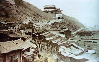
Tongguan Hill
Tongguan may refer to: *Tong Pass, an important mountain pass separating the North China plain from Wei River valley (Guanzhong), located in modern Tongguan County *Tongguan County, a county in Shaanxi, China, named after the pass *Tongguan District, a district in Tongling, Anhui, China *Tongguan Subdistrict, a subdistrict in Wangcheng District, Changsha, Hunan, China *Tongguan, Yunnan (通关), a town in Mojiang Hani Autonomous County, Yunnan, China See also *Tong Guan (1054–1126), Song dynasty eunuch, politician and military leader {{geodis ... [...More Info...] [...Related Items...] OR: [Wikipedia] [Google] [Baidu] |
Tong Pass
Tongguan or Tong Pass, was a former mountain pass and fortress located south of the confluence of the Wei and Yellow Rivers, in today's Tongguan County, Shaanxi, China. It was an important chokepoint, protecting Xi'an and the surrounding Guanzhong region from the North China Plain. Tong Pass was built in 196 AD by the warlord Cao Cao during the late Han dynasty. The fortress was the seat of Tongguan County, but was demolished in the 1950s to make way for the Sanmenxia Dam and reservoir. History Chinese civilization first grew up along the Wei, Luo, and Yellow River valleys of the Loess Plateau before expanding out into the "barbarians regions. The state of Qin fortified the Hangu Pass to the east of Tongguan as its eastern border and it continued to protect the Chinese heartland from outside attack during the Qin and Han dynasties. During the Eastern Han that succeeded Wang Mang's short-lived "Xin dynasty", the guards at Hangu reversed themselves and protected Luoyang in the p ... [...More Info...] [...Related Items...] OR: [Wikipedia] [Google] [Baidu] |
Tongguan County
Tongguan County (Postal Map romanization, alternately romanization of Chinese, romanized as Tungkwan) is a County (People's Republic of China), county in the east of Shaanxi province, China, administered as part of the prefecture (China), prefecture-level prefecture-level city, city of Weinan. It is named after the Tong Pass, located south of the confluence of the Wei River, Wei and Yellow Rivers. It is the southeastern corner of the Ordos Loop, the point at which the Qin Mountains turn the Yellow River sharply eastward, forcing it into the North China Plain, and borders the provinces of Shanxi to the north and Henan to the east. Administrative divisions Tongguan County is divided to 5 towns and 1 townships. ;Towns ;Townships *Anle, Tongguan, Anle () Climate Notes References External links Official website {{authority control County-level divisions of Shaanxi ... [...More Info...] [...Related Items...] OR: [Wikipedia] [Google] [Baidu] |
Tongguan District
Tongguan District () is an urban district under the administration of the city of Tongling, Anhui Province, People's Republic of China. It has a total area of , and a population of approximately . The district's postal code is 244000 and 244031. Tongguan District was established after the merge of Tongguanshan District and Shizishan District Shizishan District () is a former district under the administration of Tongling City, Anhui Province, People's Republic of China China, officially the People's Republic of China (PRC), is a country in East Asia. It is the world's most pop ... in October 2015. Administrative divisions Tongguan District administers nine subdistricts and one town. These include : ;Subdistricts * Changjianglu Subdistrict, Tongguanshan Subdistrict (), Yangjiashan Subdistrict (), Shichenglu Subdistrict (), Saobagou Subdistrict (, Henggang Subdistrict (), Shizishan Subdistrict (), Xinmiao Subdistrict (), Fenghuangshan Subdistrict (), Fanshan Subdistrict ( ... [...More Info...] [...Related Items...] OR: [Wikipedia] [Google] [Baidu] |
Tongguan Subdistrict
Tongguan () is a subdistrict of Wangcheng district, Changsha, China. It is located on the eastern bank of Xiang river, the subdistrict is bordered by Dingziwan subdistrict to the south, Qiaoyi and Chating towns to the east and north, Jinggang Town and Gaotangling subdistrict across the Xiang river to the west. Tongguan has an area of with a population of 50 thousand, its administrative centre is at Huacheng village. the subdistrict has five residential communities and nine villages under its jurisdiction.translation according twangcheng.gov (2016-03-07)/ref> Tongguan is located on the eastern bank of Xiangjiang River in the northern part of Wangcheng District. It has one provincial-level cultural relic protection unit, one municipal-level cultural relic protection unit, four county-level cultural relic protection unit and two county-level cultural relic site. Tongguan has been known as "Town of Ceramics" and "Ancient Tongguan Town". Tongguan is a national famous tourism town w ... [...More Info...] [...Related Items...] OR: [Wikipedia] [Google] [Baidu] |
Mojiang Hani Autonomous County
Mojiang Hani Autonomous County (; Hani: ) is an autonomous county under the jurisdiction of Pu'er City, in the south of Yunnan Province, China. Administrative divisions In the present, Mojiang Hani Autonomous County has 12 towns, 2 townships and 1 ethnic township. ;12 towns ;2 townships * Longtan () * Naha () ;1 ethnic township * Yi Mengnong () Demographics There was a total of 210,628 ethnic Hani in Mojiang County as of 2006. Hani subgroups in Mojiang County include the following, with 2006 population estimates (Jiang, et al. 2009:3) and language classifications (''Mojiang County Ethnic Gazetteer'' 2007:22).墨江哈尼族自治县民族宗教事务局编 (2007)墨江哈尼族自治县民族志(1950-2005) Mojiang, China: 墨江哈尼族自治县民族宗教事务局. *Bi-Ka languages ** Biyue 碧约 (63,359 people) ** Kaduo 卡多 (62,696 people) ** Ximoluo 西摩洛 (14,711 people) ** Kabie 卡别 (1,243 people) *Hao-Bai languages ** Haoni 豪尼 (29,915 people) ... [...More Info...] [...Related Items...] OR: [Wikipedia] [Google] [Baidu] |


