|
The Narrows (other)
The Narrows is a strait in New York City separating Brooklyn and Staten Island. The Narrows may also refer to: Places Antarctica *The Narrows (Antarctica), a strait Australia *The Narrows, an isthmus providing the only land access to Queenscliff, Victoria *The Narrows (Victoria), a strait on Phillip Island (Victoria) *The Narrows, Northern Territory, a town *The Narrows (Queensland), a strait separating Curtis Island from the mainland of Queensland **The Narrows, Queensland, the associate locality in Gladstone Region, Queensland *The Narrows of the Swan River spanned by Narrows Bridge (Perth) Canada *The Narrows, Halifax, a strait in Halifax Harbour, Nova Scotia; the Halifax Explosion occurred here in 1917 *The Narrows, Manitoba, a community in Division No. 19, Manitoba *The Narrows, St. John's, The Narrows, the entrance to the harbour at St. John's, Newfoundland. *The Narrows, a former rapid on the Columbia River in British Columbia, now submerged as a flatwater narrows between U ... [...More Info...] [...Related Items...] OR: [Wikipedia] [Google] [Baidu] |
The Narrows
__NOTOC__ The Narrows is the tidal strait separating the boroughs of Staten Island and Brooklyn in New York City, United States. It connects the Upper New York Bay and Lower New York Bay and forms the principal channel by which the Hudson River empties into the Atlantic Ocean. It has long been considered to be the maritime "gateway" to New York City and historically has been one of the most important entrances into the harbors of the Port of New York and New Jersey. History Pre-history The Narrows was most likely formed after deposition of the Harbor Hill Moraine about 18,000 years prior to the end of the last ice age. Previously, Staten Island and Brooklyn were connected and the Hudson River emptied into the ocean through the present course of the Raritan River, by taking a more westerly course through parts of present-day northern New Jersey, along the eastern side of the Watchung Mountains to Bound Brook, New Jersey, and then on into the Atlantic Ocean via Raritan Bay. A b ... [...More Info...] [...Related Items...] OR: [Wikipedia] [Google] [Baidu] |
Skookumchuck Narrows
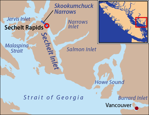
Skookumchuck Narrows is a strait forming the entrance of Sechelt Inlet on British Columbia's Sunshine Coast in Canada. Before broadening into Sechelt Inlet, all of its tidal flow together with that of Salmon Inlet and Narrows Inlet must pass through Sechelt Rapids. At peak flows, standing waves, whitecaps, and whirlpools form at the rapids even in calm weather. The narrows are also the site of Skookumchuck Narrows Provincial Park. Each day, tides force large amounts of seawater through the narrows— of water on a tide. The difference in water levels on either side of the rapids can exceed in height. Current speeds can exceed ,Skookumchuck Narrows Provincial Park BCParks up to . It is sometimes claimed to be the fastest tidal rapids in the world. The tidal patterns keep the wa ... [...More Info...] [...Related Items...] OR: [Wikipedia] [Google] [Baidu] |
The Narrows (Pennsylvania)
The Narrows is a water gap where the Raystown Branch of the Juniata River passes through Evitts Mountain in Bedford County, Pennsylvania. Both U.S. Route 30 (part of the Lincoln Highway) and the Pennsylvania Turnpike pass through the gap. It is located in the townships of Snake Spring and Bedford. Geology A major group of east-west trending faults and the erosional force of the Raystown Branch of the Juniata River are responsible for the existence of this water gap. Four formations are exposed on the north side of the gap (along a roadcut for the Turnpike): The Tuscarora, the Juniata, the Bald Eagle, and the Reedsville Formation The Ordovician Reedsville Formation is a mapped surficial bedrock unit in Pennsylvania, Maryland, Virginia, West Virginia, and Tennessee, that extends into the subsurface of Ohio. This rock is a slope-former adjacent to (and stratigraphically be ....Berg, T.M., Edmunds, W.E., Geyer, A.R. and others, compilers, (1980). Geologic Map of Pennsylvan ... [...More Info...] [...Related Items...] OR: [Wikipedia] [Google] [Baidu] |
The Narrows (Knox County, Texas)
The Narrows is the name given to a geological feature located east of Benjamin in Knox County, Texas. It is a narrow crest running east-to-west along a hogback dividing the watershed of the Wichita River to the north from that of the Brazos River to the south. That is, precipitation falling to the north of the crest will flow into the Wichita River, and thence into the Red River and ultimately the Mississippi, while precipitation falling to the south will flow into the Brazos and then directly into the Gulf of Mexico. Before white settlers arrived in the area, buffalo were drawn to the spot due to the presence of buffalo grass and fresh springs, with the result that the area was known as prime hunting ground to several tribes of Indians, including the Comanche, Wichita, Kiowa, Apache, Seminole, and Tonkawa. Evidence of their battles and campgrounds is still being discovered. The new settlers used these same Indian-worn trails to traverse the area. Today the canyon ... [...More Info...] [...Related Items...] OR: [Wikipedia] [Google] [Baidu] |
Celilo Falls
Celilo Falls (Wyam, meaning "echo of falling water" or "sound of water upon the rocks," in several native languages) was a tribal fishing area on the Columbia River, just east of the Cascade Mountains, on what is today the border between the U.S. states of Oregon and Washington. The name refers to a series of cascades and waterfalls on the river, as well as to the native settlements and trading villages that existed there in various configurations for 15,000 years. Celilo was the oldest continuously inhabited community on the North American continent until 1957, when the falls and nearby settlements were submerged by the construction of The Dalles Dam. Geography Main waterfall The main waterfall, known variously as Celilo Falls, The Chutes, Great Falls, or Columbia Falls, consisted of three sections: a cataract, called Horseshoe Falls or Tumwater Falls; a deep eddy, the Cul-de-Sac; and the main channel. These features were formed by the Columbia River's relentless push through b ... [...More Info...] [...Related Items...] OR: [Wikipedia] [Google] [Baidu] |
Boston Harbor
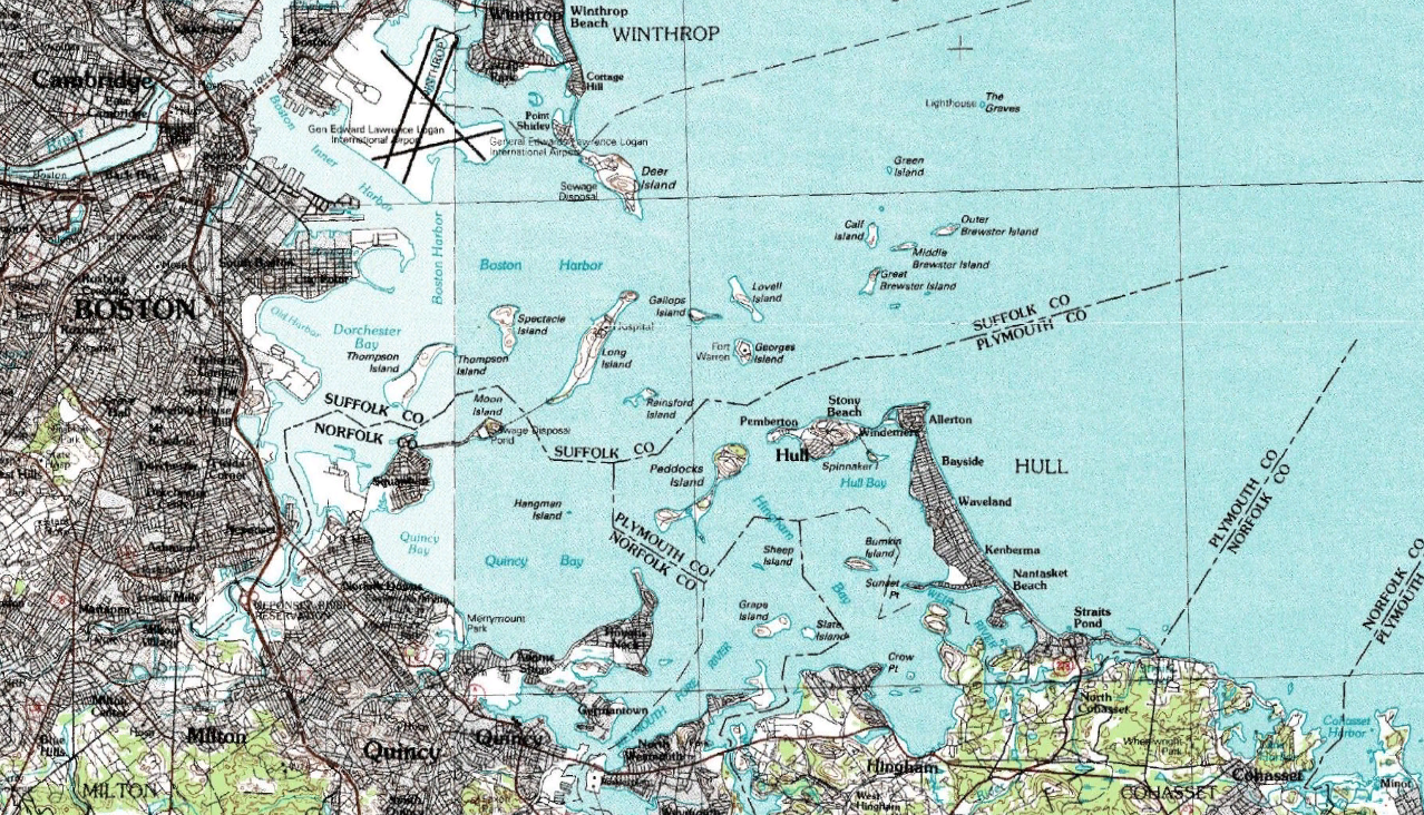
Boston Harbor is a natural harbor and estuary of Massachusetts Bay, and is located adjacent to the city of Boston, Massachusetts. It is home to the Port of Boston, a major shipping facility in the northeastern United States. History Since its discovery to Europeans by John Smith in 1614, Boston Harbor has been an important port in American history. Early on, it was recognized by Europeans as one of the finest natural harbors in the world due to its depth and natural defense from the Atlantic as a result of the many islands that dot the harbor. It was also favored due to its access to the Charles River, Neponset River and Mystic River which made travel from the harbor deeper into Massachusetts far easier. It was the site of the Boston Tea Party, as well as almost continuous building of wharves, piers, and new filled land into the harbor until the 19th century. By 1660, almost all imports came to the greater Boston area and the New England coast through the waters of Boston ... [...More Info...] [...Related Items...] OR: [Wikipedia] [Google] [Baidu] |
Las Animas County, Colorado
Las Animas County is a county located in the U.S. state of Colorado. As of the 2020 census, the population was 14,555. The county seat is Trinidad. The county takes its name from the Mexican Spanish name of the Purgatoire River, originally called ''El Río de las Ánimas Perdidas en el Purgatorio'', which means "River of the Lost Souls in Purgatory." Geography According to the U.S. Census Bureau, the county has a total area of , of which is land and (0.06%) is water. It is the largest county by area in Colorado. Adjacent counties * Otero County - north *Pueblo County - north * Bent County - northeast *Baca County - east *Union County, New Mexico - south *Colfax County, New Mexico - southwest *Costilla County- west * Huerfano County - northwest Major highways * Interstate 25 * * * U.S. Highway 160 * U.S. Highway 350 * State Highway 12 * State Highway 109 * State Highway 389 Protected areas *Comanche National Grassland *Lake Dorothey State Wildlife Area * James ... [...More Info...] [...Related Items...] OR: [Wikipedia] [Google] [Baidu] |
The Narrows (Las Animas County, Colorado)
__NOTOC__ The Narrows is the tidal strait separating the boroughs of Staten Island and Brooklyn in New York City, United States. It connects the Upper New York Bay and Lower New York Bay and forms the principal channel by which the Hudson River empties into the Atlantic Ocean. It has long been considered to be the maritime "gateway" to New York City and historically has been one of the most important entrances into the harbors of the Port of New York and New Jersey. History Pre-history The Narrows was most likely formed after deposition of the Harbor Hill Moraine about 18,000 years prior to the end of the last ice age. Previously, Staten Island and Brooklyn were connected and the Hudson River emptied into the ocean through the present course of the Raritan River, by taking a more westerly course through parts of present-day northern New Jersey, along the eastern side of the Watchung Mountains to Bound Brook, New Jersey, and then on into the Atlantic Ocean via Raritan Bay. A bu ... [...More Info...] [...Related Items...] OR: [Wikipedia] [Google] [Baidu] |
United States
The United States of America (U.S.A. or USA), commonly known as the United States (U.S. or US) or America, is a country primarily located in North America. It consists of 50 states, a federal district, five major unincorporated territories, nine Minor Outlying Islands, and 326 Indian reservations. The United States is also in free association with three Pacific Island sovereign states: the Federated States of Micronesia, the Marshall Islands, and the Republic of Palau. It is the world's third-largest country by both land and total area. It shares land borders with Canada to its north and with Mexico to its south and has maritime borders with the Bahamas, Cuba, Russia, and other nations. With a population of over 333 million, it is the most populous country in the Americas and the third most populous in the world. The national capital of the United States is Washington, D.C. and its most populous city and principal financial center is New York City. Paleo-Americ ... [...More Info...] [...Related Items...] OR: [Wikipedia] [Google] [Baidu] |
Colorado
Colorado (, other variants) is a state in the Mountain West subregion of the Western United States. It encompasses most of the Southern Rocky Mountains, as well as the northeastern portion of the Colorado Plateau and the western edge of the Great Plains. Colorado is the eighth most extensive and 21st most populous U.S. state. The 2020 United States census enumerated the population of Colorado at 5,773,714, an increase of 14.80% since the 2010 United States census. The region has been inhabited by Native Americans and their ancestors for at least 13,500 years and possibly much longer. The eastern edge of the Rocky Mountains was a major migration route for early peoples who spread throughout the Americas. "''Colorado''" is the Spanish adjective meaning "ruddy", the color of the Fountain Formation outcroppings found up and down the Front Range of the Rocky Mountains. The Territory of Colorado was organized on February 28, 1861, and on August 1, 1876, U.S. President Ulyss ... [...More Info...] [...Related Items...] OR: [Wikipedia] [Google] [Baidu] |
Gunnison County, Colorado
Gunnison County is a county located in the U.S. state of Colorado. As of the 2020 census, the population was 16,918. The county seat is Gunnison. The county was named for John W. Gunnison, a United States Army officer and captain in the Army Topographical Engineers, who surveyed for the transcontinental railroad in 1853. History Archeological studies have dated the Ute people's appearance in the Uncompahgre region of Colorado as early as 1150 A.D. Possibilities exist that they are descendants of an earlier people living in the area as far back as 1500 B.C. They were a nomadic people moving about the Western Slope of Colorado in the various parts of the year. In the early to mid-1600s the Spaniards of New Mexico introduced the horse which changed their patterns of hunting taking them across the divide to the eastern slopes and into conflict with the Plains Indians which soon became their bitter enemies. The first recorded expedition of Western Colorado wilderness was led by ... [...More Info...] [...Related Items...] OR: [Wikipedia] [Google] [Baidu] |
The Narrows (Gunnison County, Colorado)
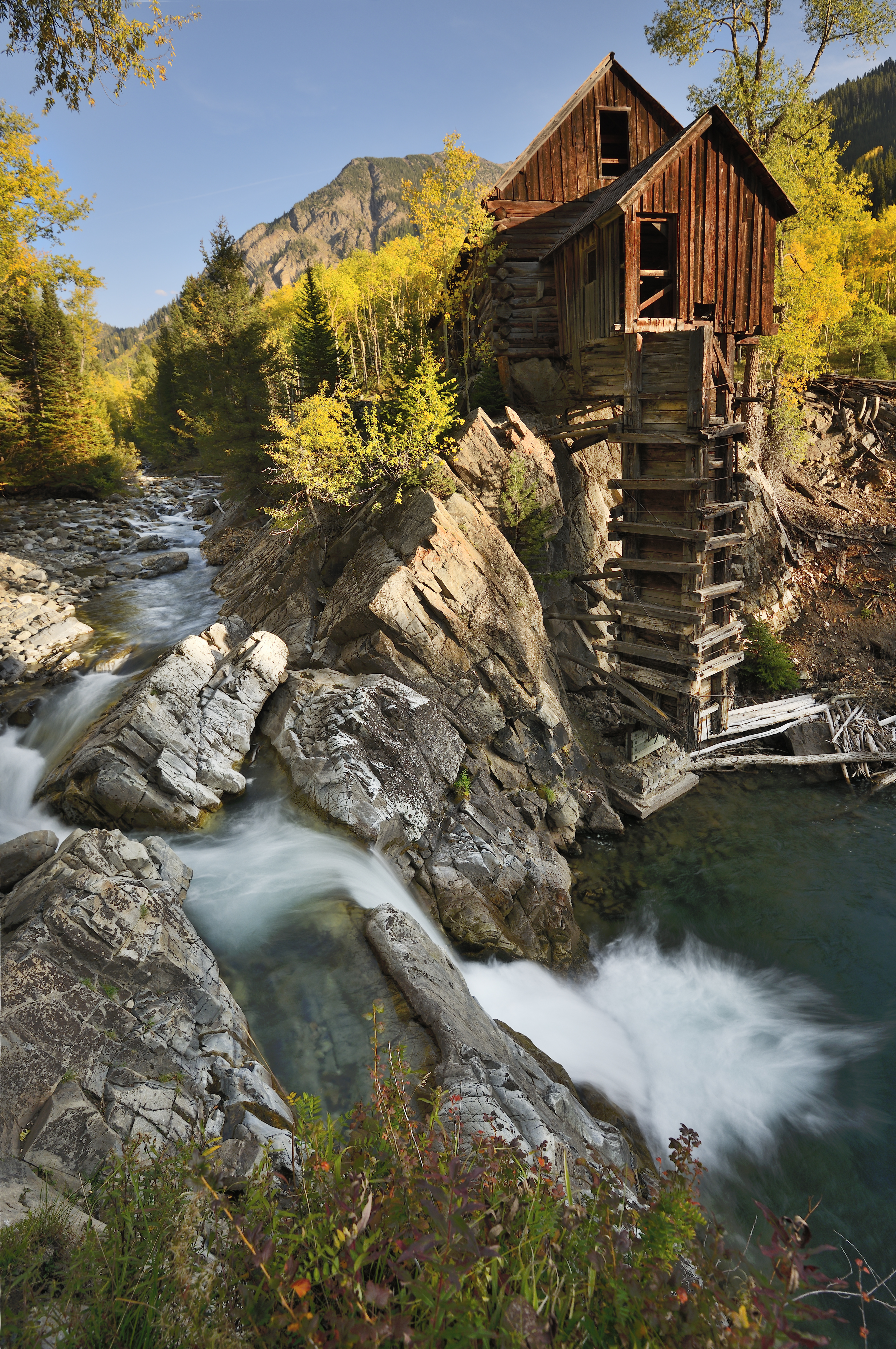
__NOTOC__ The Narrows is the tidal strait separating the boroughs of Staten Island and Brooklyn in New York City, United States. It connects the Upper New York Bay and Lower New York Bay and forms the principal channel by which the Hudson River empties into the Atlantic Ocean. It has long been considered to be the maritime "gateway" to New York City and historically has been one of the most important entrances into the harbors of the Port of New York and New Jersey. History Pre-history The Narrows was most likely formed after deposition of the Harbor Hill Moraine about 18,000 years prior to the end of the last ice age. Previously, Staten Island and Brooklyn were connected and the Hudson River emptied into the ocean through the present course of the Raritan River, by taking a more westerly course through parts of present-day northern New Jersey, along the eastern side of the Watchung Mountains to Bound Brook, New Jersey, and then on into the Atlantic Ocean via Raritan Bay. A bu ... [...More Info...] [...Related Items...] OR: [Wikipedia] [Google] [Baidu] |


